Weather News Archive 2018 December
Image 1: National Temperature Maximum Forecast Map
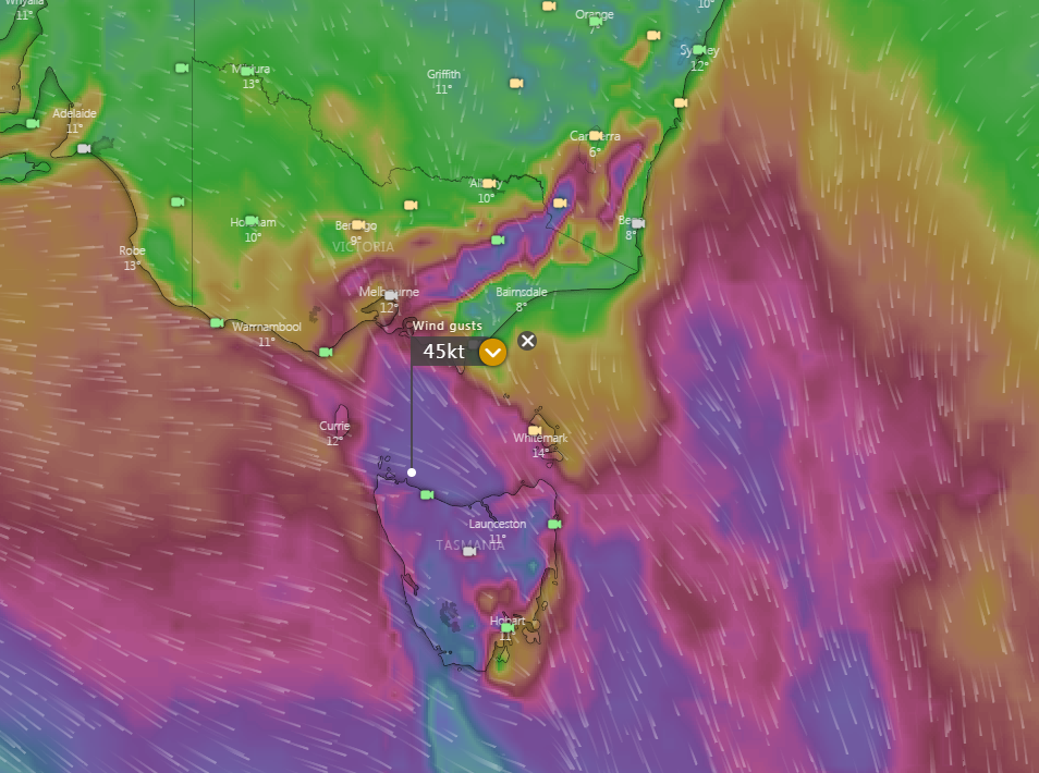
Image 1: European Ensemble (ECWMF) via Windy. Peak wind gusts for Saturday - 11:00pm 30th May, 2020.
A significant cold front is expected to move across the Great Australian Bight as a high pressure systems shifts further east of Tasmania and into the Tasman Sea. Model ensemble confidence is good predicting the passage of the front to move through Bass Strait and affect parts of southern Victoria and Tasmania late Saturday night and into early Sunday morning.
The potential for severe thunderstorms is considered low at this stage, however there is the high potential for squally showers on both Saturday and Sunday, becoming slightly less likely on Sunday in wake of the front, with daytime temperatures plummeting to between 14° to 10° with overnight temperatures returning to single digits.
During Monday, cold and cloudy conditions are expected with potential snow showers are expected typically falling above 1000m in altitude and may lower to 850m later in the evening for elevated regions through Tasmania. Daytime temperatures are expected to become cooler than the weekend into early next week with a projected maximums of between 12° to 9° during the day, depending on location, with overnight minimums expected to 4°.
Snow showers are also possible during Monday especially about the southern inland regions of Victoria, with the slight chance of small hail mixed in with activity. These should also be mostly confined to the Australian Alps above 800m with the potential for sleet and snow flurries along the southern ranges of New South Wales northward towards the Central Tablelands.
On Tuesday and into the mid-week, a large and very broad low pressure system is then expected to lie east of Tasmania and Victoria in the Tasman Sea, directing strong to gusty winds and potentially damaging surf conditions along coastal districts with emphasis on eastern coastal parts of Tasmania, eastern Victoria and southeastern coastal districts of New South Wales. Timing and intensity of the low is subject to change as we get closer towards the start of next week.
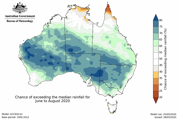
Image 1: Chance of exceeding the median rainfall for June to August 2020
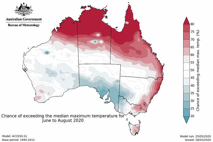
Image 2: Chance of exceeding the median maximum temperature for June to August 2020
The Bureau of Meteorology has released their winter outlook for Australia, with wetter than average conditions predicted for large parts of the country.
A warmer than average eastern Indian Ocean will be one of the main drivers of this wetter pattern, increasing the availability of moisture of any systems crossing the nation. A warmer Indian Ocean has been strongly linked to an increase in northwest cloudbands, which are well known generators of widespread rainfall across inland areas and cold day time temperatures, such as the one that affected Australia last week.
Meanwhile, the tropical central and eastern Pacific Ocean will cool over the coming months, with several models hinting at a La Nina developing later this year, which would further enhance the wet signal over Australia. This is almost the opposite to what was experienced last year when Australia had record dry conditions, due to a cool Indian Ocean and a El Nino Modoki (where warming occurs in the central Pacific Ocean instead of the eastern Pacific).
Wetter than average conditions are likely across large parts of the country, although this becomes more uncertain over southwest WA, Tasmania and the NSW and VIC coasts where there are no strong indications of whether conditions will be wetter or drier than average.
More cloud cover will cause an increased chance of cooler than average days over southeast WA, southern SA, southwest NSW and western Victoria, however warmer than average daytime temperatures are likely across many parts of northern and eastern Australia. Nights will likely be warmer than average, as cloud traps in the warmth in at night time.
With these climate drivers in place and the enhanced wetter, it is looking unlikely the coming bushfire season will be anywhere near as bad as the one just gone.
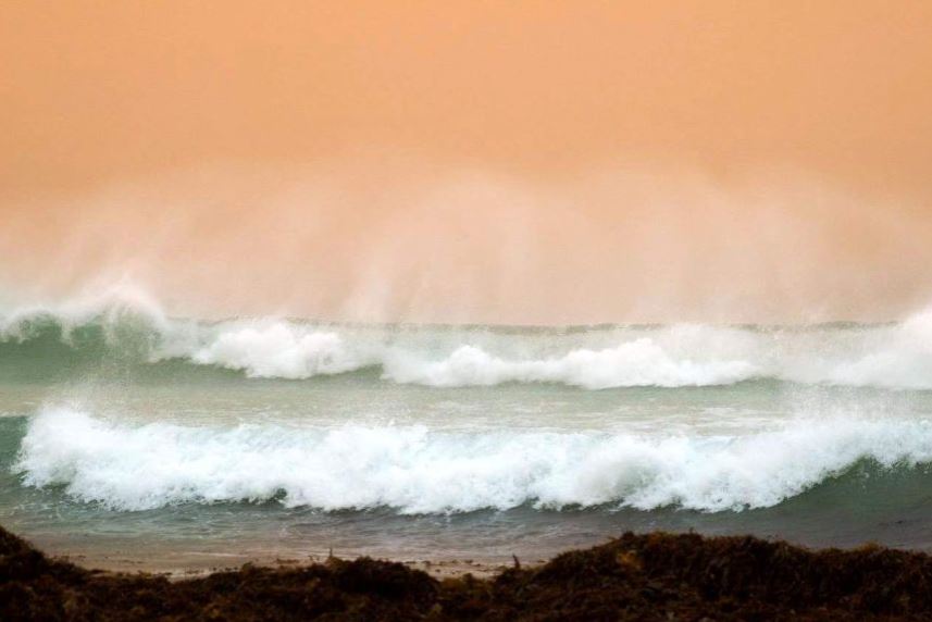
Image 1: Dusty waves off Geraldton, Sunday afternoon. Image via Maria Isaac

Image 2: Bedford, suburb of inner city Perth hit hard. Image via Linny Tang
During Sunday and early Monday morning, Western Australia was punished as ex tropical cyclone Mangga merged with a cold front off the WA coast and rapidly intensified.
Widespread damaging to locally destructive winds gusts were recorded to 9am this morning, with numerous reports of downed trees and powerlines and damage to property. Geraldton, in the Central West, was one of these worst affected regions, with Bedford (inner city suburb of Perth) also seeing damage to property.
Cape Leeuwin picked up the strongest gust overnight, recording a 132km/h gust at 4:14am AWST. Cape Naturaliste recorded a 116km/h gust at 3:17am, 109km/h at Busselton Jetty, 111km/h at Rottnest Island, 102km/h at Garden Island Colpoys Point, 100km/h at North Walpole, 95km/h at Kalgoorlie Airport while Perth Airport recorded a gust to 83km/h at 7:05pm last night.
Widespread falls of 10-25mm fell across the Pilbara, Gascoyne, Central and Lower West, with heavier falls of 20-50mm across the South West Forecast District. Steep Point in the Gascoyne region registered the highest rainfall total to 9am this morning with 80mm, Learmonth Airport scoring 60mm, Margaret River picking up 54mm, Duggans 52mm, Harman South 51mm.
It wasn't just the rain and wind that affected WA over the last 24 hours, with numerous watch and act fires flaring up ahead of the incoming system, with dry conditions and strong northerly winds. These winds also produced dust storms across the Geraldton region.
More than 60,000 homes and businesses are still without power this morning, with 44,000 of those homes and businesses situated in the Perth Metropolitan area. More than 300 calls were made to emergency services overnight.
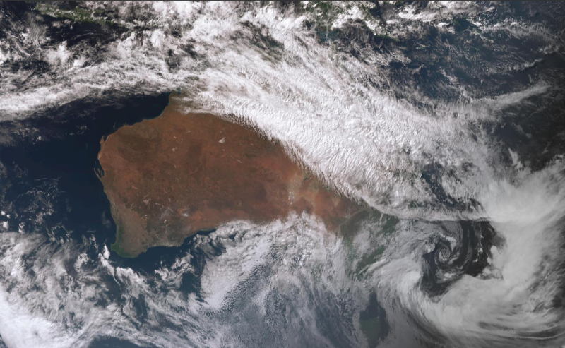
Image 1: Satellite Image of Australia showing the East Coast Low of the NSW Central Coast and the thick cloudband over the nation's north (Source: Bureau of Meteorology)
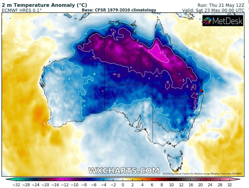
Image 2: Forecast Temperature Anomoly for Australia for Saturday 23 May, 2020
A dynamic weather setup over northern and eastern Australia is causing unseasonably cold conditions to grip parts of the country, with some areas seeing their coldest May days in decades.
An east coast low developed off the New South Wales Coast last night (helping drive heavy rainfall over the Central NSW coast and snow over the NSW Central Tablelands), a thick northwest cloudband is stretching across the north of the country.
While the Indian and Pacific Oceans are feeding these systems with moisture, a very cold upper level airmass is helping amplify them further, helping the low spin up off the coast and causing more widespread rain and thicker cloud across the north of the country.
The tropical Queensland coast was drenched early to mid this week, with some of the heaviest rain in decades as more than 300mm fell in 24 hours in some areas, and 48 hour totals above 400-500mm. Overnight, heavy rain and small hail hit the Sydney areas, Blue Mountains and Illawarra, with widespread falls of 20-40mm, including 83mm at Tomerong Creek (just west of Jervis Bay). The airmass got cold enough for snow above about 800 metres, with up to 10cm of snow reported about the Oberon Plateau, and a few centimetres reported around Blackheath and Katoomba.
Elsewhere, rainfall has been less substantial, however the thick cloud has been putting a sharp lid on temperatures. Yesterday, Tennant Creek (NT) and Kununurra (WA) had their coldest May day since 1979. Today, Katherine is on track to see its coldest May day since 1959, while Tennant Creek has been even colder than yesterday (reaching just 14.5 so far), also putting it on track for the coldest May day since 1959.
Further south, Brisbane has reached just 17.9 degrees so far today, currently on track to see its coldest May day since 1990, whilst Longreach has struggled to just 14.5 degrees so far today, currently the coldest May on record at the present site (51 years).
Temperatures will stay cold tomorrow for many areas, with places such as Brisbane, Townsville and Mackay only struggling into the mid-to-high teens. Charters Towers (14 degrees) and Georgetown (18 degrees) are forecast to see their coldest May day on record.
The thick cloudband will clear offshore on Sunday, causing temperatures to warm closer to normal although they are expected to remain cooler than average into early-to-mid next week.
Image 1: Satellite Image of Australia showing the East Coast Low of the NSW Central Coast and the thick cloudband over the nation's north (Source: Bureau of Meteorology)
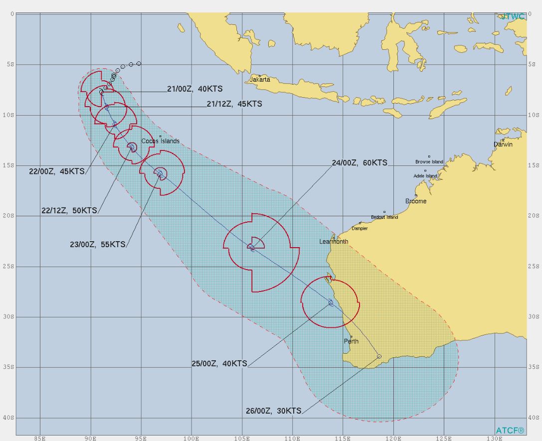
Image 1: Projected tack, via Joint Typhoon Warning Center
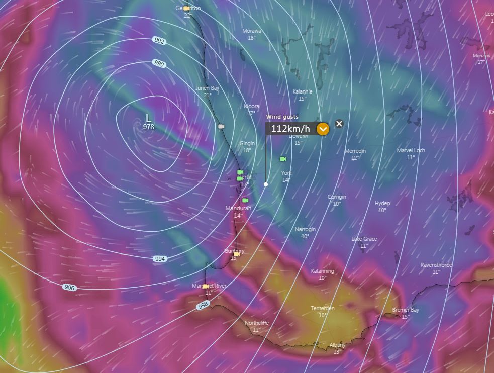
Image 2: EC wind gusts, Sunday night 24/05/2020/ Image via windy.com
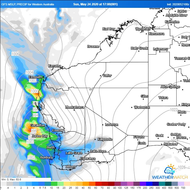
Image 3: GFS MSLP, Sunday night 24/05/2020. Image via WeatherWatch MetCentre
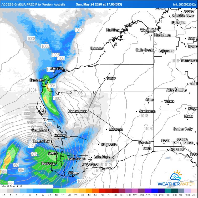
Image 4: ACCESS G MSLP, Sunday night 24/05/2020. Image via WeatherWatch MetCentre
Late into the weekend, a low pressure system is expected to move across the Western Australian coastline with cyclonic conditions.
This afternoon, a tropical low is situated northwest of Western Australia, near the Cocos Islands, and will steadily move in a southeasterly direction while intensifying over the next 48 hours.
Whilst this system has a low chance of developing into a tropical cyclone, the low is expected to undergo a transformation into a extratropical cyclone (otherwise known as a mid-latitude cyclone).
At this stage, the low is likely to merge with an approaching cold front, dragging tropical moisture down from the Indian Ocean. This will lead to widespread rainfall across the western half of the state, with locally heavy falls of up to 100mm, along with potential for damaging winds gusts up to and exceeding 100km/h.
Some uncertainty still exists with the timing and intensity of this system, but widespread falls of 10-20mm are expected from Sunday into Monday.
In the wake of this system, cold and blustery southwesterly winds are expected, with further shower activity continuing into middle of the week.
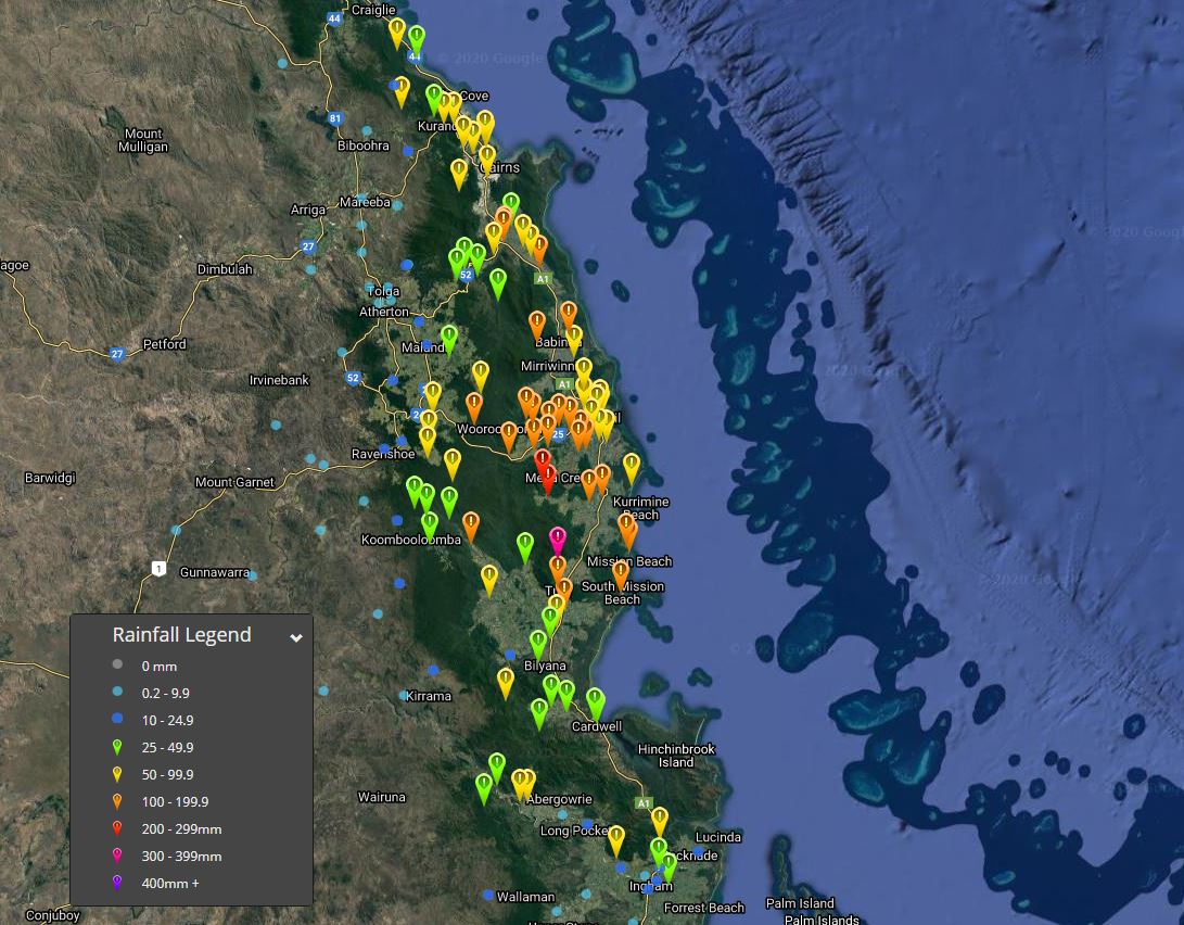
Image 1: EWN 24 hour rainfall totals to 9am 20/05/2020
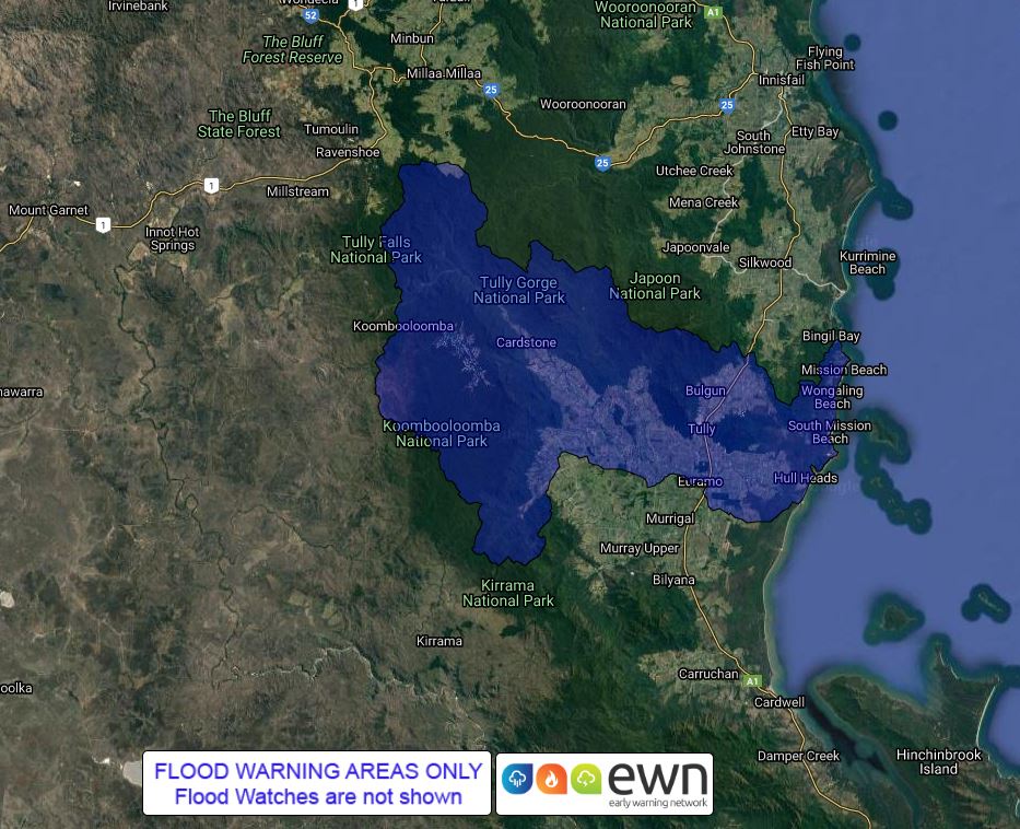
Image 1: EWN generated flood map. Tully river, valid 20/05/2020
Heavy winter rainfall has been recorded across North Queensland over the last 24 hours, with falls in excess of 200mm recorded for some locations.
A moist easterly onshore flow from a high in the Tasman Sea is combining with an amplifying upper trough across central Australia to generate a large cloud band (otherwise known as a northwest cloud band) across central and northern Australia.
This has led to heavy falls across the North Tropical Coast, with Bulgan Creek picking up a staggering 339mm in the last 24 hours. Tully picked up an impressive 174mm to 9am this morning, making this its wettest single May day since 1973 when it registered 192.8mm.
Other notable falls to 9am this morning include, Rankin Creek 169mm, The Boulders 181mm, Bingil Bay 152mm, South Johnstone 143mm and Cairns Airport 82mm.
This cloud band will continue to generate widespread showers, rain periods and isolated thunderstorms over the coming days, with humid onshore winds enhancing heavy showers across the Tropical North Coast.
Further moderate to locally heavy falls are expected, with some locations likely to see accumulated rainfall totals of 100-150mm over the next 48 hours. This may lead to localised flash flooding, and riverine flooding. A minor flood warning is current for the Tully River.
Under this cloud band, maximum daytime temperatures are expected to remain well below average, with some locations expected to see temperatures up to 10°C below the May average, with the potential for records to be broken.
Townsville is expecting a maximum temperature of 19°C on Saturday, with a May average of 27.7°C. Georgetown in the Goldfields region is expecting just 18°C on Saturday, with a May average of 30.4°C, meanwhile Charters Towers is expected to reach only 14°C on Saturday. Should this occur, it will be more than 13°C below the monthly average and be a record low maximum temperature for May.
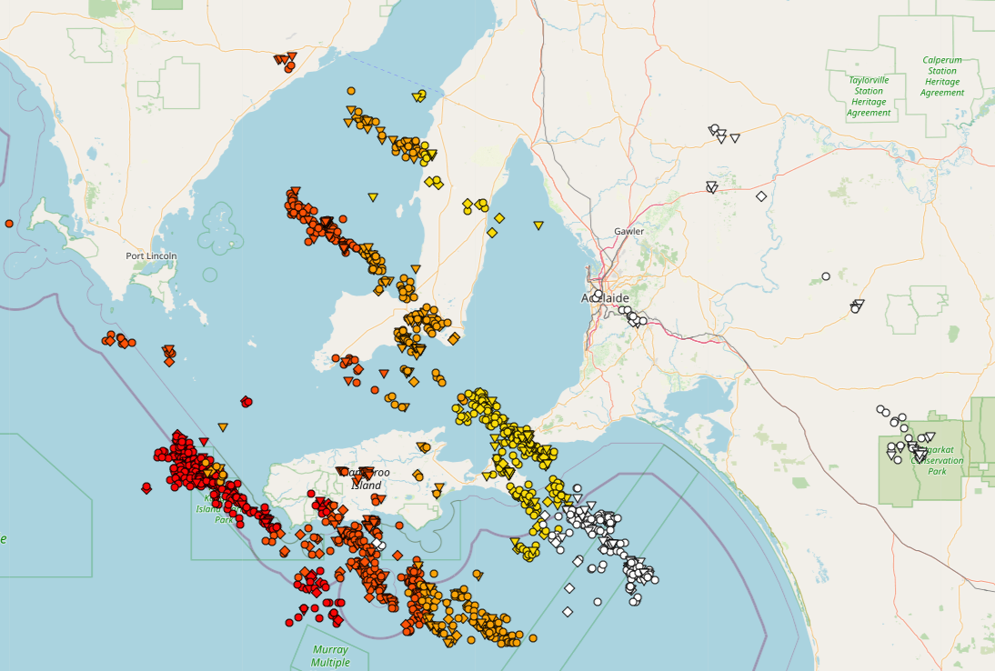
Image 1: Adelaide and surrounds GIS Lightning Data. EWN. Adelaide, SA. May 19/20, 2020.
A secondary cold front is expected through parts of southern and southeastern SA today after a wild night of thunderstorm activity across a vast portion southeastern Australia.
Due to the quick moving nature of the thunderstorm activity last night, these delivered very small rainfall totals, with some containing hail with very modest wind gusts.
The Adelaide Airport recorded a peak gust of 50km/h from the southwest at 1:03am this morning. Hindmarsh Island recorded the highest gust for the Adelaide and Mount Lofty Ranges region with 59km/h at 12:36am.
A broad mass of cold air from the Southern Ocean will succeed the cold front across the rest of southeastern Australia, effectively increasing the potential for hail and snow today and into tomorrow for elevated regions, along with a noticeable drop in daytime temperatures into this coming weekend.
Image 1: Severe thunderstorms stretch across central Victoria shortly after midnight. GIS Lightning Data. EWN. May 19th/20th, 2020.
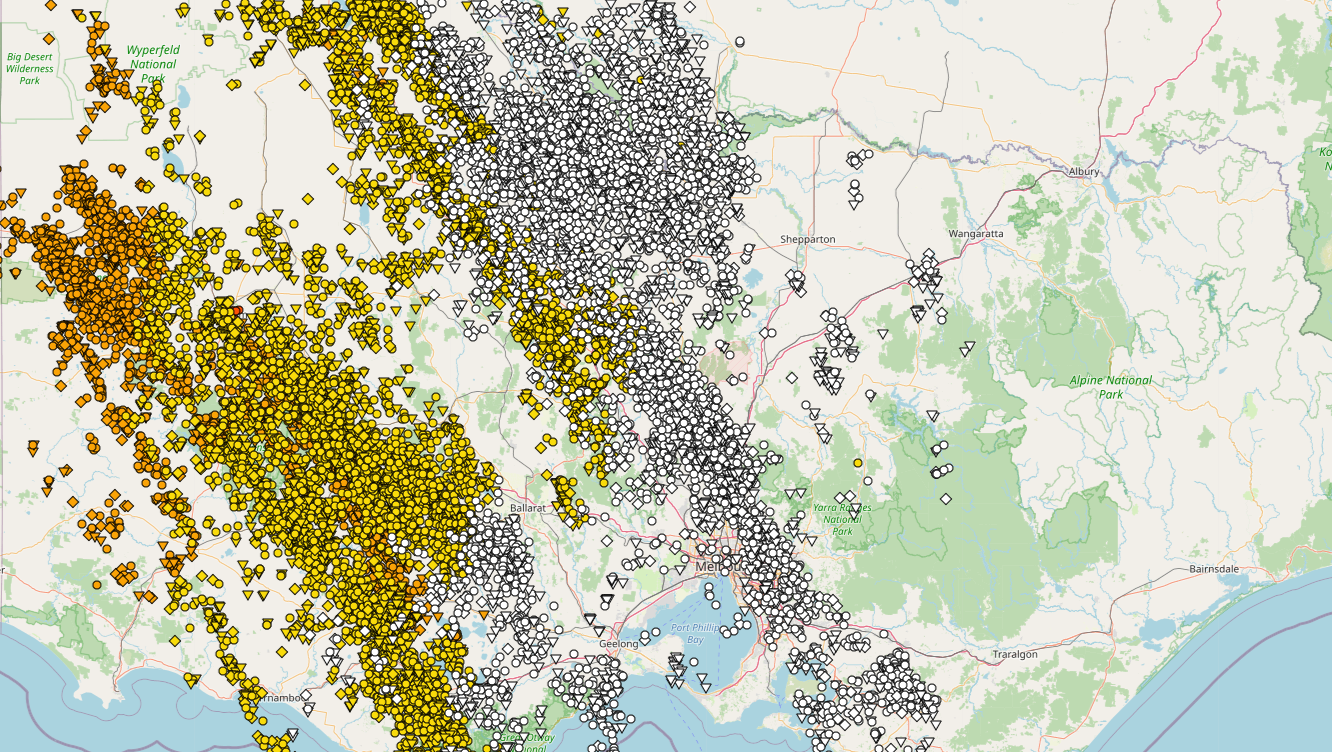
A strong cold front sweeping across the state last night produced squally thunderstorms through most parts of the state, passing through the central region into the early hours and producing damaging winds, hail and very frequent lightning.
15.6mm of rainfall was recorded at Melbourne's Olympic Park with slightly higher rainfall totals recorded for the eastern suburbs with Narre Warren North receiving 25mm, with Springvale West at Mile Creek recording 27mm.
Ballarat recorded a peak wind gust of 98km/h at 12:27am succeeding the peak gust shortly thereafter at Kilmore Gap which recorded a gust of 87km/h at 1:10am Strong to localised damaging winds also have continued to be recorded this morning with Halls Creek gusting to 135km/h, sustained between 8:07am to 8:10am.
The VIC SES received 130 calls for assistance last night, with some residences and building damage sustained through the Geelong, Waurn Ponds and Mount Duneed areas. More than 16 homes in Ironbark Street, Waurn Ponds were structurally damaged with fallen debris and collapsed roofs and debris strewn across some residences.
Much cooler temperatures are expected in wake of the cold front today, with a secondary cold front expected later tonight and overnight into Thursday, bringing the potential for additional light showers and snowfalls down to approximately 1000m tomorrow night, especially for northern and northeastern parts. The risk of severe thunderstorms along the secondary front is considered very low in contrast to last nights even for Victoria.
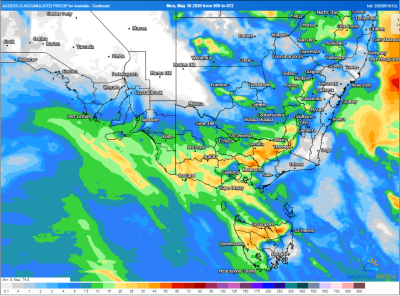
Image 1: Accumulated precipitation across southeastern Australia over the next 72 hours from the ACCESSG Model (Source: Weatherwatch Metcentre)
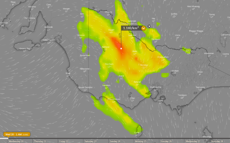
Image 2: Thunderstorm forecast at 1am Wednesday 20 May, 2020
Two frontal systems are set to bring the run of stunning sunny days to an end over southeastern Australia, with rain and thunderstorms set to develop from this afternoon, before a burst of showers, small hail and snow on Wednesday and Thursday.
The first of these fronts is crossing southeastern South Australia this afternoon and will spread east across Victoria and Tasmania into this evening and overnight, and is producing rain and thunderstorms on its boundary. Strong wind shear associated with the system will mean thunderstorms will move quickly and have potential to become severe, bringing the threat of damaging wind gusts and heavy rainfall.
This system will bring widespread falls of 1-5mm, however parts of northern VIC, central and northern VIC and far southern NSW will see heavier falls of 5-10mm with heavier totals of 15-30mm possible across northern TAS and the VIC and NSW alpine areas.
Winds are also expected to strengthen ahead of this front, particularly about alpine areas. Gusts may reach 90-100km/h about elevated areas of VIC (such as the Grampians and VIC Alps) and the NSW Snowy Mountains from this evening and into Wednesday morning, before easing.
The second front will spread across the southeast from Wednesday afternoon and evening, and push into NSW on Thursday. This front will be associated with significantly less thunderstorm activity, but will produce more good falls, especially over southeast SA, southwest VIC and western and northern TAS, where widespread falls of 10-30mm are likely.
A very cold airmass will also be associated with this front, with snow developing over alpine parts of VIC and NSW, and possibly spread up to the central NSW ranges on Thursday. Over lower lying areas, small hail is possible with any showers.
As this very cold airmass moves over NSW it will potentially cause an East Coast Low to develop off the coast. For more information on this event go to http://www.ewn.com.au/news/weather-news-2020-05-18.aspx
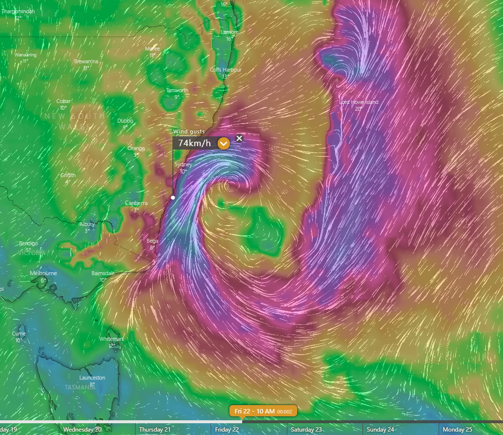
Image 1: Wind gust speeds and direction forecast by the EC model for Friday morning (Source: Windy.com)
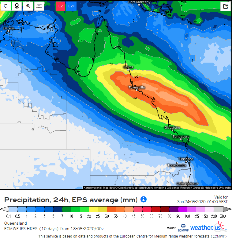
Image 2: Rainfall forecast by the EC ensemble for the 24 hours between 1am Friday and 1am Saturday (Source: weather.us).
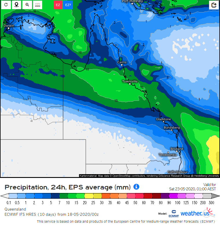
Image 3: Rainfall forecast by the EC ensemble for the 24 hours between 1am Saturday and 1am Sunday (Source: weather.us).
Off the southern NSW coast, a significant low should start deepening in the Tasman Sea by Friday before wandering around erratically in the area for a few days. This general area of low pressure is also likely to develop multiple centres which pivot around the main centre.
At this stage it's anticipated that just some gusty winds around 50 to 70km/h with localised higher gusts, large surf and some showers will develop along the southern half of the coast during this time, however if any strong low pressure centres come closer to the coast, stronger damaging winds exceeding 90km/h and heavier rain accumulations exceeding 90mm anywhere along the coast to their south would become more likely in this scenario.
While the possibility of another low developing near Southeast QLD and northeast NSW with moderate to heavy rain and strong winds also can't be completely ruled out yet, this is currently considered just an outside chance of happening.
A band of some showers and brief patchy rain is also likely to move across parts of eastern NSW and southern QLD on Wednesday and Thursday ahead of the front extending out of the developing low. Some snowfalls are also possible in the NSW and VIC alpine area as well as the southern NSW Tablelands in the colder south to southwesterly flow on the rear flank of the low.
Across VIC and southern NSW, very cold temperatures aloft in associated with a cut-off low will generate a strongly unstable environment. Scattered to widespread thunderstorms are expected during the afternoon and evening, with damaging winds, heavy rainfall and large hail.
Meanwhile parts of inland, central and north Queensland look set to shiver towards the end of the week and weekend with a few days of unseasonably cool to cold conditions especially during the daytime caused by a large cloudband and some rainfall streaming across northern Australia. This is a result of moisture aloft streaming across from waters to the northwest of Australia and being lifted by an upper trough.
Maximum temperatures are likely to be up to 10 to 15 degrees below average during that period with many towns in central parts only getting up to the mid teens on Saturday before slowly becoming milder again. The associated rainfall is currently forecast to eventually start focusing on northeast QLD on Friday, peaking around Saturday before moving off the coast on Sunday but this timing is subject to some change. The current expectation is for total rainfall amounts to average around 20 to 70mm for northeast QLD with some locally higher totals, however only a small shift in the focus of the better rainfall could make the difference between this area getting much less or more rainfall than currently forecast.
During most of the days leading up to Friday, a small strip of the North Tropical Coast and hinterlands as well as the northwestern Herbert coast are also likely to receive persistent onshore shower activity which may cause five-day accumulations to eventually reach 50 to 100mm with locally higher amounts. Some northern parts of WA and the NT are also likely to experience these colder conditions under the cloud cover and patchy rainfall associated with the same system.
Across VIC and southern NSW, very cold temperatures aloft in associated with a cut-off low will generate a strongly unstable environment. Scattered to widespread thunderstorms are expected during the afternoon and evening, with damaging winds, heavy rainfall and large hail.
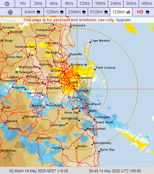
Image 1: Doppler Weather Radar - Brisbane 128km Winds - Thursday afternoon and evening, May 14th, 2020.
Waterspouts are tornadoes that form over a body of water, or move from land to water. Spouts often have the same characteristics as a tornado on land, and can be associated with severe thunderstorms. In the case of yesterday, these were considered non-supercellular as they originated from weak thunderstorm activity.
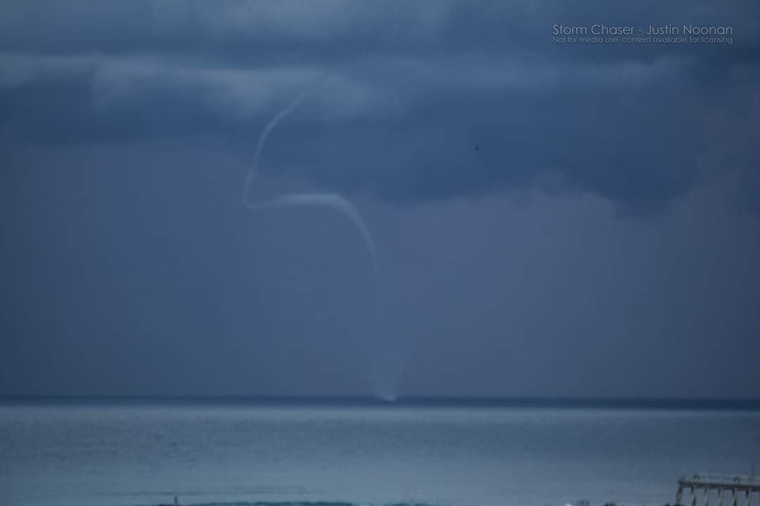
Image 2: Spectacular waterspout off the Tweed Coast as captured by EWN's Justin Noonan on Thursday, May 14th, 2020.

Image 3: EWN's very own Michael Bath captured this amazing lightning scene from isolated thunderstorm activity yesterday through the Northern Rivers during Thursday, May 14th, 2020.
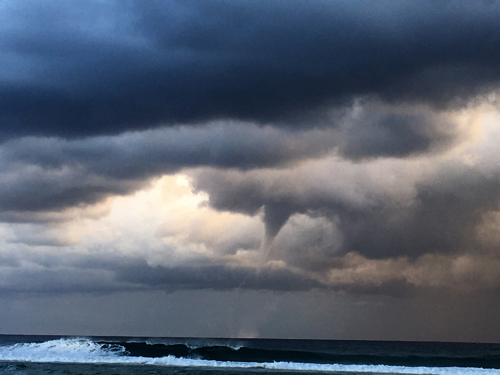
Image 4: Touchdown! Ben McBurney captures this v-shaped waterspout off Cabarita Beach, Northern NSW yesterday, Thursday, 14th May, 2020.
Waterspout vision via Storm Chaser Justin Noonan.
A spectacular sight occurred off the Southern Gold Coast and Northern New South Wales coasts yesterday afternoon as up to five waterspouts were filmed and reported, along with weak thunderstorm activity with some containing small hail.
This weather phenomena was due to a broad upper level trough bringing overall unstable conditions, modest surface boundaries and coupled with warm sea surface temperatures. One waterspout reported yesterday lasted up to ten minutes in duration and lofted spray from the ocean surface a considerable distance from the base.
Did you know? While tornadic waterspouts develop downward in a thunderstorm, a fair weather waterspout develops on the surface of the water and works its way upward. By the time the funnel is visible, a fair weather waterspout is near maturity. Fair weather waterspouts form in light wind conditions so they normally move very little. Added to this, the average waterspout is also considered to be 50 metres in diameter with wind speeds up to 80 kilometres per hour.
Across VIC and southern NSW, very cold temperatures aloft in associated with a cut-off low will generate a strongly unstable environment. Scattered to widespread thunderstorms are expected during the afternoon and evening, with damaging winds, heavy rainfall and large hail.
Early Warning Network team members Ben McBurney photographed waterspout events from Cabarita Beach, Northern NSW yesterday whilst team member Justin Noonan filmed some amazing waterspout footage from the Tweed Coast near Coolangatta. Added to this was also EWN's own Michael Bath who captured this fantastic lightning scene from McLeans Ridges (near Lismore) in Northern NSW.
Image 1: Forecast temperature anomoly at 4am Local Time Friday 15th May, 2020 (Source: wxcharts.com)
Image 2: Meteye Frost forecast for southeastern Australia at 4am Local Time Friday 15th May, 2020 (Source: Bureau of Meteorology)
A large and slow moving region of high pressure will lead to a stunning run of sunny late autumn weather for the southeast into early next week, however overnight temperatures will be among the coldest seen so far this year for many areas with widespread fog and frost expected across the region.
A number of locations had their coldest morning of the year today, including -2.8 degrees at Fingal, -0.2 degrees at Launceston, 6.6 degrees in Melbourne CBD, 2.5 degrees at Mildura, 0.1 degrees at Horsham, -4.9 degrees at Mt Baw Baw (just 0.1c shy of its May record) and -1.2 degrees at Ballarat.
Tonight will be another cold one across the southeast and for many areas will be even colder than what was felt last night, as cool daytime temperatures give way to even clearer skies (than last night) tonight. Some notable centres likely to experience their coldest (or close to the coldest) nights of the year so far include: Melbourne 5 degrees, Adelaide 7 degrees, Bright 1 degree, Canberra 0 degrees and Perisher -5 degrees.
Whilst cloud traps incoming radiation (and leads to cooler days), it also absorbs the infrared radiation emitted from the earth's surface, slowing the rate at which temperatures fall at night time. Hence cool daytime temperatures, followed by a clear night (particularly if there is low humidity, as water vapour is the most potent greenhouse gas), is a recipe for widespread frosts.
With the high likely to linger around into early next week (leading to prolonged clear skies), similar conditions are expected for the next several days. Differences in overnight temperatures will depend on local effects (such as wind and cloud), however most areas will see temperatures remaining below average. Those over inland areas are much more likely to experience fog and frost, with only localised locations (particularly in valleys) likely to see frosts closer to the coast.
A strong front is likely to arrive from mid next week, bringing with it a burst of showers, snow, wind and small hail.
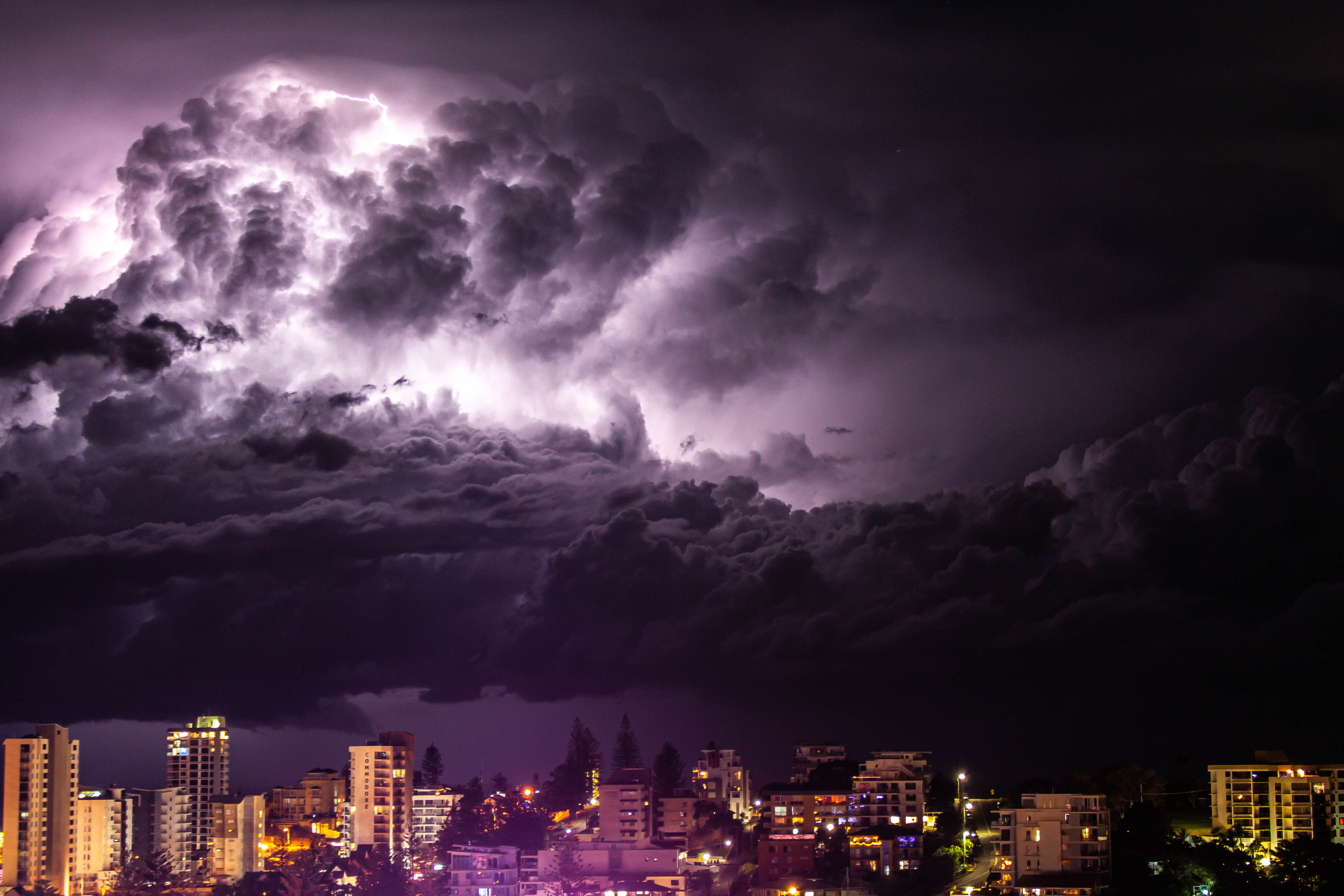
Image 1: Lightning active storms off the southern Gold Coast late last night. Photo taken by Justin Noonan.
The second week of May is expected to be relatively quiet on the weather front across the country, as a large high pressure system traverses southern Australia.
This large high (1033 hectopascals) will produce sunny skies and light winds across a large portion of central and southern Australia during this week. This high will lead to cooler nights and frosts for large parts of VIC/NSW/SA/TAS/southern QLD.
Cooler south to southeasterly winds will spread across the interior of the country, keeping maximum and minimum temperatures just below average.
A few showers may develop for exposed coastal locations across the northern NSW and QLD coast later this week, as a ridge becomes established.
Overnight, a southerly change moved up the northern NSW/QLD border region, producing isolated thunderstorms off the coast. These cells produced a lovely lightning display off the southern Gold Coast region late last night.
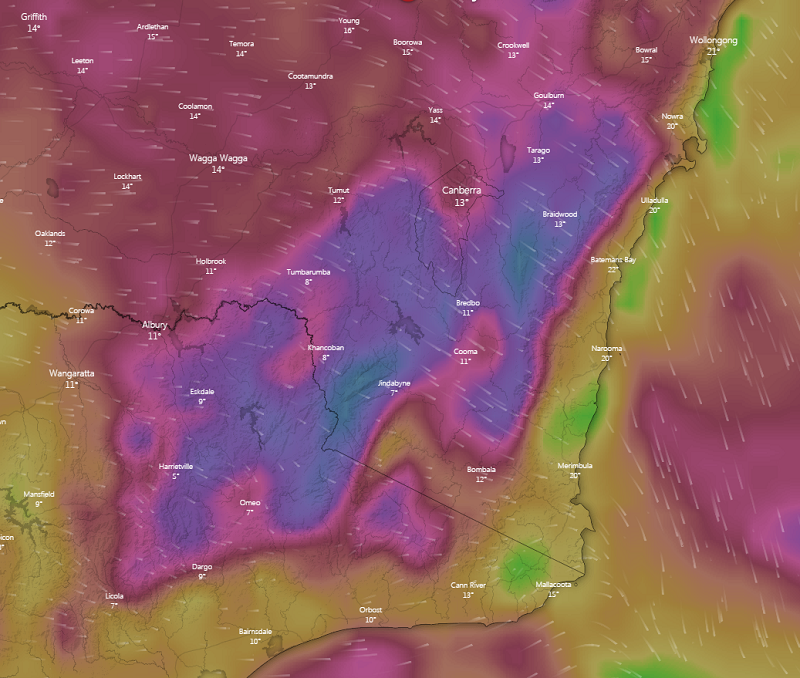
Image 1: Strong to gusty winds for Southern NSW at 16:00, Saturday, May 9th 2020 via Windy.com
A strong cold front will continue to sweep across most of New South Wales today and into far northeastern regions of the state tomorrow, with cold temperatures expected through western, southern and central regions post-change.
A Severe Weather Warning is current for damaging winds for people situated within the Snowy Mountains and ACT forecast districts of NSW, where winds gusts may reach or exceed 90km/h for these areas with gusts to 120km/h likely, especially about elevated terrain. Scattered tending isolated showers and thunderstorms are also likely to continue across the vast majority of New South Wales today with exception to the far southeast, far northeast and far western regions.
Thunderstorm activity is expected to become more active during the afternoon and early evening where some thunderstorms may have the potential to become severe for the elements of localised damaging winds and large hail, with more scattered activity through parts of the NW Slopes and Plains, Northern Tablelands, Hunter and Mid North Coast regions expected. Gusty winds may also occur about parts of the Hunter and Northern Slopes and Plains later in the day and into the evening. Isolated thunderstorms are also expected about the far northeast of VIC where localised damaging winds may occur. An 89km/h wind gust was recorded at Albury Airport thunderstorm at 12:43pm this afternoon from an isolated thunderstorm.
Thredbo Top Station recorded a peak wind gust of 117km/h at 12:09am overnight with sustained wind gusts over 100km/h recorded since 8:00am this morning, Saturday May 9th 2020. Slightly more modest wind gusts were recorded at Mount Hotham in northeastern Victoria overnight and into this morning, with peak wind gusts reaching 89km/h at 10:30am and 10:33am respectively, with an accompanying chilly 1.6°C temperature. Thredbo Top Station did also see some snowfall overnight, with more expected into this evening lowering to 1200m in elevation.
A Severe Weather Warning also continues for damaging winds for people situated within the East Gippsland, North East and West and South Gippsland forecast districts today with strong northerly winds expected to continue over the eastern ranges today before easing slightly into tomorrow. Localised strong wind gusts may occur with isolated shower activity tomorrow, with the slight chance of small hail occurrences.
Sheep Grazier Warnings are current for the entire state of VIC for cold temperatures, showers and westerly winds today contracting into southern districts tomorrow. A Sheep Graziers Warning is also current for the South West Slopes of NSW where cold temperatures, showers and gusty winds are expected especially about elevated regions of the Snowy Mountains.
Looking ahead into Sunday and Monday, a high pressure system is expected to develop near the Great Australian Bight tomorrow extending a high pressure ridge across northern VIC and southern NSW during Monday, making way for the onset of cool and dry conditions. Morning fog patches and frosts are set to return for inland regions with partly cloudy conditions, isolated showers and light to moderate winds into early next week.
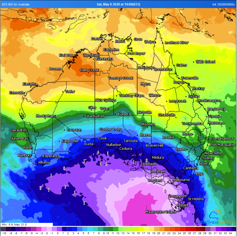
Image 1: Temperature contrast across southeastern Australia on Saturday 9th May, 2020 showing the frontal boundary (Source: Weatherwatch Metcentre)
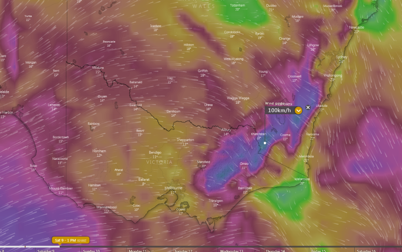
Image 2: Strong wind gusts forecast across northeast VIC and southeast NSW on Saturday 9th May, 2020 (Source: Windy)
It's been a balmy end to the working week for many parts of the southeast, however temperatures will plummet from tomorrow as a cold front sweeps across the southeast.
Sydney rose to 28.5 degrees today (Friday 8th May), more than eight degrees above average for May. This was the warmest it has been this late in autumn since 2012, and just the fourth time on record it has been this late in the season since records began in 1859.
Other parts of eastern and northern New South Wales and eastern Victoria also soared more than five degrees above average, including 26.5 degrees at Ulladulla (7.4 degrees above average) and 26.3 degrees at Nowra (6.7 degrees above average).
Saturday will be a volatile day across the southeast, as a cold front surges across South Australia, Victoria, Tasmania and southern NSW, whilst warm weather and possible thunderstorms affect the remainder of NSW. Wind gusts of around 100km/h are expected to affect the alpine areas of NSW and VIC ahead of the front.
Melbourne is expected to reach just 14 degrees, Hobart 13 degrees and Adelaide 16 degrees as the front sweeps through in the early hours of Saturday morning. Thunderstorms may develop on and in the wake of the front, although these are likely to be brief and short-lived. However, the very cold airmass associated with the system may cause small hail in any showers and storms, whilst any precipitation is expected to fall above 900 metres as snow in southern NSW/VIC and 700 metres in TAS.
Meanwhile Sydney is expected to reach 27 degrees on Saturday, again well above the May average. Further north, Brisbane will reach 27 degrees on Saturday, and 29 degrees on Sunday. The clashing airmasses will cause showers and storms to develop across the state, particularly over the central and northern inland.
As the change sweeps through the remainder of the southeast by Sunday, temperatures will become much cooler. Sydney will reach just 19 degrees in Sydney and 13 degrees in Canberra (followed by an overnight low of below freezing). Whilst it will warm to 29 degrees in Brisbane, a cooler change will arrive by the evening, dropping maximum temperatures to the low 20s the following days.
A high will cause settled conditions throughout next week with temperatures trending close to average.

Image 1: A tree falls on a car due to wild winds lashing southwestern WA (Source: ABC News https://www.abc.net.au/news/2020-05-05/wa-hit-by-storm-packing-gale-force-winds/12216764)
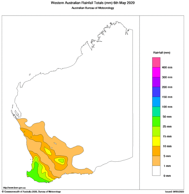
Image 2: Rainfall totals across Western Australia in the 24 hours to 9am 6 May, 2020
Wild weather hit southwestern parts of Western Australia on Tuesday afternoon and evening and into Wednesday morning, bringing down trees and powerlines and causing widespread power outages, as well as rainfall totals reaching close to 100mm.
The front was the second in a series of strong cold fronts to batter the region in the past few days, with the system first felt over the far southwest late Tuesday morning. The remainder of the region felt the strongest part of the front during Tuesday afternoon and evening and into the early hours of Wednesday morning.
Winds were strong enough to bring down trees and powerlines, some falling onto cars and property. There have been hundreds of calls to emergency services for assistance, and 55,000 homes were left without power.
Automatic Weather Stations gave a clear picture of just how strong the winds were, with some of the notable gusts including 128km/h at Cape Naturaliste and Cape Leeuwin, 118km/h at Busselton Jetty, 113km/h at Rottnest Island, 104km/h at Katanning, 102km/h at Mandurah and 102km/h at Garden Island. Wind gusts in excess of 120km/h are considered 'destructive'.
Heavy rain also hit some areas, with widespread falls over the southwest of 20-30mm, although these got lighter quickly further east and north with Perth only recording 9.2mm in the 24 hours to 9am this morning. However, Garden Island just southwest of Perth reported 99.8mm, its heaviest May fall in the site's history (15 years). Other notable falls included 42mm at Albany, 37mm at Dwellingup and 44m at Margaret River.
Very cold air in the wake of the front will cause these showers to persist over the southwest today, with the risk of brief 'cold air' thunderstorms which may also be associated with small hail and squally wind gusts. Wind gusts independent of thunderstorms will reach 80-100km/h today between Lancelin and Cocklebiddy, inland to about Hyden, although the strongest winds will be confined to the coast.
Another weaker front will cause some showers to the far southwest tomorrow, before a high will cause more settled weather over the weekend.
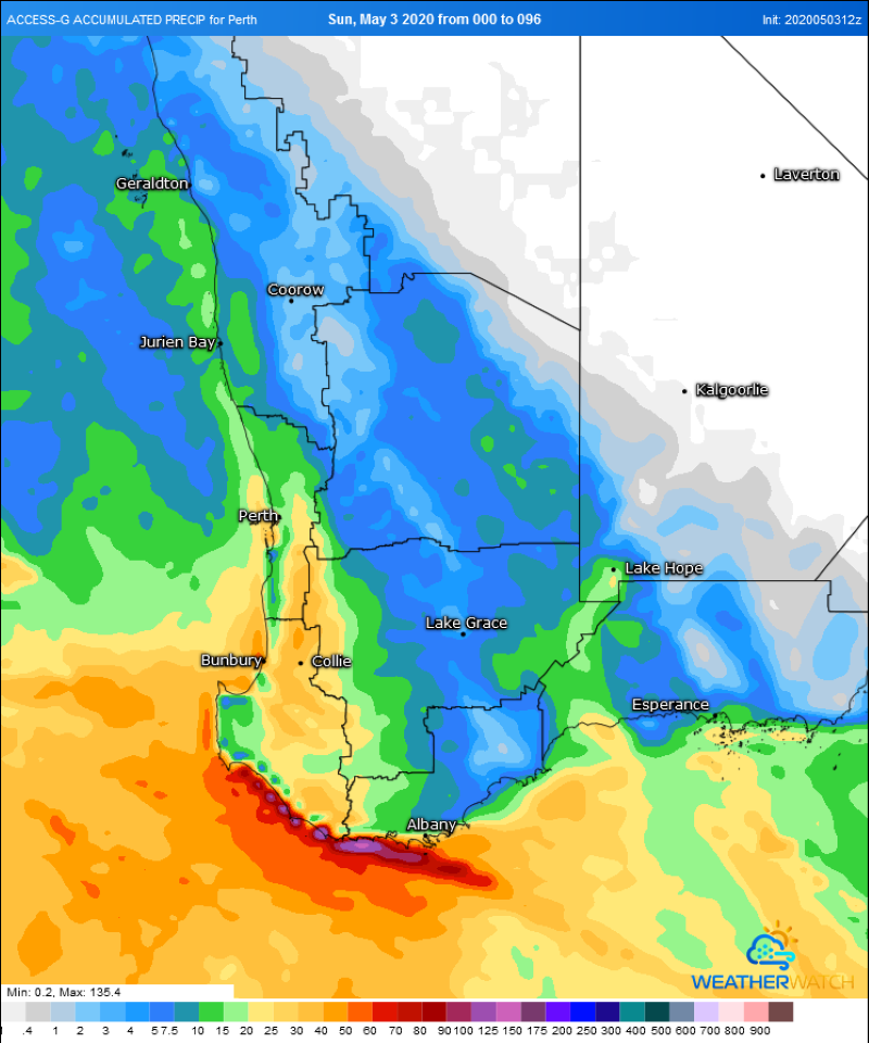
Image 1: 850mb temperatures across western Australia on Wednesday 6th May showing the temperature gradient over the state (Source: Weatherwatch MetCentre)
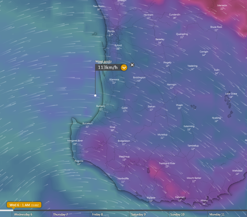
Image 2: Estimated wind gusts on Tuesday 5th May evening/Wednesday 6th May morning across southwest WA (Source: Windy.com)
Image 3: Rainfall accumulation over the southwest of the state (Source: Weatherwatch Metcentre)
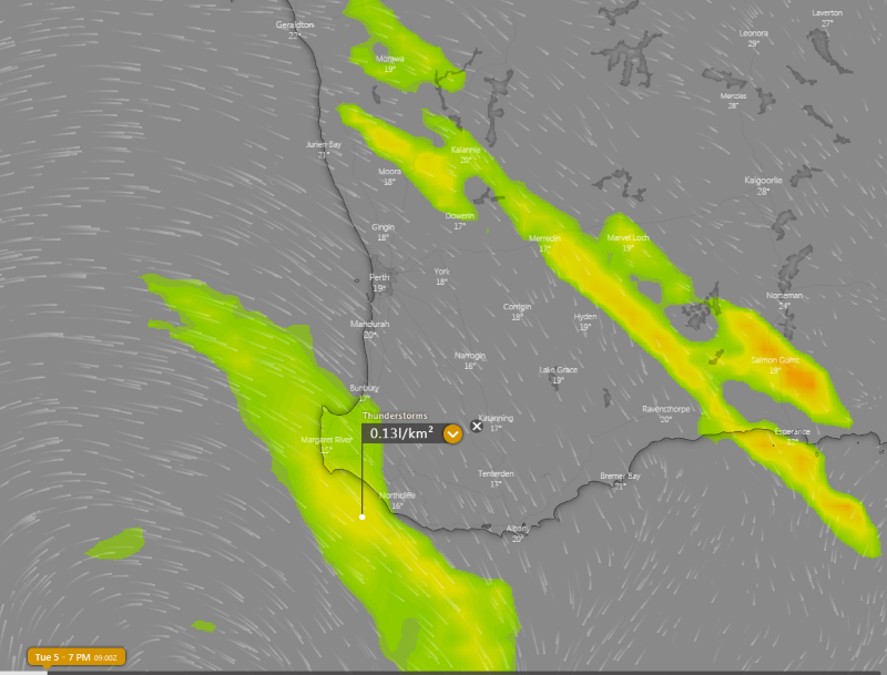
Image 4: Thunderstorm forecast from ECMWF Model on Tuesday 5th May, 2020 afternoon (Source: Windy)
The balmy conditions that kicked off May will quickly turn to wet and windy weather today and persist into Tuesday and Wednesday as two strong cold fronts batter the South West Land Division.
As of 11am Western Standard Time, the first of these fronts was making its way over the South West district, and will spread throughout the Lower West and western parts of the South Coastal and Great Southern districts during the afternoon.
Showers and isolated thunderstorms just ahead of and associated with the frontal boundary may produce damaging winds with peak gusts up to 100km/h. Winds independent of showers and storms not expected to reach severe criteria, easing from the west in the wake of the front. Widespread falls of 5-10mm are likely, with isolated falls in excess of 20-30mm.
A more significant front will hit the region on Tuesday and into Wednesday, impacting the far southwest by late Tuesday morning, before spreading throughout large parts of the South West Land Division (including Perth) by Tuesday afternoon and evening, reaching South East Coastal areas on Wednesday.
Widespread wind gusts to 90-100km/h (independent of thunderstorms) are likely with the system, with the strongest gusts likely to impact coastal areas between Lancelin and Israelite Bay, although gusts up to 80km/h may extend as far inland as Kalgoorlie. More exposed areas may see gusts up to 110km/h.
Thunderstorms ahead of and with the system are also possible, although these will be isolated. During Tuesday morning and afternoon, storms are most likely on a line from Esperance to Geraldton, with a secondary band of storms possible over southwest coastal areas on Tuesday evening and into Wednesday morning. Thunderstorms over the southwest coastal areas will be associated with very cold upper level temperatures, and may bring squally winds and small hail.
Widespread falls of 5-10mm are again likely, although heavier totals in excess of 20mm are possible near thunderstorms. Over the far southwest coast, localised falls in excess of 30mm are possible.
Another weaker frontal system will brush the far southern coasts on Thursday, however a large high pushing in is expected to keep this front from having too much of an impact apart from a few showers. This high will cause settled conditions to return on Friday and into the weekend.
Image 1: National Temperature Maximum Forecast Map
Image 1: Lightning photo taken from Springwood, QLD from storms late on Monday 23 February, 2021...
Image 1. Access R forecast rainfall 8am Wednesday 1st August. Image 2. EC wind gusts 10am 1st...