Weather News Archive 2018 August
How to prepare for bushfire season
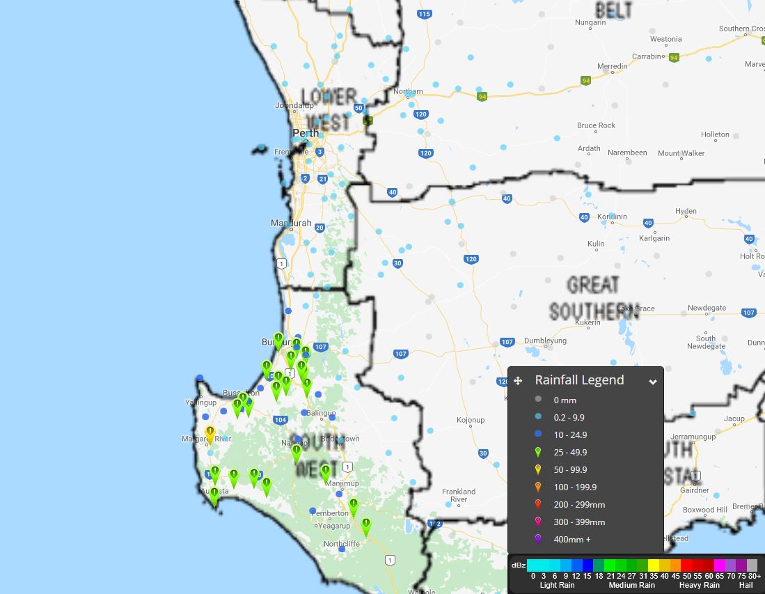
30th August 2018
Spring is upon us which means the warmer...
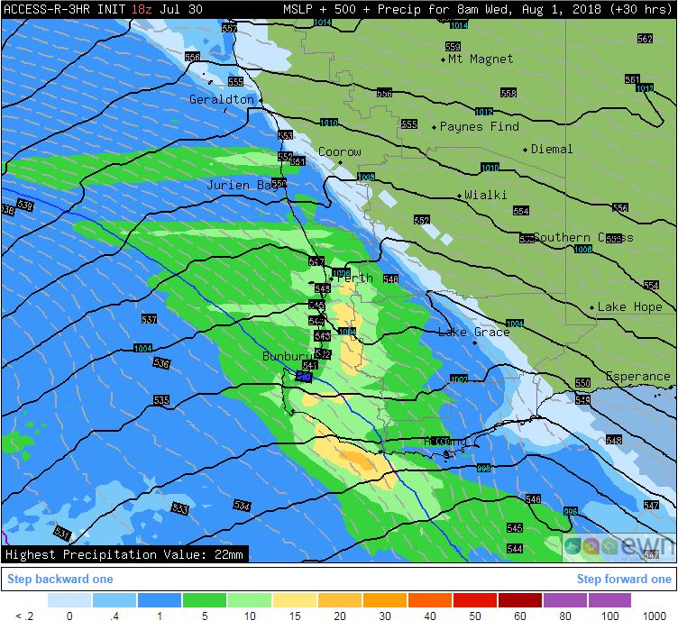
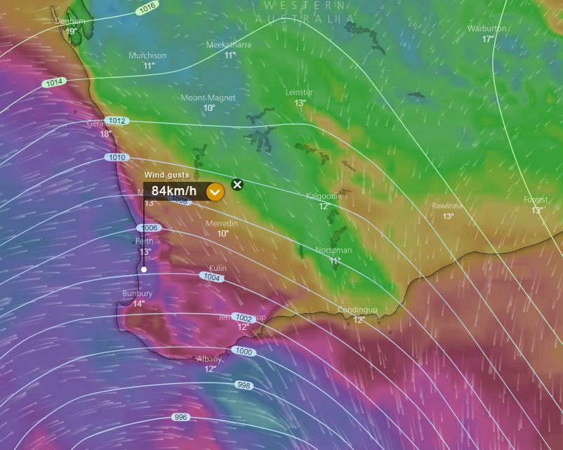
Image 1. Access R forecast rainfall 8am Wednesday 1st August. Image 2. EC wind gusts 10am 1st August windy.com
A strong cold front and associated trough will move through south-western parts of WA on Wednesday, with heavy rain periods, damaging winds and thunderstorms.
A large band of showers, rain periods and isolated thunderstorms are expected to move through with the initial front during the morning hours. Localised damaging wind gusts of up to 100km/h are possible for exposed coastal locations and elevated terrain.
Very cold upper level temperatures associated with a strong upper trough will move across the region during Wednesday. This will enhance the potential for small hail, particularly with any storm activity. Light snow flurries may also develop for higher terrain in the Stirling Ranges overnight Wednesday into Thursday morning.
Moderate falls are expected with the passage of the front during Wednesday, with widespread falls of 15-30mm. Isolated heavier falls of up to 50mm will be possible, particularly with any storm activity.
During Thursday, gusty south-westerly winds, widespread showers and isolated storms are expected to continue, however conditions should gradually ease into the evening.
A secondary front will move north across the region during late Friday and Saturday with a return of heavy showers, squally winds and isolated thunderstorm activity, and the chance of further flurries on the Stirling Ranges.
Image: Forecast cloud cover from the ECMWF model at 4am EST (around the time of the eclipse). Source: Windy
Australians will be treated to the longest total lunar eclipse of the 21st century tomorrow morning, part of a thrilling astronomical double as it coincides with Mars' closest approach in 15 years.
Those that missed the lunar eclipse earlier in the year (where many missed out due to cloud) will get another chance to catch the unique spectacle, although some parts of the country will still have to battle with potential cloud cover.
In a rare astronomical double, Mars will also be located very close to the moon and will appear larger than normal as it makes its closest approach in 15 years.
The only drawback is those that want to catch the event will have to get up relatively early in the morning - on a weekend - and look towards the west.
Brisbane and Sydney will see totality begin at 5:30am EST with the moon to set in both cities before totality finishes.
Whilst this will cut the length of time down slightly, it will provide the optical illusion of the moon appearing larger than normal as it sets on the western horizon.
Other capital cities in the country will be able to see totality over its entire duration:
Melbourne - 5:30am to 7:14am
Hobart - 5:30am to 7:14am
Adelaide - 5:00am to 6:44am
Darwin - 5:00am to 6:44am
Perth - 3:30am to 5:14am
Remember, unlike a solar eclipse, lunar eclipses can be seen safely with the naked eye or binoculars.
Lunar eclipses occur when the moon passes entirely in the earth's shadow (umbra), blocking it from direct sunlight. Sunlight that is refracted through the earth's atmosphere gives the moon its red colour, instead of it appearing entirely black.
The next total lunar eclipse in Australia won't be until 2021, so be sure to get out and have a look if you get the chance.
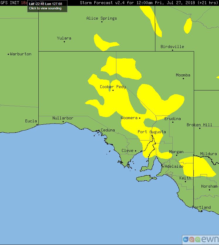
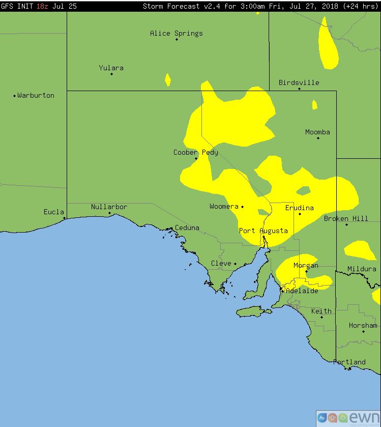
Image 1, Access R 3 hour total precipitation. Image 2 and 3, GFS storm potential overnight Thursday into Friday.
A low pressure system and upper cold pool of air is expected to track in a north-easterly direction across central and eastern parts of SA this afternoon and overnight, with showers, light rain periods and isolated gusty thunderstorms.
Very cold temperatures in the upper atmosphere are expected to provide weak instability for isolated thunderstorms during Thursday. Into the evening, a strengthening low-level jet is expected to help enhance high based thunderstorms across northern regions of the state where the potential will exist for localised damaging wind gusts.
Rainfall totals of less than 10mm are expected, however an isolated fall or two up to 20mm will be possible, particularly with any storm activity.
Conditions will gradually ease from the west overnight into Friday with fresh southerly winds moving into the region.
Image, rainfall totals to 9am, 26th July 2018
A low pressure system and strong cold front moved through the South West Land Division of Western Australia during Wednesday, producing strong to localised damaging wind gusts, chiefly across coastal locations and surrounding islands.
Winds were at their strongest during the afternoon and evening, with gusts reaching 96km/h at Garden Island, 89km/h at Rottnest Island, Melville Water and Ocean Reef, and 74km/h at Mandurah.
Moderate rainfall totals were also recorded with the passage of the front, with Glen Eagle receiving an impressive 55.4mm, Dwellingup 39.2mm, Mandurah with 33.6mm and Margaret River with 32mm.
Whilst mostly fine conditions returned during Thursday, showers are expected to redevelop across the region late Friday as a weak cold front clips the south-west of the state.
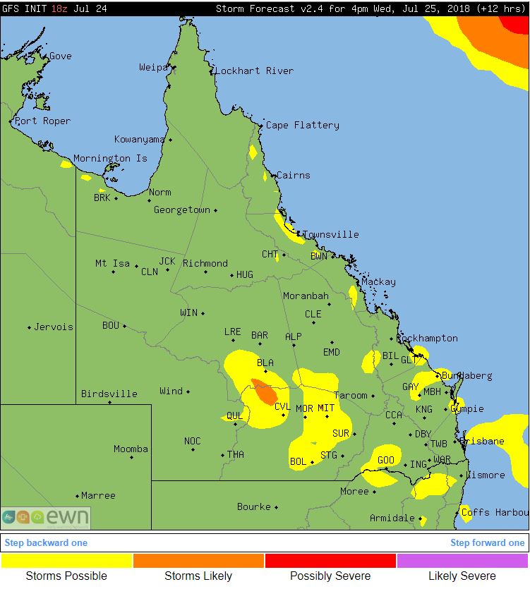
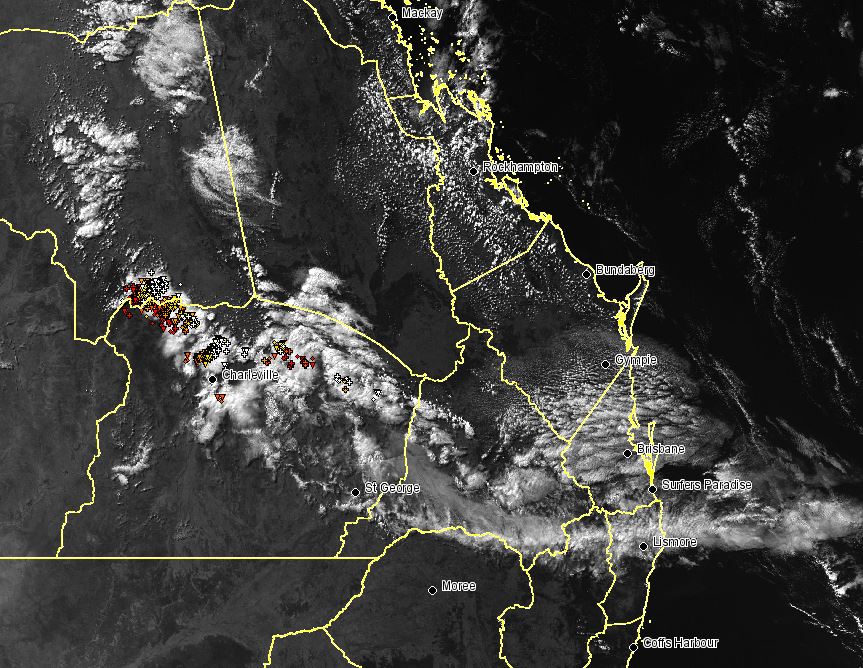
Image 1, GFS thunderstorm probabilities, QLD 4pm.
A large upper trough across Queensland led to unstable conditions through central and southern parts of the state on Wednesday, triggering showers and thunderstorms.
Isolated, tending scattered showers and thunderstorms developed in response to this feature across the Maranoa and Warrego region during the afternoon hours.
Sadly, rainfall totals remained generally light with Bakers Bend recording 10mm to 3pm, Dooloogarah 4.0mm and Joylands picking up 2.0mm.
Whilst Queensland isn't noted for its thunderstorm activity during the winter months, when strong upper troughs move across the region in combination with warm day time temperatures, thunderstorms activity becomes possible.
This system will begin to shift off the QLD coast overnight and during Thursday before another upper level system moves in from the west late this week and into the weekend, when another round of thunderstorms are likely to develop.
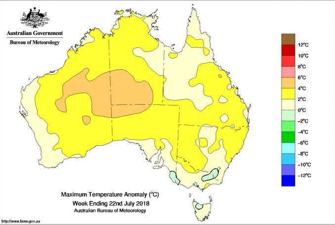
Image: Bureau of Meteorology Maximum Temperature Anomaly (°C), week ending 22nd July 2018
Parts of Australia are on track to register their warmest July days on record as persistent clear skies and a lack of strong cold fronts deprive the country.
Above average day time temperatures are continuing for large parts of central and eastern Australia as cold fronts struggle to reach as far north as normal for this time of the year. Warm north to north-westerly winds sourced from northern western Australia have been impacting parts of QLD, NSW, southern NT and parts of SA during July. This trend is expected to continue through to the weekend before dry south-westerly winds move in.
Alice Springs, Sydney, Newcastle and Brisbane are larger centres of note that are expected to break July records by the end of the week with a continuation of above average temperatures. Brisbane's average maximum temperature so far this month stands at 22.6c, above the long term average of 21.8c, and with a run of temperatures in the mid-20s expected until the end of the month, the record of 23.0c is likely to be broken.
Sydney's July maximum is averaging a balmy 19.2 degrees so far, well above the long-term average of 16.4c. With temperatures expected to hover around the 20-degree mark for the remainder of the month, the record of 19.5°C degrees looks to be under threat.
Whilst daytime temperatures have been well above average, night time temperatures in July have been the coldest in recent years in many areas. With the warmer than average daytime temperatures and very dry conditions, combined with very cold nights leading to severe frosts at times, this has been detrimental to farmers.
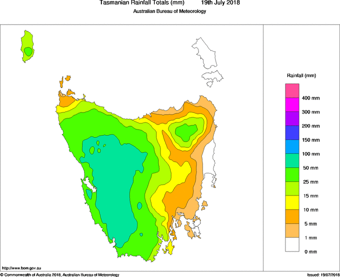
Image: Rainfall totals recorded to 9am today (19 July, 2018) across Tasmania (Bureau of Meteorology)
A vigorous cold front swept through Tasmania last night, bringing wind gusts in excess of 100km/h to some areas as well as heavy rainfall that led to flooding.
After a relatively pleasant (albeit) windy start to the start over the Apple Isle, conditions gradually soured as the day wore on as the second cold front in as many days hit the state.
Whilst strong winds characterised Tuesday's front, Wednesday's front brought with it widespread heavy rainfall over the western half of the state.
Strahan collected 33.2mm in the 24 hours to 9am, its heaviest rain since March, whilst Scotts Peak Dam registered 43.6mm, its best rain since November.
Over the highlands, even heavier totals were recorded, including 75mm at Cradle Valley, 78mm at Pine Forest Moor and 87mm at Lake Gwendy. These heavy falls resulted in mostly minor flooding across the region, although moderate flood levels have been recorded at the North Esk River.
Many areas also recorded strong and gusty winds in the 80-90km/h range, however only exposed areas registered wind gusts over 100km/h, including Maatsuyker Island (122km/h), Scotts Peak (113km/h) and Mount Read (104km/h).
Showers will persist for the remainder of the day and into tomorrow due to another front, before easing on the weekend.
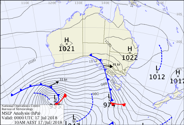
Image: Bureau of Meteorology Mean Sea Level Pressure (MSLP) Chart at 10am Tuesday 17th July, showing the cold front crossing southeastern Australia
The first in a series of cold fronts has been sweeping across South Australia, Victoria and Tasmania today, bringing wind gusts up to 145km/h at some locations, downing trees and powerlines and leaving many residents without power.
The effects were first felt in South Australia this morning as wind gusts clocked up to 117km/h in the Adelaide Hills, and 90-100km/h in and around Adelaide, causing more than 5000 homes to lose power.
By midday, winds had significantly strengthened over western Victoria, with gusts reaching 111km/h at Horsham, 102km/h at Nhill and 119km/h at Mount Gellibrand, bringing down trees and powerlines.
Further south in Tasmania, winds also reached dangerous speeds around midday, with gusts recorded as strong as 98km/h at Hobart and 145km/h at Mount Wellington.
Melbourne was hit by the front during the mid-to-late afternoon, accompanied by showers, thunderstorms and small hail. Widespread wind gusts of 80-90km/h were recorded across the metropolitan area and surrounds, with wind gusts reaching as strong as 126km/h in the Bay.
Strong winds were also felt in southern parts of NSW, although most places didn't record gusts above 90km/h (defined as 'damaging'), apart from alpine areas which saw gusts to 120km/h.
Winds will ease later this evening, however another front will cause another burst of strong winds tomorrow, particularly over Tasmania and southern areas of South Australia and Victoria.
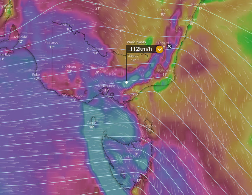
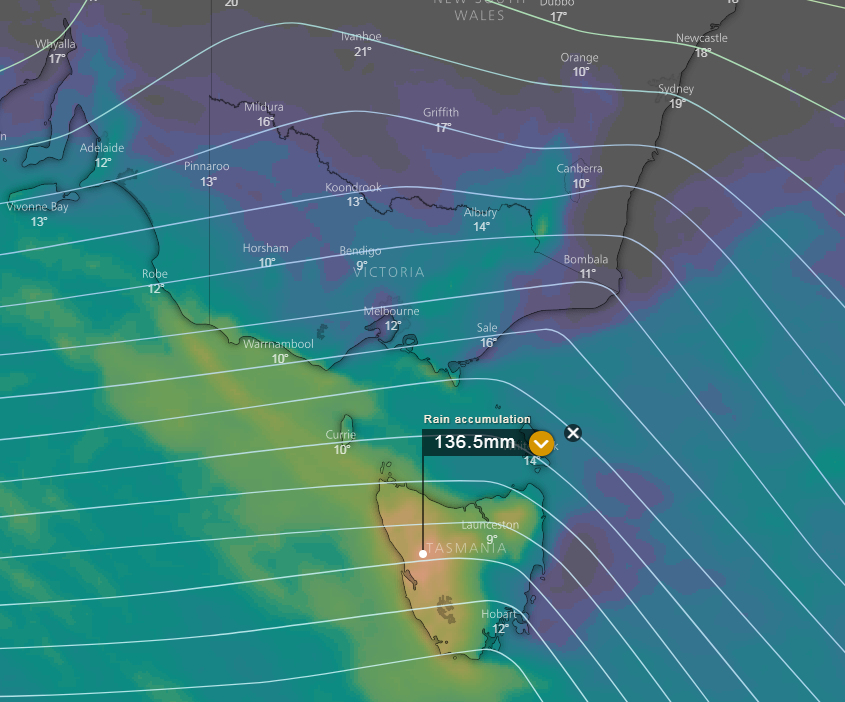
Image 1, EC surface wind gusts, 3pm Tuesday 17th July 2018. Image 2, EC 5 day accumulated rainfall totals. Images via windy.com
A series of cold fronts are expected to move across parts of South Australia, Victoria, New South Wales and Tasmania over the next several days.
During Tuesday, the first substantial front is likely to sweep across southern Australia with damaging north-westerly winds. Gusts of up to and exceeding 100km/h are possible, particularly across exposed coastal location and elevated terrain.
Heavy showers and isolated thunderstorms expected during Tuesday, with small hail being likely.
Behind this initial front, a burst of westerly winds is expected, before shifting back to the north-west ahead of a secondary front during Wednesday. This is likely to re-enforce strong to potentially damaging wind gusts to parts of eastern VIC, southern NSW and TAS late Wednesday and into Thursday. Heavy showers and isolated thunderstorms are likely, along with the potential for small hail.
Western parts of Tasmania are likely to see widespread falls of 20-60mm over the next 5 days with isolated heavy falls of up to and exceeding 100mm possible, which may lead to localised flash flooding, creek and river rises. Very cold temperatures are expected, particularly later into the week, has prompted numerous sheep grazier warnings for SA, TAS and VIC with the loss of livestock possible.
Snow is possible to elevations above 700m in western Tasmania over the next few days, while further snow falls of up to 30cm will be possible across the Alpine resorts in Victoria and southern NSW through to the end of the week.
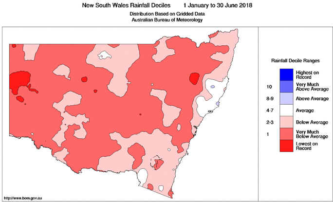
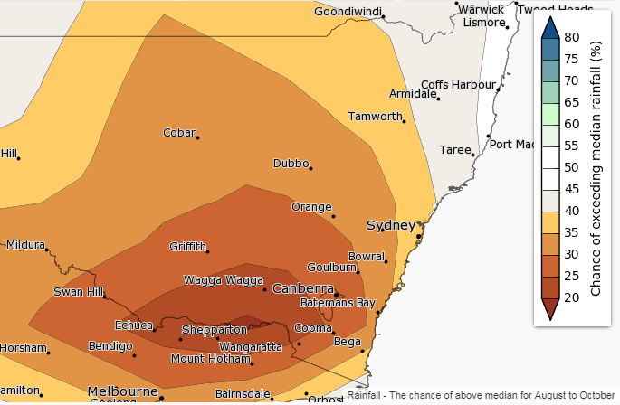
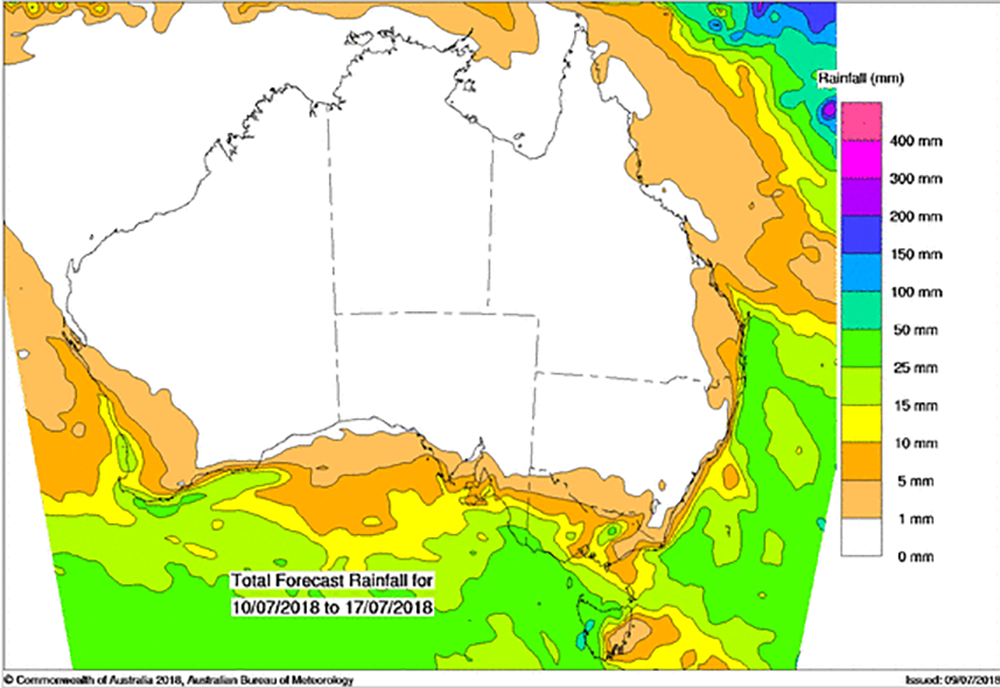
Image 1, 6 monthly deciles rainfall for NSW/ACT. Image 2, August to October rainfall outlook.
Drought conditions continue for many regions across New South Wales, with figures revealing some towns have experienced the least rainfall in recorded history for the January to June period.
Broken Hill and Cobar are having their driest start year on record with only 18.2mm falling in Broken Hill and 24.4mm in Cobar since the 1st of January 2018. Records go back to 1889 for Broken hill and 1902 in Cobar.
Wilcannia in western has received just 25.4mm to July 1st which makes it the driest start to a year since 1927 when they received just 19.2mm.
While the bulk of rainfall deficiencies have been recorded in NSW this year, several locations across southern QLD, northern VIC have seen their driest start for many years. Murravilly in western Victoria is having its driest year since 1911 when records began with just 50.8mm falling so far.
With no immediate rainfall expected, drier than average conditions are likely to extend through to October at least for many parts of NSW.
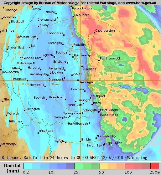
Image: Radar derived rainfall totals in the 24 hours to 9am, 12th July, 2018
There has been a lot of rain around southeast Queensland the last couple of days, but unfortunately the majority of this desperately needed substance has fallen offshore, with only the coastal fringe and islands collecting substantial totals.
Whilst cloudy conditions affected much of the region the last couple of days due to a low pressure trough, most areas collected only light totals, with widespread totals of 2-to-5mm inland to around Toowoomba, doing little to ease long term rainfall deficiencies.
Coastal areas (especially about the Sunshine Coast) and the islands fared better, with widespread falls of 50-to-80mm in the 24 hours to 9am today.
However, it could have been a completely different story had the trough that produced the rainfall been slightly further west, with radar signatures suggesting more than 150mm fell offshore.
Rainfall has cleared the region today as the trough moves further offshore, with dry conditions expected for at least the next week.
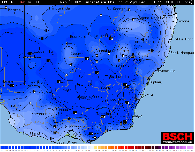
Image: Minimum temperatures to 9am today across NSW (11th July). Source: Brisbane Storm Chasers
After a relatively mild start to July when many areas experienced record early July warmth, the mercury has plunged across the state with some areas experiencing their coldest night in more than a decade.
A lingering cold airmass in the wake of a strong cold front that crossed during the weekend combined with clear skies and light winds last night, causing temperatures to fall below freezing in many areas.
Canberra dipped to -6.3 degrees, its coldest night of the year and more than six degrees below average, whilst Fowlers Gap in western NSW shivered through its coldest night since June 2006, dropping to-2.6 degrees.
Goulburn and Bombala both had their coldest night of the year as the mercury dived to -8 degrees.
Canberra is a chance to see some light flurries (mainly outside of the city) tomorrow morning as the cold pool crosses, with the higher parts of the central tablelands also a chance by the afternoon and evening.
As the cold pool reaches the central and southern NSW coast tomorrow afternoon (including Sydney), showers with possible small hail and localised thunder are likely to move in, causing temperatures to plummet into the low-to-mid teens by the time work finishes.
A high pressure system is likely to move in from Friday leading to clear skies and light winds, causing a return to frosty nights across large parts of the state.
Mostly fine conditions are likely across large portions of the country this week.
A low pressure system and a series of cold fronts moved across southern Australia late last week and across the weekend bringing snow, heavy rainfall for Tasmania, damaging winds and thunderstorms with small hail.
Behind this low, a large area of high pressure has moved into the region bring more settled conditions. Over the next few days, this high is likely to dominate the pattern across Australia, maintaining mostly fine conditions.
While an upper trough is likely to drift over Victoria and New South Wales mid-week, only weak instability will be present allowing for a few showers with small hail to develop. A few coastal showers are also possible across the southern QLD and northern NSW coastline as onshore winds develop across the region.
During the next several days, calmer conditions are likely to lead to widespread frosts across central and eastern Australia as minimum temperatures drop close to and below zero in some locations. This spells further bad news for drought stricken regions, with further follow up rainfall needed that fell during late June.
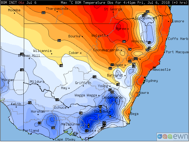
Observed maximum temperatures across NSW on Friday 6th July, 2018
Record early July warmth has hit NSW for a second day in a row in central and northern parts of the state, as temperatures pushed close to ten degrees above average.
Unusually warm northerly winds sourced from northwestern Australia have been affecting NSW ahead of a strong cold front, leading to temperatures more typical of early spring in normally the coldest part of the year.
Sydney reached 24.8 degrees today (on top of 25.3 degrees yesterday), making it the warmest pair of July days on record, with yesterday also being the warmest day recorded in the first week of July in 159 years of records.
Tamworth reached 23.9 degrees, its warmest July day this early in the month, and just 0.1 degrees shy of its all-time July record (records go back to 1957).
Conditions will be significantly cooler tomorrow as the front sweeps across the state, apart from the northeast corner which will see temperatures reaching the mid 20s.
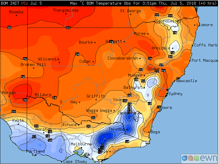
Observed maximum temperatures across NSW on Thursday 5th July, 2018
New South Wales is bathing in unseasonably warm mid-winter weather, with some areas experiencing their warmest day on record this early in July today.
Northerly winds ahead of a strong cold front (due to arrive this weekend) are dragging the airmass down from northern Australia, with temperatures soaring five to ten degrees above average across the state.
Lowland areas of the state have seen temperatures reaching the the low-to-mid 20s, whilst the tablelands have reached the mid-to-high teens, more typical of early spring than mid-winter.
Whilst no long term monthly records (longer than 30 years) have been broken, the warmth is especially unusual this early in July, with the coldest weeks of the year typically from the winter solstice through until mid-July. Sydney had its hottest day on record during the first week of July, reaching 25.2 degrees.
The warm airmass will continue to linger over the state tomorrow, especially over central-east and northeastern parts, where temperatures will reach the low-to-mid 20s again.
A strong cool change will push through from Saturday, causing much cooler conditions across NSW.
Source: Windy.com EC model. Accumulated rainfall totals next 5 days. Surface wind gusts 1pm Friday 6th July, accumulated rainfall totals next 5 days.
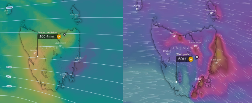
A strong low pressure system and a series of cold fronts are expected to move across TAS during Thursday and Friday.
Strong to potentially damaging wind gusts are likely to develop with the passage of the change during Thursday afternoon and into Friday, with strong north-westerly winds, turning westerly into Friday.
Thunderstorm activity is likely to approach the west coast late Thursday and overnight into Friday with the potential for a couple of storms to become severe with localised damaging wind gusts and small hail.
Widespread rainfall totals of 20-40mm are likely with isolated falls above 70mm possible which may lead to localised flash flooding and minor flooding for some locations.
Snow is expected on Friday on elevated terrain above 700m where 3 day accumulations of up to 30cm will be possible for Alpine regions.

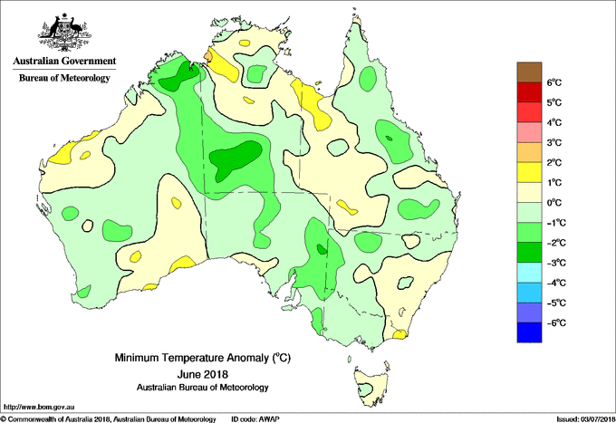
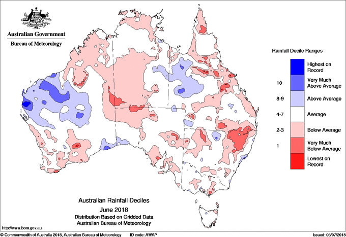
Anomaly charts of mean daily maximum, minimum temperatures and rainfall deciles for June 2018.
The Bureau of Meteorology has released its climate data for June. As a whole, June was warmer than average in Australia with a national monthly mean temperature 0.33 °C above average.
Day time maximum temperatures were warmer than average across Australia for June, with a national anomaly of +0.84 °C. Decile 10 mean monthly maximums temperatures (the warmest 10% of historical observations) were observed for parts of the North West Slopes and Plains of New South Wales, western Top End in the Northern Territory, Capricornia District in Queensland and scattered regions of the western Kimberley in Western Australia.
However, that national mean minimum temperature in Australia as a whole was 0.17 ºC below average for June. Minimum temperatures for the month were cooler than average across most of Victoria, western NSW, eastern South Australia, much of eastern QLD, the south-eastern Top End in the NT, a large region of southern NT and the eastern half of the Kimberley in WA.
Rainfall across the country was below average as a whole. Monthly rainfall was below average for the Kimberley and south-western quarter of WA, the majority of the NT, much of SA and eastern mainland states. June rainfall was very much below average (the lowest 10% of historical observations, decile 1) for some areas along the east coast of Australia, with the largest observed in the North West Slopes and Plains and Northern Tablelands districts inland of the Great Dividing Range in north-east NSW and Central East NSW.
A number of stations in New South Wales and Queensland received record low June rainfall, with quite a number more observing their lowest June rainfall for at least 20 years. June was a wetter than average month for the Pilbara, Gascoyne and parts of the Western Interior of WA, as well as the coastal Eucla District and a large portion of western QLD.
EWN rainfall map to 9am AWST
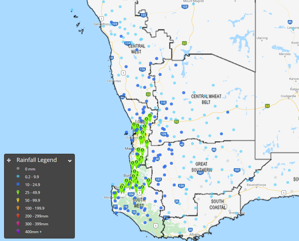
Moderate falls are beginning to develop across parts of WA this morning as a strong cold front moves across the region.
At present, a large rain band with widespread falls of 10-20mm have been recorded, with heavier falls in the 30-70mm range across the South West. While rainfall have generally been light across the Perth region this morning, more substantial activity is expected throughout Monday.
Heaviest falls to 9am this morning are: Margaret River 67mm, Beedelup 52mm and Milyeannup 45mm.
A gust of 106km/h was recorded at Cape Leeuwin at 3:22am Monday morning.
A SEVERE weather warning remains in effect for damaging winds and heavy rainfall that may lead to flash flooding over the next 24 hours.
Spring is upon us which means the warmer...
Image 1: Operational Consensus Forecast max air temperature for Saturday 28/11/2020. Image via...
Bureau of Meteorology rainfall forecast, Monday 2nd July 2018.