Wintery blast for Southeastern Australia this weekend
A significant cold front is expected to move across the Great Australian Bight as a high pressure...
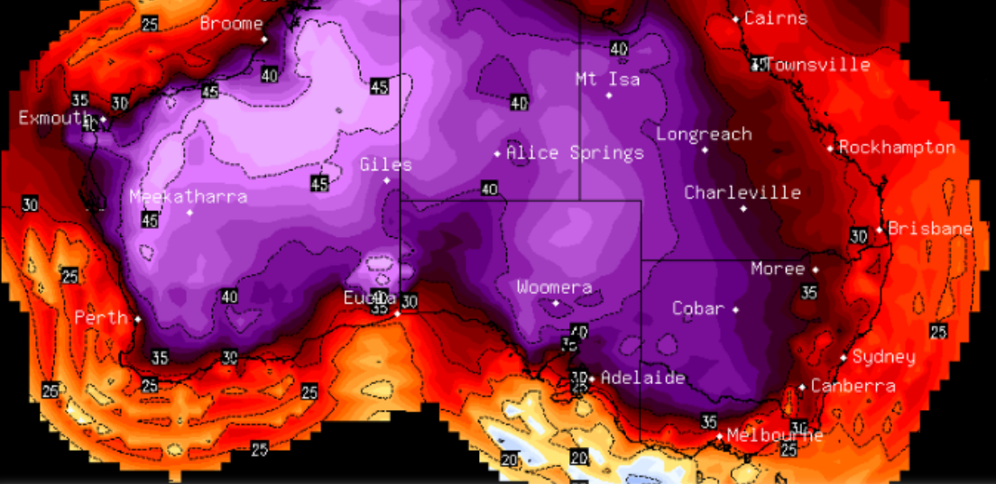
Image 1: National Temperature Maximum Forecast Map
The vast majority of Australia is set to scorch across the Christmas/New Year period as a heatwave grips the nation with records set to be challenged.
Inland areas have been sweltering already for more than a week, with northwest Australia enduring a continued run of temperatures in the mid-to-high 40s. Bourke also reached 47 degrees and Alice Springs fell just shy of its December record (44 degrees) mid last week.
This heat spilled south over the weekend in the west with Perth reaching 41 degrees on Saturday, and is now set to spread into the nation's southeast, where it is set to sit over the Chrismas and New year period and well into the first week of January.
While this will be great for holiday goers in coastal areas as the warm weather and sunny skies will make for great beach weather (and the heat will be tempered by seabreezes), as well as meaning that Christmas and New Years plans are unlikely to be washed out due to rain in most areas, inland areas are set to scorch with December records under threat, particularly for consecutive hot days.
Mildura is expected to hit 40 degrees on at least six consecutive days, eclipsing the previous record of five days in 1931, and will reach the mid 40s by the end of the month. By late December, many inland areas will see a continued run of temperatures in the low-to-mid 40s, with Alice Springs set to challenge its December record again on consecutive days.
Adelaide and Canberra will feel the worst brunt of the nation's capitals, with Canberra set to challenge its December record on multiple days, soaring into the high 30s by late this month. Adelaide will see heat in the mid 30s (including at least one day in the low 40s) into early January. Other capitals will be spared the worst heat due to either weak cold fronts or seabreezes with the hottest days limited to a couple of days or limited to the early 30s (as opposed to the 40s), although western Sydney will see consecutively hot days in the high 30s and early 40s
Gusty winds may also develop in some parts of the south after Christmas, bringing the increased risk of bushfires towards New Years.
With a positive Southern Annular Mode (which controls how far north cold fronts can reach), there is little relief in sight. There are some indications of cooling across the country around the second week of January as frontal activity and moisture increases, leading to increased cloud cover, however temperatures are still expected to remain above average.
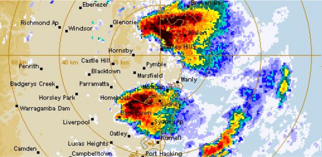
Image 1: Sydney Radar - Severe Hailstorms - 21st December 2018
Massive hail hit many parts of Sydney and the Central Coast yesterday as a number of supercell thunderstorms swept through the region, with the total damage bill from the event likely to be in the billions. Conditions were ripe for severe thunderstorm development, with temperatures pushing into the mid 30s and moisture levels similar to that of Darwin in the wet season, leading to huge amounts of available energy.
On top of this heat and humidity, there was very strong vertical wind shear available as moist onshore winds and a modified southeasterly change at the surface backed to strong westerly winds in the upper levels. This allowed for the updrafts to tilt and rotate, and combined with the massive amounts of energy available and also drier air in the upper atmosphere, produced very powerful updrafts capable of carrying massive hailstones.
After a sultry afternoon, the first cells stormed into the Sydney Basin from around 4pm, with the first of the supercells producing hail officially recorded to 8cm in the Liverpool and Casula areas at around 4:30pm, although by the time this cell reached the city hailstones were only reported as large as 2cm.
A secondary supercell quickly developed over Northern Sydney just after 4:30pm and rapidly intensified as it moved towards the Central Coast. 8cm hail in diameter was reported in the Berowra and Brooklyn areas from this storm, before it moved over the Central Coast causing hail as large as tennis balls at Woy Woy and golf balls at Gosford. Hail was large enough that it came in through the roof at Erina Fair, whilst many emerged from the area showing a spectacularly rotating storm.
A third supercell homed in on the city suburbs at around 6pm, producing the city's biggest hail since the 1999 hailstorm, with Rose Bay, Paddington and Surry Hills reporting hail 6-7cm in diameter.
At the same time, a fourth supercell was hitting the Camden to Cabramatta region, with hail reports of 6-8cm in diameter although photos indicate stones could have been even larger than this to softball size around Camden (unoffical 9-10cm).
Other multi-cellular cells then swept through Sydney, producing dangerous lightning and marble to golf ball size hail over the Blue Mountains and western Sydney including Penrith.
What was remarkable about this event was the spatial distribution of the hail across Sydney. In a typical large hail event, there would be no more than 1-2 supercells and the hail swathe would be in a relatively small area. This event saw a significant part of the Sydney Basin and Central Coast record big hail, which may mean the event could be the costliest since the 1999 hailstorm and will likely be at least in the billions.
The largest official hail at 8cm in diameter (although photos indicate larger hail) also makes it one of the largest hail sizes recorded in Sydney, although still smaller than a number of other events including the 1947 hailstorm,1999 hailstorm and December 2007 hailstorm.
The run of severe thunderstorms is over in the city, with cooler southeasterly winds likely for the next few days before hot and dry conditions develop over the Christmas and New Years period.
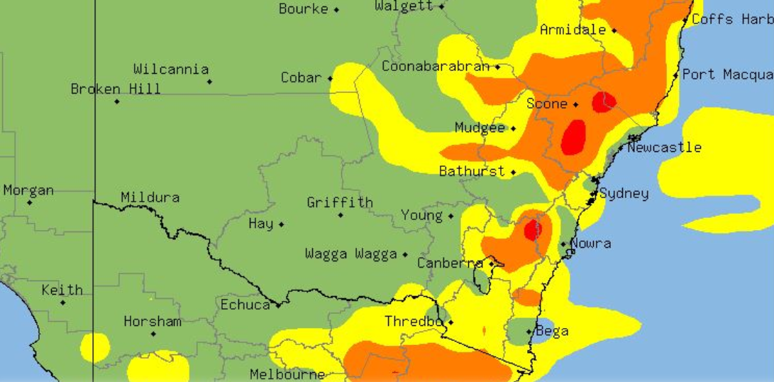
Image 1: NSW Thunderstorm Probability - 19th December 2018
After a brief lull in storm activity, thunderstorms are hitting large parts of New South Wales again this week, bringing the risk of damaging winds, heavy rainfall, large hail and frequent cloud-to-ground lightning.
Thunderstorms have fired up across southern and central areas this afternoon and will spread to some northern areas later, and are currently severe warned for damaging wind gusts and large hail.
With temperatures increasing and moisture levels decreasing a little, these thunderstorms are higher based than those seen on the weekend. This improves the chances of spectacular lightning displays and also enhances the risk of damaging wind gusts, however the risk of flash flooding and large hail is lower than on the weekend (but still a chance).
The cause of the thunderstorms is a broad low pressure trough lying across the state, being fed by moist onshore winds. This is a more typical setup for this time of the year, compared to the one that produced widespread severe thunderstorms from Thursday to Sunday last week.
Tomorrow, thunderstorms will again focus on more central areas (mainly the central east), but will also spread into some parts of the Northern Rivers.
On Friday and Saturday, thunderstorms will contract to the northeast of the state, before a gusty southeasterly change clears activity from the state by Sunday.
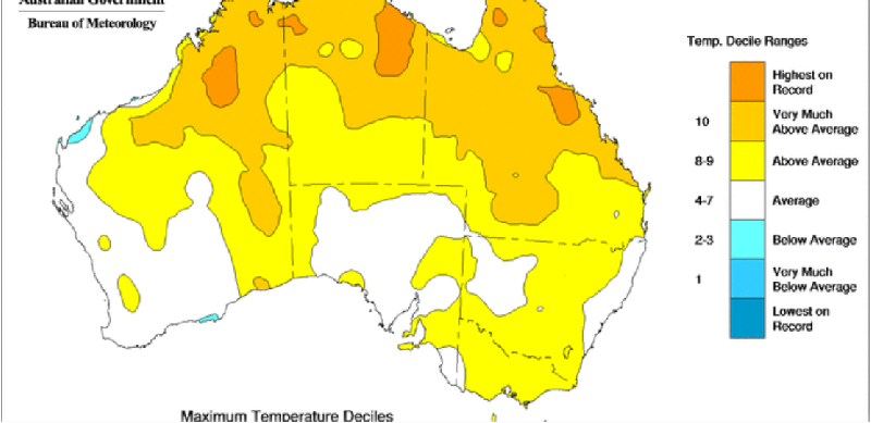
Image 1: National Maximum Temperature Deciles - December 8th, 2019
Spring in Australia was a mixed bag across the country and varied considerably from month to month, with spring rainfall close to average across the nation, even after enduring nationally the driest September on record, and temperatures remaining well above average.
After a September that had sustained high pressure and little rainfall, conditions improved considerably across October and November with above average rainfall experienced due to useful (although not drought breaking) rain events.
This rainfall did vary considerably however, with Victoria, western Tasmania and southwest Western Australia remaining very dry throughout the season. Meanwhile, parts of the the east coast, the interior and southern WA recorded a wetter than average spring, including the wettest on record for parts of WA's southeast inland.
Continuing the trend in recent years, temperatures were well above average throughout most of spring, with the nation recording its ninth-warmest on record. This was helped by fourth-warmest October on record, although September and November were also above average.
The heat was particularly pronounced in Queensland which saw its third-warmest spring on the back of the late November heatwaves, where numerous sites in central and northern parts of the state set records for monthly or annual high temperature and consecutive hot days by significant margins. This lead to more than a hundred blazes across Queensland, with a number of them becoming dangerous and leading to widespread damage.
Looking into summer, a hot and dry summer is expected for large parts of the country, although some parts of eastern Australia have a higher chance of seeing wetter than average conditions.
A significant cold front is expected to move across the Great Australian Bight as a high pressure...
Regions across the Northern Territory and Western Australia are currently facing significant...
Image 1: European Ensemble (ECWMF) via Windy. Peak wind gusts for Saturday - 11:00pm 30th May, 2020.