WA, SA, Tasmania, NSW, and Victoria will feel the wrath of severe weather this week
The blocking pattern, which has been responsible for the essentially unchanging weather across most...
A powerful cold front and pre-frontal trough will sweep across Western Australia on Wednesday, generating a large region of severe weather.
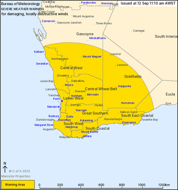
The Bureau of Meteorology has issued a Severe Weather Warning for damaging to locally destructive wind gusts across the South West Land Division in Western Australia, with gusts to 100km/h expected to develop during Wednesday 13 September with the passage of this cold front. A large swathe of winds extending from southern Gascoyne to the eastern Goldfields and Eucla forecast regions, will be affected, including Perth.
Whilst winds of this nature aren’t unusual for southwestern WA, the expected thunderstorm activity to accompany this particular front and trough is. Sheep Graziers are being warned that cold temperatures, showers, and strong southwesterly winds are expected on Wednesday, bringing an increased threat for loss of lambs and sheep in exposed conditions.
Severe thunderstorms are also expected to develop with this system as it passes across southern regions of Western Australia.
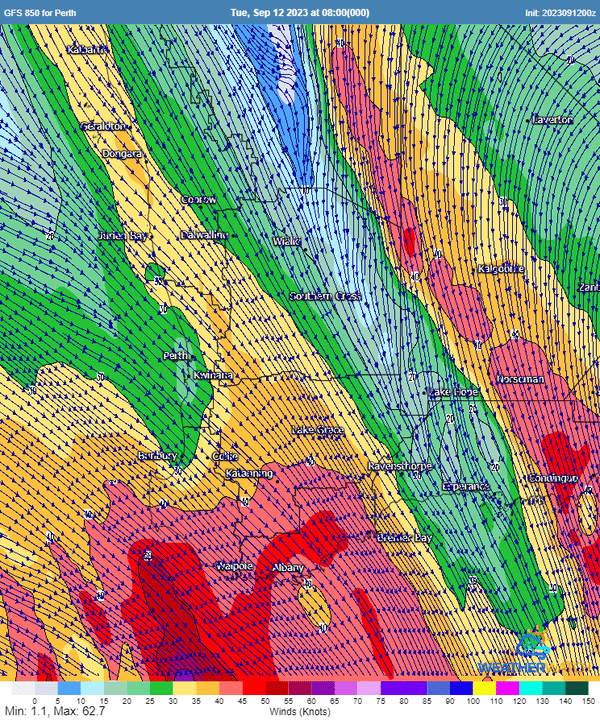
On Wednesday morning, moderate instability will develop across the region. This instability coupled with very strong wind shear associated with a powerful negatively tilted upper trough, and deep moisture will lead to a scattering of severe storms.
Large hail may develop with some thunderstorms, particularly for the southern Goldfields and South East Coastal, along with coastal and adjacent inland parts of The Lower West and South West. Large hail will have the potential to damage numerous cars, properties, and business throughout the southwest, in particular for large metropolitan areas like Perth.
Severe weather will pass over southwest Western Australia on Wednesday (source: Metcentre)
Storms of this nature will also have the potential to produce damaging to locally destructive wind gusts. Very strong winds aloft may be mixed down to the surface within thunderstorms (via momentum transfer) to help create the threat for locally destructive winds in excess of 120km/h.
A few tornadoes may also develop with storm activity across this region, particularly across the coastal fringe and adjacent inland locations. Tornadoes can produce very localised areas of intense rotational winds, capable of producing significant damage and destruction to houses, business, and farmers should locations be impacted. Tornadoes spawning along front of this nature isn’t an unusual occurrence for southwestern WA. Any tornadoes are likely to be isolated and short-lived in nature.
For residents in affected areas, ensure you park your car undercover and away from trees, secure any loose items such as outdoor furniture, umbrellas and trampolines, and be prepared - you may lose services including power and water.
Early Warning Network helps you with accurate and timely information before severe weather hits. Be sure to chat to our team if you want to learn how we can help you.
The blocking pattern, which has been responsible for the essentially unchanging weather across most...
While we saw extreme heat across the country over the weekend, this week will see the return of...
Regions across the Northern Territory and Western Australia are currently facing significant...