Widespread severe weather outbreak to hammer several states
While we saw extreme heat across the country over the weekend, this week will see the return of...
The blocking pattern, which has been responsible for the essentially unchanging weather across most of Australia in recent weeks, is finally set to break down.
This week, many parts of southern and central Australia will experience unsettled weather, with an outside chance of an East Coast Low later into the weekend or early next week.
Today, a low which is currently south of Western Australia will continue to generate showers, thunderstorms, and rain periods across coastal regions, extending inland through the central interior of the state. Damaging wind gusts of up to 100km/h are expected for coastal areas, including Perth, as strong winds wrap around the western periphery of this strengthening low.
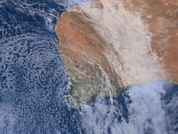
Current satellite image of Western Australia, 29 May 2024.
Overnight Tuesday into Wednesday morning saw moderate rainfall totals develop across the southwest, with widespread falls of 20-40mm. Perth Metro picked up a beautiful 25mm, with widespread shower activity continuing this morning. Meanwhile, Bunbury, south of Perth, has registered 73mm since 9 am Tuesday. This makes this site Bunbury’s wettest May day in history.
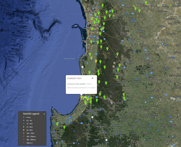
24-hour accumulated rainfall totals to 9am Wednesday 29/05/2024. Image via EWN.
The even better news is that some of this rainfall is pushing into the Wheat Belt region. Most of western and southern Western Australia has been experiencing drought conditions in recent times.
As this low continues to move east, a cold front and trough will extend north, and a significant northwest cloud band will develop through the country's interior, generating cloudy conditions with showers, rain periods, and thunderstorms. This activity will extend from the Kimberley in WA to Adelaide and surrounding regions by Thursday afternoon. Falls of 5-15mm will develop across South Australia, through southern parts of the Northern Territory, and northern parts of Western Australia. Localised heavier falls will be possible.
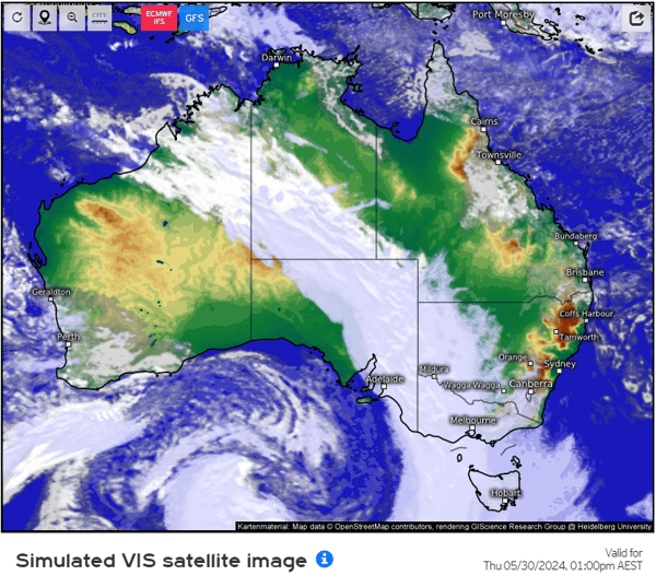
Simulated visible satellite image for Thursday afternoon at 1pm. Image via meteologix.com
South Australia has been bone dry in recent months, with many places likely to see their heaviest rainfall totals in months. Since February 1st, Adelaide has received just 15.4mm, yet averages 126.6mm during the same period.
By Thursday night, an extensive area of cloud and rain will strengthen across the central interior of Australia, extending into central Victoria and Tasmania. Moderate to localised heavy rainfall totals are expected. Parts of eastern and central Victoria and northern Tasmania may see 30-50mm develop, with isolated heavier falls possible. This may lead to flash flooding and localised riverine flooding.
Rainfall won’t be the only factor, with northwesterly winds to strengthen Thursday afternoon as this cold front approaches rapidly. Wind gusts to 110km/h will develop for alpine regions of southern NSW and Victoria, with coastal areas of South Australia likely to see gusts approaching 90km/h. This front will cross Tasmania on Friday morning with strong westerly winds. Gusts of 90-100km/h will likely impact most regions of Tasmania during Friday.
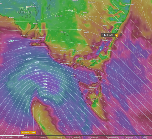
Damaging winds to impact southeastern Australia Thursday night into Friday. Image via Windy.com
Severe weather warnings have begun being issued by the Bureau of Meteorology for heavy rainfall and damaging winds.
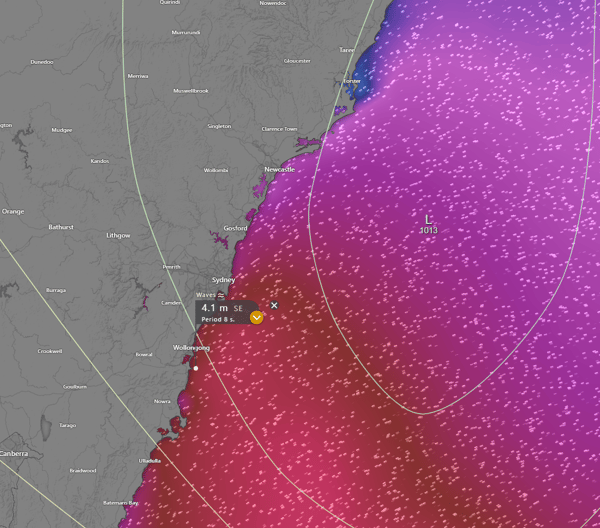
Conditions will rapidly clear into Saturday with a new ridge of high pressure. However, the east coast of NSW will be on high alert. A broad cut-off low will likely shift north across NSW late Sunday with the potential to induce a small East Coast Low off the coast overnight Sunday into Monday. There is still a lot of uncertainty surrounding the prospect of an ECL; however, strong to locally damaging wind gusts may develop from the Hunter region south, including Sydney and surrounding areas, by late Sunday night.
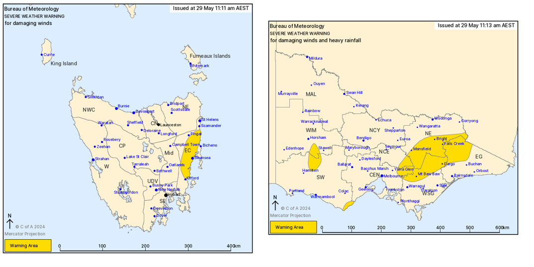
Severe Weather Warnings issued by the Bureau of Meteorology today.
An enhanced area of locally heavy rainfall may also develop across coastal regions of NSW. The main focus for heavy falls will be from Gosford to Narooma, although this will depend on the strength and positions of the potential ECL.
If this low forms where it's expected to, a drier southwesterly flow will be dragged well up into northern New South Wales and southern and central Queensland. This would lead to a period of much cooler days and nights.
Large and powerful waves will also impact the coastal fringe, with coastal erosion expected.
While we saw extreme heat across the country over the weekend, this week will see the return of...
The November 2025 hailstorms across south-east Queensland triggered more than 27,800 insurance...
Severe weather is an ever-present challenge for mining operations, impacting worker safety,...