Australia’s May–July 2025 Weather Outlook
As we transition into the cooler half of the year, the Bureau of Meteorology (BoM) has released its...
Regions across the Northern Territory and Western Australia are currently facing significant weather challenges due to the aftermath of Ex-Tropical Cyclone Lincoln. Authorities have issued severe weather warnings for the southern Gregory, Tanami, and Kimberly districts, forecasting continued heavy rainfall and potential flooding in these areas.
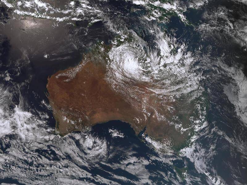
Ex-Cyclone Lincoln, now a tropical low, could redevelop off WA. (Image: Bureau of Meteorology)
The Bureau of Meteorology has indicated that while the Gregory and Tanami districts might see some relief by Tuesday afternoon or evening, the Kimberly district is expected to experience adverse weather conditions into Wednesday. There's also a concern that the weather system could move into the Indian Ocean by mid-week, bringing a chance of regaining its tropical cyclone status.
Rainfall predictions for the Northern Territory suggest daily falls ranging from 10-20mm across central regions, with the Kimberly district bracing for heavier downpours of 50-100mm per day as Ex-Lincoln tracks westward. This season has already seen its share of cyclonic activity, with Lincoln being the third cyclone following Kirrily and Jasper. The impact of these weather events is particularly pronounced in areas still recovering from previous cyclones and flooding, notably in the Victoria River catchment.
The recent spate of extreme weather, coming on the heels of devastating early summer fires, poses additional challenges for the region. Many isolated communities are feeling the strain, with critical infrastructure like the Stuart Highway experiencing closures and damage. This key arterial route has faced issues with water over the road and road damage at various points, notably between Kathleen Street (Tennant Creek) and Mclaren Creek Bridge. Just a month prior, floodwaters inundated the highway, disrupting the delivery of essential supplies to Katherine and the Top End and leading to significant shortages.
The ongoing weather conditions underscore the vulnerability of the region to natural disasters and the importance of preparedness and resilience in mitigating the impact of such events. As communities and authorities work together to navigate these challenges, the focus remains on ensuring the safety and well-being of those affected and on the swift recovery of the impacted areas.
It's in this context that our products have demonstrated their value to our clients in the affected regions. Our solutions have been instrumental in preventing derailments in flooded areas, safeguarding both people and goods that rely on the uninterrupted function of our rail systems.
EWN's Radar-Derived Rainfall system models how much rainfall is occurring over areas where no rainfall gauges exist. It’s not unusual for heavy shower and storm activity to be localised and miss rainfall gauges, particularly in regional Australia, where important rail lines are located. For these lines, heavy rainfall can result in a track-washaway, when the earth under the track is eroded away by flowing water, which can cause a derailment.
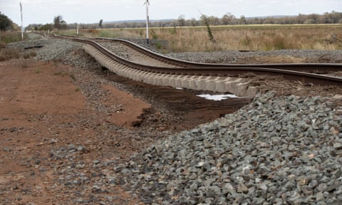
Flood damage on the Parkes-Condobolin railway line in central west NSW. Photograph: Mike Bowers/The Guardian
Supplementing in Radar-Derived rainfall, in addition to also using rainfall gauges, gives rail and logistics operators important data about their routes and network, and ensures you can swiftly implement your operational plan.
An example of RDR's value to businesses was apparent during the storms in NSW & ACT on Boxing Day 2023. During the day, an intense weather event unleashed extremely heavy rainfall between Canberra and Tarago. Between 9am and 9pm, Tarago reported 63mm of rain, while Canberra saw 20mm from the storm's activity.
Notably, there were no rainfall gauges present in the intermediary area, but EWN's Radar Derived Rainfall (RDR) system successfully identified rainfall amounts ranging from 125mm to 175mm within the same duration. As a result of the localised falls, a track wash-away occurred. The RDR alerting system successfully issued an alert for the extreme rainfall - a once in a 500 year event - which prevented a potential derailment for our client.
Without the precise monitoring capabilities of the RDR system, drivers would have remained unaware of the rainfall and track washaway, which would have seen a lack of timely warning for this significant meteorological event, underlining the critical role such systems play in weather prediction and disaster prevention. EWN are successfully using this leading technology with a number of clients across the country, working directly with their teams to create a tailored weather monitoring footprint.
If you would like to talk to our team about how we can help your business prepare for severe weather, please contact us.
As we transition into the cooler half of the year, the Bureau of Meteorology (BoM) has released its...
The Early Warning Network is proud to announce a new Corporate Partnership with Bush Heritage...
Weather forecasting is an essential part of daily life and business operations, affecting...