Dry Lightning Strikes: Aggravating Southern Qld Bushfires
An extreme fire danger is forecast for the Darling Downs region of Queensland on Tuesday and parts...
There will be no dry July for Queensland as record-breaking rainfall swept across the state this week, bringing a sense of relief from the monotonous day-to-day pattern of dry, fine weather.
Mount Isa Mine scored an impressive 83mm in the 24-hrs to 12pm Monday, smashing the previous July site record which dates back 92 years. This wasn’t the only record set with Julia Creek AP, Normanton AP, Mount Isa Aero, Cloncurry AP, Century Mine, The Monument AP, Trepell AP, Winton AP and Birdsville AP all breaking rainfall records for July. However, it was May Downs in the North West of the state that topped the rainfall chart, registering a whopping 101mm in the 24-hrs to 9am Monday morning.
Rainfall totals vs records and July averages. Image via Bureau of Meteorology
Some of these locations saw more than ten times their average July rainfall. This is even more impressive considering the July rainfall outlook that was issued on the 15th of June was for well-below average rainfall. Since this system began several days ago in Western Australian and the Northern Territory, consensus for a significant rain event strengthened, leading to an increased threat for above median rainfall in July for Qld. This second map below was issued on the 29th June 2023.
Party goers heading to the Big Red Bash in Birdsville were caught out by the rainfall, with the road from Windorah to Birdsville closed on Monday due to the rainfall across the region, leaving many stranded.
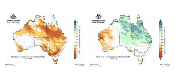
Image supplied by the BOM
SO, WHY DID THIS RAINFALL OCCUR DURING JULY?
An upper trough moving through central Australia has been interacting with moisture-laden air to its east, generating a large northwest cloud band with heavy rain periods and thunderstorm activity across the western half of Queensland. This is the same system that produced areas of rainfall across the Northern Territory over the weekend.
This extensive rain and cloud band then shifted east into central and eastern parts of the state during Monday into Tuesday morning, generating widespread falls of 30-80mm, whilst even producing winter thunderstorms for parts of northern Queensland.
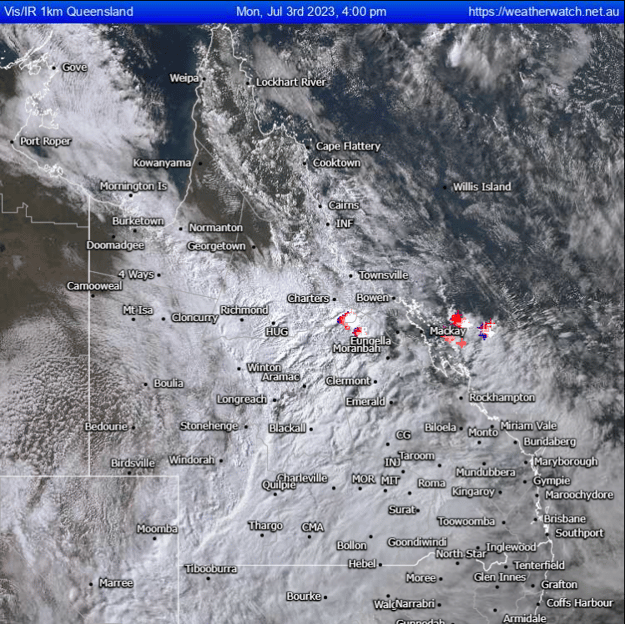 Extensive rain and cloud covering much of Queensland during Monday afternoon. Image via Weatherwatch Metcentre.
Beneath this persistent cloud clover, maximum daytime temperatures have been kept well-below average for July. Canooweal, in the far North West of Queensland only reached a top of 10.7°C on Sunday, making it the coldest July day on record (83 years of records). Whilst this was a one off, Alice Springs saw its coldest 4-day spell since August of 1966.
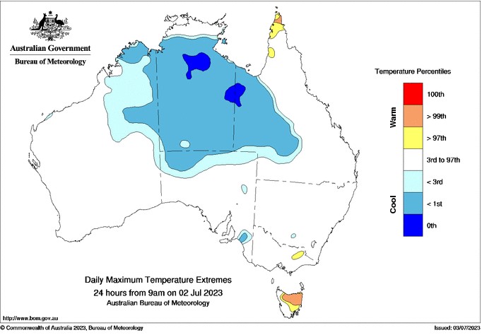
Daily maximum temperature extremes from the Bureau of Meteorology.
If you'd like to talk to our team about any of our severe weather products, get in touch with us now.
An extreme fire danger is forecast for the Darling Downs region of Queensland on Tuesday and parts...
The last few days has been extremely active weather wise acoss southeastern and southwestern...
Victoria and Melbourne specifically are often known for having four seasons in a day, but how...