The Forces Behind Australia's Climate
It has been a noticeably drier year across most of Australia so far compared to the last few years,...
A major rain event is poised to spread across the central interior of Australia next week ahead of a monster upper trough and low with total rain amounts challenging previous June and July records. This is likely to result in flash flooding in parts of the normally arid areas of central Australia, along with the threat for riverine flooding.
Whilst the majority of this rainfall will fall away from populated regions, heavy rainfall leading to flooding is likely to impact severely on winter revellers travelling across central parts of the Northern Territory, Western Australia and northern South Australia. Rainfall of this nature may lead to the closure of major highways, leaving many travellers stranded.
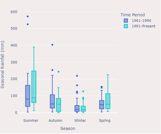
The Early Warning Network’s Climatics database signifies a declining trend in winter rainfall events across this region with a marginally negative trend in seasonal rainfall (p=0.12).
Australia’s most well-known train journey, The Ghan, which operates between Adelaide to Darwin with stops in Alice Springs could also be severely hampered by heavy rainfall. Track washouts and remote outback flooding could cause significant delays under an event like this.
Alice Springs Airport, which sees an average monthly rainfall of just 3.8mm for June and 2.3mm for July may see accumulated rainfall totals of 100-150mm. This event will also have the potential to smash June and July rainfall records for Alice Springs, with the AP's highest daily rainfall total for June at just 70.6mm set all the way back on the 15th 1973, with July’s 76.8mm set on the 1st July 1986.
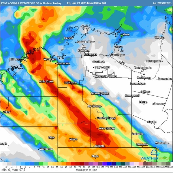 ECMWF 0-240hrs accumulated rainfall for the Northern Territory. Image via Weatherwatch
This rain is then likely to eventually spread further across to some parts of southeastern and eastern Australia though there is still greater uncertainty about what the amounts will be like in those areas.
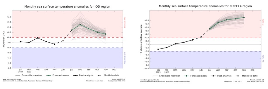 Bureau of Meteorology IOD and ENSO graphs. Valid from 17/06/2023
While heavy rain events can occur during El Ninos and positive Indian Ocean Dipole phases or before they fully develop, they tend to be less common.
This 0-240hr multi view chart shows how much rain the GFS, EC, and ACCESS G models are currently predicting but there are still large differences in where and how much each model is putting the rain in southeastern and eastern Australia. Therefore, we would urge great caution to be used when looking at the rainfall amounts in this chart. However, most of them do agree now on heavy falls for the central interior of the continent.
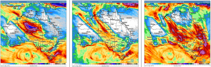 ACCESS G, EC, and GFS 0-240hrs accumulated rainfall Australia Image via Weatherwatch
For detailed weather forecasting and customised alerts which can assist in your route planning, get in touch with us now.
It has been a noticeably drier year across most of Australia so far compared to the last few years,...
While it may be hard to believe after this week's severe storms and flooding that have ravaged much...
Much-needed rain will fall over parts of South Australia on Wednesday and Thursday, with many areas...