Verified Weather Reporting is Helping Insurers Handle Claims with Confidence
After a severe weather event, insurers are faced with two immediate challenges: responding quickly...
An extreme fire danger is forecast for the Darling Downs region of Queensland on Tuesday and parts of northern NSW, as the significant fire crisis continues.
The area has been fighting multiple fires, with about 80 bushfires still burning in Qld on Monday and 75 in NSW. Thunderstorms are predicted for the late afternoon on Tuesday which may seem like a positive, however looking more closely at the forecast it paints a worrying picture.
Hot temperatures will develop during the day, with the mercury expected to hit the high 30s across the region. Westerly winds will also strengthen, with gusts to 60km/h possible. The dry air associated with these westerly winds will also encroach on the area during the day, further enhancing the fire threat for southern Queensland and northern-inland NSW.
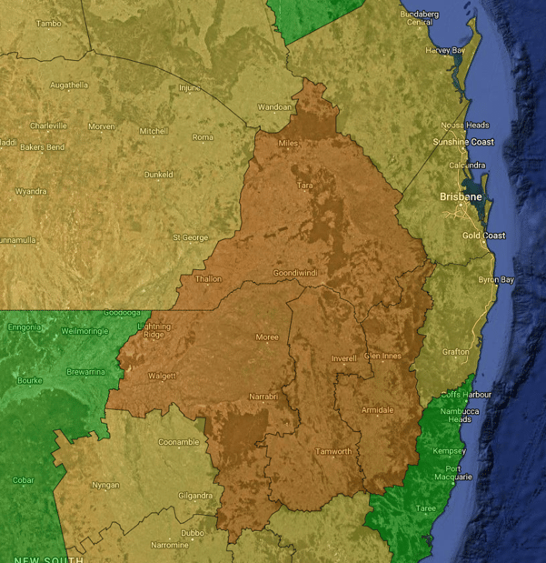
Forecast fire danger for Tuesday 31st October 2023. Image via EWN
Conditions will be too dry for surface-based storm activity to develop during Tuesday afternoon, although a tongue of mid-level moisture will be the catalyst for isolated afternoon storms. These storms will be high-based and produce little to no rainfall, however, high-based storms can be prolific cloud-to-ground lightning producers. Any cloud-to-ground lightning strikes across the Darling Downs - extending into the North West Slopes and Plains and Northern Tablelands of NSW may ignite grass or bushfires during the late afternoon.
Low humidity and cumulonimbus clouds are two of the main drivers of dry lightning, which is expected to increase over summer due to the El Nino in effect. Dry lightning is responsible for igniting over a dozen fires across Queensland in the last week alone.
High-based storms of this nature can also produce damaging wind gusts in the form of dry microbursts.
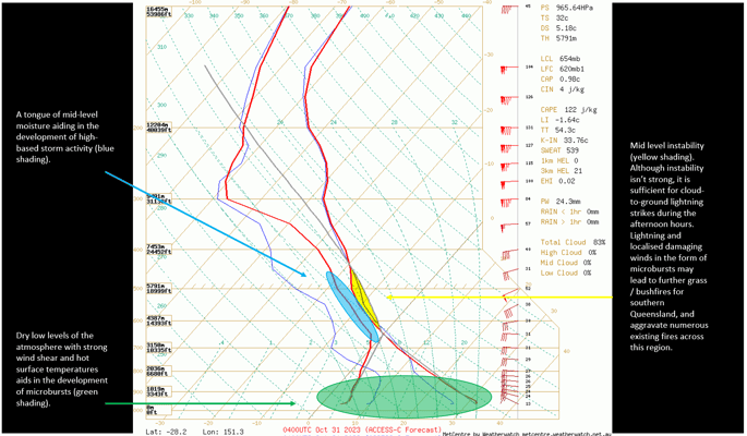
ACCESS C sounding for the southern Darling Downs Tuesday afternoon.
What is a microburst? It is an intense phenomenon that can produce damaging to destructive straight-line winds that span up to 4 kilometres horizontally. This powerful weather phenomenon is driven by evaporative cooling (when precipitation evaporates into the surrounding dry air near the surface), typically weakening as it propagates outwards towards the surface.
Storm activity will move swiftly to the east-northeast during Tuesday afternoon.
For those in southern Queensland and northern-inland NSW, it is critical to be prepared for the weather conditions ahead. Clean yards and gutters, maintain your property and be familiar with your bushfire plan.
Early Warning Network also provides our alerts to a number of councils - check out our support page here to see if you are eligible.
After a severe weather event, insurers are faced with two immediate challenges: responding quickly...
Much-needed rain will fall over parts of South Australia on Wednesday and Thursday, with many areas...
Throughout Western Australia, farmers have been battling against record-breaking drought conditions...