Recent rainfall for central and southeastern coastal Queensland
Showers, isolated thunderstorms and heavy rain areas are expected to contract off the central and...
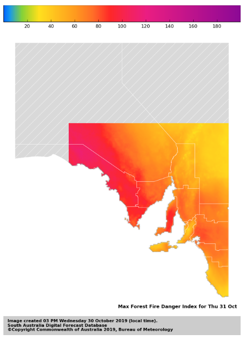
Image 1: Forest Fire Danger Index for South Australia for 31 October, 2019 (Source: Bureau of Meteorology)
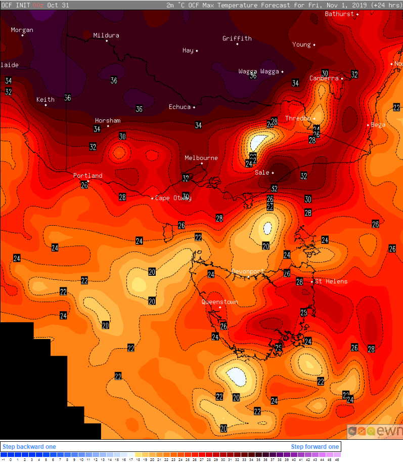
Image 2: OCF Forecast temperatures for 1 November, 2019
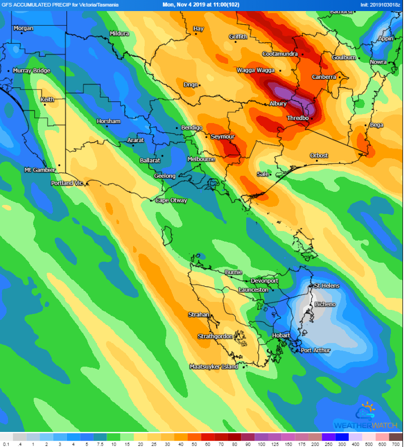
Image 3: Forecast accumulated rainfall to 11am Monday 4 November, 2019
The east coast has made headlines for its bushfires in recent months, however the fire danger is set to rise over the two days across the southern states as potentially record warmth this early in spring affects the region.
A slow-moving low pressure trough ahead of a cold front is currently aligned northwest to southeast across South Australia, Victoria and Tasmania, and is filtering hot northerly winds over the region.
Temperatures are soaring into the mid 30s over the southern capitals, with Adelaide forecast to reach 36 degrees and Melbourne 35 degrees today. Regional areas are also sweltering, with northern Victoria reaching into the mid 30s and northern SA the low 40s. In Tasmania, the mercury is reaching into the mid 20s to early 30s.
Tomorrow, similar temperatures are likely, though it will begin to cool down in SA as a cooler change spreads from the west. With 32 degrees forecast tomorrow, it could be Hobart's hottest pair of days this early in spring tomorrow providing today reaches the forecast top of 30 degrees.
The heat is combining with dry and gusty northerly winds, which is causing the most widespread elevated fire danger of the season so far. Very high to Severe Fire Danger is affecting much of SA today, whilst very high fire danger is forecast for large parts of VIC and TAS.
Increasing heat and winds tomorrow will increase fire danger further over TAS, VIC and into western NSW as well, with some areas possibly seeing severe fire danger.
Unlike NSW that continues to see extended drought and fires breaking out, there will be significant relief from the heat almost immediately as the trough and front bring rain areas, thunderstorms and cool change later on Friday and into the weekend. Widespread falls of 5-15mm are likely, with parts of northern Victoria and inland NSW seeing falls of 20-to-40mm.
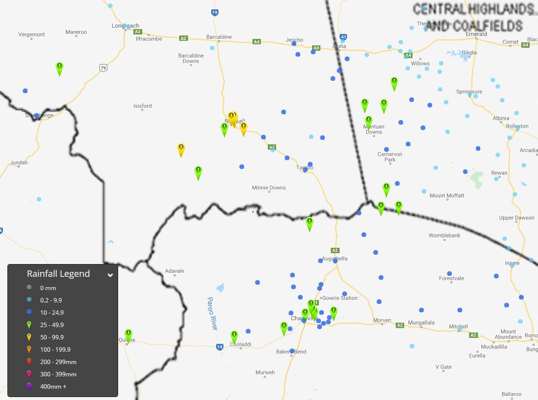
Image 1: Rainfall totals from 9am 29/10/2019-2:40pm 30/10/2019. EWN rainfall map.
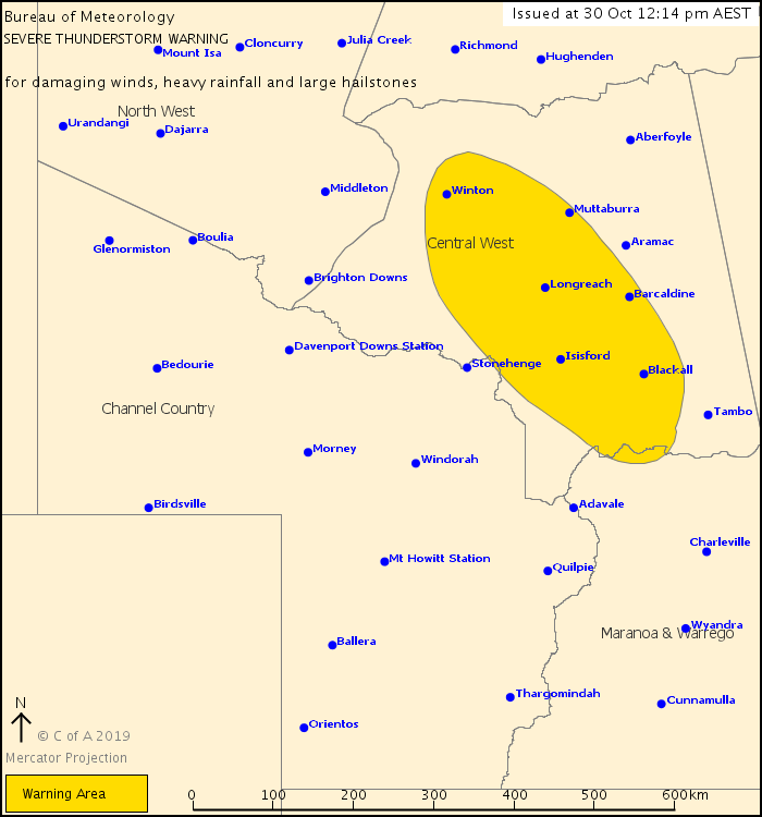
Image 2: Severe thunderstorm threat map, Bureau of Meteorology
After months of dry, hot and dusty conditions, some relief in the form of patchy rain and storms has developed across parched regions of central inland Queensland.
Whilst not drought breaking, the best rainfall in months has fallen, providing that ray of hope that better times might be around the corner.
Parts of the Central West and Central Highlands received the heaviest falls in the 24hrs to 9am this morning, with the Upper Claude River picking up an impressive 50mm, Sunbury 47mm, Fairview 43mm and Mt Harden 40mm.
Further south, in the Warrego and Maranoa, Cooks Tank received 27mm, Warilda 29mm, Charleville 13mm and Augathella 17mm.
Further showers, storms and rain periods have developed throughout Wednesday with impressive follow-up totals this morning with Blackall picking up a further 50mm and Duneira 37mm.
Over the next 24-48hrs further falls are expected, with widespread totals of 20-30mm likely and isolated falls up to 80mm, particularly with storm activity. A severe thunderstorm warning is current across the region for damaging winds, heavy rainfall that may lead to flash flooding and large hail stones.
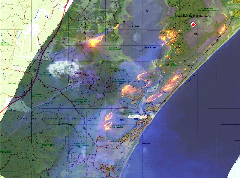
Image 1: Fireground burn map - NSW RFS Lake Innes and Lake Cathie bushfire - October 29th, 2019.
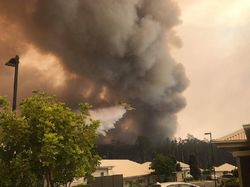
Image 2: Waterbombing Aircraft - Viewed from Ocean View Resort, Lake Innes and Lake Cathie bushfires - Photo submission via Carolyn Sanderson.
As of 3:00pm, 70 bush and grass fires are burning across the state of New South Wales, with 41 of these still yet to be contained. Hot and windy conditions are expected to escalate the fire potential later this week.
The main focus of emergency bushfire activity is currently situated south of Port Macquarie, with bushfire burning in the vicinity of of Lake Innes and Lake Cathie. The bushfire breached containment lines earlier today and is swiftly moving in a southerly direction. Strong northeasterly winds have been directing smoke and embers well ahead of the main fire front, creating numerous new spot fires. Reports of these spot fires have been reported to the west of Lake Cathie village, and in the area of Lake Innes Nature Reserve.
Firefighters and water-bombing aircraft have been working throughout the afternoon to slow the spread of the fire and protect properties in the area. People situated within the area of Lake Cathie, Long Point or Bonny Hills are advised to watch for burning embers.
Another significant bushfire in the town of Darawank, NSW last weekend has resulted in fire damage with at least one home confirmed to be destroyed. The out of control bushfire was heading in a northeasterly direction for the town of Hallidays Point, with multiple other bushfires burning in the vicinity of The Lakes Way. Forster and Tuncurry, NSW itself were also under direct ember attack as strong winds carried burning embers aloft ahead of the main fire front. The situation across the fireground has eased over the past three days with the fireground reported to be 2693ha in size. This bushfire current sits as an Advice and is currently being controlled by the NSW RFS.
With no reprieve in the short sight, very high fire dangers are set to continue through the rest of this week and into this coming weekend, especially for central and northern inland regions of the state with hot daytime temperatures and windy conditions. Scattered showers and isolated thunderstorms are expected about the northern inland ranges of NSW tomorrow, and also about the North West Slopes and Plains into Thursday due to the approach of an upper level trough.
Dry lightning from elevated thunderstorms may provide an additional bushfire hazard and/or ignite additional bushfires with dry and tinder conditions. As always, please keep vigilant and up to date with the latest severe weather alerts via the Early Warning Network.
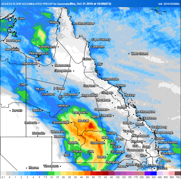
Image 1: 72 hour rainfall forecast from the ACCESSR Model to 10am EST Thursday 31 October, 2019 (Source: Weatherwatch Metcentre)
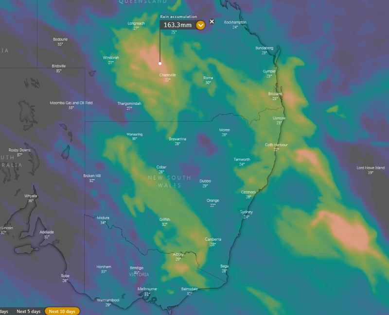
Image 2: Accumulated precipitation across the next 10 days from the ECMWF Model (Source: Windy)
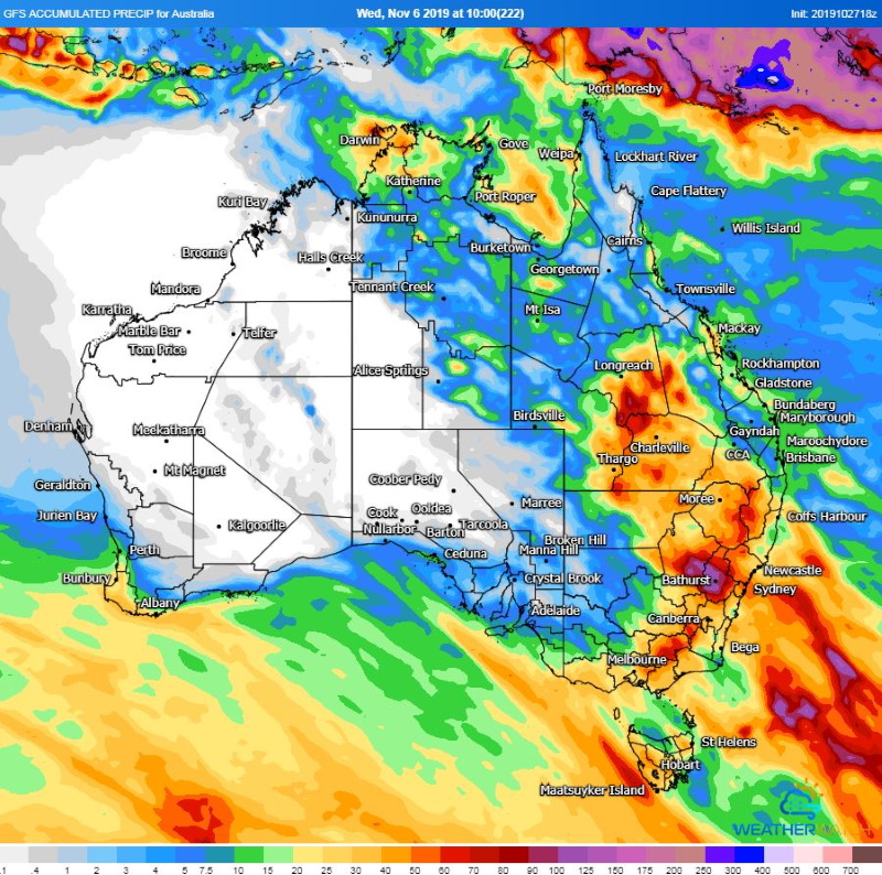
Image 3: Accumulated precipitation from the GFS Model until 10am EST Wednesday 6 November, 2019 (Source: Weatherwatch Metcentre)
Moderate to heavy rain is set to bring the best falls in months over inland Queensland over the next few days, with this rain possibly reaching Victoria, Tasmania and New South Wales later this week or by the weekend.
After more bushfire conditions ravaged eastern Australia over the weekend, the weather patterns are set to shift as moisture increases over the east of the nation.
Areas of rain and embedded thunderstorms are spreading acorss far western QLD today along a trough, however falls are only expected to be patchy with many areas likely to miss out.
However as the system moves a little further east, it will collect more moisture with more widespread and heavy totals likely tomorrow. Those over the Central West, Maranoa & Warrego and eastern Channel Country are likely to fare best with some areas receiving 24 hours totals of 20-30mm, with isolated falls of up to 100mm possible.
On Wednesday, the rain areas are likely to become less widespread with the extra heating allowing thunderstorms to become more prominent. This will mean falls will become patchier due to the convective nature of thunderstorms, however further daily totals of 15-30mm are possible, with isolated falls of 50-100mm under heavier thunderstorms.
For many areas, this will likely be their best rain since autumn, however there is the risk that those under the heavier cells could see their best rain in years.
However, there is now good alignment with models that this moisture is likely to link up with a trough moving across the country from Friday and into the weekend to produce moderate to heavy falls across VIC, TAS and NSW, before possibly shifting into QLD again early next week.
Whilst it is far too early to accurately estimate rainfall totals for this part of the system, any rain will likely help the bushfire situation with around 90 bush and grass fires currently burning across NSW.
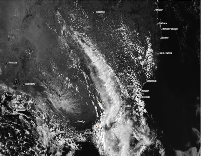
Image 1: Satellite Image for southeastern Australia on Friday 25 October, 2019
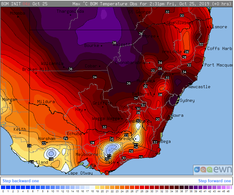
Image 2: Maximum temperatures observed for southeastern Australia Friday 25 October, 2019
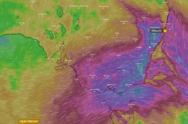
Image 3: Wind gust forecasts for NSW and VIC on Saturday 26 October, 2019 (Source: Windy)
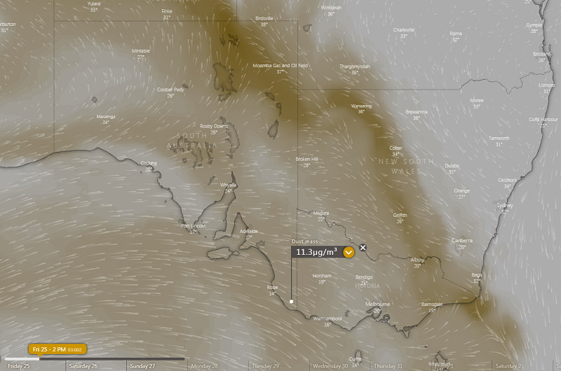
Image 4: Dust mass index for Friday 25 October, 2019 (Source: Windy)
The highest temperatures since March, dry thunderstorms, fire weather, wind gusts in excess of 100km/h and dust storms have hit parts of southeastern Australia in the last 24 hours as a vigorous cold front sweeps across the region.
Temperatures skyrocketed to the highest they've been since March across parts of South Australia, Victoria and southern New South Wales on Thursday, reaching the mid-to-high thirties, with some places pushing into the low 40s.
It was a stifling night for many regions as well as the gusty northerly winds kept the mercury well up. In Melbourne, it was hovering around 27 degrees for much of the night before a cooler change around 7:30am brought it down to the mid-to-high teens. For some others areas that didn't receive the change however, October records were broken, including Kyabram which only dropped to 21 degrees (50 years of records), and Lake Eildon which only fell to 20.8 degrees (47 years of records).
The high temperatures aided in the formation of thunderstorms, which unfortunately contained little if any rainfall due to low moisture. However, the thunderstorms brought with them damaging wind gusts to several places, including a 106km/h gust at Renmark, 90km/h gust at Coober Pedy and 95km/h gust at Renmark. This combination of high temperatures and low moisture can lead to the formation of high based thunderstorms which are predisposed to dry microbursts.
Northerly winds ahead of the change, and the change itself also contained strong and gusty winds, with gusts to 70-80km/h helping fuel dangerous bushfire conditions, with a number of fires breaking out. These winds also whipped up dust, with dust riding the leading edge of the front.
Today, and into tomorrow, the system will continue to bring hot, stormy and windy conditions, mainly across NSW and also QLD. Temperatures have reached into the mid-to-high 30s across large parts of NSW today, with gusty northwesterly winds ahead of the change increasing fire danger and a line of dry thunderstorms forming along the pre-frontal trough.
Tomorrow, winds are expected to become even stronger over VIC and NSW, and combine with high temperatures to lead to Severe Fire Danger over parts of southern QLD and central and northern NSW. Meanwhile, the south of the country will be experiencing temperatures in the mid-to-high teens, with snow about the peaks.
One of the reasons behind the strong cold front is a negative Southern Annular Mode, which is the lowest it's been since 2016. This is a result of the Sudden Stratospheric Warming event that occurred in late August.
As a result, we can expect enhanced frontal activity over southeastern Australia over the next several weeks. This is good news for Tasmania, Victoria and parts of South Australia which will see increased rainfall in this scenario, however further north this generally results in dry and windy conditions conducive to bushfires.
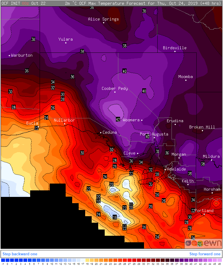
Image 1: OCF Forecast temperatures for Thursday 24 October, 2019 for SA
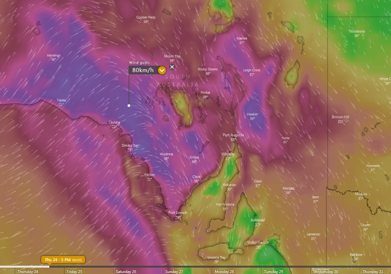
Image 2: Wind gust forecasts for SA for Thursday 24 October, 2019 (Source: Windy)
The next two days are set to see the mercury rise across much of South Australia, with Thursday likely to see the hottest temperatures, coupled with fire weather and thunderstorms as a cold front sweeps across the state.
A low pressure trough coming in from the west is causing warmer northerly winds to push across the state. While today was warm, tomorrow is set to be even warmer as the hottest part of the airmass begins to enter South Australia.
Adelaide will push into the mid 30s for the first day this spring, whilst those of the far west and north will see temperatures pushing into the mid-to-high 30s. Thankfully, winds are expected to be light tomorrow, so fire weather is not expected to be bad, although the airmass across the state will be dry.
On Thursday, temperatures will soar as northerly winds strengthen and become gusty, with many parts of the state reaching the mid-to-high 30s, and some locations even reaching into the low 40s.
Unfortunately, dry northwesterly winds are expected to be fresh to strong and gusty at times, enhancing the risk of bushfires. A squally southwesterly change is also expected to accompany the front, which will make it difficult for firefighters as they potentially deal with a rapid change in the directions of fires..
Thunderstorms are also expected with the change, mainly over western and northern areas. These thunderstorms are expected to contain little if any rain, further enhancing the risk of lightning starting bushfires. The hot conditions coupled with the dry air will also increase the chance of dry microbursts with any thunderstorms.
The cool change will have moved through much of SA by Friday, bringing cooler conditions, particularly across the south. Adelaide is expected to only reach the high teens from Friday and throughout the weekend in the wake of the change, before warming up again next week.
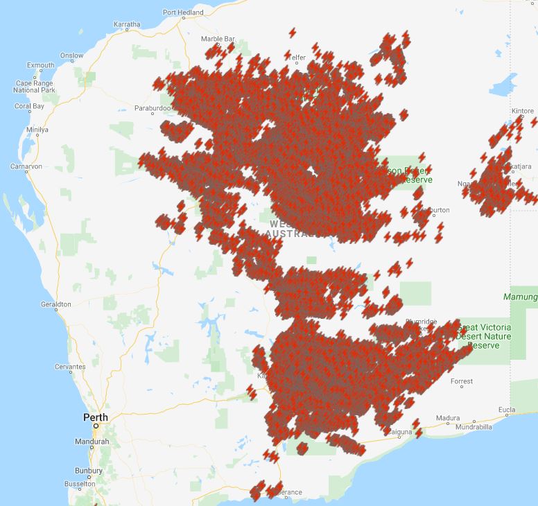
Image 1: Past 24hr lightning from myfirewatch.landgate.wa.gov.au
Image 2: EWN satellite and lightning tracker yesterday afternoon.
Thunderstorm activity fired up across central parts of WA during Sunday afternoon, thanks a low pressure trough situated across the region.
Widespread activity stretched from the Northern Interior down to the South East Coastal District during the evening hours.
A severe thunderstorm warning was issued for parts of the Goldfields for damaging winds gusts in the form of microbursts with high based, dry thunderstorms. Leonora recorded a gust to 76km/h at 1pm, with Zanthus picking up a handy 15mm in 30 minutes.
This afternoon, more widespread high based storm activity is expected, with the potential for a few of these storms to once again become severe with damaging winds in the form of microbursts.
Image 1: Lightning strikes out in front of the storm front near Springwood, QLD on Thursday 17 October, 2019 (Source; Andy Barber)
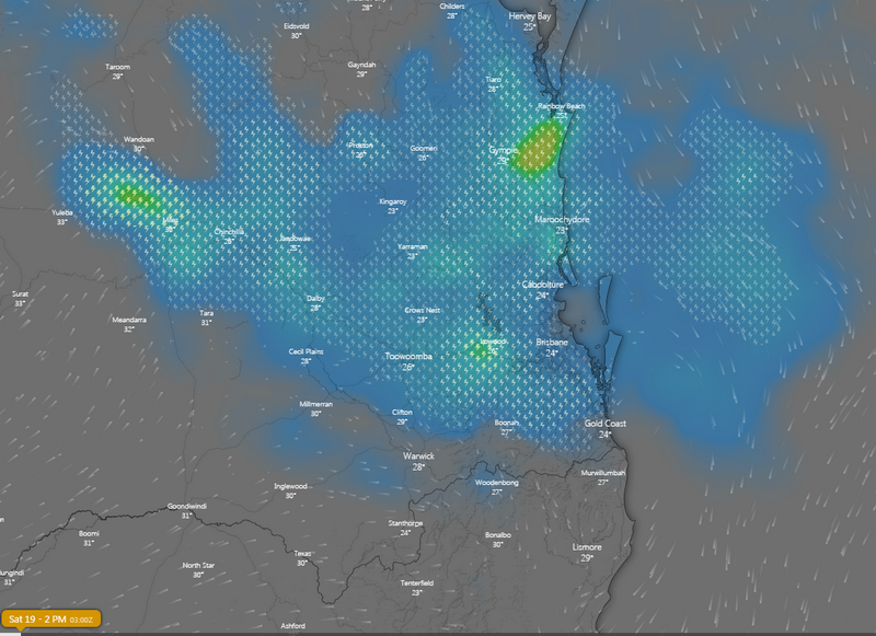
Image 2: Lightning forecast for Saturday 19 October afternoon over southeast QLD (Source: Windy)
A line of severe thunderstorms swept across southeast Queensland yesterday, leaving thousands without power, bringing small hail and producing a spectacular lightning display.
The line, which was part of a complex that stretched from Grafton in northeast NSW up to Emerald in southeast QLD, intensified over parts of the southeast as it hit the coastal moisture. Those in in Logan City Council, Ipswich City Council, Lockyer Valley and Scenic Rim copped it the hardest, with more than 20,000 homes left without power due to strong winds and lightning. Some places also reported hail as large as 10 cent piece in diameter.
Today, these thunderstorms have contracted into central east QLD, including the Central Highlands & Coalfields and inland parts of the Wide Bay & Burnett and Capricornia, where thunderstorms bring the risk of large hail and damaging winds this afternoon and evening.
However, tomorrow thunderstorms are again expected to fire up over the state's southeast, with the most widespread thunderstorm activity likely on the Darling Downs & Granite Belt, Southeast coast and Wide Bay & Burnett. Strong wind shear aloft makes severe thunderstorms likely, with the risk of large hail and strong winds. Those over the northern southeast coast, eastern Darling Downs and Wide Bay & Burnett also have the chance of very heavy rainfall leading to flash flooding, with isolated totals in excess of 30-to-40mm possible.
Thunderstorm activity will clear the region on Sunday due to a strong and gusty southeast change.
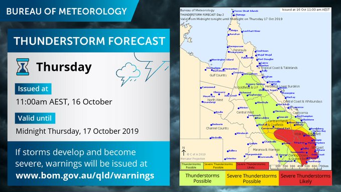
Image 1: Bureau of Meteorology thunderstorm forecast. Thursday 16th October. Image via Twitter.
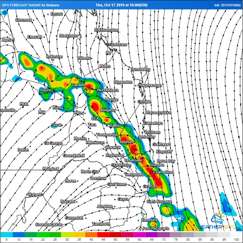
Image 2: GFS forecast radar 4pm. Image, WeatherWatch MetCentre.
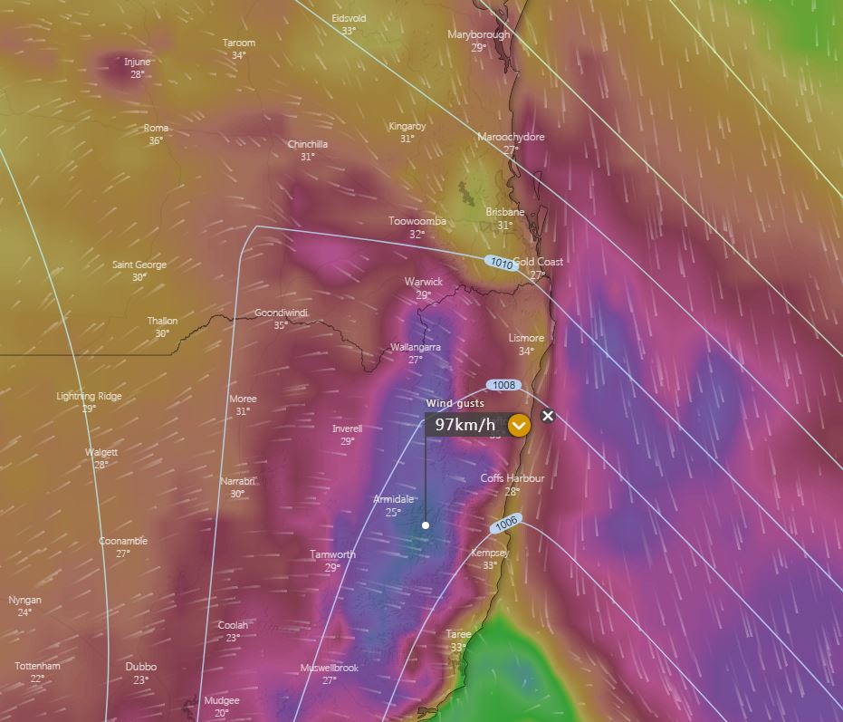
Image 3: EC wind gusts Thursday afternoon. Windy.com
After a slow start to storm season, the first significant thunderstorms of the season are set to develop for parts of SE QLD and NE NSW Thursday during afternoon.
An upper trough and surface trough will combine with increasing moisture to produce a moderately unstable environment across eastern NSW and QLD.
This is expected to lead to a scattering of thunderstorms developing across the Darling Downs whilst rapidly moving east during the early afternoon hours.
Strong, but linear wind shear through the atmosphere is expected to help in the development of clusters or lines of thunderstorms, with the potential for a large squall line to develop across southern QLD, extending into northern NSW.
If this scenario unfolds, a few storms are likely to become severe, with damaging winds being the primary threat. Should storm activity interact with the sea breeze front across the coastal plain, large hail may become a threat, however this is considered low at this stage.
In the wake of this system, strong to locally damaging west to northwesterly winds to 90km/h may develop across parts of the Northern Tablelands of NSW during Thursday afternoon. This will lead to an increase in fire danger across this region which has already been decimated by recent fires.
Further dust storms will develop across inland parts of the state, reaching the east coast late Thursday evening before clearing Friday.
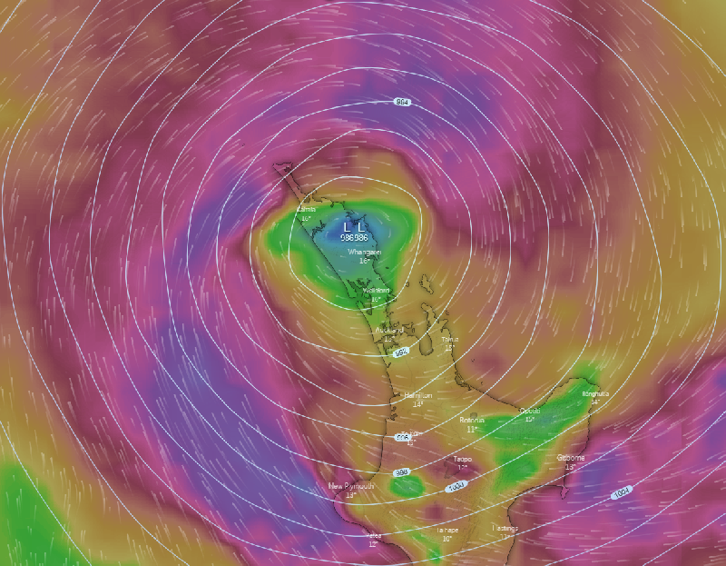
Image 1: Winds and pressure bars of intense low pressure system situated over Northland at 8:00am via Windyty - October 15th, 2019
Wild winds and very heavy rainfall have lashed the North Island of New Zealand overnight with the Coromandel area receiving the bulk of the rainfall, receiving 130mm of rainfall in a 12 hour period between 5:00pm yesterday and 5:00am this morning.
Hundreds of residents in Auckland were without power with wind gusts up to 100km/h, especially to the north of the city at Whangaparaoa. Power is also out in parts of the Coromandel area with major flooding closing some sections of State Highway 25, however this road has now reopened for thoroughfare.
Residents situated in the Bay of Plenty area awoke to scenes of trees down and uprooted, garden sheds blown over with some damages to roofs and homes evident from the damaging winds overnight. Western parts of the Bay of Plenty received winds with peak gusts to 110km/h during the early morning, with the strongest gust of 160km/h recorded at White Island in the eastern Bay of Plenty.
As of 8:00am this morning, the center of the low pressure system responsible for the heavy rain and damaging winds was situated directly over Northland, bringing east to northeast winds into Auckland. Gales are still expected around parts of the Great Barrier Island before the low clears over the East Cape tomorrow with residual winds and rain areas. Conditions are expected to vastly improve into Thursday at this stage.
Remember to keep up-to-date with all warnings and severe weather alerts via The Early Warning Network (Email, SMS, Facebook and Twitter). #ewnalerts #earlywarningnetwork
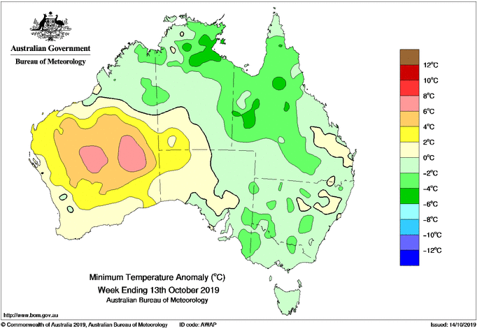
Image 1: Minimum temperature anomolies for the week ending 13 October, 2019
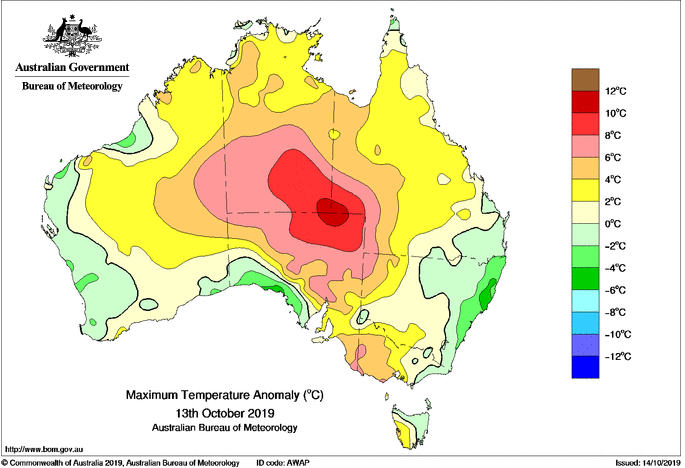
Image 2: Maximum temperature anomoly for 13 October, 2019
Sizzling heat and catastrophic fire danger is affecting Australia's interior as the mercury soars above 40 degrees, however those in the tropics are shivering through uncharacteristically chilly nights.
Unseasonably hot conditions are affecting inland Australia, with temperatures soaring up to 10 degrees above average. Alice Springs is forecast to reach 39 degrees today and 40 degrees tomorrow (after similar temperatures the last two days), putting the inland city on track to register its hottest October on record.
A little further west, over the WA interior and far southwest NT, strong winds are combining with this heat to produce catastrophic fire conditions, although thankfully vegetation in this part of the world is sparse.
However, over the northern tropics conditions have been quite different, particularly at night. Daytime temperatures have been mostly average to above average, however the night times are tracking two-to-four degrees below average for the month so far, with some short term sites possibly heading towards their coolest October nights on record.
On Sunday morning, Groote Eylandt dipped to just 11.8 degrees, 9 degrees below the average of 20.9 degrees, whilst on Saturday morning Daly Waters dipped to 11.5 degrees, almost 10 degrees below average.
Those over north Queensland who saw some of their coldest September nights on record continue to feel the chill this month too, with many sites running two-to-three degrees below average for October.
The reason for the cold nights further north has been the below average humidity, with widespread drought conditions gripping the nation, and strong cold fronts pushing this dry air well into the tropics.
Unfortunately, these are poor signs for the wet season ahead, with dry conditions and cool nights lasting this late in the year generally a sign that the monsoon will be delayed or weak, which is bad news for a nation in desperate need for rain.

Image 1: Be prepared emergency kit. For further information, www.stormwise.com.au
Storm season is now upon us and every year many people leave it to the last minute to get their house ready. So, here are a few tips on how to prepare.
Have an emergency plan for yourself and any pets, emergency contact numbers, evacuations points, areas of the house to take shelter (underground, an inner room or bathroom is best).
Prepare an emergency kit for the worst-case scenario. Emergency kits should contain the following: Three (3) days of non-perishable food, portable radio, spare batteries for a torch, radio and mobile phone, essential medication, phone charger, gloves, fresh water for three (3) days, toiletries, water proof bags, first aid kid and any important documents.
When preparing your house, clean out gutters for any debris, tie down loose objects that may become flying missiles during severe weather events eg: trampolines, garden furniture and toys, cut down large or over hanging trees and branches that may be able to come down onto your roof during a severe weather event, disconnect electrical appliances, store cars under cover where possible (not under trees), pay attention and heed all warnings from the Bureau of Meteorology and take shelter in the strongest parts of the house, usually a bathroom or interior room and stay away from windows.
These may seem like extreme measures, however on the day that severe weather does strike, they may just be life saving for you and your family.
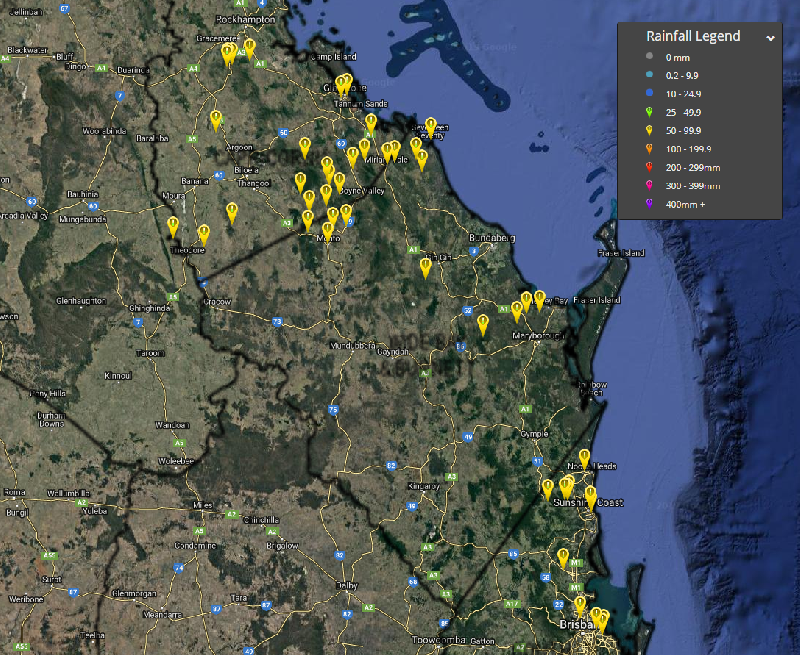
Image 1: Capricornia and Wide Bay and Burnett Rainfall Observations >50mm. 24 hours to 9:00am - October 12th, 2019
Showers, isolated thunderstorms and heavy rain areas are expected to contract off the central and southeastern coastal districts of QLD during later today, with conditions easing and clearing into Sunday as an upper level trough exits the region.
A few locations, especially around the Capricornia and Wide Bay and Burnett coastal and adjacent inland districts received greater than 50mm of cumulative rainfall over the past 24 hours.
Capricornia and Wide Bay and Burnett: >50mm of rainfall (24 hours to 9am today):
Southeast Queensland: >50mm of rainfall (24 hours to 9am today):
Remember to keep up-to-date with all warnings and severe weather alerts via The Early Warning Network (Email, SMS, Facebook and Twitter). #ewnalerts #earlywarningnetwork
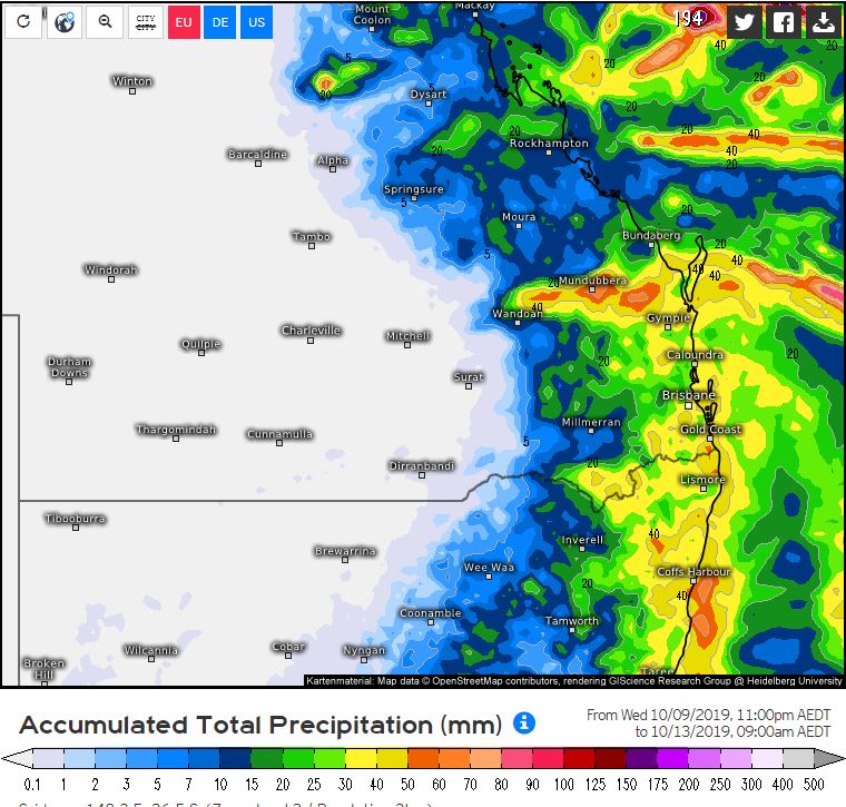
Image 1: EC accumulation precipitation, Friday 9am to Sunday 9am. Weather.US
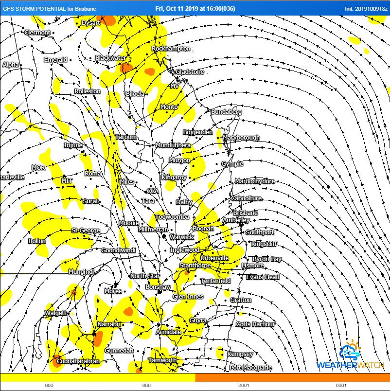
Image 2: GFS storm potential for Friday afternoon. WeatherWatch MetCentre
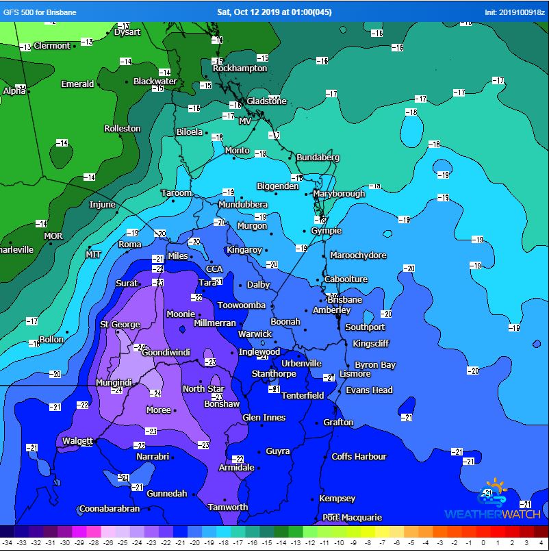
Image 3: 500mb temperatures showcasing very cold air aloft moving across NE NSW and southern QLD. WeatherWatch MetCentre
After and extremely dry winter, and horrific start to the fire season, some much needed and welcome rainfall is finally on its way for eastern QLD and NSW.
A broad upper trough will combine with moisture laden east to northeasterly winds to generated scattered showers, rain periods and isolated thunderstorms during Friday, peaking during Saturday morning before clearing Sunday morning.
Falls of 20-40mm are expected, with isolated heavier falls of 50-100m possible, particularly with thunderstorm activity. This will be a welcome relief for fire ravaged regions, with the potential for a couple of ongoing fires to be extinguished from this event.
Wind shear profiles will be favourable for severe thunderstorms across central and southern inland QLD on Friday afternoon, however, heavy cloud cover may mitigate the severe potential across this region. Should strong heating occur, severe storm potential will increase with moderate to large hail and damaging winds possible.
Late into the weekend, a low pressure system may develop well off the QLD coast and move in a south-easterly direction, generating south-easterly winds with showers for coastal QLD and NSW. Further showers and storms may redevelop around mid-week, providing the perfect follow up rainfall.
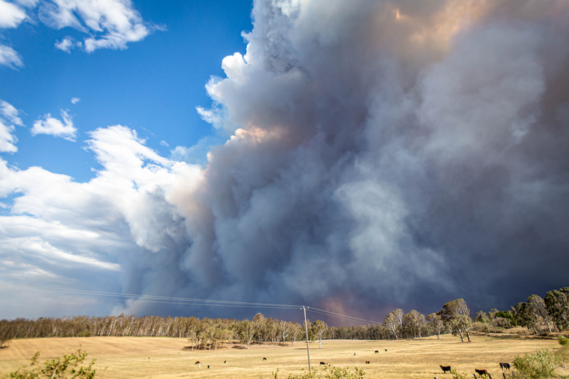
Image 1: EWN's Justin Noonan on location. Rappville, NSW.
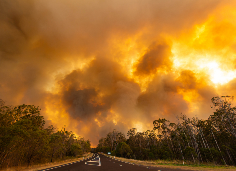
Image 2: EWN's Justin Noonan on location. Rappville, NSW.
An extremely hot, dry airmass that moved over eastern Australia, combined with gale force westerly winds during Tuesday afternoon to spawn several emergency warned fires across northern NSW and southern QLD.
During Tuesday afternoon, emergency warned fires raged for parts of Drake, Tenterfield, Jackadgery and Rappville in northern NSW, whilst fires at Laidley and Lefthand Branch also reached emergency status during the afternoon hours.
Temperatures soared into the high 30's and low 40's with humidity dropping to below 10% and winds gusting to 60-70km/h, fuelling the dangerous fires.
Sadly, one home was lost in Laidley, however it was Rappville, just south-west of Casino in northern NSW that was hardest hit. Up to 30 homes had been lost in the small community, including the towns mill which provides employment across the region.
The fires were so ferocious, farmers literally had to cut fences to let livestock run onto the highway (Summerland way) before the flames engulfed the entire region.
Many residents chose to flee their homes, packing up personal belongings and family pets before evacuating. Whilst conditions eased slightly overnight, gusty winds are expected to continue across the region during Wednesday, before easing further in Thursday.
Relief might be on the way, with the potential for showers, storms and patchy rain to develop during Friday and into Saturday. It is still too early to lock significant falls in, however totals of 10-20mm could be expected, particularly with any storm activity.
Image 1: OCF forecast temperatures for Monday and Tuesday, WeatherWatch Metcentre
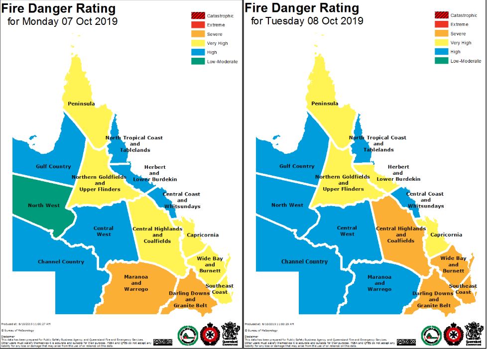
Image 2: QFES fire danger ratings, Monday and Tuesday
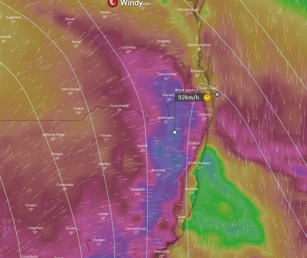
Image 3: Wind gusts Tuesday afternoon. Windy.com
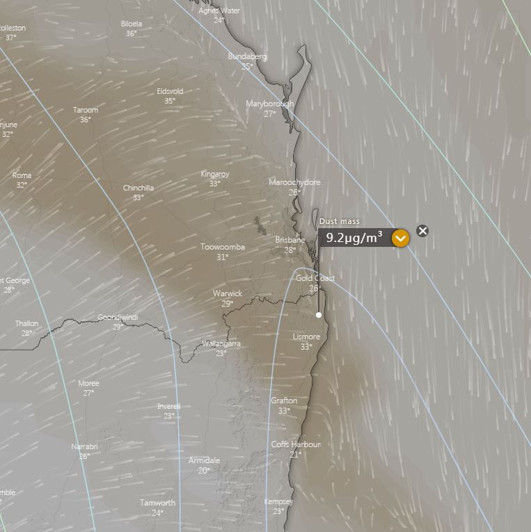
Image 4: Potential dust mass, Tuesday afternoon. Windy.com
Image 5: Thunderstorm and precipitation forecast for Friday afternoon
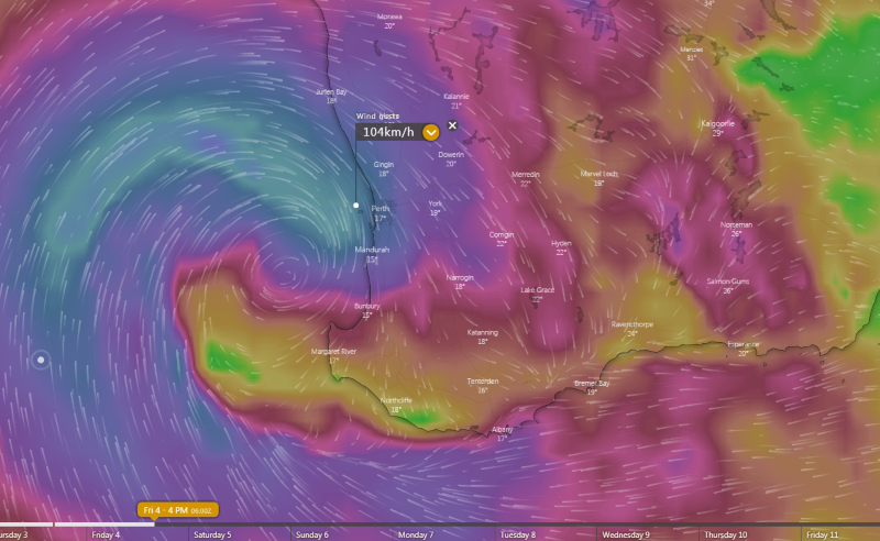
Image 6: Wind gust forecast for Friday afternoon
A ridge over QLD will generate northwesterly winds ahead of an approaching cold front and associated low pressure trough. This will generate a very hot airmass over eastern Australia during Monday and Tuesday.
This very hot airmass will send maximum temperatures soaring into the late 30's and potentially early 40's for numerous locations across southern inland QLD and northern NSW during Monday, before contracting to coastal areas into Tuesday. Cool southwesterly winds will move across inland locations during Tuesday, dropping maximum temperatures up to 10 degrees.
Boonah, in SE QLD is expecting a maximum temperature of 41C Monday, and 40C Tuesday, Gatton 41C and 40C, Warwick 38C and 35C, Dirranbandi 40C and 41C, Brisbane 34C and 36C. In NSW, Warialda 39C and 33C, Narrabri 39C and 29C, Moree 39C and 31.
This extreme heat and gusty winds will lead to severe fire danger for parts of QLD and NSW on Monday as temperatures skyrocket. However, it is Tuesday that shapes up as a potentially volatile fire day as strong to potentially damaging westerly winds move across northern NSW and far southern QLD, with the potential for dry lightning to develop.
Gusts of 60-80km/h are expected, with isolated gusts to 90km/h possible during Tuesday afternoon, particularly for parts of the Northern Tablelands in NSW.
Dusts storms are likely to develop once again across inland regions, with the potential to reach the east coast late Tuesday evening. This may cause further issues for asthma sufferers and people with severe hay fever.
A high will cause conditions to ease on Saturday, with only light showers lingering along the coastal fringe by Sunday and temperatures a couple of degrees below average.
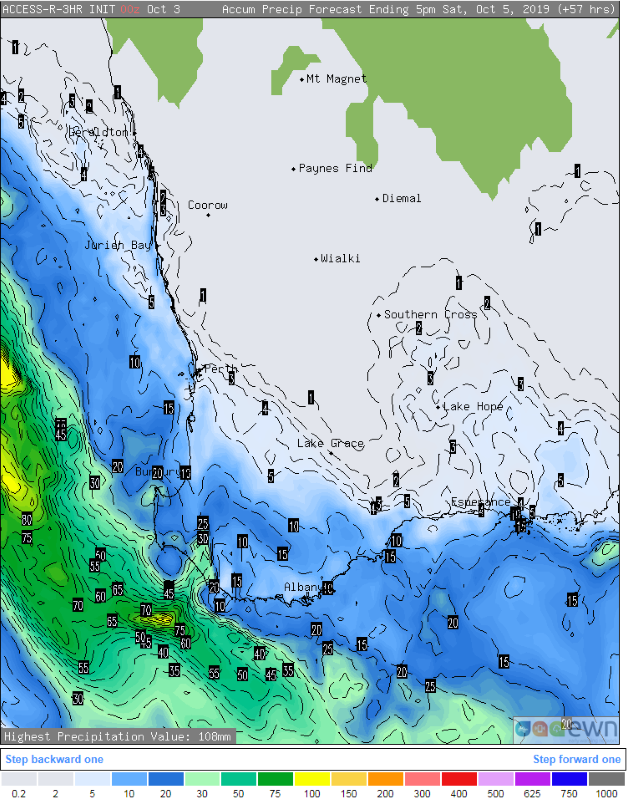
Image 1: Accumulated precipitation for southwest WA over the next two days
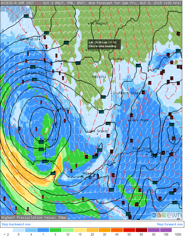
Image 2: Forecast Mean Sea level pressure and rain for 2pm Friday 4th October
Image 3: Thunderstorm and precipitation forecast for Friday afternoon
Image 4: Wind gust forecast for Friday afternoon
A cut-off low is expected to bring damaging winds across southwest WA from tomorrow morning, with showers and the risk of thunderstorms also expected to accompany the system.
The system is currently lying over the Indian Ocean and is slowly moving towards the coast, and is expected to rapidly deepen this evening and into the early hours of tomorrow morning.
The far southwest corner is expected to see some patchy rain and very isolated thunderstorms tonight and into tomorrow morning, with some isolated moderate falls expected along the coastal fringe of the South West district. Lighter falls will spread further east, however most areas will see less than 5mm.
However, the main feature over more populated areas will be the winds, which will increase on Friday morning and peak during the afternoon and evening.
Areas between Bunbury and Geraldton and east to Koorda will be the hardest hit with widespread wind gusts in excess of 70-80km/h, although those in exposed coastal and elevated areas (such as Rottnest Island) will see even stronger gusts, reaching in excess of 90-100km/h.
The winds will be strong and sustained enough to bring a significant risk of damage over southwest WA, with trees and powerlines likely to fall and power outages likely in some areas.
Further south in the the South West, Great Southern, South Coastal and South East Coastal districts, winds are not expected to be as strong, however thunderstorms will be much more prominent. These thunderstorms may be severe from as early as Friday morning, but particularly during the afternoon and evening, bringing the risk of large hail and damaging winds. In the South West, Great Southern and South Coastal districts, heavy falls are also possible with and independent of thunderstorms.
A high will cause conditions to ease on Saturday, with only light showers lingering along the coastal fringe by Sunday and temperatures a couple of degrees below average.
Image 1, EWN rainfall totals to 9am 1st October, 2019
Severe thunderstorms have produced very heavy rainfall totals across parts of SE QLD overnight, with the northern suburbs of Brisbane and Sunshine Coast bearing the brunt of the activity.
Widespread falls of 50-100mm were recorded with Beachmere topping the list with a whopping 144mm to 9am this morning, including just 126mm falling in just 2 hours. Other notable totals include, Caboolture 108mm, Maroochydore 112mm, Eudlo Flats 123mm, Dunethin Rock 100mm, Doonan Creek 109mm and Rainbow Beach 136mm.
The rain was so heavy in some areas, that homes and businesses were flooded, including Anytime Fitness at Caboolture that was evacuated.
Across the northern suburbs of Brisbane, falls were more moderate with Deagon picking up 25mm, Redcliffe 74mm, Luggage Point 28mm and Brisbane Airport scored 35mm.
Severe storms also brought the threat of hail, with the Caloundra region seeing hail larger than 10 cent pieces with activity overnight.
Whilst the rainfall was a welcome relief for residents across northern SE QLD, it has done little to ease the pain for drought stricken regions across inland parts of the state. And with the potential for heatwave conditions to develop later this week, fire dangers are once again expected to increase significantly across southern QLD.
Showers, isolated thunderstorms and heavy rain areas are expected to contract off the central and...
Image 1, Current EWN Radar w/lightning overlay (12.45pm)
Thunderstorms flared up across central and northern New South Wales yesterday afternoon, bringing...