Rainfall and heavy rainfall impacts ease parts of SE QLD and NE NSW
Southeast QLD and north-eastern NSW experienced another day and night of significant weather with...
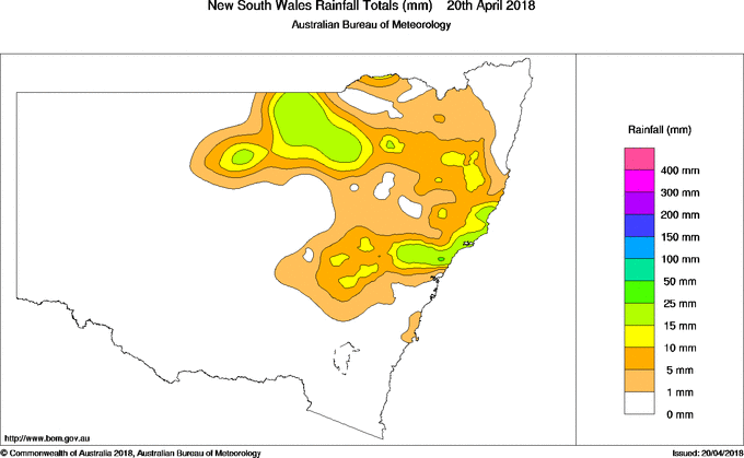
Thunderstorms flared up across central and northern New South Wales yesterday afternoon, bringing heavy rainfall as well as some reports of hail.
A low pressure trough fed by warm and humid onshore winds caused the storms to flare up from the afternoon, with the most widespread activity across the Central Tablelands, Mid North Coast, North West Slopes & Plains and Upper Western districts.
Whilst there were reports of small hail from Bathurst and in parts of the Hunter valley, the thunderstorms mainly brought much needed rainfall.
Over central-east NSW, some standout totals in the 24 hours to 9am included:
Broke: 35mm
St Albans: 46mm
Eleebana (Lake Macquarie): 35mm
Williamtown: 27mm
Nelson Bay: 26mm
Meanwhile, in northwest NSW Brewon recorded 70mm in the 24 hours to 9am today, whilst Lightning Ridge picked up 27mm and Barraba 28mm.
Showers and storms have cleared the regions today as the trough moves into northeast NSW and QLD.
Image: Rainfall in the 24 hours to 9am today (Source: Bureau of Meteorology)
Southeast QLD and north-eastern NSW experienced another day and night of significant weather with...
Showers, storms and cooler weather is on the way for many parts of New South Wales and Queensland...
If you woke up this morning, put on a singlet and shorts, and went running, I hope you ran back to...