Weather News Archive 2020 June
Image 1: Satelitte Imagery (Natural Color) of the low-pressure system sitting to the east of the...
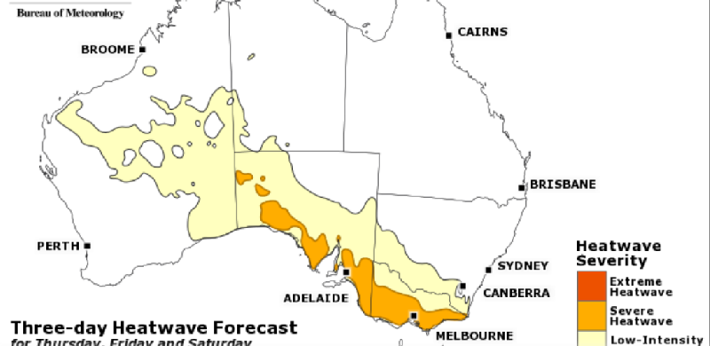
Image 1: National Three-day Heatwave Forecast
The hottest conditions since at least early February will affect southern australia over the next several days, as a slow moving wave of heat pools across the region.
A blocking high over the Tasman Sea and a lack of cold fronts will allow a low pressure trough to stretch from Western Australia through to Tasmania, causing a low-to-severe intensity heatwave to impact the region over late February and early March.
This area heat has been impacting the nation's west for a while now, with Kalgoorlie seeing its seventh straight day of 35 degree heat or above, with temperatures expected to soar into the mid 40s on Wednesday and Thursday. Catastrophic fire dangers are predicted in some areas of WA over the next two days due to associated strong winds.
Adelaide just sweltered through its third day in a row above 36 degrees and is set for at least four more, with Friday and Saturday set to reach around 40 degrees, the city's hottest days since the record heat in late January.
The heat will push into southern Victoria by tomorrow, with Melbourne forecast to reach at least 30 degrees on five consecutive days, including days in the mid-to-high thirties between Thursday and Saturday.
By early March, the hot airmass will dip into Tasmania, with Hobart pushing into the mid-to-high 30s on Saturday, with a chance of seeing its hottest day of the 'hot season' so far.
Cooler conditions should develop from later in the weekend or early next week as a cold front pushes the hot airmass into eastern and central Australia.
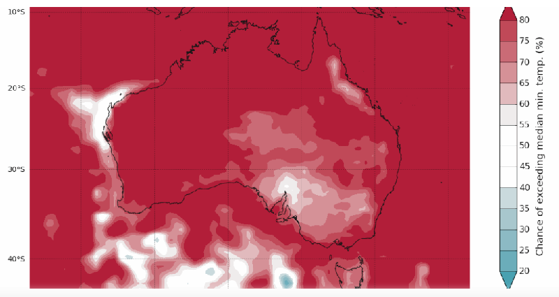
Image 1: Chance of temperatures exceeding median min. temperatures
Autumn 2019 in Australia is likely to see a continuation of warmer than average conditions across most of the country, while rainfall is expected to be lower across the nation's north.
While the Bureau of Meteorology still has Australia on an El Nino Watch, the National Oceanic and Atmospheric Administration (NOAA) has declared an El Nino, and these conditions are expected to have some influence over autumn in Australia, although its impact is historically reduced during autumn.
Apart from the northern Queensland floods, the Australian wet season was firstly delayed, and has largely failed for the remainder of Australia. Darwin and Broome have received only half of their entire December to February average so far, with only a week left of the month.
A similar pattern is likely to persist during autumn, with the El Nino influence expected to help contribute to lower than average rainfall across parts of northern Australia.
The lack of cloudiness and rain over the tropical north has manifested in well above average temperatures across the Australian continent throughout summer, and with this pattern continuing into autumn, the country can expect to see temperatures remaining above average.
The rainfall outlook for the rest of the country is less certain, with no strong indications towards wetter or drier conditions.
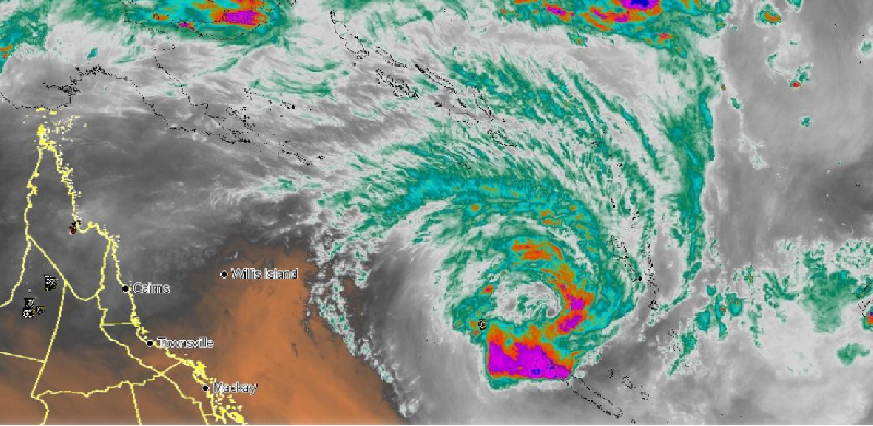
Image 1: Satellite Imagery - QLD Coastal Waters with Radar overlay
Tropical Cyclone Oma, currently a category 2 system is located west of Vanuatu and will gradually move south-west into Australian waters over the coming days.
As Oma continues to drift in a south-westerly direction towards the QLD coast, this system will combine with a ridge of high pressure and generate strong to gale force south to south-easterly winds across coastal areas from Central QLD to the Northern Rivers of NSW.
Whilst Oma isn?t expected to have a significant impact in regards to rainfall for the east coast at this stage, dangerous swells, large waves, beach erosion and abnormally high tides are expected, particularly from mid-week through until the weekend.
A similar pattern is likely to persist during autumn, with the El Nino influence expected to help contribute to lower than average rainfall across parts of northern Australia.
Island communities, exposed coastal locations and elevated terrain are likely to experience localised damaging winds gusts to up to and exceeding 90km/h mid to late week with coastal showers expected to develop.
At this stage, most models suggest that Oma will not strike the QLD coast, however model guidance is still unclear. Early indications suggest that Oma may be pushed south-east towards NZ as and upper trough moves across Australia.
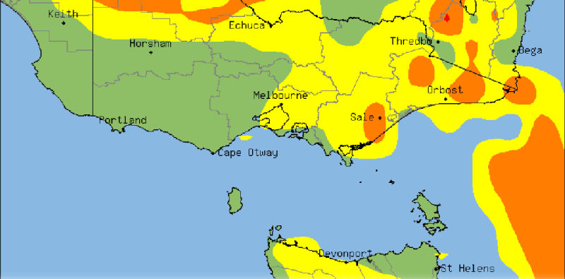
Image 1: Thunderstorm Probability - VIC/TAS
Severe thunderstorms are sweeping across western Victoria this afternoon and evening and are expected to develop over Tasmania from this evening, bringing much needed heavy falls to the bushfire ravaged states, which have also come off their hottest (and one of their driest) January on record.
A high over the Tasman Sea has been directing a humid onshore flow across southeastern Australia, allowing moisture to build over the region. A low pressure trough crossing the region has fed off this moisture, helping cause a line of thunderstorms to fire along the trough, which have been warned for the risk of flash flooding, large hail and damaging winds.
Thunderstorms have already brought heavy falls to western parts of Victoria this afternoon, with Longeranong picking up 27mm to 4pm (including 20mm in just 20 minutes), the town's best fall since November 2017. Stawell has recorded 12mm to 4pm, including 9mm in 9 minutes.
Thunderstorms and rain are also expected to develop over Tasmania this evening and into tomorrow, which will help immensely as fire fighters continue to battle blazes across the state that have been ongoing for weeks and have burnt almost 200,000 hectares. Many parts of the state are expected to see at least 20-to-30mm by tomorrow morning, however some parts of the north may see in excess of 100mm.
The Bureau of Meteorology has issued a severe weather watch for the state's north for heavy rainfall that may lead to flash flooding. Some locations may include, Burnie, Devonport, Sheffield, Deloraine.
Thunderstorms will be more isolated tomorrow and contract mainly to eastern Victoria, although a few thunderstorms remain a risk in Tasmania. A cold front will hit Tasamnia and southern Victoria later on Friday and into Saturday, bringing further showers and much cooler conditions, with falls of 10-to-30mm in western Tasmania.
Image 1: Satelitte Imagery (Natural Color) of the low-pressure system sitting to the east of the...
Image 1: Affected locations along the East Coast of QLD - November 29th, 2018
Image 1, current BoM radar at 12:05pm