Weather News 2020 November
Image 1: Operational Consensus Forecast max air temperature for Saturday 28/11/2020. Image via...
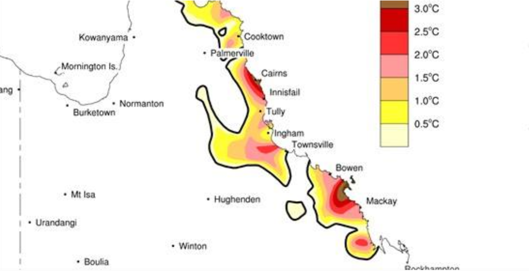
Image 1: Affected locations along the East Coast of QLD - November 29th, 2018
Large swathes of eastern Australia were hit by wild weather yesterday as a low pressure system affected the region, bringing record heat and catastrophic bushfire conditions in Queensland, and floods and severe winds in New South Wales, with both states also feeling the brunt of severe thunderstorms.
A complex low pressure system over NSW fueled the wild weather, with heavy rain and strong winds in its vicinity and to its south. Sydney CBD was drenched in almost 100mm of rain in just three hours between 6am and 9am EDT leading to an eventual 24 hour total of 105.6mm, its wettest November day in more than three decades.
Similarly heavy falls were recorded stretching from the Illawarra to the Hunter, with widespread totals of 40-to-90mm recorded in the 24 hours to 9am today. More exposed areas and those under thunderstorms experienced even higher totals, with notable totals including 189mm at Beaumont (west of Kiama), 124mm at Katoomba and 123mm at Mardi Dam (near Lake Macquarie). These totals lead to minor riverine flooding and flash flooding across the region.
The strongest winds were confined to the coast, particularly exposed areas, with gusts reaching 96km/h at Wattamolla, and 80km/h at Sydney Airport and Nobbys Head (Newcastle).
Numerous severe thunderstorms developed near the low and on the trough stretching from its northern flank. Large amounts of small hail was recorded in the Hunter district as several severe thunderstorms crossed the region. In northeast NSW, hail ranging from golf to tennis ball size was reported in the Byron Bay area, while Point Lookout off Stradbroke Island reported hailstones of a similar size.
Unfortunately, strong westerly winds wrapped around the northern side of this low, and combined with a hot airmass sourced from northwest Australia, bringing unprecedented heat and bushfire conditions to central and northern QLD. Onshore winds typically keep the hottest temperatures well inland at this time of the year in this part of the world, however with westerly winds strong enough to reach the coast, records were smashed by huge margins.
Cairns Racecourse exceeded 40 degrees four consecutive days in a row, including 43.6c on both Monday and Tuesday, smashing its previous November record of 37.2 degrees, and even beat its all-time record of 43.2 degrees (January 1923). Mackay exceeded 37 degrees an unprecedented five days in a row, including setting a new record for hottest temperature on record, reaching 39.7 degrees on Monday.
Strong and dry westerly winds lead to catastrophic bushfire conditions across parts of the state yesterday, with more than 100 fires still burning, a number of which reached emergency levels. Emergency services have been so strained with the demand, that services from interstate have been called in for assistance. Rockhampton was a good example of just how nasty conditions were, with the mercury at 2pm EST yesterday sitting a 43 degrees, with wind gusts reaching 70-80km/h and relative humidity of just 10 percent.
While conditions have eased in NSW, the heatwave over QLD is expected to continue and become even more widespread from now until at least early next week. However, the good news is that winds are expected to remain relatively light compared to yesterday (reducing fire danger), with onshore winds slowly picking up and increasing moisture levels through the weekend and into early next week.
There are indications by mid next week, there will be enough moisture to cause showers, rain and storms across bushfire affected regions, helping douse fires.
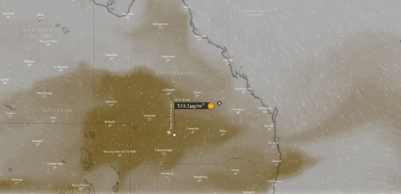
Image 1: Dust Mass via Windy - November 24th, 2018
Record November heat, strong winds and dust are set to impact parts of Queensland over the next week as a highly unusual weather pattern for this late in spring affects the state.
A winter-like setup is causing strong, dry and gusty westerly winds to extend well north for this time of the year, with humidity levels well below average across the state. November is typically a time of year where humidity gets increasingly higher across the state, fueling thunderstorms and rain. However, moisture levels are more typical of August than late November, although temperatures will be more typical of summer.
Gusty winds reaching 70-80km/h are set to whip up across many areas (especially the southern and central inland) tomorrow as a trough crosses the state, bringing another bout of dust across the state, with the thickest dust likely across the southern and central inland
Temperatures are also expected to reach the mid 30s to low 40s, and combining with the strong winds and low moisture levels, Severe Fire Danger is expected in the Capricornia, Central Highlands and Coalfields, Central West and Maranoa and Warrego forecast districts. The strong winds will encourage spot fires, which may spread any grass fires into more forested areas.
Rockhampton is set to see its first 40 degree day in November since 2004, with a maximum of 40 degrees expected. Moranbah and Longreach are forecast to hit 42 degrees, while Mackay will push into the mid 30s for the second consecutive day.
The longevity of the heat will mean some areas will set records for consecutive hot days for the month, as well average monthly November temperatures, with individual hot days less likely. However, individual day records were already broken today, with Mackay Airport reaching 37.8 degrees.
Rockhampton is expected to reach at least 39 degrees for the next four days, unprecedented in November, while Mackay is forecast to reach at least 35 degrees from Sunday through until at least next Friday, after exceeding this the last two days.
Not every day will see extreme fire conditions thankfully, with winds set to ease on Monday. However gusty winds will bring elevated fire danger again on Tuesday and particularly on Wednesday, which has potential for worse fire conditions than Sunday due to the risk of dry thunderstorms sparking fires.
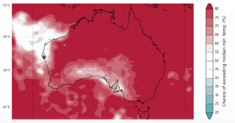
Image 1: Chance of exceeding median min. temp (%) - November 16th, 2018
The Bureau of Meteorology released their outlook for the Australian summer yesterday, and it is a mixed bag across the country. While most of the nation is expected to see hotter than average conditions, there is a higher chance of wetter than average conditions in parts of the east, and a higher chance of drier than average conditions in parts of the north and west.
Several climate drivers will influence the summer conditions across the nation, notably an El Nino event and a positive Southern Annular Mode.
Development towards an El Nino in the tropical Pacific Ocean continues, with El Nino conditions expected to persist throughout summer. The good news is that El Nino typically has a weaker influence in drought affected southeastern Australia during summer, although it will still have an impact on the northern Australian wet season with drier than average conditions expected
The El Nino event will however still lead to a higher probability of hotter than average conditions, with most of the nation expected to see above average daytime and night time conditions.
The Southern Annular Mode (SAM), which controls the north-south shift in westerly winds across Antarctica, is also expected to play a role. During a positive SAM event, higher than average pressure develops south of Australia, which encourages onshore winds across southeastern Australia, and hence increasing the chances of rain events. However, this pattern can also lead to an increased likelihood of prolonged heatwaves across SA, VIC, TAS and southern NSW.
The positive Indian Ocean Dipole event, which generally causes decreased rainfall across large parts of the country, is expected to end by December and should not be a major influence during the Australian summer.
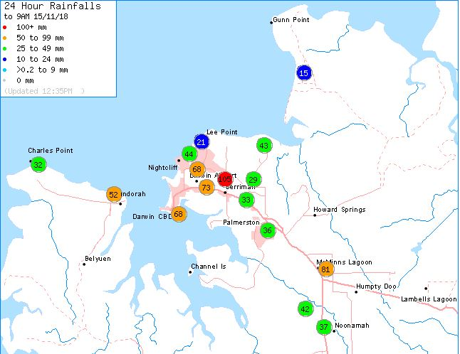
Image 1: 24 hour rainfall totals - Darwin - November 15th, 2018
The latter part of the 'Build up' is in full swing across the Top End, with oppressive conditions during the day and night often breaking to showers and thunderstorms, bringing relief.
Yesterday was such a day as the mercury reached 35 degrees in Darwin, with humidity making it feel 2-3 degrees hotter, and temperatures remaining around 30 degrees late into the evening and humidity around 80 percent.
However, the oppressive conditions finally gave way to thunderstorms just after 10:30 pm local time, with multiple thunderstorms affecting the region throughout the night and into the morning.
The thunderstorms brought a spectacular lightning show and the heaviest rain in months to some areas, with Darwin airport's 73.2mm to 9am the biggest fall since January (including 32mm between 4am and 5am) and nearby Berrimah collecting 105mm.
Gusty winds were also recorded, reaching 60-70km/h at some stations across the Top End.
Early morning thunderstorms are again a good chance for the Top End tonight.
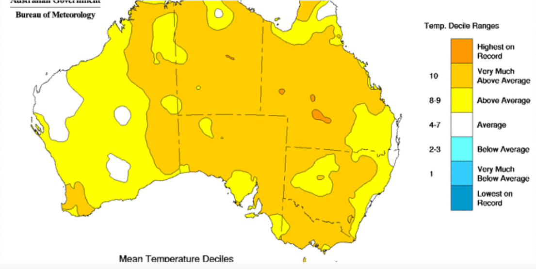
Image 1: National Mean Temperature Deciles - November 9th, 2018
October was yet another warm month across Australia, continuing the trend seen so far this year, with much of the country seeing much warmer than average conditions.
Across Australia as a whole, mean temperatures were 1.83 degrees above average (when combining both maximum and minimum temperatures), with night time temperatures contributing strongly to this (second warmest on record across Australia). However daytime temperatures were still 1.84 degrees above average, the ninth warmest on record.
This may come as a surprise to some parts of the country, with those in eastern NSW and southeast QLD seeing cooler than average daytime temperatures, particularly early in the month where some had their coolest start to the month in a few decades.
Whilst the warm trend continued, October finally bucked the trend of drier than average conditions, with rainfall 11% above average across the nation. For parts of NSW and Queensland, this helped significantly in drought relief, although was not enough to break the drought.
Some isolated parts of New South Wales, Queensland and Western Australia even recorded their wettest October on record. However, those in the south of the country missed out, with Tasmania seeing its third driest October on record.
Warmer than average conditions are expected to continue into November
Image 1: Operational Consensus Forecast max air temperature for Saturday 28/11/2020. Image via...
Image 1. Access R forecast rainfall 8am Wednesday 1st August. Image 2. EC wind gusts 10am 1st...
Image 1: Satelitte Imagery (Natural Color) of the low-pressure system sitting to the east of the...