Weather News Archive 2019 November
Image 1: 850 temperatures across Australia on Monday 2nd December, 2019. Source: Pivotal Weather
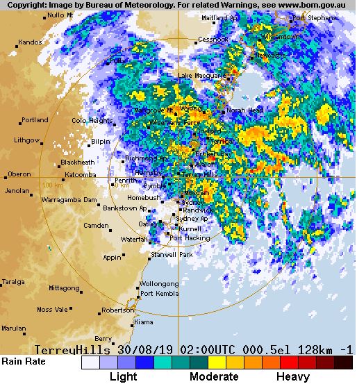
Image 1, current BoM radar at 12:05pm
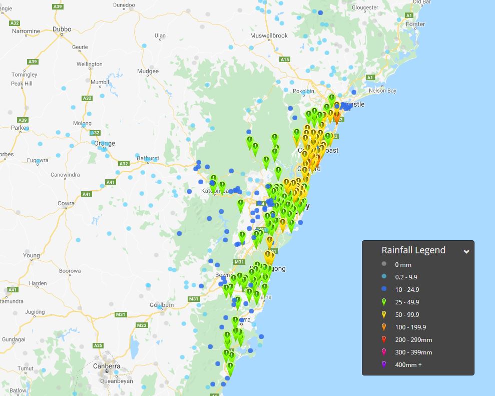
Image 2, EWN rainfall totals 24 hours to 9am 30th August, 2019
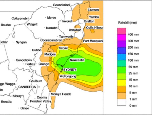
Image 3, BoM PME forecast rainfall for Friday 30th August, 2019
%203%20day%20accumulated%20precipitation.jpg)
Image 4, EC (Windy.com) 3 day accumulated precipitation
Heavy rainfall has lashed coastal parts of NSW overnight, with falls in excess of 100mm recorded at multiple locations in the 24 hours to 9am this morning.
The coastal trough responsible for the downpour, developed across coastal NSW in response to an upper cold pool of air that has been drifting across the state. This system is expected to linger over the next 24-48 hours with further moderate to heavy falls likely.
Gosford in the Hunter region, recorded the highest total to 9am this morning with 114mm, making it the wettest August day since 2007. Avoca Reservoir received 105mm, Ettalong Public School 107mm, Blacksmiths 109mm and Norah Head picking up 54mm.
In the Illawarra region, Bellambi AWS region picked up 75mm, whilst Sydney (Observatory Hill) scored 43mm to 9am this morning. Sadly, the heavy falls haven't extended far from coastal regions, with Bathurst registering just 5mm, Parkes AP 1.4mm and Scone 1mm.
Further totals of 30-50mm are likely across coastal parts of NSW from the Mid North coast to Illawarra region today, which may lead to localised flash flooding throughout Friday. This activity should slowly contract north during the afternoon hours.
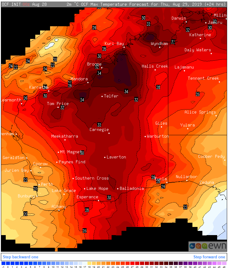
Image 1, OCF Forecast temperatures over WA on Thursday 29 August, 2019
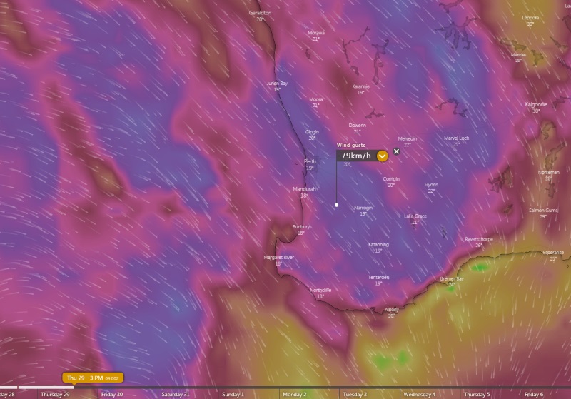
Image 2, Forecast wind gusts over southwest WA at 3pm Thursday 29 August, 2019 (Source: Windy)
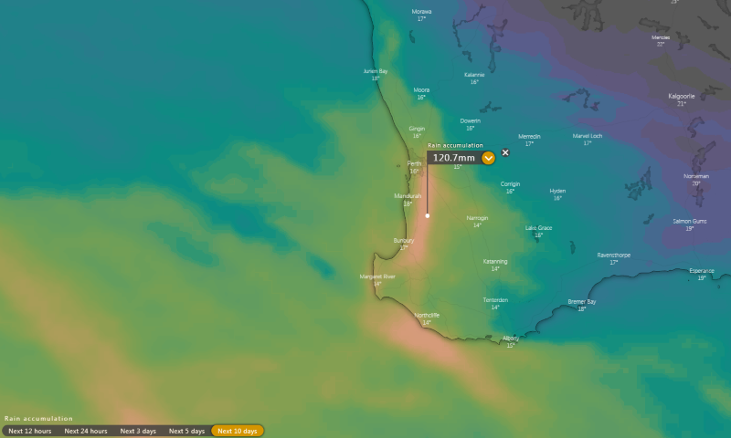
Image 3, Accumulated precipitation over the next 10 days (Source: Windy)
Sunny skies and record August warmth has affected southwest parts of Western Australia today, however a vigorous cold front is set to bring a rapid change in weather from Thursday, with heavy rainfall and thunderstorms likely to hit the region over multiple days.
The mercury has soared to 29 degrees over the Perth metropolitan region today, shattering previous records for August. Perth city has reached 29.3 degrees as of 2pm local time, beating the previous record of 27.8 degrees set in 1940
Tomorrow, this heat will shift east, with Kalgoorlie forecast to reach 31 degrees, just 1 degree shy of its August record. Strong, gusty winds to 60-80km/h will also accompany this warmth tomorrow ahead of a strong cold front approaching off the Indian Ocean. This wind combined with the warmth is likely to lead to elevated fire danger and the risk of a number of fires breaking out.
Those in coastal areas will be much cooler than today, with showers developing from the late morning. These will increase by the evening as the front hits, with the risk of thunderstorms and locally heavy falls, as well as strong and gusty northwesterly winds, especially over coastal and elevated areas.
This front will be the first in a series of fronts to hit the southwest over the next week, with showers and possible thunderstorms a risk on almost every day starting from tomorrow, until next Wednesday. Widespread falls between 50 and 100mm are likely over this period, with isolated totals of 150-200mm.
Conditions will also be much cooler as a result, with temperatures in the mid-to-high teens or low 20s.
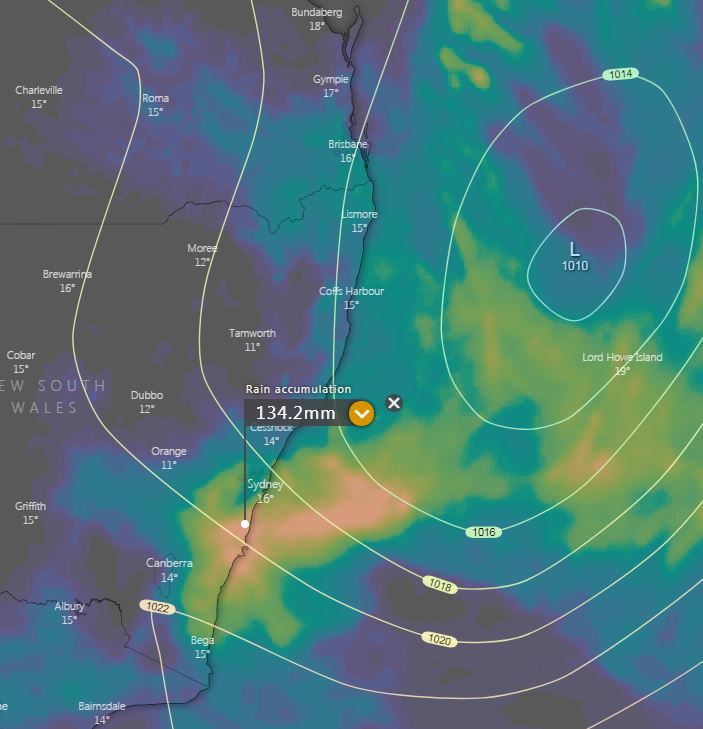
Image 1, Accumulated precipitation next 5 days (Source: Windy)
Image 2, Large cut-of low across NSW (Source: Weather.us)
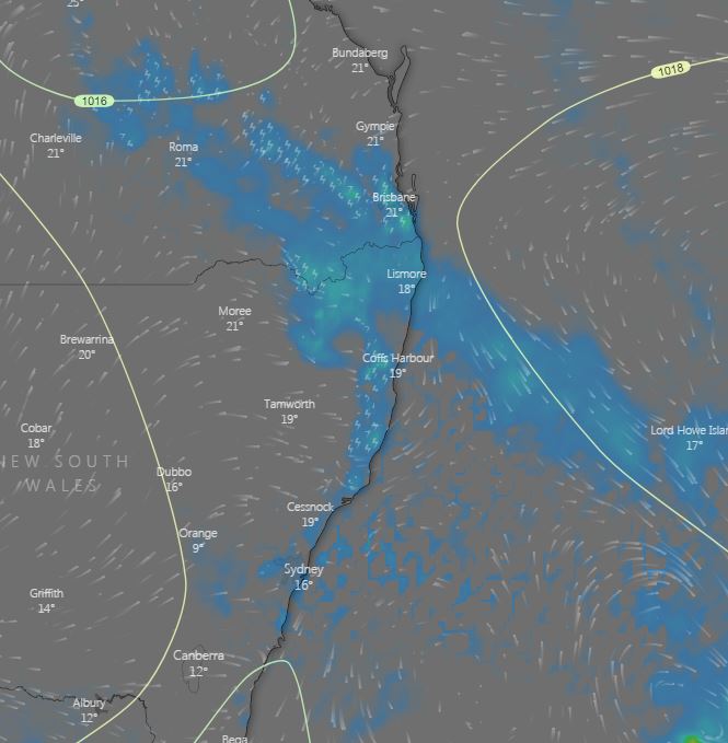
Image 3, Afternoon showers and storms across northern NSW and southern QLD (Source: windy)
Wet weather is expected to finally return across eastern NSW and southern QLD this week, with the potential for moderate falls to develop across the NSW coastline.
Monday through to Wednesday, a surface trough and upper trough will combine to produce weak instability across northern NSW and southern QLD. This is expected to lead to afternoon showers and weak storm activity. Small hail may develop, particularly during Wednesday, as very cold air aloft associated with the upper trough moves over the region.
During Thursday, a cut-off low is expected to shift north-east into NSW, potentially inducing a small low pressure system/coastal trough off the central NSW coastline. Should the scenario unfold, showers, rain period and isolated thunderstorms would be expected with moderate to locally heavy falls possible.
Widespread falls of 10-25mm are expected for coastal regions from the Hunter south to the Victorian border, with the potential for localised falls exceeding 100mm during the next 7 days.
Whilst most of the more significant rainfall will be confined to coastal regions and adjacent inland locations, light falls are expected for inland locations.
Strong winds and powerful surf conditions will once again pound the southern NSW coastline as that weak low develop, before moving off into the Tasman Sea towards NZ next weekend.
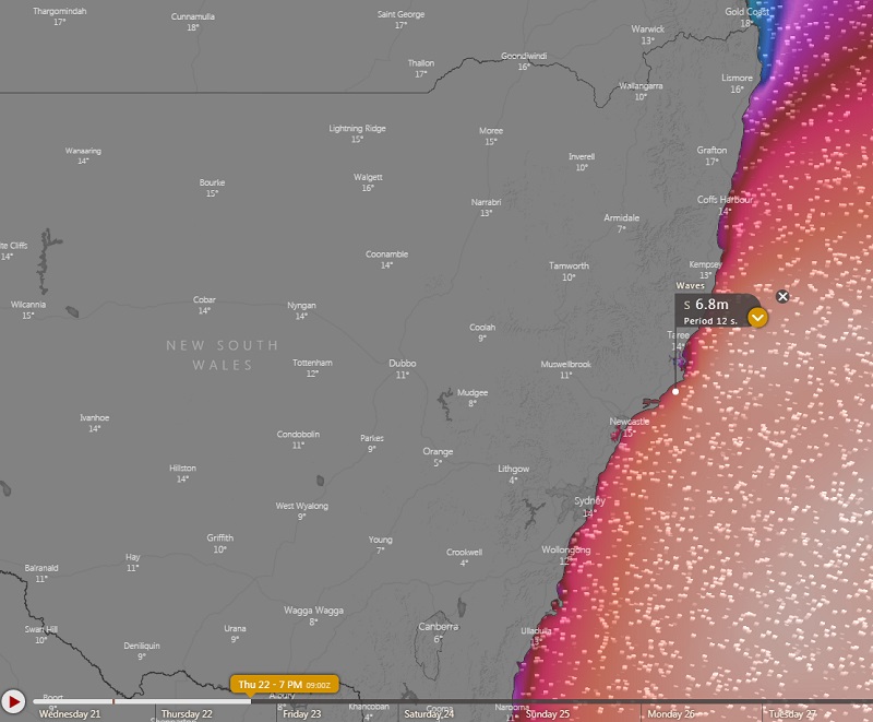
Image 1, Forecast wave heights for Thursday 22 August, 2019 (Source: Windy)
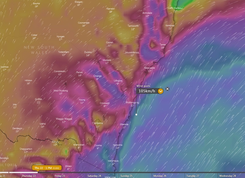
Image 2, Forecast Wind gusts for the NSW coast tomorrow afternoon (Source: Windy)
The New South Wales coastline is set to be smashed by huge surf tomorrow, with waves set to reach 5-7 metres, leading to the risk of significant beach erosion.
A complex low pressure system over the Tasman Sea and an associated vigorous cold front will send a significant southerly swell over the state's coastline.
A hazardous surf warning is currently in place between the Eden and Macquarie coasts today, however the surf is expected to get noticeably bigger tomorrow with a large nunber of beaches likely to be closed, with the warning extending northwards to the Byron Coast.
About some exposed southern beaches (such as around Seal Rocks), wave heights will reach towards 6-7 metres, while elsewhere wave heights will reach closer to 4-5 metres. This is likely to lead to the potential of signifcant erosion on some beaches.
As the system surges north tomorrow, the coast is also likely to be battered by strong winds reaching 60-70km/h with potential for gusts to 90km/h on more exposed beaches. Offshore, gusts are likely to exceed 100km/h.
While there will be some easing, dangerous surf conditions will persist into Friday, before easing further over the weekend as the system moves away.
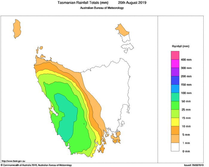
Image 1, Rainfall in the 24 hours to 9am today (Tue 20th August) over Tasmania (Source Bureau of Meteorology)
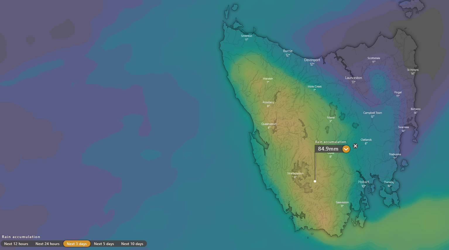
Image 2, Rainfall accumulation across the next three days over Tasmania
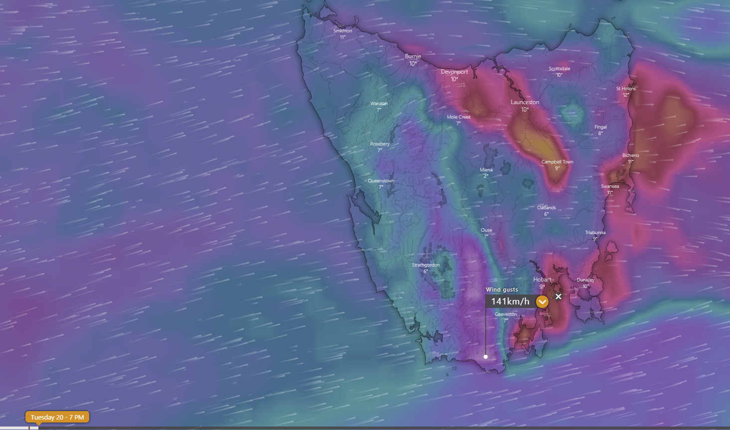
Image 3, Wind gust forecasts for Tasmania for 7pm Tuesday 20 August, 2019
A barrage of cold fronts has been producing some cold, wet and windy weather over Tasmania over the last couple of days, with the wild weather likely to continue for the remainder of today and into tomorrow.
The western half of Tasmania has been drenched over the last two days as an unstable and vigorous westerly airflow affected the region.
In the 24 hours to 9am on Monday, 30-50mm was recorded, whilst in the 24 hours to 9am today, 50-100mm was recorded (with isolated higher falls, including 111mm at Darwin Dam).
As another two fronts affect the state this afternoon and again tomorrow, further rainfall accumulations of 40-80mm are likely, with isolated higher falls.
Strong winds are also likely to accompany these fronts, with a severe weather warning out for much of the state for the remainder of today and tomorrow for gusts to 100-110km/h. About more exposed parts of the ranges and southern coast, gusts of up to 130-140km/h are possible.
Conditions will ease from Thursday as a high pressure system takes hold.
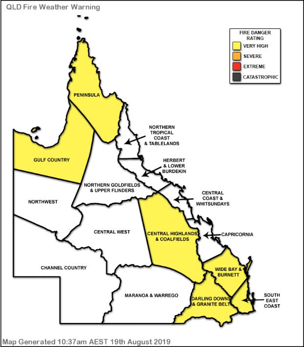
Image 1, EWN generated fire danger rating QLD
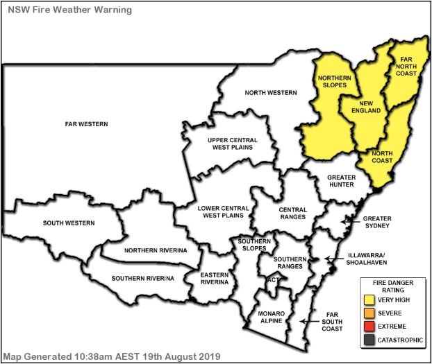
Image 2, EWN generated fire danger rating NSW
An advancing cold front will shift off the east coast of Australia today, with north-westerly winds ahead of the front, turning south-westerly in its wake.
Gusty winds, warm temperatures and low humidity, coupled with drought conditions will lead to increasing fire dangers across southern QLD and northern NSW during Monday.
Temperatures are expected to be well above the August average, with both Brisbane, Ipswich, Beaudesert and Gympie all heading for a top of 28C, putting them 4-5C above average.
A similar situation is unfolding across northern NSW, with Lismore heading for 26C, Grafton 26C, Ballina 25C and Kempsey 24C.
Total fire bans are in effect for The Scenic Rim, Ipswich, Logan and Lockyer Valley Council regions throughout Monday.
With no significant rainfall on the horizon, and a warm spring expected, the next couple of months may be rather nasty on the fire front across eastern QLD and NSW.
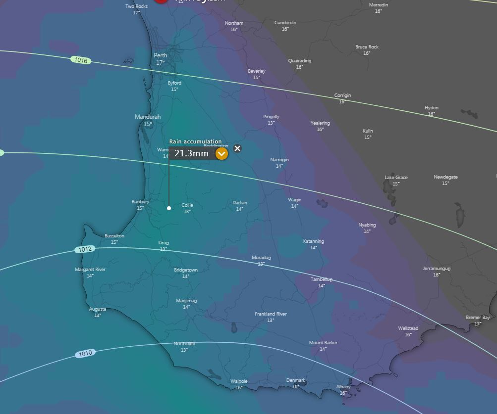
Image 1, EC rainfall totals next 24 hours via windy.com
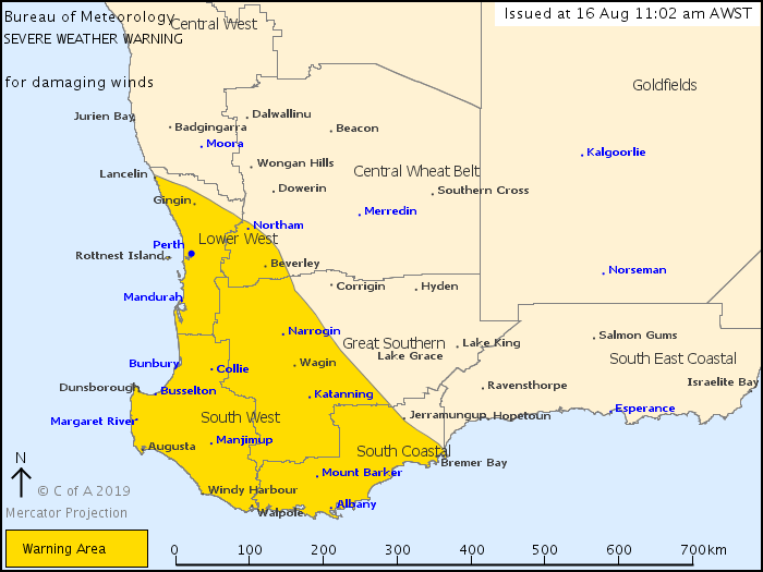
Image 2, BoM, current severe weather warning
Image 3, BoM Access model showing small pixels of potential snow into Saturday morning
A strong cold front will sweep across the South West Land Division of WA this afternoon and overnight, producing a large band of showers and thunderstorm with its passage. Damaging winds of up to 100km/h may develop with shower and storm activity this evening and overnight.
In the wake of this front, a very cold airmass will invade the region with small hail likely with shower and storm activity, along with the potential for a couple of centimetres of snow across the Stirling Ranges during Saturday morning.
Rainfall totals of 15-25mm are expected during the next 24hrs, providing perfect follow up rainfall from earlier this week.
A severe weather warning has been issued for the South West Land Division, extending from Lancelin in the Lower West, to Bremer Bay in the South Coast.
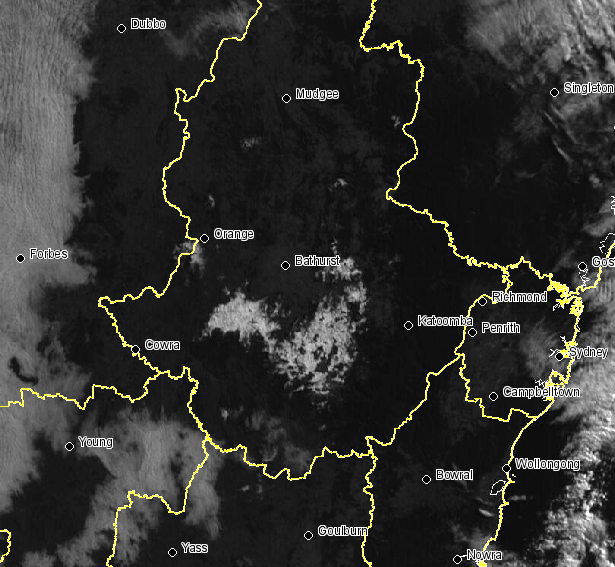
Image 1, snow visible on satellite image over the NSW Central Tablelands
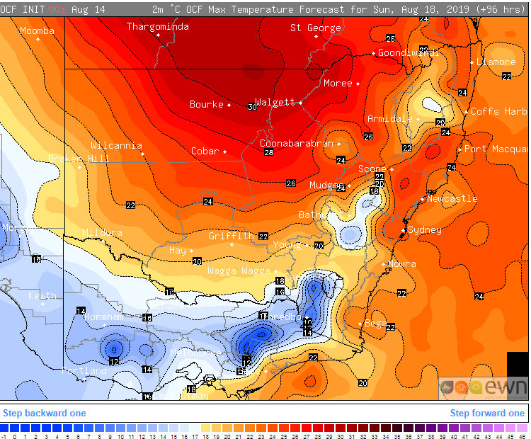
Image 2, OCF Forecast temperatures on Sunday 18 August, 2019
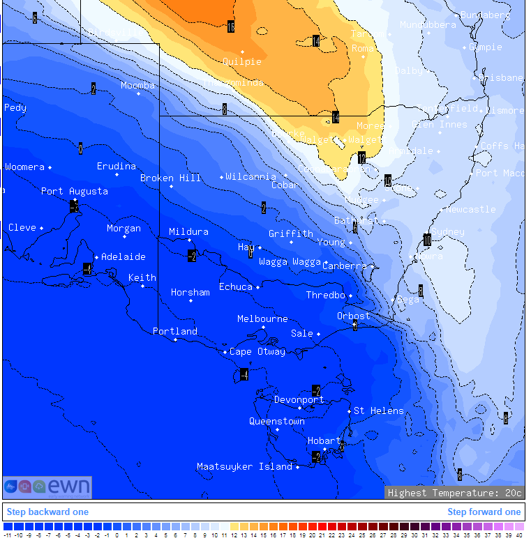
Image 3, 850mb forecast temperatures over southeastern Australia on Sunday 18 August, 2019
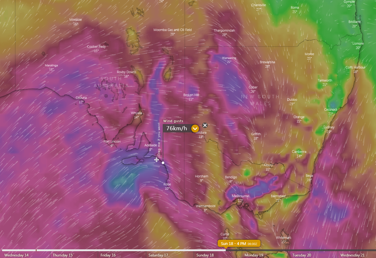
Image 4, Forecast wind gusts for Sunday 18 August, 2019
Temperatures are warming up this week after a cold blast affected the nation's southeast last weekend, although this won't last for long as another cold blast is set to arrive late on the weekend and into early next week.
The cold front last weekend caused snow to fall to low levels across parts of Tasmania, Victoria and New South Wales, with snow extending up close to the Queensland border.
Some parts of NSW Central Tablelands saw in excess of 20cm of snow, with satellite images showing a visible cover days after the event finished. Spencers Creek has now reached 2 metres for the first time this season, slightly earlier than when this depth was reached last year.
Conditions will be much more settled and warmer this week, with temperatures reaching into the mid-to-high teens over VIC and TAS, low 20s in SA, and low-to-mid 20s across NSW. Those in northeast NSW and southeast Queensland will see temperatures reaching the high 20s by the weekend or early next week, with some locations possibly reaching into the low 30s.
However, the cold blast, which is expected to be not as strong as the last system, will sweep across the southern states on Sunday, before reaching the remaining states by Monday or early Tuesday. Ahead of the front, strong dry and gusty winds are likely, with bushfire danger also elevated.
With and behind the change, showers, thunderstorms, small hail and snow are likely, with snow possibly falling to low levels again across parts of VIC, TAS and NSW (although it is not expected to extend as far north as the previous system).
Unfortunately, the system is not expected to bring widespread or significant rainfall, with the highest totals likely about the coast and ranges of TAS, VIC and southern NSW.
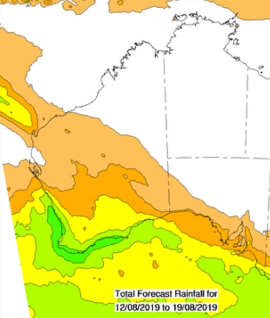
Image 1, BoM PME 8 day rainfall accumulation.
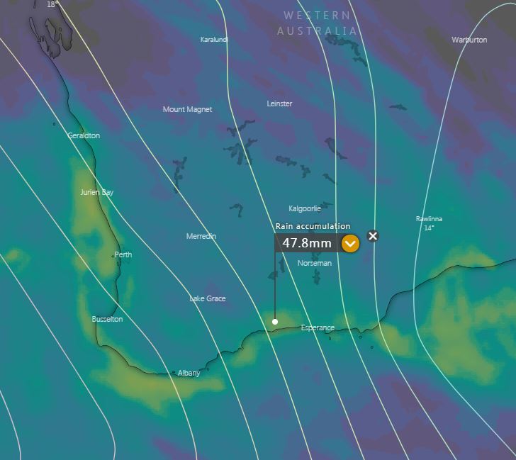
Image 2, EC rainfall totals, next 10 days (windy.com).
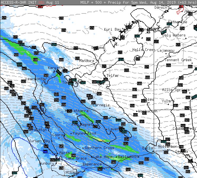
Image 3, Access R precipitation values, Wednesday afternoon.
Showery conditions are expected to return across the South West Land Division of WA during Tuesday and into Wednesday.
A cold front and associated trough will generate showers across coastal regions during Tuesday morning, becoming more widespread during the afternoon and spreading east into inland regions.
During Wednesday, very cold upper level temperatures will interact with increasing moisture to generate cloudy conditions, scattered showers, rain periods and isolated thunderstorms.
A small surface low may develop during Wednesday, with widespread falls of 10-15mm are expected, with isolated falls to 30mm, particularly with thunderstorm activity during the afternoon.
Conditions will gradually clear during Thursday, before the next frontal system approaches the South West late on Friday, with showers and isolated thunderstorms increasing.
These falls are likely to be extremely welcome across the Agricultural districts, with some areas potentially seeing up to 50mm during the next 7 days.
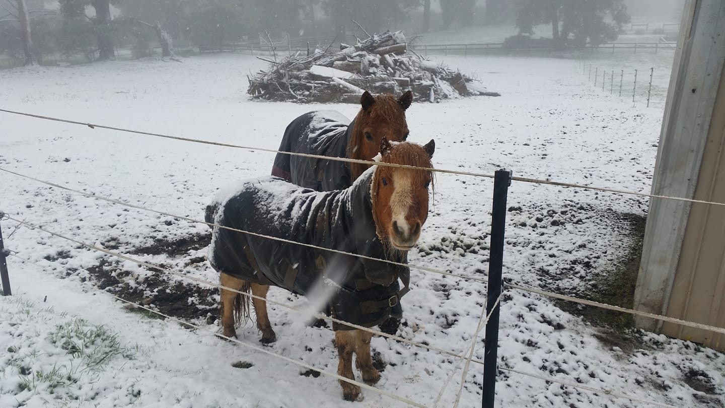
Image 1: Kylie Hocking at Pheasant Creek, Victoria
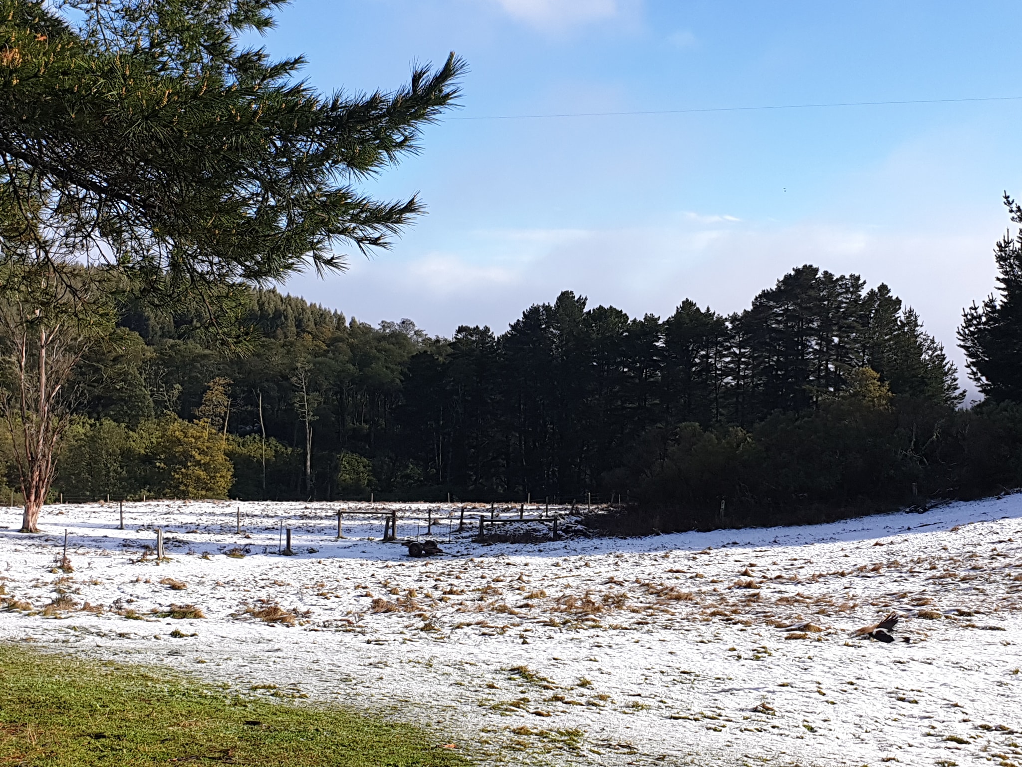
Image 2: Kylie Snape in Blackwarry, Victoria.
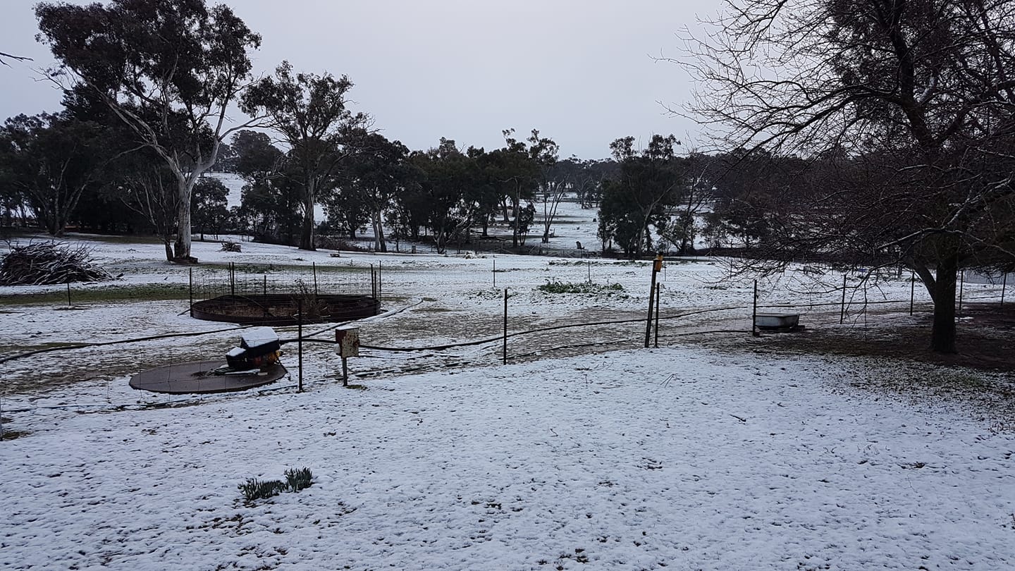
Image 3: Carolyn Austin-Lillyfields Alpacas in Browning, NSW.

Image 4: Via Twitter from Snowsearch Australia at Falls Creek, NSW.
A complex low pressure system and associated cold fronts have produced a stunning polar blast across southern Australia over the last 72 hours.
Low level snow down to 400m has fallen across parts of VIC, ACT and NSW, producing a stunning winter wonderland.
The Blue Mountains has been blanketed in snow with spectacular images coming out of Orange, Katoomba and Oberon where as much as 10cm of snow has fallen. Meanwhile, across the ski resorts, Thredbo has recorded a staggering 137cm of snow since this system began.
Snow flurries pushed north yesterday evening, settling across parts of the Northern Tablelands of NSW, with Guyra, Walcha and Armidale seeing snow flurries.
In Victoria, Falls creek has registered over 1 metre of snow, whilst the outter suburbs of Melbourne, including Gisborne and Olinda has received snow flurries this morning.
Friday night, the Hawthorne vs GWS game in Canberra created history to become the first AFL game to have snow falling during an event, which was a spectacular scene for many, even the players were visibly excited by the event.
During Sunday, further snow is expected for the ski resorts in VIC and NSW, with low level snow slowly shifting to higher terrain throughout the day. Further flurries are expected across parts of the Northern Tablelands in NSW and maybe even creeping up to Stanthorpe in southern QLD this evening.
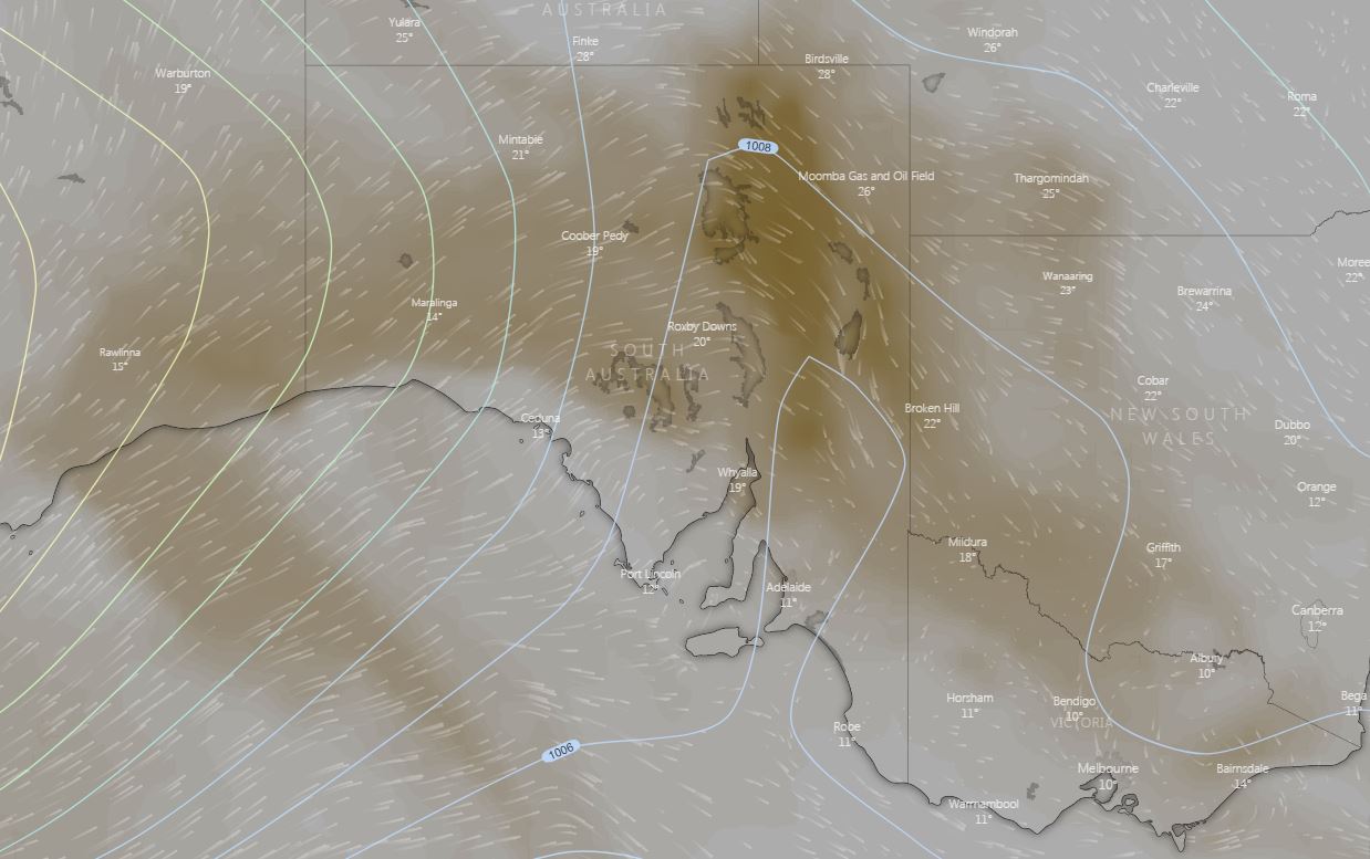
Image 1: windy.com dust output for Wednesday afternoon 7/08/2019
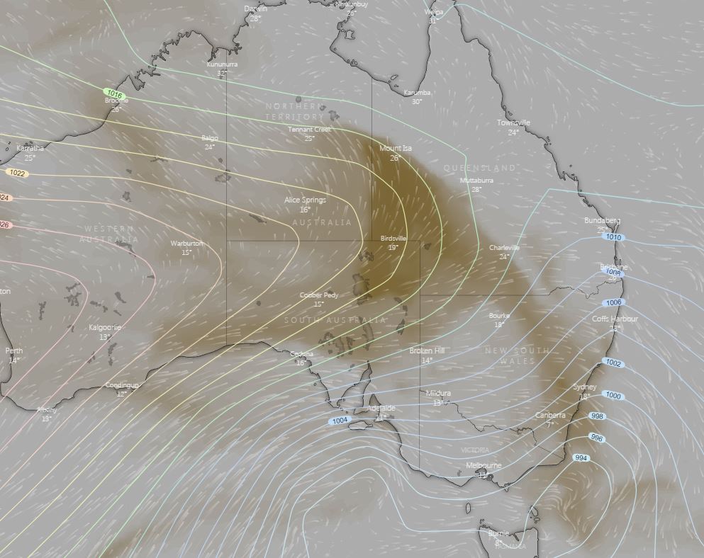
Image 2: Windy.com dust output for Thursday 8/8/2019
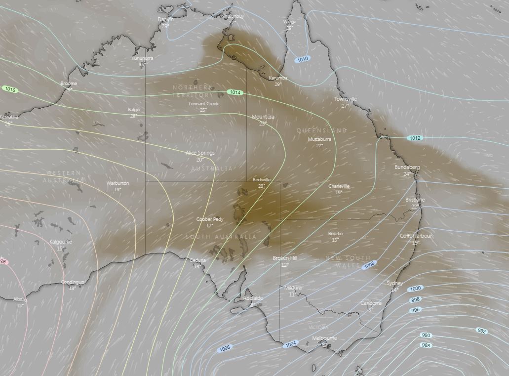
Image 3: Windy.com dust output for Friday 9/08/2019
A series of cold fronts associated with a strong low pressure system across southern Australia are set to whip up dusty conditions late this week for inland parts of the country.
A dry and gusty south-westerly airstream will invade parts of SA, VIC, NSW, NT and southern QLD over the next 12 hours, before reaching the east coast during Thursday.
With favourable conditions expected, areas of raised dust may develop for north-eastern parts of SA this afternoon, before spreading into western NSW, QLD and southern parts of the NT.
Late Friday, hazy skies may develop for eastern parts of NSW and QLD, with the potential for dust to be pushed up into eastern parts of the Top End of NT and Gulf region of QLD.
Dusty conditions may lead to an increase in allergies, particularly asthma sufferers. Conditions are likely to continue into the weekend, before gradually easing early next week as a large high pressure system moves across southern Australia.
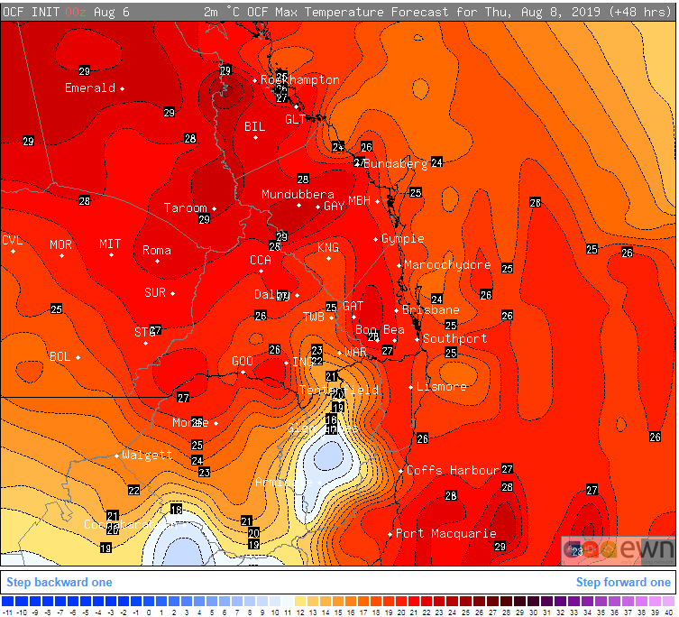
Image 1: OCF Forecast temperatures for northeast NSW and southeast QLD on Thursday 8th August, 2019
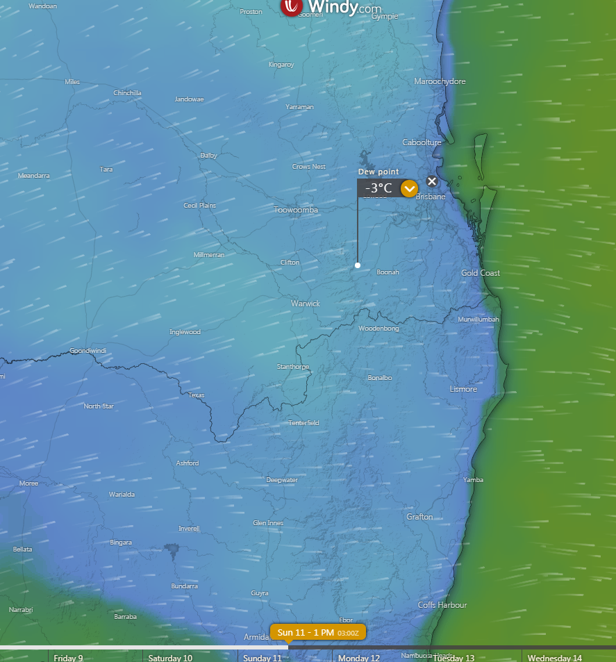
Image 2: Dew point forecast for Sunday 11th August, 2019 (lower these values = lower the humidity) Source: Windy
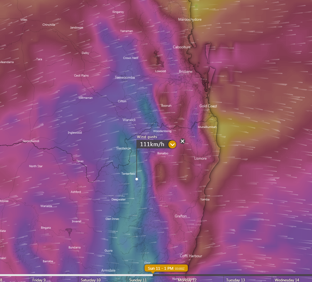
Image 3: Wind gust forecast (damaging wind gusts) for northeast NSW and southeast QLD on Sunday 11th August, 2019 (Source: Windy)
Warm, dry and windy conditions will cause fire danger to spike across northern New South Wales and southern Queensland later this week, ahead of a cold blast set to hit the nation's southeast.
Temperatures will push into the mid-to-high 20s on Thursday across the region (off the ranges), which typically happens once (on average) every few years this early in August, before cooling into the mid 20s on Friday.
Westerly winds (typical for this time of the year, also known as the 'Ekka winds') will accompany the warmth. However prolonged dry conditions, a very dry airmass and stronger than normal winds will cause fire dangers to spike to conditions higher than normal for this time of the year.
Conditions are ripe for fires, after a very dry start to the year, with potential for fires to start and spread quickly due to the very dry fuel load. Amberley (Ipswich) has only received 220mm for the year so far, less than half its average rainfall, while Brisbane has recorded 370mm, so far for the year (average 635mm).
The QLD Granite Belt and NSW Northern Tablelands have also been struggling immensely and are in the grips of one of their worst droughts in history, with Stanthorpe only recording 120mm so far this year (average to the end of July is 431mm). If no significant rain is received in the near future, the town will run out of water by the end of spring. Glen Innes has recorded just 200mm so far this year, well short of the average of 466mm to the end of July.
While the airmass will cool further on Saturday and Sunday, with even potential for some snow flurries on the tablelands, strong winds and a very dry airmass will likely keep the potential for fires elevated, mainly over the coastal plain, before conditions ease on Monday.
Image 1: 850mb temperatures over Australia on Saturday
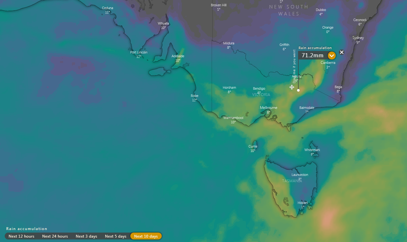
Image 2: Rain accumulation across southeastern Australia over the next 10 days (Source: Windy)
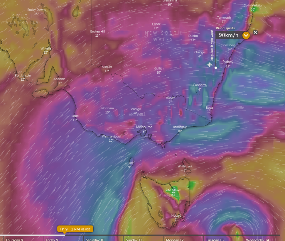
Image 3: Wind gust forecast for southeastern Australia on Friday (Source: Windy)
Winter is returning to southeastern Australia after the region endured one of its warmest Julys on record, with a series of cold fronts set to bring showers, hail, snow and strong winds this week.
The first of these fronts are expected to impact Tasmania from tomorrow, before another stronger front will impact Victoria, South Australia and New South Wales on Wednesday and Thursday. This front is expected to contain the most moisture, and produce much needed rain, with widespread fals of 10-to-20mm across northern Tasmania, much of Victoria and the southern NSW ranges, with localised falls up to 50mm. Snow above 800m is also likely, as well as the risk of thunderstorms and small hail. Wind gusts reaching 90-100km/h are also possible, particularly about coastal areas and the ranges.
Further heavy showers are likely to persist across coastal and northeast NSW and the southern NSW ranges on Friday. However, the coldest airmass will also surge across the region on Friday and Saturday as a low deepens to the east of Tasmania, with snow lowering possibly down to 500-600m across TAS, VIC and southern NSW. By the end of the week, snow resorts will likely have received 40-80cm of fresh snow, with some of the higher resorts likely to have a natural base of more than 2 metres. Snow is also likely over the NSW Central Tablelands, including the Blue Mountains. Friday will be the windiest day in NSW, with wind gusts reaching 90-100km/h across many areas, particularly the ranges.
The cold airmass will surge as far north as the NSW Northern Tablelands over the weekend, with some indications of a dusting of snow possible around Guyra. Unfortunately, the system will have lost a lot of its moisture by this stage, with substantial rain unlikely in a region struggling with drought.
Those off the ranges are still likely to feel the cold, particularly due to the added chill from wind. Sydney will reach around 17-18 degrees on Friday and into the weekend, however the wind chill will make it feel 4-5 degrees colder.
Cool conditions (particularly widespread frost) will linger into next week, before warmer conditions develop from mid-August.
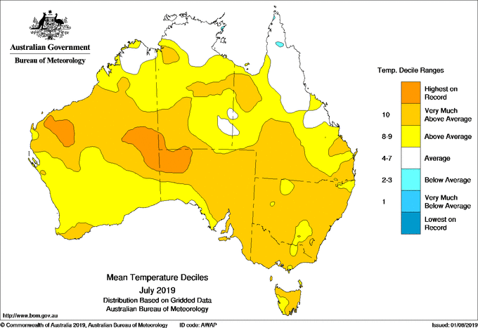
Image 1: Temperature deciles for July across Australia
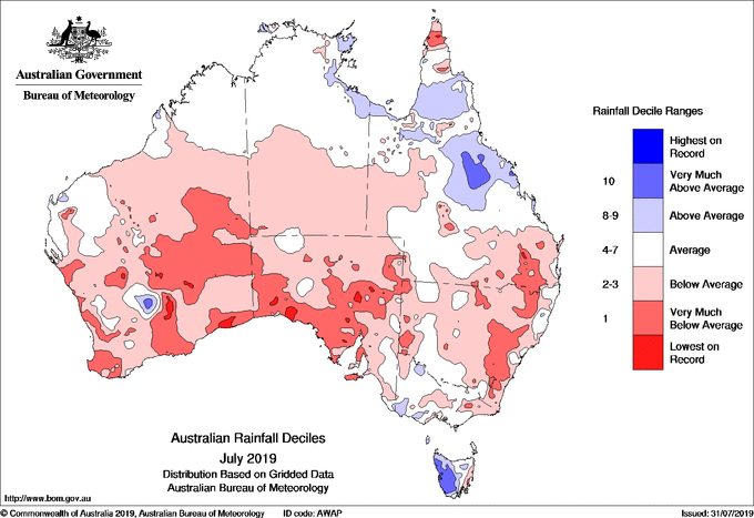
Image 2: Rainfall deciles for July across Australia
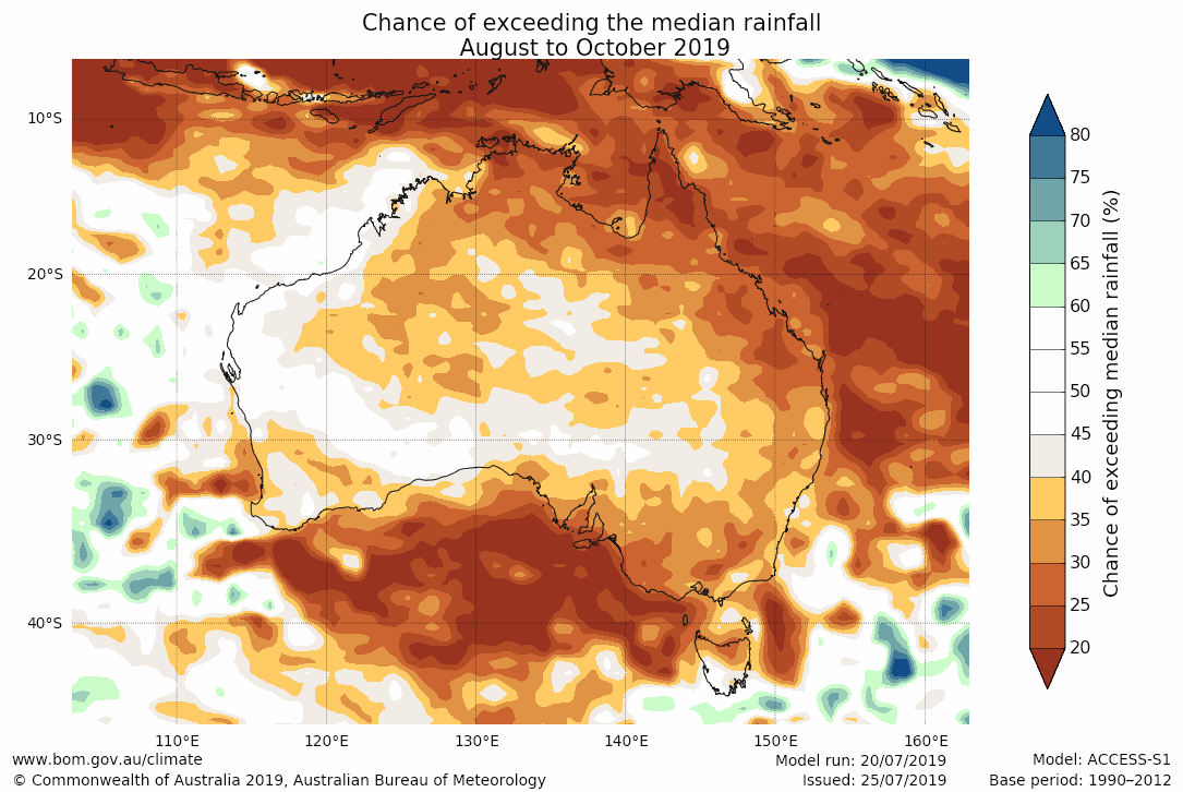
Image 3: Rainfall outlook for August-October in Australia
Australia has recorded yet another unusually mild and dry July, providing no relief to the drought conditions gripping large areas, as the country struggles through its fifth driest start to a year on record.
Mean temperatures were above average for nearly all of the country, as persistent high pressure kept cloudiness and rainfall lower than normal, with the national mean temperature 1.62 degrees above average.
More remarkably, daytime temperatures were the third highest on record for July (+2.23c), following the second highest on record in 2018, and the highest on record in 2017. Night time temperatures were around 1.01 degrees above average.
Due to persistence of high pressure, rainfall was also very much below average, with Australia recording its 12th driest July on record, with a number of sites in QLD, SA, NSW, VIC, SA and WA registering their lowest July totals. However, a few sites in western Tasmania recorded their wettest July on record.
2019 has been a poor start for agriculture across the nation, with Australia now seeing its fifth driest January to July period on record, and second warmest. A number of locations across country NSW and QLD have less than a years supply left of water in their dams. Unfortunately, dry and warm conditions are expected to continue into spring.
Image 1: 850 temperatures across Australia on Monday 2nd December, 2019. Source: Pivotal Weather
Image 1: Satelitte Imagery (Natural Color) of the low-pressure system sitting to the east of the...