SE QLD severe storm analysis for Sunday 17th November, 2019
On Sunday 17th November 2019, a significant thunderstorm outbreak occurred across South East QLD....
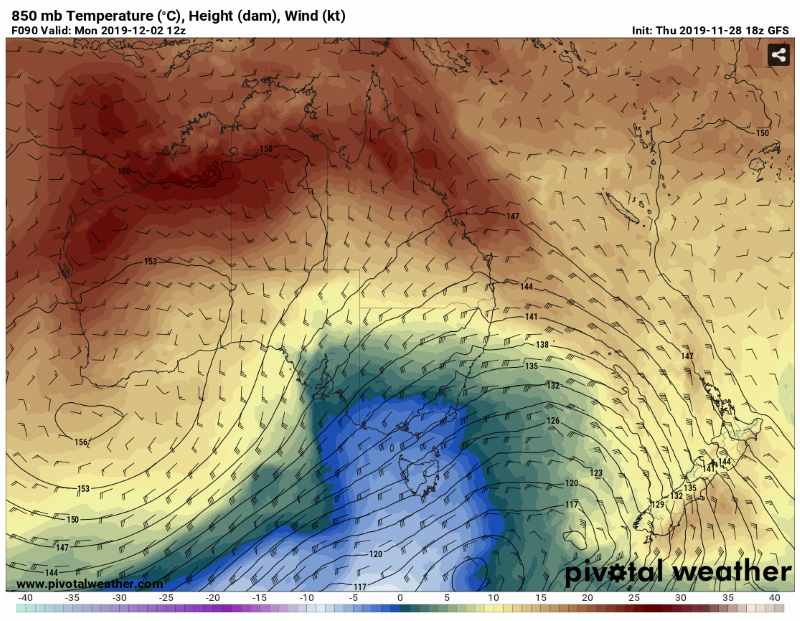
Image 1: 850 temperatures across Australia on Monday 2nd December, 2019. Source: Pivotal Weather
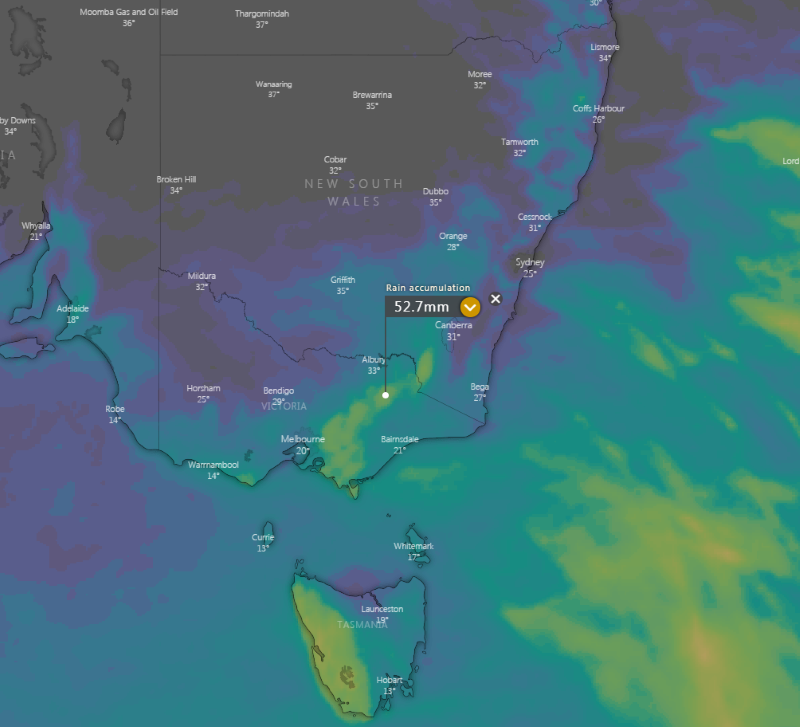
Image 2: 5 day rain accumulation. Windy.com
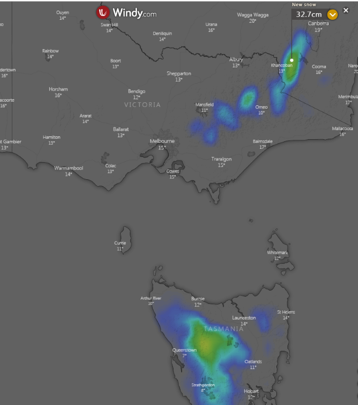
Image 3: 5 day snowfall accumulation. Windy.com
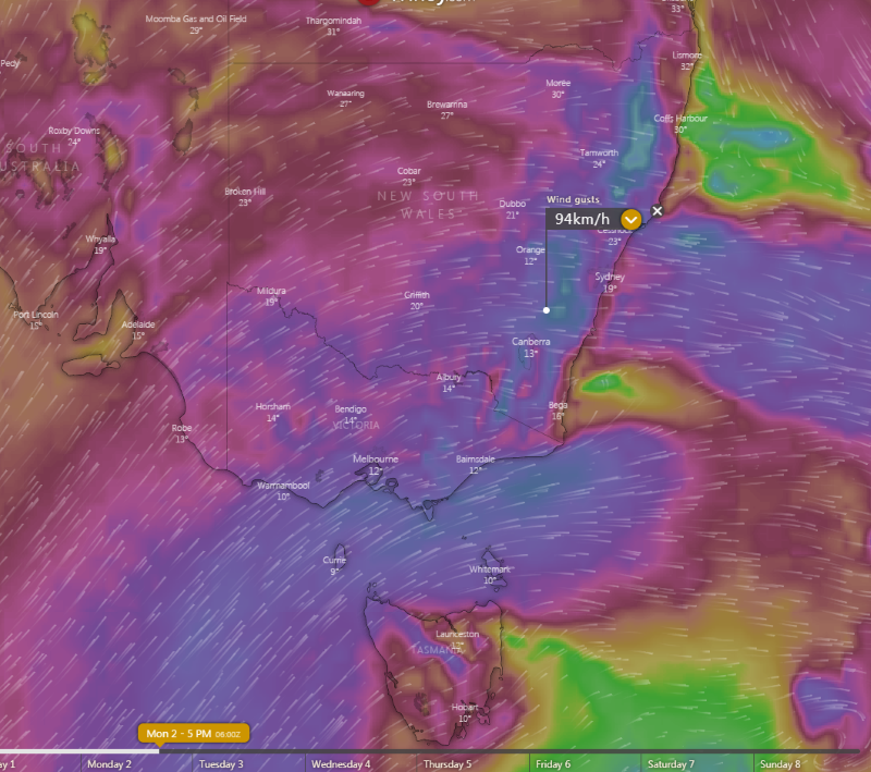
Image 4: Wind gust forecast for Monday 2nd December, 2019 Windy.com
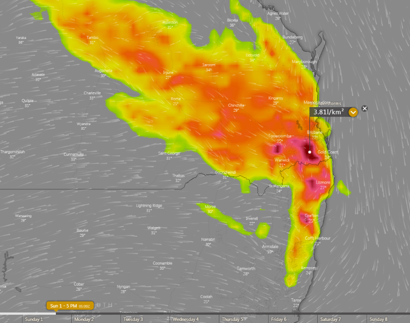
Image 5: Thunderstorm forecast for northeast NSW/southeast QLD on Sunday 2 December, 2019. Windy.com
A wild mix of weather is set to affect Australia to kick off summer, as the southeast of the nation is lashed by cold, wet and windy weather and alpine snow, whilst the east sees severe thunderstorms and more dangerous fire conditions.
A strongly negative Southern Annular Mode, which is likely still being caused by the Sudden Stratospheric Warming event over Antarctica in late August, is causing cold fronts to be stronger and extend further north than usual for this time of the year.
Whilst a weak cold front will cause showers and thunderstorms and cooler conditions over Tasmania, Victoria and NSW over the next two days, the strongest of these fronts is likely to impact the southeast of the nation on Sunday and into Monday.
Temperatures are expected to plunge as much as 10 to 15 degrees below average for December in some areas of southern NSW, VIC and TAS, with Melbourne expected to experience one of its coldest starts to summer on record, reaching just 17 degrees on Sunday and 16 degrees on Monday.
However, much of the day will feel cooler, with showers and isolated thunderstorms (which may be associated with small hail) and strong winds adding an extra chill factor to the air and temperature oscillations. Over the eastern ranges of Victoria, extending up to the NSW central tablelands, widespread falls of 5 to 15mm are likely, with some heavier falls up to 20-to-30mm possible.
The airmass is expected to be cold enough to produce snow over the alpine areas, with as much as 15-30cm of fresh snow likely. Areas in Tasmania above 500-600m are also expected to receive some snowfalls.
However, over the nation's east, particularly over northeast NSW and into QLD, this front is expected to lead to severe thunderstorms on Sunday, and dangerous fire weather on Monday.
Strong and dry westerly winds, gusting to 80-90km/h in some areas, will extend far further north than normal into these areas on Monday and combine with temperatures in the mid-to-high 30s to lead to extreme fire weather.
This is terrible news for these fire ravaged areas, with the winds likely to cause large ongoing fires, such as the Bora Ridge fire in northeast NSW, and Cunningham Gaps and Mt Barney fires in southeast QLD to flare up, with the risk of new blazes as well.
Similar conditions will persist into Tuesday, although some easing will occur as a high pressure region approaches.
Image 1: High resolution ACCESS C 1hr precipitation field. WeatherWatch Metcentre
Image 2: Storm potential, Friday 5pm. Windy.com
Image 3: Storm potential, Saturday 5pm. Windy.com
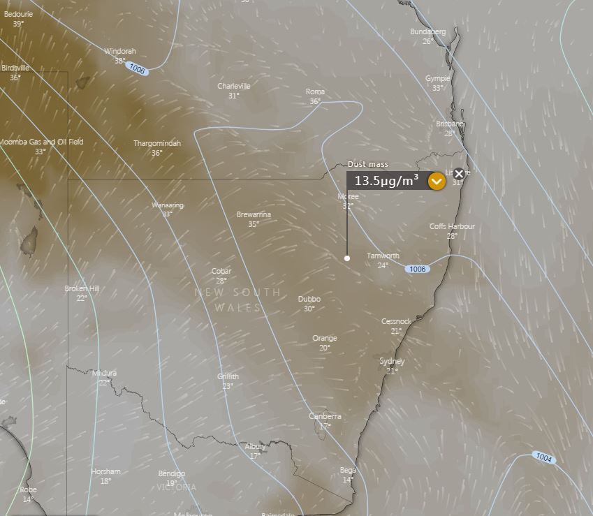
Image 4: Dust mass for NSW, Saturday everning. Windy.com
Scattered thunderstorm activity is expected to return to eastern NSW on Friday afternoon, particularly across the Northern Tablelands, Mid North Coast and North West Slopes and Plains.
A surface trough situated across inland NSW, separates a dry airmass to the west and a moist and unstable airmass across the eastern half of the state. A tongue of stronger wind shear from an approaching upper trough should enter the region late tomorrow afternoon.
This wind shear, in combination with a relatively moist and unstable airmass, will help one or two storms to be become organised during the afternoon and produce damaging winds and large hail, particularly across regions in the Northern Tablelands and northern Mid North Coast.
During Saturday, a strong cold front and associated trough will shift east through the state, with the potential for a large line of thunderstorms to develop during the day. This line is expected to rapidly move east, with the potential to produce damaging winds with its passage
Areas of raised dust are once again likely to move across the state, with a strong and gusty westerly flow in the wake of this front.
Image 1: EWN satellite and lightning tracker
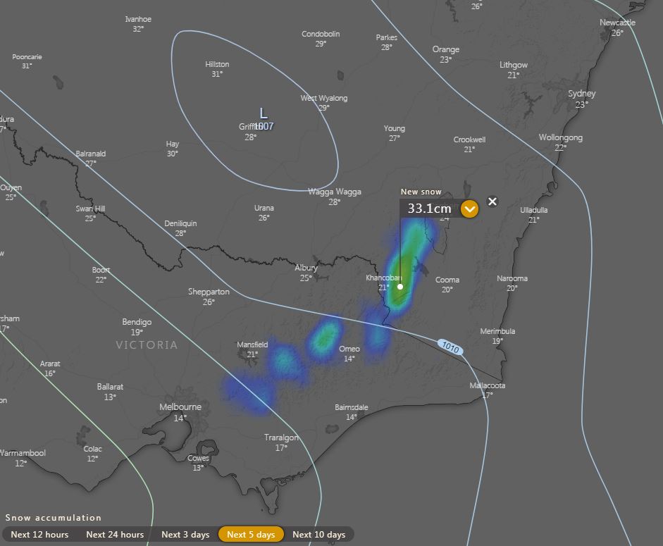
Image 2: Next 5 days snow accumulation. Windy.com
A surface trough and cold front that swept across eastern Australia during Tuesday producing an astonishing mix of weather across the eastern states.
Across central and northern NSW, a line of severe thunderstorms moved across the region with Fort Denison recording a wind gust to 104km/h.
Other significant recorded gusts were:
Across the Sydney basin, thunderstorms rapidly intensified on approach to the CBD, producing downed trees and powerlines which causing havoc for afternoon commuters. The northern suburbs of Sydney were the hardest hit, including those of Gordon, Chatswood, Asquith and Narrabeen, with some suburbs also reporting small hail for the second day in a row.
large dust storms whipped up by strong outflow winds in association with severe thunderstorms raced east across northern NSW, reducing visibility to meters during the late afternoon. Cloud to ground lightning strikes were responsible for nearly 100 new fires over the last 24hrs, with 151 fires now burning across the state.
Whilst dust, smoke and fires have been normality for central and northern NSW over the last few months, Victoria and Alpine regions of NSW seemingly have winter on repeat. 5-10cm of snow fell across Alpine regions on Tuesday, with further flurries possible during the remainder of the week for areas above 1600m. Medium range model guidance suggests the potential for further snow to develop next week across these regions, with another 5-15cm possible, particularly on Monday as the strongest front moves through.
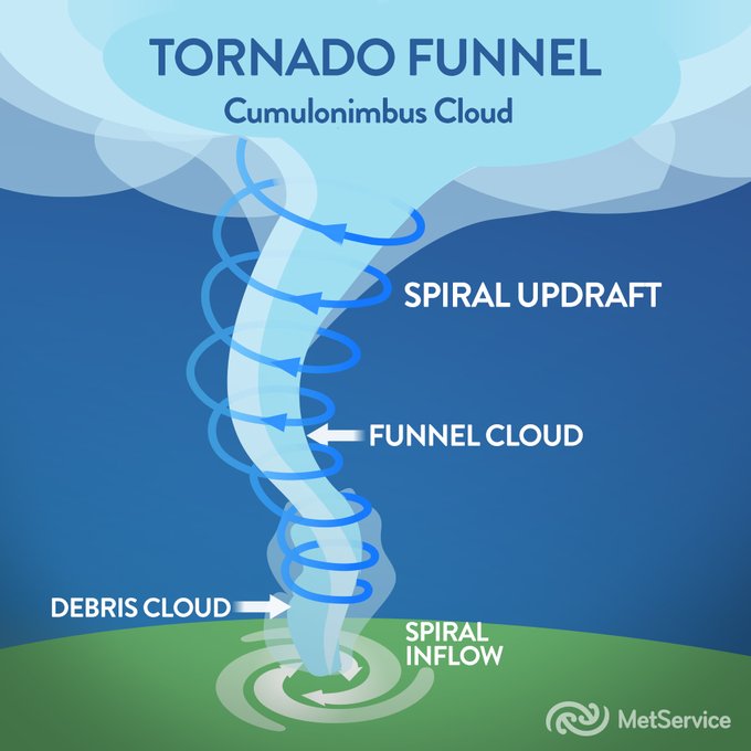
Image: Anatomy of a tornado funnel via the NZ Met Service.
Severe thunderstorms including one that produced a tornado in Christchurch last Monday, resulting in minor damage and injuring two people in Sydenham. At 12:39pm, the Met Service NZ issued a Severe Thunderstorm Warning for the elements of Very Heavy Rain, Large hail and possible Tornadoes last Monday the 18th of November, 2019 for the Selwyn and Ashburton local government areas.
Multiple large, dangerous and damaging fire have occurred and are still ongoing. Residents away from the battlefield would be well accustomed to the daily smoke intake for households across the region.Severe thunderstorms were tracking to the east-northeast and were expected to lie near Rakaia and Chertsey at 1:07pm with the Met Service updating the warning to include Selwyn, Waimakariri and Christchurch City at 1:12pm. Half-an-hour later the tornado touched down near Sydenham in the city of Christchurch from approximately about 1.45pm to 2:00pm accompanied by strong wind gusts, large hail stones and very heavy rainfall.
The official Met Service NZ weather station at Christchurch Airport (located approx. 14km away from the suburb of Sydenham), received a peak wind gust reading of 57km/h around the same time as the tornado occurrence, however unfortunately this was quite an inaccurate representation of the true wind speeds from near the centre of the thunderstorm complex at the time. The FENZ (Fire and Emergency Service NZ) southern communications centre received about twenty-five weather-related callouts between the period of 2:00pm and 3:00pm as the thunderstorm affected and cleared out of the Christchurch area.
After the front moved offshore, eyewitness accounts of waterspouts were reported about the bay areas off to the northeast of the city of Christchurch. By 4:20pm, the Met Service NZ confirmed the tornado occurrence, partly due to visual confirmation from images submitted via twitter and video from various other social media sources from the community.
According to the NZ Met Service, the November 18th, 2019 Christchurch tornado only reached EF0 on the Enhanced Fujita Scale, a global scale used to measure the intensity of tornado. The ?EF scale? ranks tornados from zero to five based on the wind gusts and the level of destruction it is expected to deliver. EF0 was the weakest on the scale with gusts of 104km/h to 136km/h estimated, and five the strongest with gust over 321km/h.
Generally, tornadoes for New Zealand form, but not always, associated with prefrontal squalls, bands of thunderstorms and/or isolated supercell thunderstorms. On average about seven to ten moderate to strong tornado events occur annually and usually track only for a couple of kilometres over a short duration of time. Tornadoes can blow out windows, lift roofs, break large branches off trees, generate dangerous flying debris and blow vehicles off the road and this why it is imperative to listen and follow all warnings and alerts issued via the Met Service NZ relating to any severe weather threats.
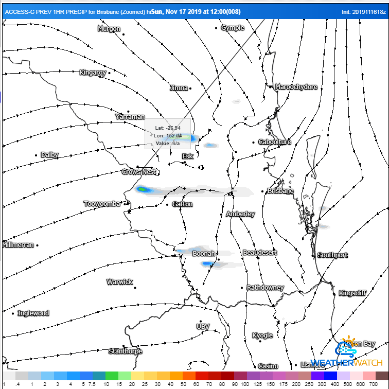
Image 1: ACCESS C 1hr precipitation field 12pm. WeatherWatch
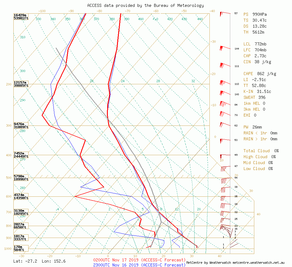
Image 2: ACCESS C Esk Sounding 1pm EST WeatherWatch
It was evident during the morning that an impressive kinematic and thermodynamic profile existed across SE QLD with bulk shear profiles in the 40-45kts range & ML CAPE (Convective Available Potential Energy) across coastal regions was in the order of 2000-3000 joules, with a strong north-easterly feed developing during the afternoon hours. A strong short wave trough would enter SE QLD with a relative vorticity max sitting across the region. This vorticity max would produce a region of PVA (Positive Vorticity Advection) which would contribute to upper level divergence in the PVA, thus rising air. Of note, the axis of this short wave trough was also perpendicular to the surface trough across SE QLD. 18Z ACCESS C soundings showed surface to 2km lapse rates at impressive values, sitting around the 9.5C/km (dry adiabatic is 9.8C/km), and the 0-6km lapse rate around 7.0C/km across SE QLD during the afternoon hours (see images below).
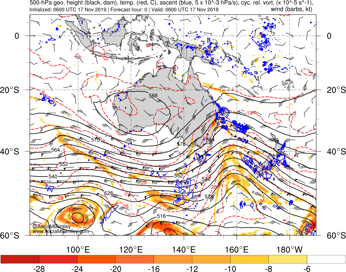
Image 3: Images via Alicia M Bentley
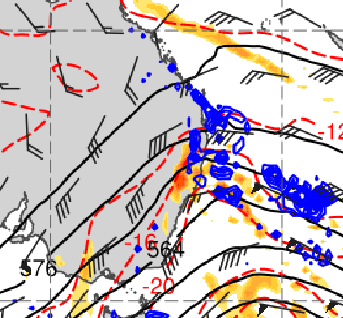
Image 4: Images via Alicia M Bentley
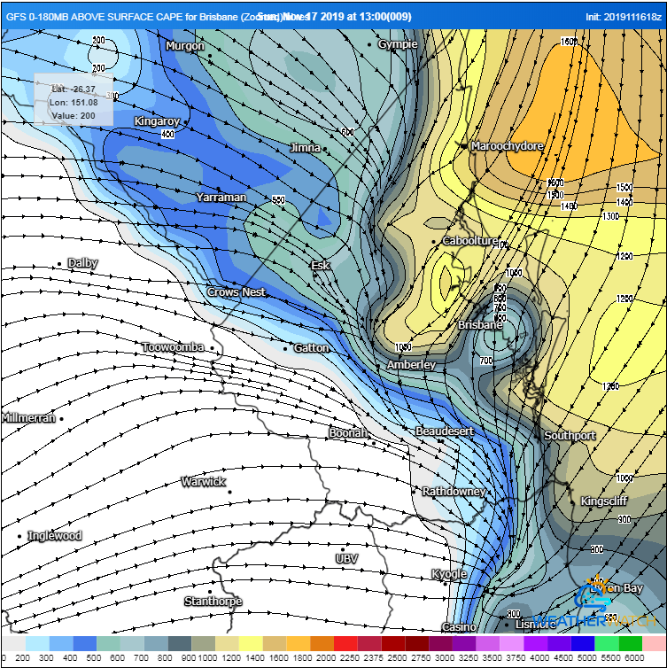
Image 5: GFS Surface streamlines and CAPE
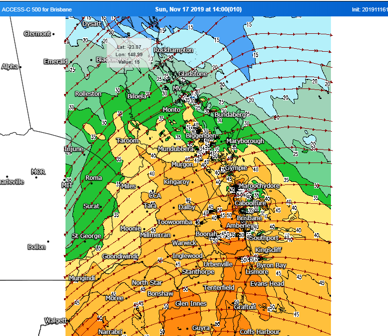
Image 6: 500MB, WeatherWatch MetCentre
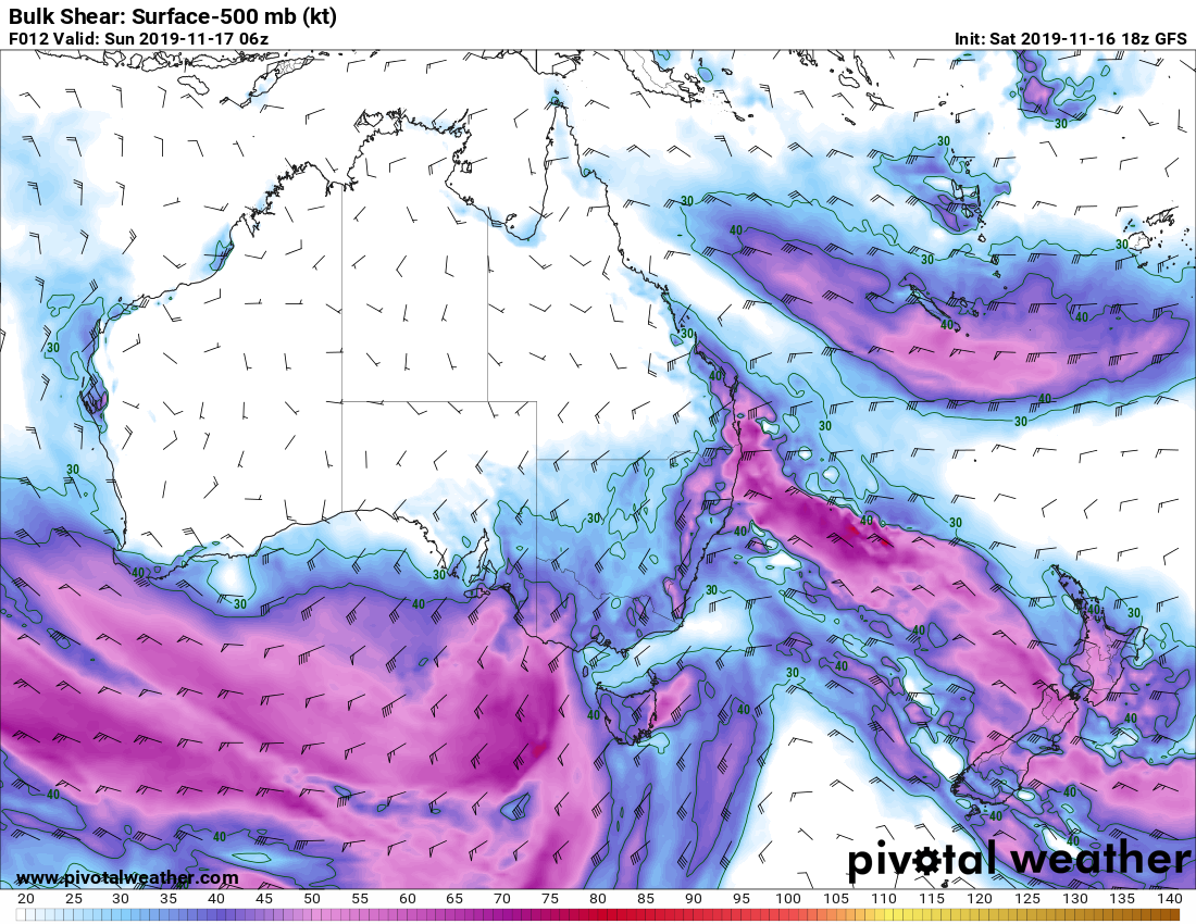
Image 7: Bulk Shear, Pivotal Weather
18z GFS analysis also showed that drier westerly winds would push very close to the SE Coast from Brisbane to the NSW border, inhibiting the amount of convection that might develop across this region, however forecast soundings via ACCESS C were still very impressive and showcased the potential for supercells should activity fire in this corridor. One potential issue was CIN (Convective Inhabition or a cap) across coastal regions. However, the lift from the shortwave aided in breaching this cap, enabling storm activity to tap into the quality moisture and instability across coastal locations, enabling thunderstorms to rapidly intensify and become supercellular.
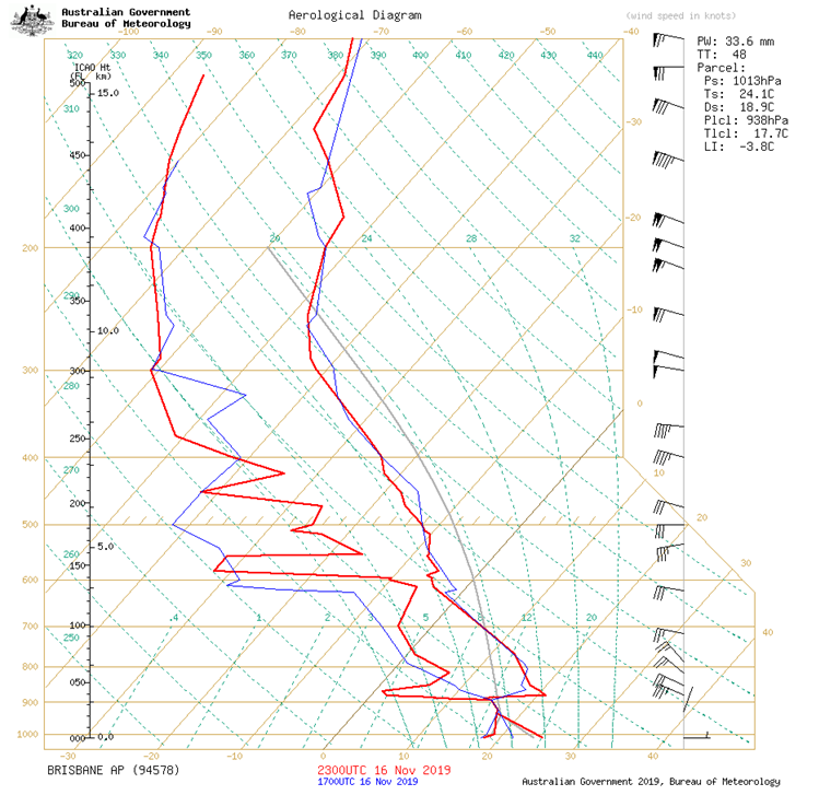
Image 8: Brisbane sounding, Sunday morning BoM
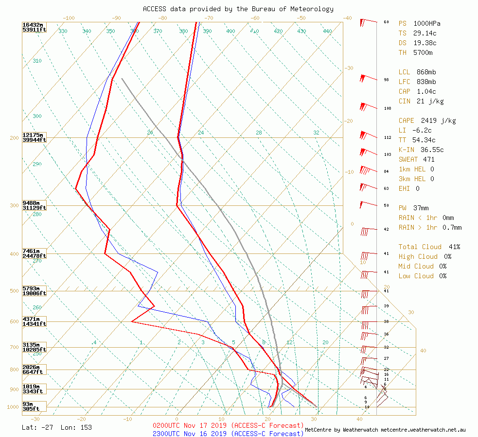
Image 9: ACCESS C sounding, Sunday afternoon (Brisbane to Sunshine Coast). WeatherWatch
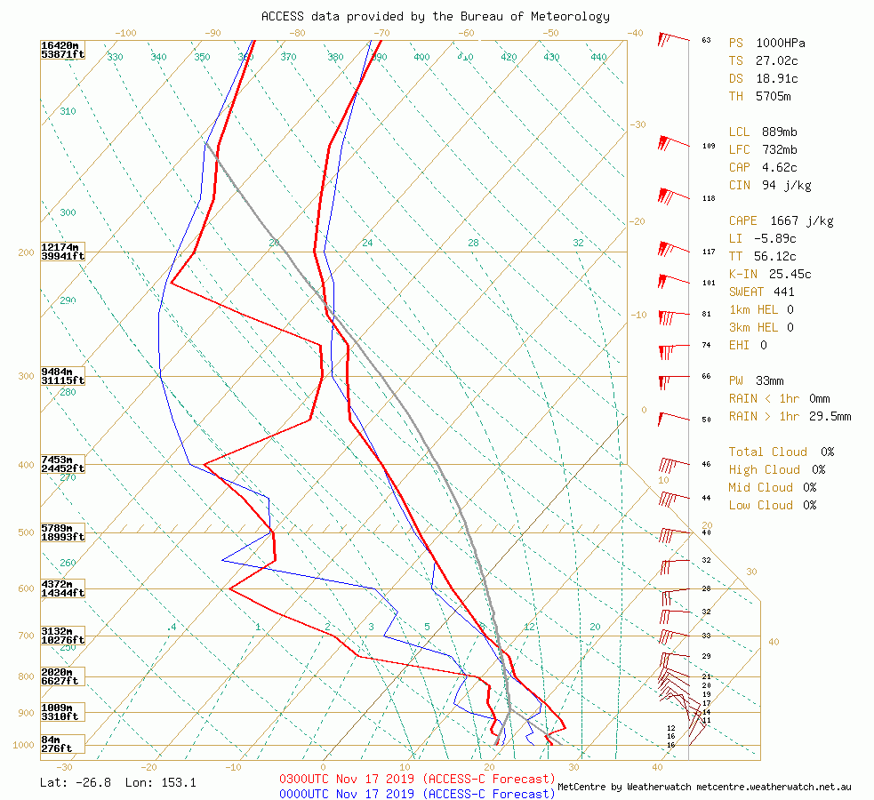
Image 10: Sunshine Coast sounding. WeatherWatch
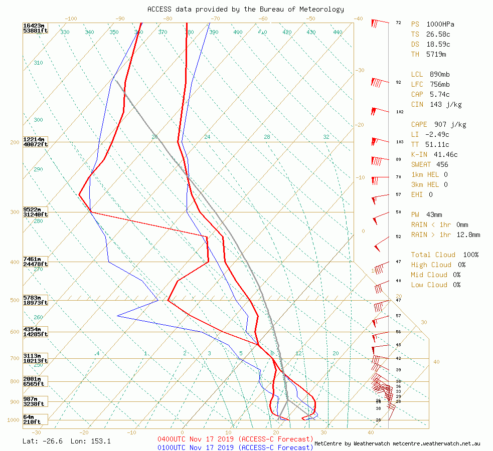
Image 11: Sunshine Coast sounding. WeatherWatch WeatherWatch
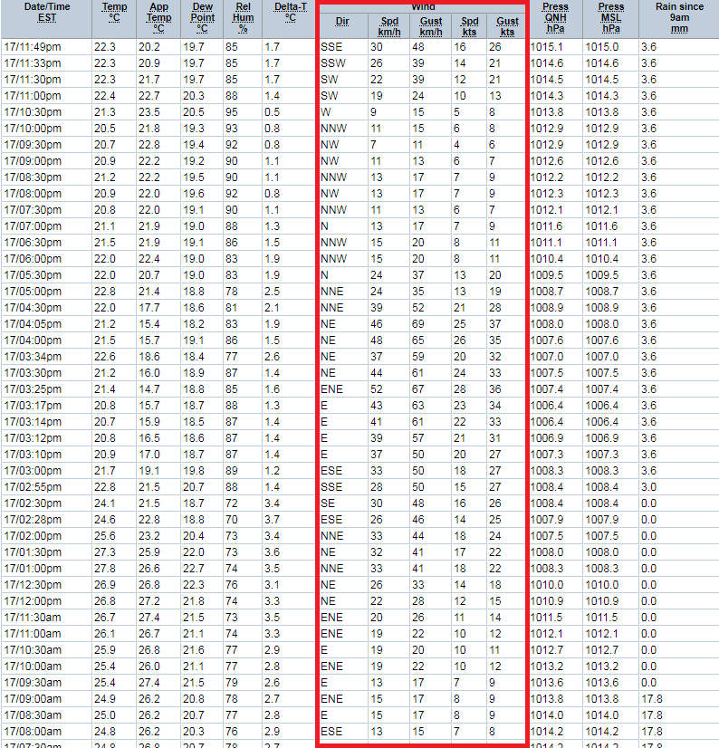
Image 12: Sunshine Coast AP observation, Sunday 17/11/2019h
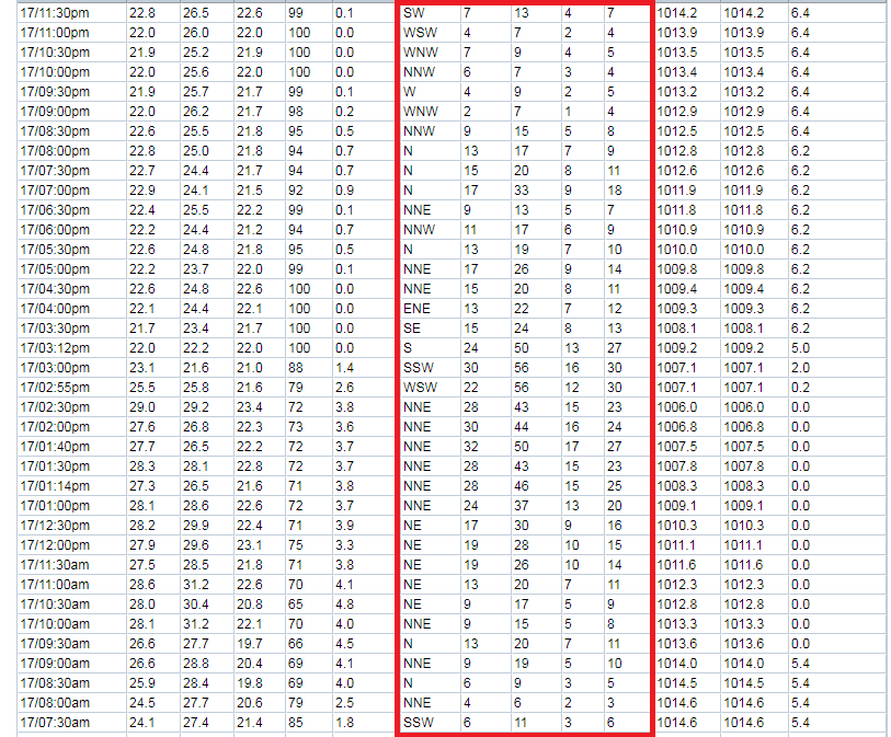
Image 13: Tewantin Observation, Sunday 17/11/2019
As the storm across the Sunshine Coast began to intensify, it took on classic supercell characteristics. A large hook echo began to form along with a well defined V notch on radar, the sign of an extremely strong and powerful updraft. It was very evident on 3d radar that this storm was impressive, showing a very clear and well defined BWER (Bounded Weak Echo Region). Very strong inflow was now feeding this supercell, with north to north-easterly winds gusting to 70km/h as seen on the observation images above. A clear and well defined couplet was now evident on radar. It was evident that this storm was capable of destructive winds and giant hail. With such a powerful storm exhibiting these characteristics, tornaodgenesis couldn't be ruled out, however it would only be a slim possibilty considering a marginal LLJ (850mb winds) was present. No considerable damage consistent with tornadic activity was reported/occurred.
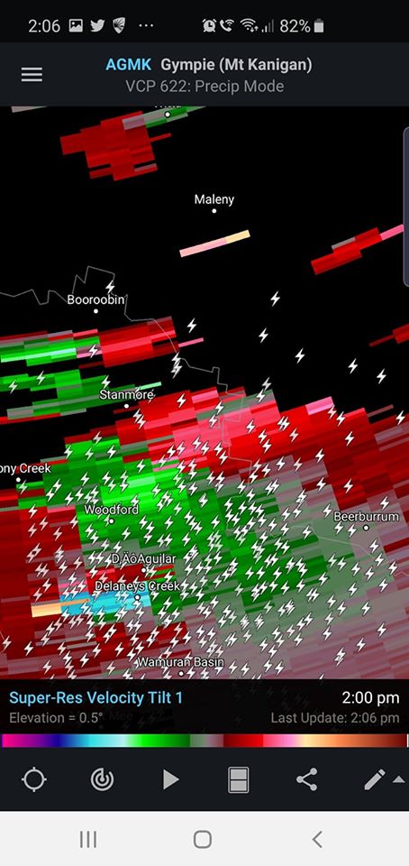
Image 14: Images via Radar Scope showing inbound and outbound winds, along with a well-defined hook echo
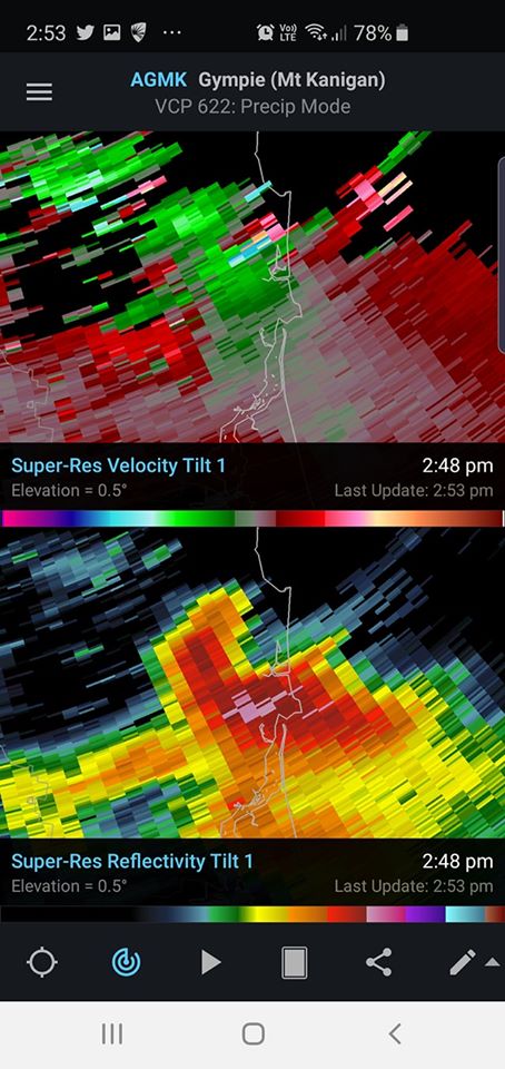
Image 15: Images via Radar Scope showing inbound and outbound winds, along with a well-defined hook echo

Image 16: Hail to cricket ball size over the Sunshine Coast region
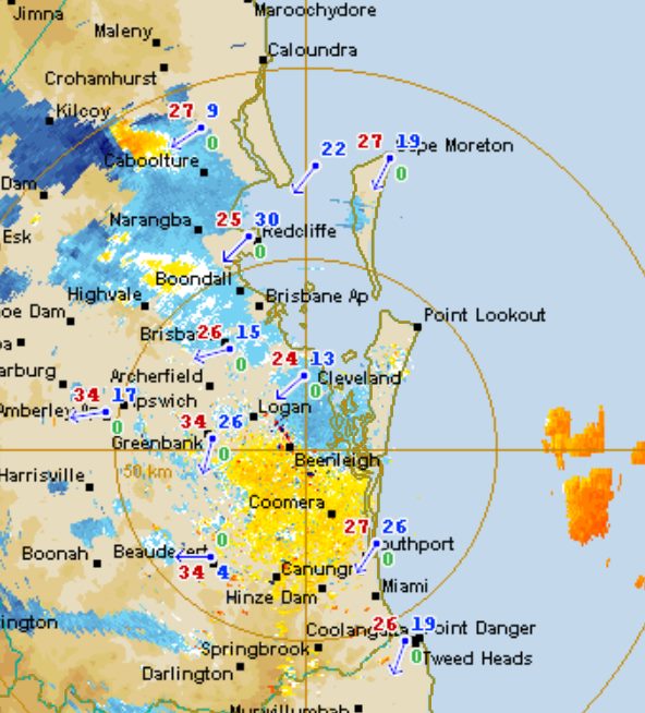
Image 17: A strong couplet begins to develop NW of Caboolture
Image 18: Strong inbound and outbound winds near Woodford
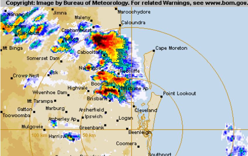
Image 19: A classic V notch appearance takes shape on radar
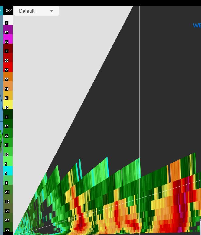
Image 20: Classic BWER signature on 3D radar
Across the Logan Village-Tamborine-Ormeau-northern Gold Coast regions, splitting supercells developed, with a particularly impressive right moving supercell producing hail between golf ball and cricket ball size. The sounding below was taken from the Tamborine area via ACCESS C. WE can see that this profile exihibits large cape, good shear, moisture depth to nearly 800mb along with streep lapse rates from the surface to 900mb, 800-600mb, along with a pronounced dry slot in the mid levels. Right moving supercells in SE QLD tend to be of the LP (Low precipitation) mode and usually produce large hail. Given the impressive set-up, it was easy to see why a thunderstorm in this environment would rapidly intensify and produce large hail.
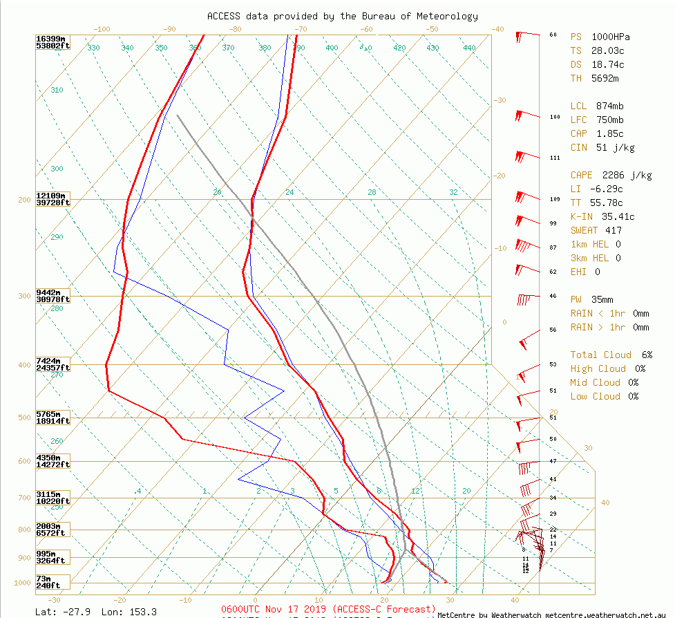
Image 21: Sounding from the Tamborine region, Sunday afternoon 17/11/2019
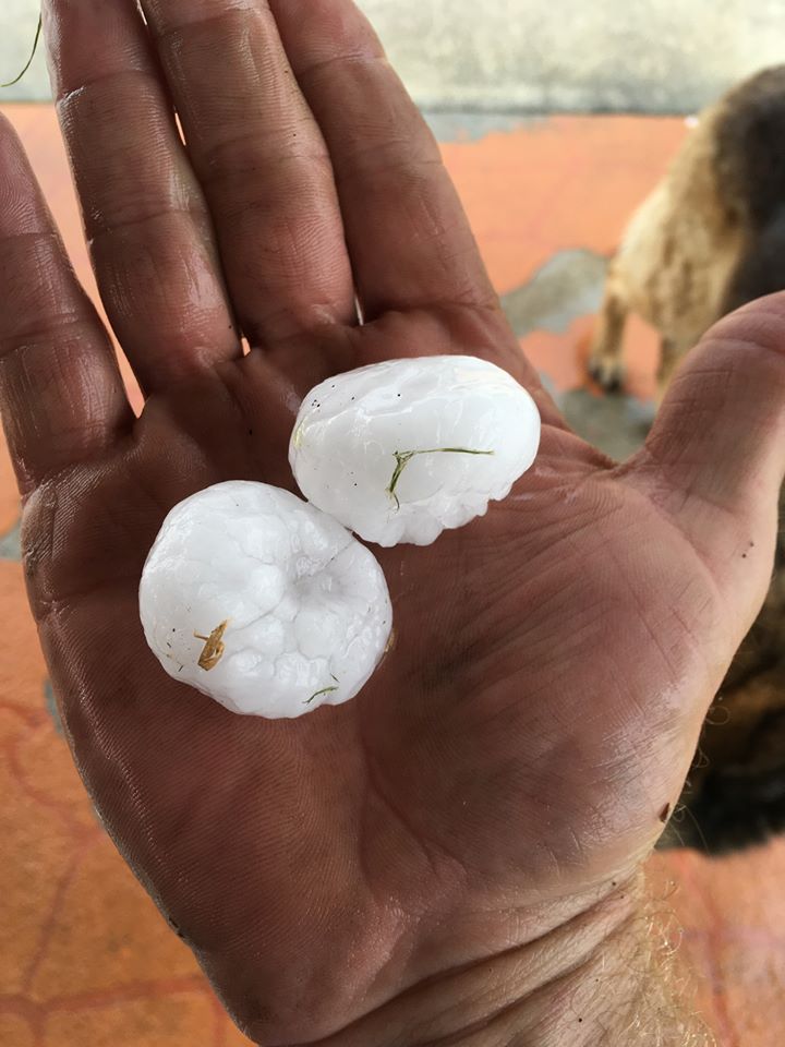
Image 22: Golf ball sized hail from Tamborine
On Sunday 17th November 2019, a significant thunderstorm outbreak occurred across South East QLD. Unofficial hail to the size of softballs (10cm diameter) were reported across parts of the Sunshine Coast, with hail larger than golf balls reported across parts of Logan and the northern Gold Coast.
So, let's have a look back at this day, and how it all unfolded.
Firstly, this day should have come as no shock to people, as thunderstorms, including the potential for severe thunderstorms were forecast days in advance by numerous agencies.
A surface trough was draped from the Gulf all way down into northern NSW, taking on a more north to south orientation across SE QLD and NE NSW (this orientation will be important later on). One big uncertainty on this day, would be whether drier west to south-westerly winds may push too close to the coast. Regardless of this, it was evident that thunderstorms were more than likely at least across the Sunshine Coast region.
The morning started off sunny with temperatures quickly warming up. The 18z analysis showed a nice tongue of 700-800mb moisture from the southern Wide Bay through to north of Brisbane. This was likely to be the trigger for more elevated/high based convection during the early afternoon hours across parts of the Brisbane Valley. 18z ACCESS C 1hr precipitation was on the money for this event across this region, blowing up activity at around lunchtime.
Here is a video recap of the last two weeks. During this period, The Early Warning Network has issued more than 300 alerts across NSW & QLD. This video highlights how wind changes affect these fires daily, and how this smoke can affect locations well away from the fire danger zone.
During November, catastrophic to severe fire dangers have been a daily occurrence across northern NSW.
Multiple large, dangerous and damaging fire have occurred and are still ongoing. Residents away from the battlefield would be well accustomed to the daily smoke intake for households across the region.
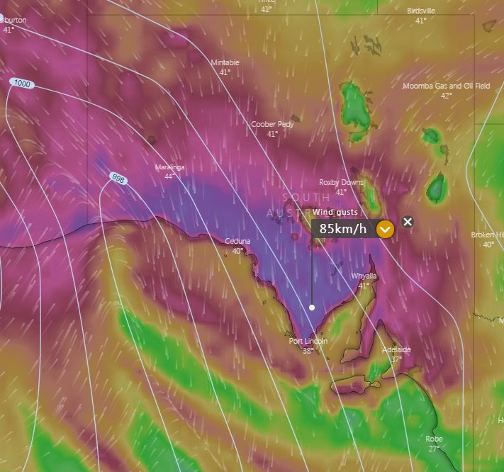
Image 1: Windy gusts, Wednesday afternoon. Windy.com
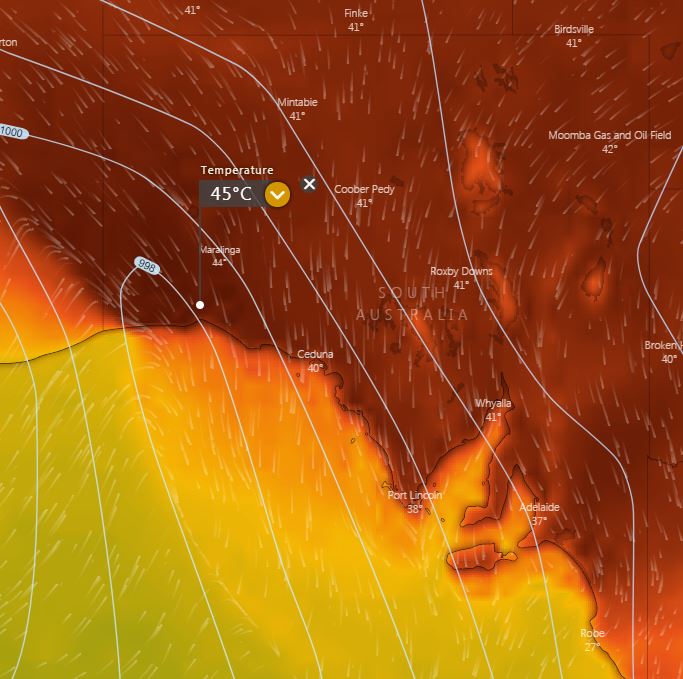
Image 2: SA max tempertures Wednesday afternoon. Windy.com
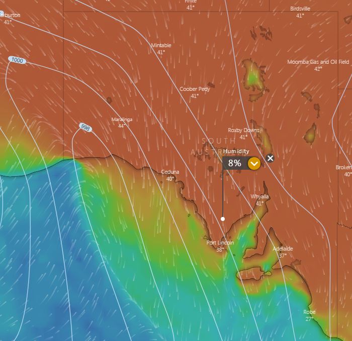
Image 3: SA humidity Wednesday afternoon. Windy.com
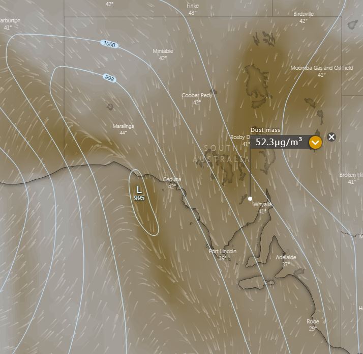
Image 4: Dust mass for SA, Wednesday afternoon. Windy.com
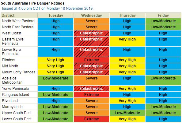
Image 5: SA fire danger for Wednesday. BoM
A potentially significant fire day is expected for South Australia during Wednesday, with catastrophic fire conditions forecast for the West Coast, Eastern Eyre Peninsula, Lower Eyre Peninsula, Mid North, Mount Lofty Ranges and Yorke Peninsula.
A cold front and prefrontal trough will shift east during Wednesday, with increasing north to north-westerly winds dragging an extremely hot and dry airmass across South Australia.
Potentially record heat is expected to build during the day, with Adelaide forecast to hit 42C, with the current November record of 43C set back in 2009 under threat. Numerous locations across the state will see temperatures soar into the 40's, with mid to potentially high 40's at some locations. These temperatures will be nearly 20C above the November average.
Strong to locally damaging winds are expected to develop across western parts of the state, before shifting east throughout the day. Sustained winds of 40-50km/h, with gusts to 90km/h expected, which may lead to downed trees and powerlines.
This intense heat coupled with strong winds and humidity below 10% is expected to lead to rapidly spreading bushfires during the afternoon and evening. Cooler conditions will move in the from the west, with gusty south-westerly winds expected in the wake of the front. This may complicate conditions for fire fighters, with fires potentially spreading on multiple fronts.
Dusts storms are also expected during Wednesday, particularly across central locations of the state fanned by strong north-westerly winds.
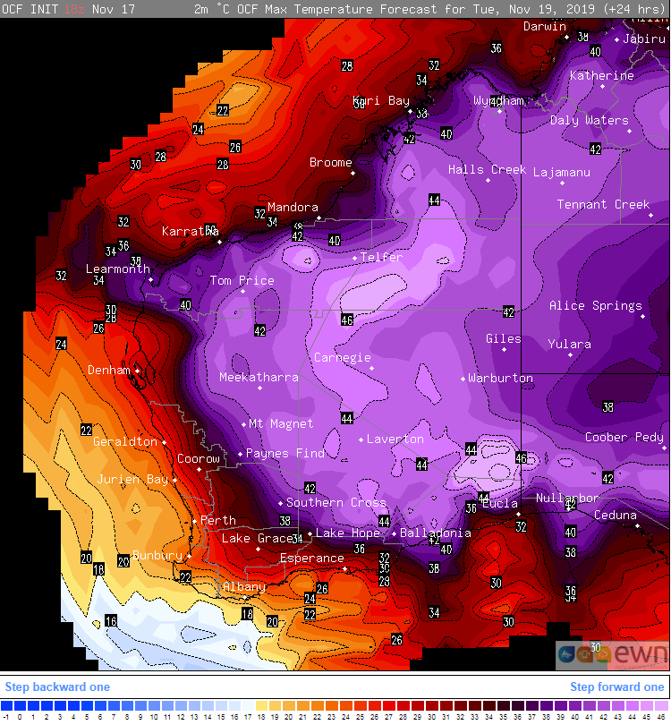
Image 1: OCF Forecast temperatures across Western Australia on Monday 18 November, 2019
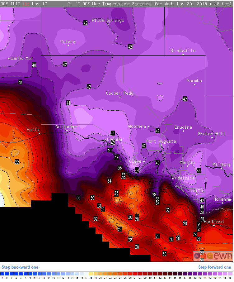
Image 2: OCF Forecast temperatures across South Australia on Wednesday 20 November, 2019
November records were smashed across the weekend as an extremely hot airmass impacted Western Australia, with places such as Perth and Kalgoorlie registering their hottest November day on record.
Very hot conditions have been scorching the state over the past few days, with Perth registering its first four day spell over 35 degrees in November since 1933. On Saturday, a new November record was set as the city reached 40.4 degrees and the airport 41.1 degrees, eclipsing the previous record in 2003.
Other notable records (>40 years of records) to fall on Saturday included Wongan Hills (43.2 degrees) and Mullewa (43.5 degrees).
On Sunday, this heat shifted east across the state, breaking a record that has stood for more than 100 years at Kellerberrin, where it reached 44 degrees. Other notable records included 43.5 degrees at Merredin, 43.4 degrees at Meekatharra, 44.7 degrees at Kalgoorlie (including a record 26 degrees overnight) and 45 degrees at Salmon Gums.
Very hot conditions will persist over the next two days over the state (except the southwest), with temperatures reaching into the low-to-mid 40s, before a cold front flushes the heat out by Wednesday.
This will focus the hottest airmass over South Australia on Wednesday, with Adelaide forecast to break its hottest November day on record with a maximum temperature of 43 degrees. Strong dry and gusty northerly winds have also lead to early forecasts for catatrophic fire danger for the Lower Eyre Peninsula, York Peninsula, Mid North and Mount Lofty Ranges, with Severe to Extreme Fire Danger for the remainder of the state.
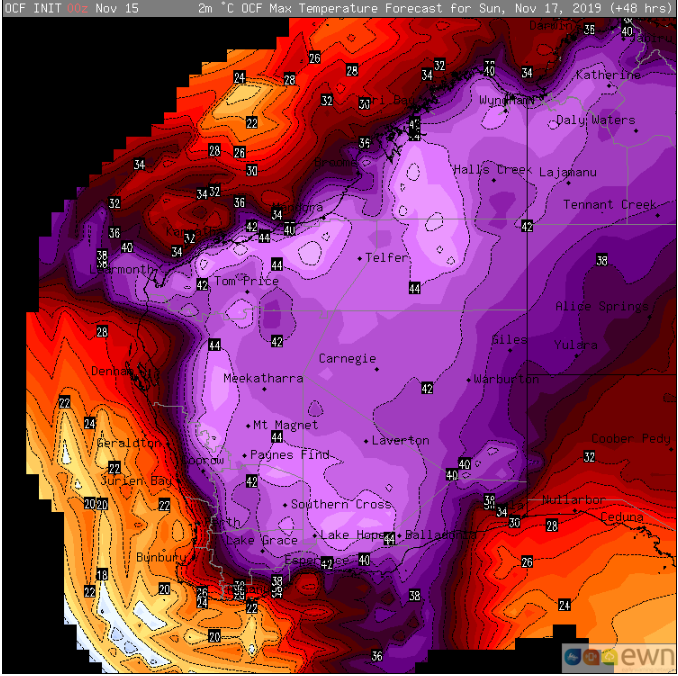
Image 1: OCF Forecast temperatures across Western Australia on Sunday 17 November, 2019
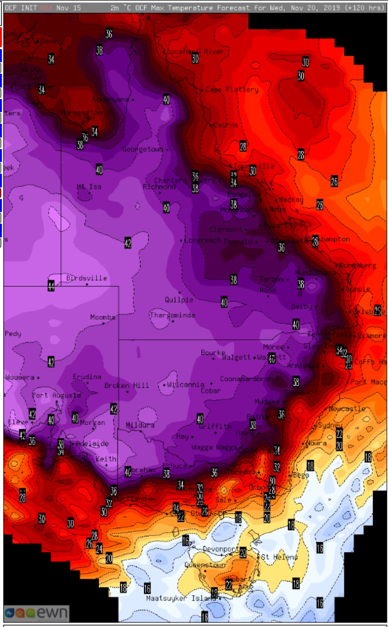
Image 2: OCF Forecast temperatures across Eastern Australia on Wednesday 20 November, 2019
An incredibly hot airmass for November is building over Western Australia, which is likely to see records tumble over the weekend and early next week as temperatures soar into the mid 40s.
A slow-moving heat trough is currently residing over WA and has been producing temperatures reaching into the mid-to-high 30s the last few days, with Perth experiencing its third consecutive day above 35 degrees.
Tomorrow, the heat will begin to clear the west coast, although Perth may reach 35 degrees, which would make it four consecutive days above 35 degrees, which hasn't occurred in November since 1933. However, the airmass will intensify even further over the weekend, with Kalgoorlie forecast to reach 44-45 degrees on Sunday, which would smash its previous record of 42.7 degrees.
Ravensthorpe is also forecast to reach 42 degrees on Sunday, which would challenge its current record of 42.1 degrees, whilst other towns, including Norseman, Meekatharra, Southern Cross, Leonora and Lake Grace are all expected to reach new November records.
The bad news is this heat is expected to begin sweeping east from Tuesday due to a cold front, which is also expected to be associated with strong winds which will cause dangerous fire weather.
While a while away, there are indications Adelaide could challenge its November record on Wednesday with potential for it to reach into the low-to-mid 40s. Inland parts of SA, NSW and much of Victoria are also expected to experience very hot conditions on Wednesday where records may be challenged.
Current indications suggest that while the airmass will remain hot, it will break down somewhat over fire affected regions as the system encounters some moisture. This may lead to the development of showers and thunderstorms, although it is too early to tell if these will contain much rain.
A strongly positive Indian Ocean Dipole (IOD) - whereby waters over the Indian Ocean are cool in the east (near Australia) and warm in the west, has been a significant culprit in the unusually hot airmass (and in the nation's drought in general). When in a positive phase of the IOD, moisture over the nation's west is much lower, resulting in minimal cloud cover and allowing heat to build without interference. Any cold front or trough can then pick this heat up and drag it across the country.
The positive IOD is expected to break down into summer along with the onset of the monsoon, with long term forecasts hinting at a return to near average rainfall and cloudiness from January.
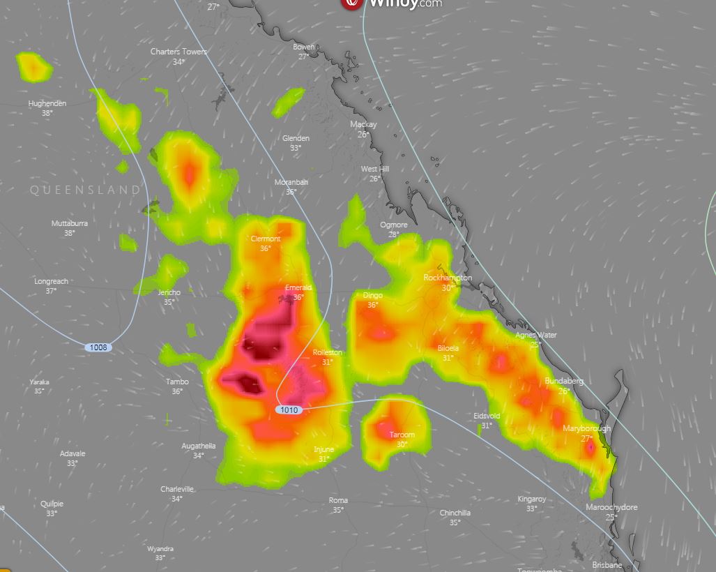
Image 1: Potential thunderstorms, 4pm Friday afternoon. Windy.com
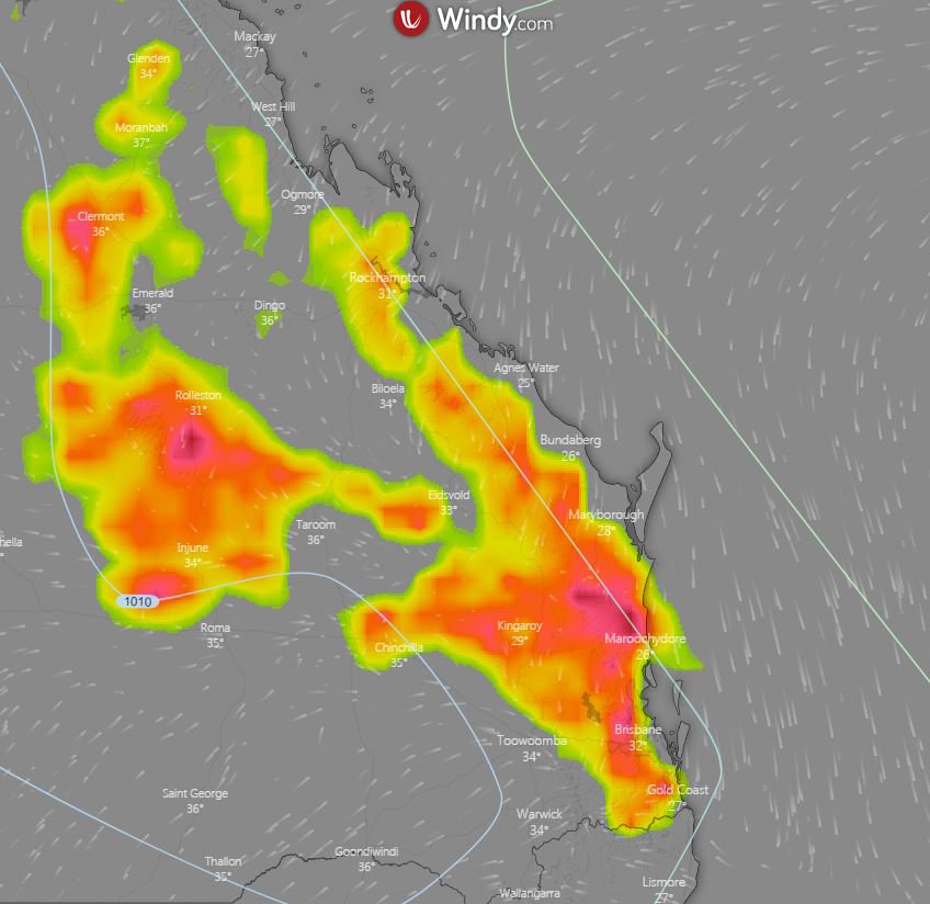
Image 2: Potential thunderstorms, 4pm Saturday afternoon. Windy.com
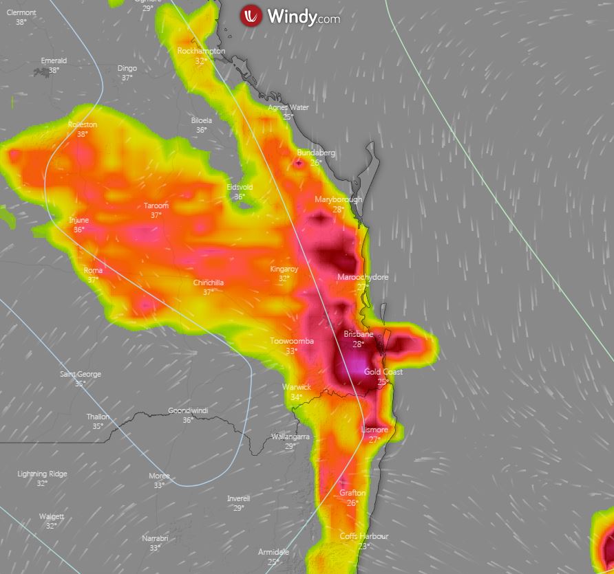
Image 3: Potential thunderstorms, 4pm Sunday afternoon. Windy.com
Thunderstorm activity is expected to return to central Queensland this afternoon, with a gradual increase in activity across eastern districts over the next few days.
A surface trough extending from the Gulf region to the South East inland, is separating a very dry airmass to the west and a moist, unstable environment to its east.
To the east of this surface trough, isolated showers and thunderstorms are expected to develop late this afternoon across inland parts of the Capricornia and Central Highlands districts. Activity isn't expected to reach coastal locations where a strong cap (or lid preventing convection) is present.
During Friday, onshore winds will push the trough a little further inland for northern parts of the Central Highlands, and in combination with an approaching upper trough, will help generate widespread instability. This is expected to lead to an increase in activity during the late afternoon and evening hours. Due to dry air in the lower levels of the lower atmosphere, storm activity across this region will be conducive to producing locally damaging winds in the form of microbursts.
Similar conditions will continue during Saturday afternoon, with storm activity dipping slightly further south towards northern Brisbane, Sunshine Coast and Wide Bay and Burnett region. Severe storm activity is considered low for SE QLD on Saturday, but damaging winds and the threat of hail, may develop across the southern Wide Bay region.
At this stage, Sunday is shaping up as the most impressive thunderstorm day, with scattered to widespread activity anticipated. Whilst rainfall totals will generally remain light, there will be the potential for a couple of storms to become severe with damaging winds and large hail. Due to such dry conditions, cloud to ground lightning may provide another ignition point for bushfires across an already ravaged region.
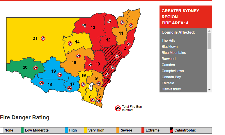
Image 1: Fire Danger ratings for NSW for Tuesday 12 November, 2019 (Source: Rural Fire Service)
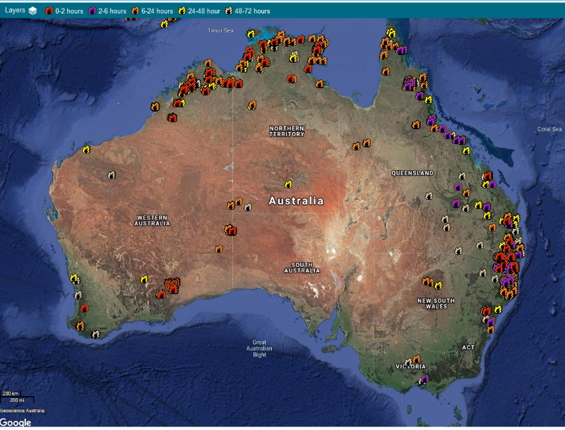
Image 2: Sentinel hotspot data for fires across Australia (Source: Senintel.ga.gov.au)
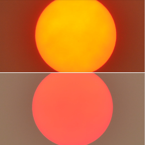
Image 3: Smoke thickening up in the evening over northeast NSW, significantly blocking out the sun
Widespread and devastating fires have hit parts of NSW and QLD across the past week, with dangerous bushfire conditions over the next few days likely to worsen the situation further.
Record dry conditions across the past few years have combined with unseasonably strong cold fronts (which has brought with them strong, dry and gusty winds) to cause dangerous bushfire weather.
Whilst there have been a number of large fires across the states in September and October, between Thursday and Saturday last week (and especially Friday) produced some of the most devastating fires the state has ever seen, with many of these blazes still raging.
On Friday, there was a record 17 emergency warned fires across NSW, with more than 100 fires still burning across NSW and QLD. As of today, 970,000 hecatares have been burnt over NSW, almost as much as the last three fire seasons combined, with this figure certain to rise further.
At least 150 homes have been destroyed in NSW and three lives lost, with a further eight homes destroyed at the bushfire affecting the Yeppoon region. Huge amounts of wildlife has been lost, including more than 350 koalas near Port Macquarie.
Even those areas that aren't burning, but are to the fires east are suffering due to very poor air quality, with smoke reaching as far as New Zealand and New Caledonia.
Tomorrow, another cold front which will be associated with strong and dry winds is expected to cause dangerous fire conditions across NSW again. Catastrophic fire danger is forecast for the Illawarra, Greater Sydney and Greater Hunter, with Severe to Extreme fire danger forecast for large areas of the remainder of the state. This will cause dangerous flare ups of previous fires, with new fires likely to start, and spread into areas that have not been affected by blazes so far.
Strike teams have been organised by the NSW Rural Fire Service, with crews being called in from the Country Fire Authority (CFA) from Victoria to help with any outbreaks.
The current fire situation is considered unprecedented, with the fires leading to more loss and burning a larger area than the 2001-2002 and 1994 bushfires, with no widespread heavy rainfall in sight.
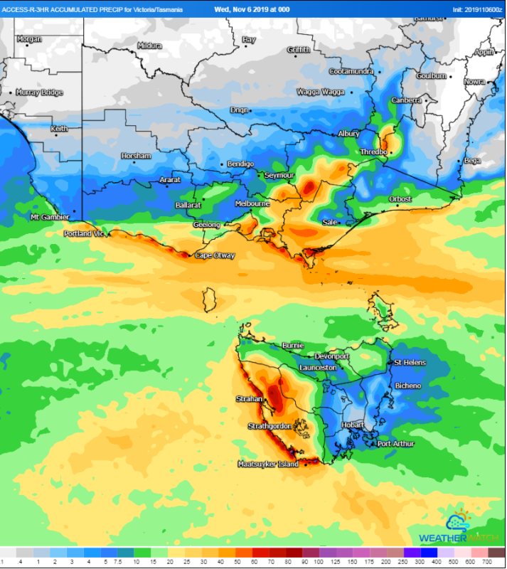
Image 1: Accumulated rainfall to 11am EDT Saturday 9 November, 2019 for southeast Australia (Source: Weatherwatch MetCentre)
<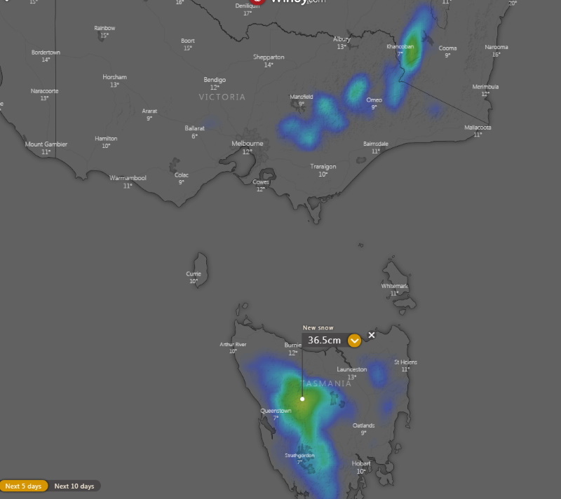
Image 2: Accumulated snowfalls over the next 5 days (Source: Windy)
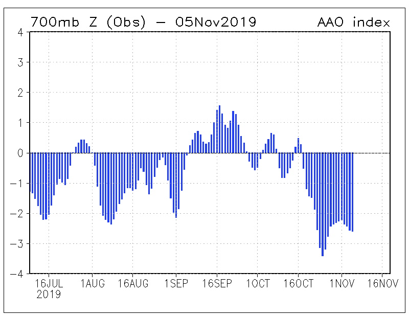
Image 3: South Annular Mode Readings over the past few months (Source: Bureau of Meteorology)
A late spring blast of cold, wintery weather is affecting southeastern Australia from today and into the weekend, with some of the coldest November conditions in more than a decade possible for the region.
A deep low passing south of Tasmania will send a series of strong cold fronts over the region during the next several days, with the pattern more typical of mid-winter rather than November.
Strong winds, showers, thunderstorms and small hail are likely over the next few days across Tasmania, Victoria and southeastern South Australia, possibly affecting southern New South Wales on one or two days. However, strong winds ahead of the front may push as far north as Queensland later this week, bringing with it raised dust and potential for bushfires.
A particularly cold airmass is likely to cross on Friday and into Saturday, bringing potential for snow as low as 500 metres in Tasmania, and as low as 800 metres over VIC and southern NSW with potential for flurries as far north on the highest parts of NSW Central Tablelands.
Melbourne is forecast to reach just 14 degrees on Friday, its coldest November day since 2007, and just 15 degrees on Saturday. Hobart is also forecast to reach just 14 degrees on Friday.
The fronts are likely to lead to good rain totals across some areas, with up to 100mm possible over the next several days over western TAS and parts of eastern Victoria, with isolated higher totals not out of the question.
A strongly negative Southern Annular Mode is responsible for the vigorous frontal activity, shifting westerly winds much further north than usual for this time of the year. This is believed to be linked to the Sudden Stratospheric Warming event that occurred over Antartica during late-winter.
Conditions will begin to warm up again from Sunday due to a region of high pressure.
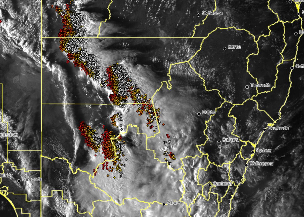
Image 1: 24 hour rainfall totals to 9am 4 November, 2019 over NSW
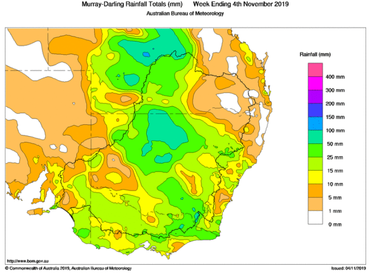
Image 2: Weekly rainfall totals to 4 November, 2019 across the Murray Darling Basin
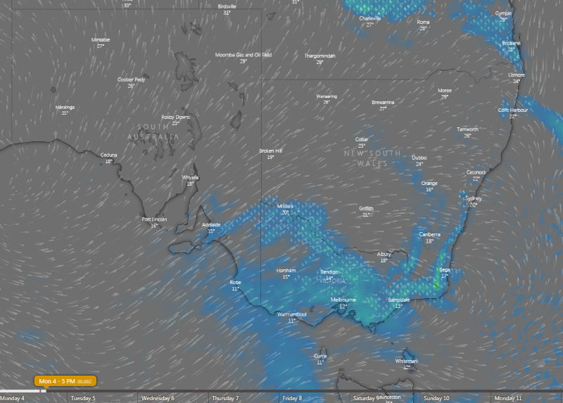
Image 3: Thunderstorm forecast for this afternoon across southeastern Australia (Source: Windy)
Heavy rain and gusty thunderstorms soaked parts of New South Wales yesterday, with some places seeing their best rain in more than half a decade over the state's west.
Record dry has been gripping many parts of NSW this year, with bushfires raging across many parts of the state, particularly the east.
Due to lower vegetation loads, the west hasn't had quite as many bushfires, however dust storms have been common occurences as cold fronts, lacking any sort of rain, but send strong winds across the region, whipping up dust.
A brief absence of cold fronts allowed onshore winds sourced from the Pacific Ocean and Coral Sea to send moisture inland, and link up with a trough to generate widespead rain across the state. Widespread totals of 15-to-25mm fell, with isolated higher totals in excess of 50mm under heavier thunderstorms.
Some of the heaviest rain fell across the state's west, with Bourke recording 66mm in the 24 hours to 9am today (on top of 28mm the previous day), the heaviest rain since January 2012. Wagga Wagga collected 55mm over the past two days, making it the heaviest two day total since early December 2017.
Other notable totals in the 24 hours to 9am included 50mm at Brewon (west of Walgett), 42mm at Okeh, 41mm at Killala and 38mm at Thredbo. The great news was that pretty much everywhere in the state has had some sort of rain over the past two days, except the northeast.
Unfortunately, over the fire ravaged Port Macquarie and Forster areas, only a few millimetres were recorded.
The focus of the rain will shift into far northeast NSW and southern QLD today, whilst southern and central-east parts of the state may see showers and potentially severe thunderstorms this afternoon and evening near a cold front.
Unfortunately, no follow-up rain is likely, as this front and a series of fronts mid-to-late this week will push out all the moisture, and bring a return to the conditions we've become accustomed to recently.
High temperatures, strong winds, dust storms and bushfires are again likely, whilst alpine areas and parts of Tasmania could see unusually heavy snow falls for this late in the year.
![]()
Image 1: EWN Satellite and lightning tracker, Saturday afternoon.
After months of monotonous weather across parched regions of Australia, the heavens finally opened for inland regions of NSW, VIC and southwestern QLD.
A cold front and associated surface trough moving across southern-inland Australia interacted with increasing moisture to its east, generating cloudy conditions, scattered showers, severe storms and rain periods during Saturday afternoon.
Northwestern parts of NSW received the highest rainfall totals to 9am this morning, with Gumbooka just northeast of Bourke scoring a wonderful 49mm. Meanwhile Bourke registered 28mm, Knightsvale 26mm, Delta 38mm and Wanaaring 27mm
Whilst not as heavy, central and southwestern parts of NSW also scored some handy falls, with Cobar registering 20mm, Noona 23mm, Broken Hill 16mm Griffith AP 11mm and West Wyalong AP 19mm.
Moderate falls were also recorded in VIC, where a severe weather warning remains for heavy rainfall that may lead to flash flooding across northeastern parts or the state this afternoon. Up to 9am this morning, the heaviest totals were Mt Buller with 38mm, Snowy Range 29mm, Poley Range 32mm.
Impressive dust storms were recorded across western NSW during Saturday afternoon, as severe thunderstorms whipped up damaging outflow winds to 100km/h, pushing a wall of dust east. Photo of dust storm over Lake Cargelligo
Throughout Sunday, showers, rain periods and thunderstorms are continuing, and are expected to increase in coverage during the afternoon hours. Severe storm activity is expected again, with damaging winds and heavy rainfall that may lead to flash flooding being the primary risks.
Image 1: Himawari 8 VIS True Colour 07:10 - Saturday, 2nd November 2019.
Some magnificent morning glory roll clouds were evident on satellite early this morning for parts of the Gulf of Carpentaria and Burketown, QLD. Morning glory clouds often occur during the months of September and October when cooler ocean temperatures intersect with warmer temperatures over the landmass.
Before the wet season commences, the weather trend begins to alternate back and forth between wet season and dry season patterns, with cycles of three to four days of dry season southeasterly trade winds followed by a few days of seabreezes associated with heat troughs. These patterns signal the onset of the ?morning glory season? as there is always a seabreeze with high humidity levels the day before the arrival of the phenomena.
One of the best locations to observe the morning glory is Burketown, QLD during these months. The morning glory cloud traditionally wisps through Karumba, QLD prior to dawn and arrives shortly after first light through the Burketown area. This roll clouds then tend to dissipate over the landmass where less low-level moisture is available. In some instances, cloud bands can reach up to 1,000km in length, 1 to 2 kilometres in width, 200m above the surface and travel of speeds up to 60km/h.
Glider pilots specifically target these events for gliding. What makes hang-gliding the so incredible is the lifting air rising up over the advancing cloud, offering pilots the chance to soar without constantly seeking thermal lift, much like water pushes a surfer up the face of the wave. The pilots harness this wind energy to glide in front this incredible natural occurrence.
Morning glory clouds also bring cultural significance in that Gangalidda people believe the morning glory was created by Walalu, the Rainbow Serpent. Secondly, the Gangalidda believe the phenomena is also a source of energy. People involved in traditional aboriginal law and ceremony can tap into that energy. The cloud formation is also celebrated as part of Burketown's annual Morning Glory Festival at the end of September.
On Sunday 17th November 2019, a significant thunderstorm outbreak occurred across South East QLD....
A surface trough and cold front that swept across eastern Australia during Tuesday producing an...
It has been a severe weather period to forget for many across the eastern seaboard, as numerous...