Weather News 2020 November
Image 1: Operational Consensus Forecast max air temperature for Saturday 28/11/2020. Image via...
A series of fronts are helping drag down a very hot air mass sourced from the nation's west, with temperatures set to challenge records for today during the day and into the next couple of evenings. A State of Emergency has now been declared for the ACT and is in effect to protect the community from worsening fire and weather conditions. In a State of Emergency, it is imperative that everyone is prepared, even if you are not in the area of immediate danger. As a community, the ACT must all be prepared ahead of more extreme weather conditions that are forecast for the ACT and the surrounding region.
Significantly elevated fire danger is present for the majority of Victoria today with severe ratings current for the Mallee, Wimmera, Northern Country, North Central, South West and Central districts with Extreme fire danger present for the Midlands region of Tasmania. Significant severe fire dangers are also current for the eastern and southeastern portions of Tasmania, including the East Coast, Upper Derwent Valley, South East and Central Plateau under in the influence of severe fire danger. Conditions are expected to abate back to High to Very High dangers for tomorrow.
Looking ahead into tomorrow, the hottest air mass will contract to eastern Victoria and southern and central New South Wales. Very hot temperatures are anticipated with the OCF Forecast Consensus predicting temperatures of 44° for Kapooka, 43° for Cowra, Dubbo, and Wagga Wagga, 42° at Nowra and Parkes respectively. Daytime maximum temperatures may also reach or exceed 41° for the Canberra Airport with 37° forecast for Cooma.
These very hot temperatures combined with dry and windy conditions are expected to elevate fire danger to severe thresholds for people situated within the Illawarra/Shoalhaven, Far South Coast, Monaro Alpine and Southern Ranges. Very warm overnight temperatures will also remain this evening, and overnight into Saturday for southeastern parts of the continent, with some areas unlikely to fall below 30° as a minimum. Winds will ease slightly for Victoria during tomorrow, however may still be fresh and gusty at times with the worst fire conditions likely over for parts of northeastern Victoria.
Conditions are expected to ease further for Victoria late on Saturday and into Sunday at this stage with much cooler conditions over southeastern parts. Another cold front on Sunday and into Monday may be cold enough to bring snow to Tasmania, and in addition will bring a significant cooling of conditions across southeast Australia and respite from the hot conditions this past week.
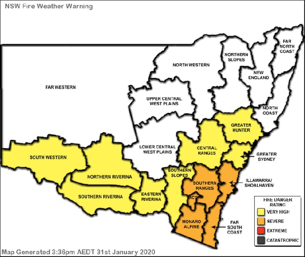
Image 1: New South Wales Fire Weather Warning for Saturday, 1st February, 2020
%20OCF%20Maximum%20Daytime%20Temperature%20forecast.gif?width=600&height=545&name=MetCenter%20(Weatherwatch)%20OCF%20Maximum%20Daytime%20Temperature%20forecast.gif)
Image 2: MetCenter (WeatherWatch) OCF Maximum Daytime Temperature forecast for
Friday, Saturday, Sunday and Monday as at Friday, 31st January, 2020
Over the next few days, South Australia is likely to see its heaviest and most widespread rain event for nearly 4 years, dating back to the major September 2016 event.
Tropical moisture will be dragged south into a cold front moving across SA today and Friday, with widespread showers, storms and rain periods likely.
Over the next three days, widespread totals of 30-80mm are expected, with isolated falls of up to and exceeding 100mm possible, particularly with storm activity.
This rain event will begin across northern SA today, before steadily spreading south into central and eastern SA on Friday and Saturday.
Whilst temperatures are climbing in the 40's across central and southern parts of the state, overcast conditions and rainfall will drop maximum temperatures in the coming days, especially during Saturday where temperatures are likely to remain in the low to mid 20's across central and south-eastern SA.
At 11:26am local time, a flood watch was issued by the Bureau of Meteorology from the Central Northern though to South East parts of SA, making this the first flood watch issued for the state since August 2018.
Conditions are expected to gradually ease during Sunday, as a south-westerly flow develops in the wake of the cold front, with a few isolated coastal showers persisting.
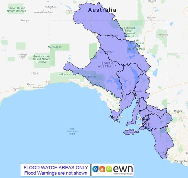
Image 1: EWN flood watch map for South Australia
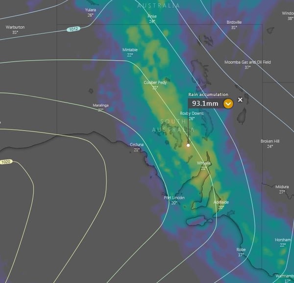
Image 2: EC accumulated precipitation next 3 days
After a run of cooler weather, an intense burst of heat will sweep across southeast Australia between Thursday and Saturday, causing temperatures to soar into the mid 40s and dangerous fire conditions.
A series of troughs and a tropical low are helping drag down a very hot airmass sourced from the nation's west, with temperatures set to challenge records for both day and nights.
South Australia will feel the hottest part of the airmass tomorrow, reaching into the low-to-mid 40s across most of the southern half of the state, with the northern part being coolest due to cloud and rain. Fire Danger is expected to reach severe levels across many areas as gusty northerly winds combine with the heat.
In Tasmania, strong northwesterly winds are also expected with the state seeing amongst the worst fire danger it has experienced so far this summer.
On Friday, the hottest part of the airmass will focus across Tasmania, Victoria and New South Wales. Hobart will reach 38 degrees, Melbourne the low-to-mid 40s, and Canberra around 41 degrees. The worst fire conditions will likely be over TAS, eastern SA and central and western VIC as fresh to strong and gusty northwesterly winds accompany the heat, with fire danger reaching Severe to Extreme.
On Saturday (first day of February), the hottest airmass will contract to eastern Victoria and NSW. Griffith will rise to 45 degrees, Canberra 42 degrees (challenging its February record of 42.2 degrees), and Bega the mid 40s. Overnight temperatures will also remain high on Friday night into Saturday, with some areas unlikely to fall below 30 degrees.
Winds will ease a little but still be fresh and gusty at times, with the worst fire conditions likely over over the fire ravaged northeast Victoria, inland parts of the NSW South Coast, Snowy Mountains, Southern Tablelands and ACT.
Meanwhile, at the same time, a band of rain and thunderstorms is likely to be affecting SA, western VIC and parts of TAS, bringing significant relief.
This moisture will continue to feed east, with the airmass intensity breaking down as it moves into northern NSW and QLD due to increased cloud and rain.
A cold front on Sunday and into Monday may be cold enough to bring alpine snow to Tasmania, and will bring a significant cooling of conditions across southeast Australia, which is expected to linger into mid February at this stage.
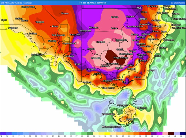
Image 1: OCF Forecast temperatures over southeast Australia on Friday 31 January, 2020 (Source: Weatherwatch Metcentre)
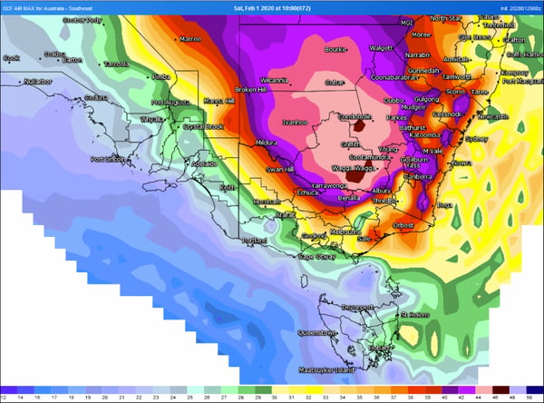
Image 2: OCF Forecast temperatures over southeast Australia on Saturday 1 February, 2020 (Source: Weatherwatch Metcentre)
Substantial and significant rainfall has fallen through parts of the Herbert and Lower Burdekin over the past 24 hours to 9am this morning, January 28th, 2020.
Yesterday and overnight, the State Emergency Service received approximately 20 calls for help in the Townsville area alone in response to the extreme rainfall. The rainfall has resulted in significant flooding for some areas including Ayr, which remarkably coincides this week with the one year anniversary of the 2019 Townsville flood event.
Some of the 24 hour rainfall figures recorded to 9:00am this morning include;
Rita Island - 529mm, Ayr - 421mm, Groper Creek Alert - 418mm, Inkerman Bridge Alert - 403mm, Brandon Alerts - 386mm, Ayr DPI - 328mm and Alva Beach - 275mm
Rail freight services have been cancelled indefinitely until the line can be checked and repaired due to the flooding throughout the Hughenden region with inland train services unable to be aided or replaces by road transport. The floodwaters have also cut the Bruce Highway section between Home Hill and Ayr, which has been impassable for motorists and other transport.
Remember to never enter into flooded water, or rushing/flowing water at any time.
We are keeping a close eye on the tropical low pressure system that has moved into the Gulf of Carpentaria where the system is expected to provide further moderate to heavy rainfall through the eastern gulf coastline today, including places such as Normanton and Kowanyama, before heading further south inland into late this week.
As of 4:00pm, an Initial Flood Watch for Coastal and Adjacent Catchments between Mackay and Innisfail has been issued for minor flooding across the region overnight tonight and tomorrow. Catchments likely to be affected include the Johnstone River, Tully River, Murray River, Black River, Ross and Bohle Rivers, Haughton River, Belyando and Suttor Rivers to Burdekin Falls Dam, Burdekin River to Burdekin Falls Dam, Burdekin River downstream of Burdekin Falls Dam and the Don and Proserpine Rivers.
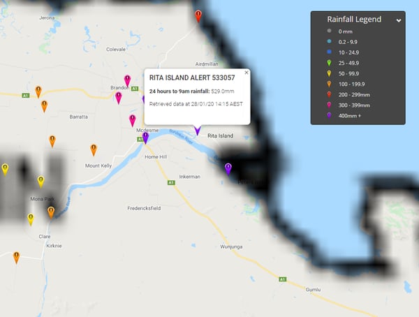
Image 1: 24 hour rainfall totals to 9am Tuesday, January 28th, 2020 for the Rita Island Alert indicating 529mm received.
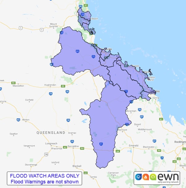
Image 2: Initial Flood Watch area as of 4:00pm, Tuesday, January 28th, 2020 for renewed rainfall for coastal and adjacent inland catchments between Innisfail and Mackay.
A slow moving surface and upper low is set to hover over the northern inland of the continent and cause widespread showers, storms and rain areas to persist day after day across much of the Northern Territory and northern Queensland.
When averaged across this area daily totals of 30 to 100 mm are likely to be common but some areas which experience storms could receive more than 100 mm in a day.
The wettest areas are expected to be in northeastern parts of the NT as well as far northwestern and the far north tropical coast and hinterlands of Queensland. These areas are likely to receive seven day accumulations up to 150 to 300 mm with locally heavier totals possibly much higher than that. This is likely to cause flash flooding as well as significant increases in river levels.
For now the low is expected to remain over land which reduces its risk of becoming a tropical cyclone but the chance of it coming close to Gulf of Carpentaria waters next week cannot be ruled out yet.
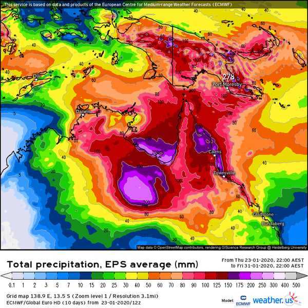
Image 1: Forecast ECMWF EPS seven day rain totals until Friday 31st January 2020 (Source: weather.us)
It was a testing Thursday for emergency services across New South Wales as fires, dust and strong winds battered the south of the state, whilst severe thunderstorms hit central and northern areas.
A strong cold front crossing the southeast generated strong northwesterly winds ahead of it gusting to 90-100km/h, pushing more dust over Victoria and NSW and felling trees and powerlines, leading to more power outages.
A very hot airmass also pushed ahead of the change, and combined with the strong winds caused dangerous fire conditions. This was particularly bad over southern NSW, where old blazes came back to life (and new ones started) and spread rapidly southeast. Homes were lost around Bermagui, Bodalla and Moruya, whilst three fire fighters were killed as an air tanker crashed around the Snowy Mountains.
Severe thunderstorms developed over the central coast and northern inland during the afternoon and evening, generating wind gusts to 100-110km/h, bringing down trees and powerlines, with reports of some houses being unroofed.
Thankfully some areas received some very good rain from the storms with narrabri recording 31mm to 9am, its heaviest fall in almost three years. Moree registered 49mm, on top of the 51mm recorded one week ago, making it the town's wettest month since March 2017.
This morning, a severe thunderstorm hit northwest Sydney, with reports of hail the size of golf balls around Castlereagh and Windsor. Severe thunderstorms have fired up again this afternoon across the state's north, with the threat of large hail, damaging winds and heavy rainfall.
The stormy pattern is expected to continue through the weekend.
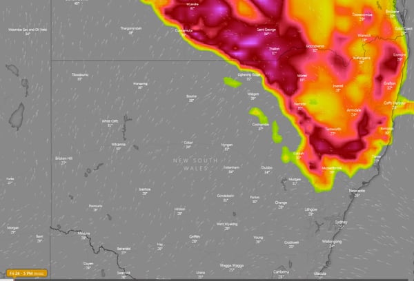
Image 1: Forecast ECMWF thunderstorm threat for Friday 24th January, 2020 (Source: Windy)
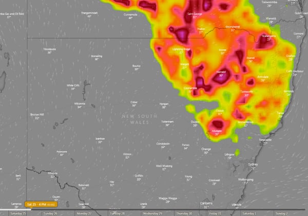
Image 2: Forecast ECMWF thunderstorm threat for Saturday 25th January, 2020 (Source: Windy)
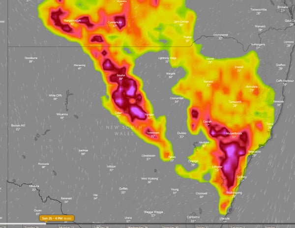
Image 3: Forecast ECMWF thunderstorm threat for Sunday 26th January, 2020 (Source: Windy)
A strong cold front is dragging a hot airmass and strong winds once again over southeastern Australia causing dust storms and fire danger to reach severe to extreme levels, however rain is thankfully on the way in the wake of the change.
The Southern Annular Mode (SAM) has moved back into a negative phase (a climate driver that sends westerly winds further north in this phase), pushing a strong frontal system across the region.
Severe Weather Warnings are current for Victoria, South Australia and New South Wales for wind gusts in excess of 90km/h, with potential for locally destructive gusts to 125km/h in showers and thunderstorms in SA.
A hot airmass is also being pushed ahead of the change is causing temperatures to push into the mid 30s to low 40s, although it is the strong winds causing the fire danger to increase most notably.
Fire danger is reaching severe levels over parts of SA, VIC and NSW today, with severe to locally extreme fire dangers expected over NSW tomorrow (the greatest risk being over central and southern areas). Several blazes have already broke out today across NSW, VIC and TAS.
The strong winds ahead of the front are also whipping up dust, with visibility down to 200 m reported between Peterborough and Yunta (SA)this afternoon. This dust storm is expected to move across TAS, VIC, NSW, SA and QLD this evening and into Thursday.
For VIC, TAS, southeast SA and far southern NSW, the fire threat will be greatly reduced in the wake of the change later today as a band of rain spreads across the area.
Flood watches for minor flooding are predicted across central and eastern parts of VIC due to falls of 20-to-40mm, and isolated totals up to 50-to-60mm. In TAS, widespread falls of 15-to-30mm are likely, with less in the east.
For NSW, wetter conditions will develop later Thursday and into Friday as showers and thunderstorms develop as a lingering trough is fed by moisture off the Tasmania and Coral Seas.
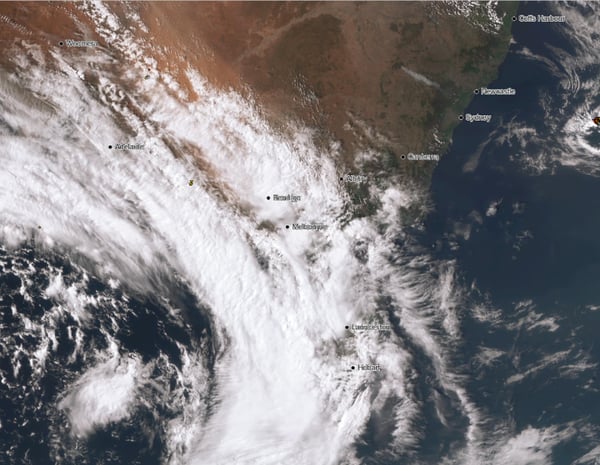
Image 1: Dust storm on visible satellite over southeast Australia on afternoon of Wednesday 22nd January, 2020
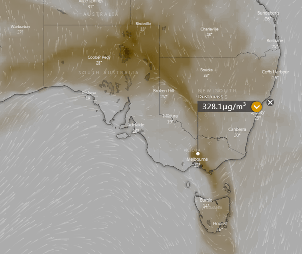
Image 2: Dust Mass Index for 2am over southeast Australia (Source: Windy.com)
Another round of severe thunderstorms occurred yesterday afternoon and evening for southeastern parts of Queensland and northern NSW leaving approximately 20,000 residents without power. Severe thunderstorms deroofed a home in Clifton on the Darling Downs, trapping a family due to live powerlines being downed.
The most outages were recorded through the inland Sunshine Coast later in the evening where 13,000 residents were power effected. 170,000 lightning strikes were recorded yesterday, which was more than double of the day before when 72,000 lightning strikes were recorded by Energy provider Energex.
A high-pressure ridge currently over the Coral Sea is driving in hot and moist tropical conditions across parts of the east coast, with a westward moving surface trough expecting to retreat slowly west during the next couple of days. This combined with moderate instability has resulted in very heavy rainfall associated with isolated thunderstorm activity.
Moderate to heavy rainfall up to 81mm was recorded at the Fairlies Knob alert in southern Wide Bay over 24 hours to 9:00am this morning, with 78mm received at Marodian, Mt Walsh on 63mm, Imbil 58mm and Yandina on 54mm respectively.
Further south into the Northern Rivers of NSW, more modest rainfall was received with isolated thunderstorm activity with 47mm of rainfall being received at Yelgun Creek over 24 hours to 9:00am this morning, 38mm at Mullumbimby, 28mm of rainfall at Huonbrook at 27mm at North Arm.
Later this afternoon, we are likely to see further isolated showers and thuderstorms through portions of the northeast and northwestern slopes of NSW where localised strong to damaging winds are the primary threats. Hot daytime temperatures are forecast tomorrow across the northern inland and central east portion of NSW where strong to gusty thunderstorms delivering damaging winds, large hail and heavy rainfall may be likely.
Conditions are expected to remain quite static today and into tomorrow with the slow westward drift of a surface trough through inland parts of central and southern QLD. This combined with hot daytime temperatures and favourable moisture will likely result in further strong to gusty isolated showers and thunderstorms tomorrow and into Friday where some may produce localised damaging winds, large hail and heavy rainfall.
Below are some images from both QLD and NSW from the Early Warning Network's very own Forecasters and Alert Operators:
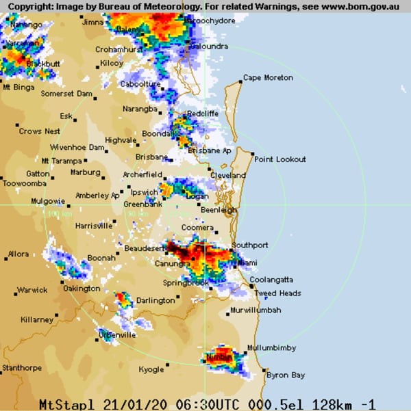
Image 1: Bureau of Meteorology Weather Radar - Stapylton as at 4:30pm QLD time
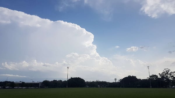
Image 2: Tuesday 21st January, 2020 Queensland view from Springwood facing to the south via Andy Barber.
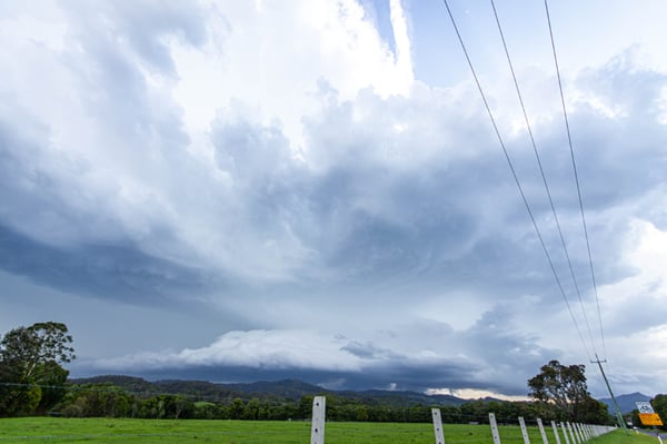
Image 3: Tuesday 21st January, 2020 New South Wales view from Burringbar via Justin Noonan.
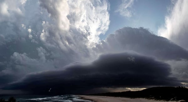
Image 4: Tuesday 21st January, 2020 New South Wales view from Hastings Point via Ben McBurney.
Showers and potentially severe thunderstorms are likely to develop today over far northeast NSW and eastern QLD, with potential for large hail, damaging wind gusts and very heavy rainfall leading to flash flooding.
Dangerous thunderstorms lashed parts of Victoria, New South Wales, the ACT and Queensland yesterday, with a notably destructive hailstorm hitting the nation's capital. Hail larger than the size of golf balls hit Canberra damaging many cars, whilst 65 glasshouses were damaged at the CSIRO, destroying years of research.
Whilst the setup isn't as volatile today, a significant amount of dry air in the mid and upper levels, high levels of convective available potential energy (CAPE) and sufficient wind shear is supportive of severe thunderstorms, particularly over northeast NSW and southeast QLD.
Large to giant hail is the main threat today, with the atmosphere capable of supporting hail up to golf and tennis ball size under stronger cells. With oppressive levels of humidity being felt currently over the region, very heavy rainfall and wet microbursts are also possible.
With dry air intruding from the west, most of the action is likely to be focused over coastal areas, with the most widespread activity expected over the Sunshine Coasts and Wide Bay & Burnett, although storm activity overall will stretch from Cape York Peninsula in QLD to the NSW Northern Rivers.
Thunderstorm activity will move inland and become more widespread from tomorrow and into the remainder of the week as the trough lingers and is fed by moisture from the Coral Sea and tropics.
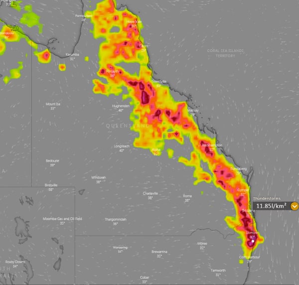
Image 1: Forecast ECMWF thunderstorm threat for Tuesday 21st January, 2020 (Source: Windy)
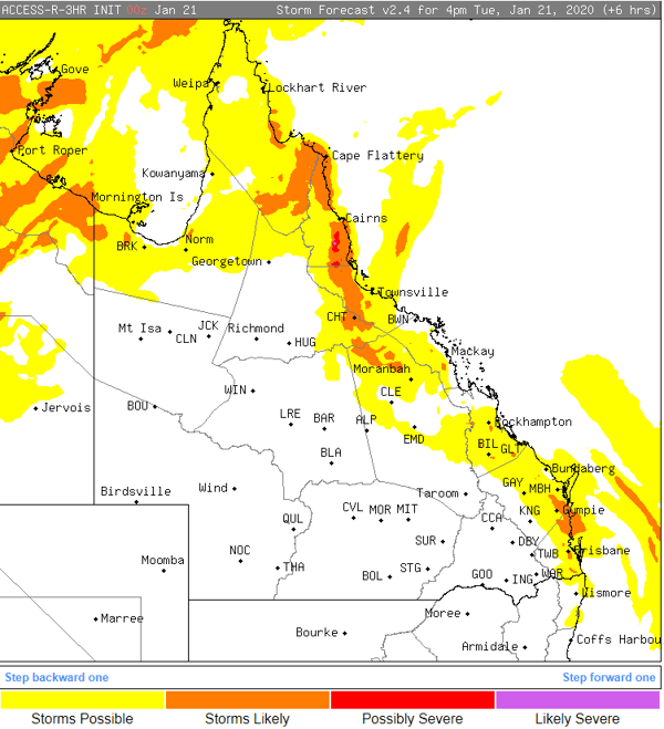
Image 2: Forecast ACCESSR thunderstorm threat for Tuesday 21st January, 2020
Severe thunderstorms containing damaging to locally destructive winds, giant to large hail and moderate to heavy rainfall have lashed Canberra today shortly after lunchtime, as a severe thunderstorm outbreak currently is occurring through central and southeastern parts of Australia.
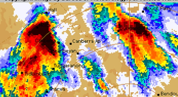
Image 1: BoM Weather Radar for Canberra, ACT as at 12:36pm, Monday 20th January 2020
At 12:01pm, severe thunderstorms were detected on the weather radar near the Brindabella Ranges, Goobarragandra (east of Tumut) and Wee Jasper and rapidly moving towards the southeast. Damaging winds and large hail were likely for parts of Belconnen, Hall, Gungahlin, Weston Creek and reaching Canberra Civic, Queanbeyan, Tuggeranong and the Canberra Airport by 1:00pm. At 12:31pm, the thunderstorm warning was upgraded to include locally destructive winds, giant hail and heavy rainfall with the thunderstorm moving directly over Canberra shortly thereafter.
Image 2: Early Warning Network Lightning Tracker, 12:35pm, Canberra ACT, Monday 20th January 2020
Damaging wind gusts of up to 117km/h was recorded at the Canberra Airport between 12:48pm to 12:53pm, and were sustained for a duration of five minutes during the peak intensity of the thunderstorm. Large hail to the size of golf balls were observed at Parliament House in the centre of the city and surrounding suburbs with large accumulations in some places.
Conditions are very favourable for the continuation of strong and destructive thunderstorms into this afternoon and evening for numerous locations situated through the eastern inland and coastal districts of southern Queensland but primarily through and eastern inland and coastal New South Wales districts, with the potential for further localised destructive winds, large hail and heavy rainfall that may be conducive to flash flooding and rises in rivers, creeks and streams.
Wet and wild weather will continue across the eastern states on Monday, with a thunderstorm outbreak likely across parts of QLD, NSW and VIC.
A strong short wave trough will amplify into NSW during the next 24 hours, inducing a surface low across northern Victoria.
Favourable wind shear (bulk shear in the 40-60kts range) coupled with strong instability and moisture is expected to lead to the formation of supercells during the afternoon and evening, particularly across southern, central and northern regions of NSW.
These thunderstorms are likely to lead to damaging to locally destructive winds, large to giant hail, frequent cloud to ground lightning and heavy rainfall that may lead to flash flooding.
Across VIC and southern NSW, very cold temperatures aloft in associated with a cut-off low will generate a strongly unstable environment. Scattered to widespread thunderstorms are expected during the afternoon and evening, with damaging winds, heavy rainfall and large hail.
Across eastern QLD, thunderstorms are likely to develop across parts of the Darling Downs and Central Highlands, with the potential for a few severe storms with large hail, damaging winds and heavy rain, before shifting east into the evening hours.
One complicating factor into this set-up, will be the amount of convection that develops overnight and if the atmosphere will have enough time to recover tomorrow. Should overnight storm activity/cloud cover linger, the severe threat will be tempered and likely to remain more isolated and not as widespread.
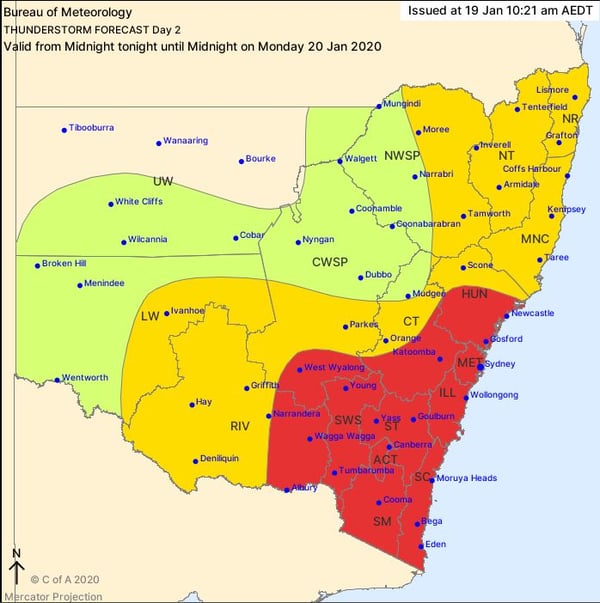
Image 1: New South Wales, BoM thunderstorm potential, Monday 20th January 2020
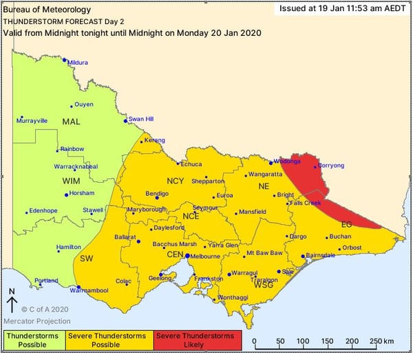
Image 2: Victoria, BoM thunderstorm potential, Monday 20th January 2020
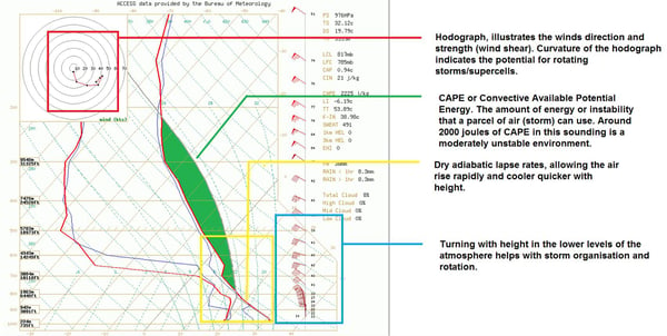
Image 3: Forecast sounding from the North West Slopes and Plains in NSW, showcasing supercell potential.
The most widespread and heaviest rain event since Ex-Tropical Cyclone Debbie hit southeast Queensland and northeast New South Wales last night and into the early hours of today, with rainfall totals in excess of 200-to-300mm leading to flash flooding across the region.
An upper level low lying over central Queensland combined with a weak surface trough (allowing convergence) and moist onshore winds to produce a band of heavy rainfall that started in the Sunshine Coast on Friday, before spreading into northeast NSW from early Saturday.
Most coastal areas stretching from Noosa to Grafton recorded between 50mm and 150mm, with some areas receiving in excess of 200-300mm. Intense rain rates associated with the event meant there was flash flooding, particularly over the Gold Coast and far northeast NSW, where some roads are closed due the flooding.
The Gold Coast Seaway recorded 255mm in the 24 hours to 9am, its heaviest January fall on record since the site opened in 1995. Nearby Loder Creek Dam registered a huge 330mm, whilst 301mm fell at Carrara and 206mm at Coolangatta.
In northeastern NSW, Clothiers Creek (near Murwillumbah) recorded 250mm to 9am, Lismore 129mm, Tumbulgum 243mm and Grafton Airport 155mm.
Some fantastic falls also extended into eastern parts of the Darling Downs and Granite Belt, with totals ranging from 50-to-90mm (including 91mm at Stanthorpe), filling tanks and dams.
Further west, unfortunately there were much lower totals, with further rain required to ease drought conditions.
A few showers and storms are likely over the weekend and into next week, although rainfall totals are not expected to be as high. However, further falls of 15-to-30mm (with isolated totals towards 50mm) are still possible, particularly under slow-moving storms.
From Monday, hot and very humid conditions are also likely to begin, with southeast QLD and northeast NSW finally feeling the sultry conditions that have been lacking so far this summer.
Image 1: Rainfall recorded in the 24 hours to 9am across Queensland and northeast NSW
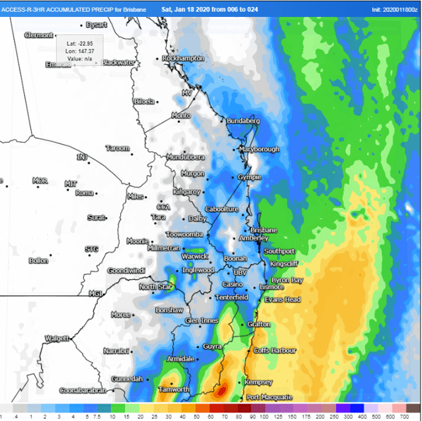
Image 2: Forecast rainfall across the next 24 hours from the ACCESSR Model (Source: Weatherwatch Metcentre)
The best rain in years drenched parts of central and southern Queensland on Thursday and into Friday morning as a moisture-laden trough caused widespread rain and storms across the region.
Humid winds sourced off the Pacific Ocean fed into the trough which lay over the interior, and generated showers and thunderstorms stretching from the Cape York Peninsula to the Channel Country, however the best falls were observed over central and southeastern parts of the state.
Widespread totals of 10-to-30mm were recorded in the 24 hours to 9am, however under the heavier thunderstorms totals were much higher with some areas seeing totals in excess of 100mm which lead to flooding.
In the state's south, Palen Creek received 178mm to 9am, its heaviest rain in seven years, whilst nearby Mount Barney recorded 154mm. 102mm fell at Jandowae on the Darling Downs, with 65mm falling in just half an hour.
Over central parts of QLD, 154mm fell at Broadmere, 90mm at Theodore, and 76mm at Emerald, the best rain in almost two years.
Today, rain and thunderstorms will continue over the state's central east and southeast, with further widespread falls of 15-to-30mm, with heavier totals in excess of 50-to-100mm under thunderstorms.
About central east and northeast QLD, thunderstorms also bring the risk of large hail and damaging to locally destructive winds.
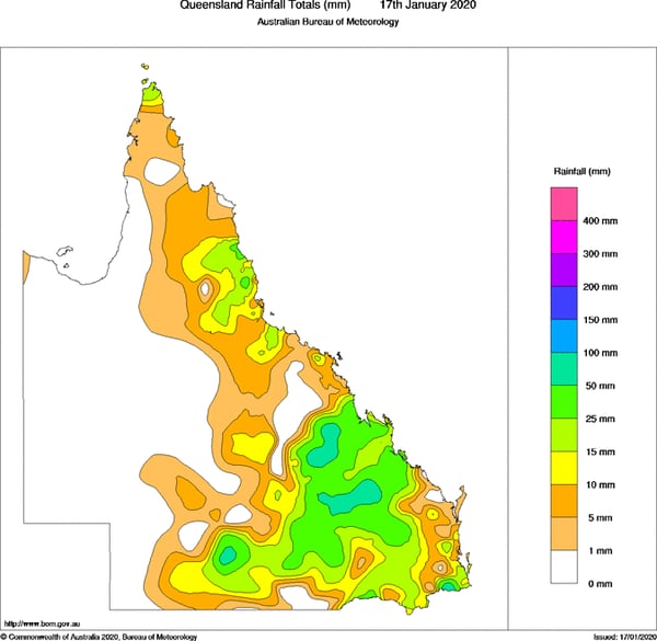
Image 1: Rainfall recorded in the 24 hours to 9am across Queensland (Source: Bureau of Meteorology)
Image 2: Forecast rainfall across the next 24 hours from the ECMWF Model (Source: Windy)
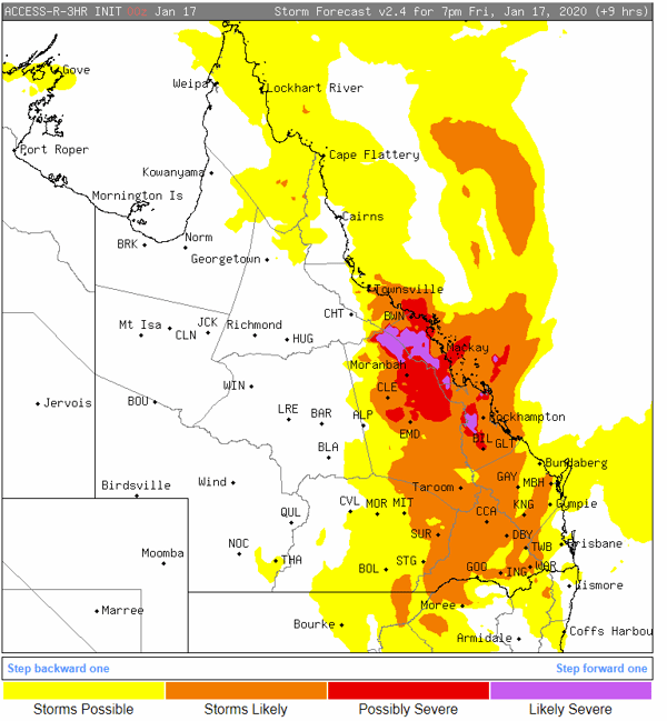
Image 3: Thunderstorm forecast across QLD for Friday 17th January, 2020 (Source: Stormcast)
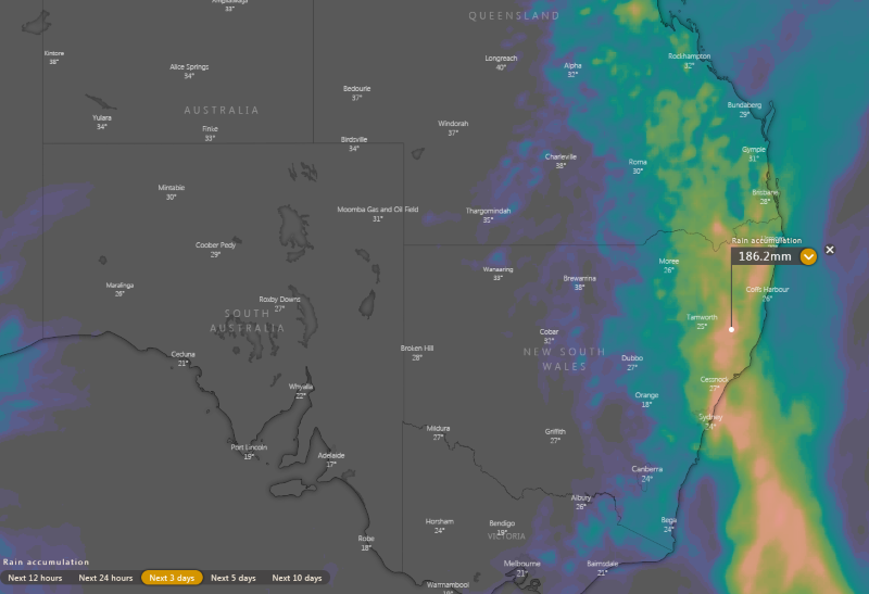
Image 1: ECMWF accumulated precipitation over the next 3 days (Source: Windy)
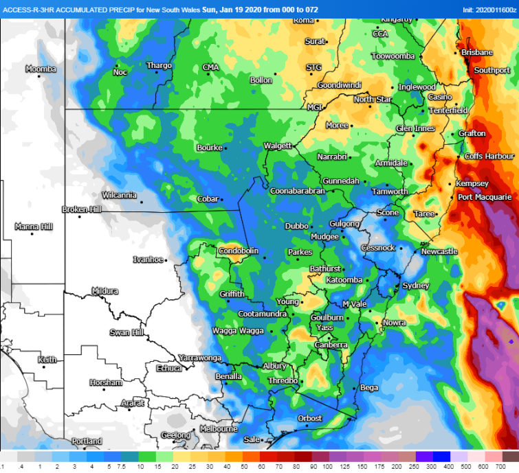
Image 2: ACCESSR accumulated recipitation over the next 3 days (Source: Weatherwatch MetCentre)
Heavy rain soaked central Victoria yesterday as thunderstorms lashed the state, bringing the best rain in a few years to some places, with the focus of the action now moving to New South Wales and Queensland over the next few days.
A trough dragged a hot and humid airmass over the state, with temperatures rising into the mid-to-high 30s and moisture levels significantly higher than other hot air masses seen this summer.
Thunderstorms developed in the morning and became more widespread during the afternoon, peaking in intensity over central parts of VIC.
Strong cells developed in the Melbourne area, with a particularly strong storm around the Avalon and Geelong area bringing wind gusts to 113km/h, large hail and as much as 24mm in just 10 minutes. The eventual total of 49mm at Avalon was the site's heaviest fall since April 2017.
Many parts of the Central and North Central received totals in the 10-to-20mm, however some places saw even heavier totals, including Tullamarine (31mm), St Albans (77mm), Kinglake (35mm) and Mount Baw Baw (40mm), the best falls in more than a year for some of these places.
These thunderstorms tracked eastwards into east Gippsland and the northeast during the evening, however they unfortunately weakened. The most notable totals included 17mm at Waterford (near Dargo) and 19mm at Gelantipy, which fell over some fire affected areas.
Thunderstorms have cleared the state, with the focus now on the eastern half of NSW and QLD over the next few days.
Heavy falls have already been recorded today, although they have been patchy. Some notable falls in NSW include (to 3pm EDT): 70mm at Buldahdelah, 47mm at Mullaley, 59mm at Bendemeer and 45mm at Moree. In QLD, Blackwater recorded 63mm in the 24 hours to 9am, whilst Longreach had a wind gust to 98km/h.
Further widespread falls of 15-to-30mm are likely over eastern parts of central and northern NSW and southern QLD over the next three days. Some areas will receive significantly heavier falls, particularly on the slopes, ranges and just inland from the coast, with totals of 50-to-100mm and isolated heavier falls up to 150-200mm.
This system will clear off the coast around Sunday, however another rain bearing system is due next week, with potentially severe thunderstorms as well.
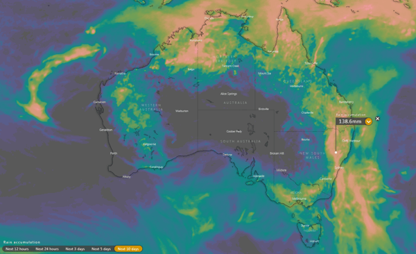
Image 1: ECMWF accumulation precipitation over the next 10 days (Source: Windy)
Image 2: GFS accumulation precipitation over the next 10 days
There has been growing optimism over the last few days about widespread rain across eastern Australia across the next week, with computer models now agreeing many parts of Australia's east are likely to see their best summer rain in several years.
Moisture has been building across the nation in response to the monsoon and a breakdown of two climate drivers that have been keeping the nation dry - the Indian Ocean Dipole and Southern Annular Mode.
A near stationary low pressure trough over the east of the nation is now being fed by this moisture, and will also be aided by a series of upper level troughs, which will generate rain, showers and thunderstorms over Victoria, New South Wales and Tasmania across the next week at least.
Isolated showers and thunderstorms will develop over the interior today, whilst showers will affect parts of the QLD and northeast NSW coast, before rain becomes more widespread and heavier from tomorrow and spreads south into Victoria.
Across the next week and a half, widespread falls of 20-to-40mm are expected, however some areas, particularly over the central and northern NSW coast and ranges, are likely to see totals of 50-to-100mm, with isolated heavier falls under more intense thunderstorms.
Over Victoria, there is more uncertainty depending on the movement of an upper level trough, however many areas can still expect 15-to-30mm, with some areas seeing totals closer to 50mm - although this is subject to change.
The great news is that a lot of this rain is likely to fall over the firegrounds. This will likely help extinguish some fires, and reduce activity in other fires. The damper vegetation will also mean the threat of fires will be lower at least for several weeks, and any new blazes won't be as intense either.
Within this event, there are likely to be thunderstorms as well, with some days bringing potential for these to become severe. Flash flooding will be the main threat with this system, however damaging winds and large hail are also a chance.
With the whole of NSW drought declared (and large parts of VIC and QLD), this rain will be a great way to kick off the new year.
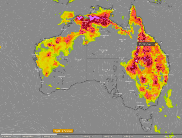
Image 3: Thunderstorm Forecast for Thursday 16th January, 2020 (Source: Windy)
After a dry start to 2020 for eastern Queensland and New South Wales, signs of pattern change are underway as the monsoon season kicks off across northern Australia, a positive IOD (Indian Ocean Dipole) breaks down and the SAM (Southern Annular Mode) returns to more neutral territory.
During Saturday, thunderstorm activity is expected to develop across northern NSW along a surface trough, with a gusty southerly change surging up the NSW coast. As the evening progresses, this activity is expected to shift north into southern QLD, with the potential to provide moderate falls under storm activity.
Overnight Saturday and into Sunday morning, a southerly change will continue to move north through northern NSW and southern QLD. This change is likely to inject further moisture into a surface trough across the Darling Downs and in combination with cold upper level temperatures, produce scattered showers, storms and rain periods.
Widespread falls of 10-20mm are expected east of the Great Dividing Range, with heavier falls likely closer to the coast fringe, with some regions likely to see up to 50mm over the two-day period.
Localised thunderstorm activity will have the potential to enhance falls, which may produce localised flash flooding.
Showers are likely to continue during Monday as a moist onshore flow persists, with thunderstorm activity likely across inland parts of the state. During next week, scattered, tending widespread storm activity may develop across inland NSW and QLD.
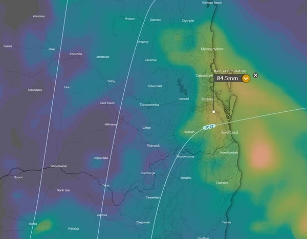
Image 1: EC accumulation precipitation over the next 5 days
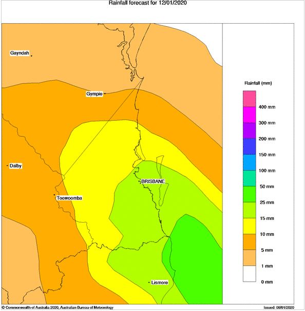
Image 2: NoM PME forecast rainfall for Sunday 12/1/2020
Another burst of heat and strong winds are set to cause bushfires to flare up again on Thursday and especially Friday, however a cooler change and increased moisture is finally set to bring a proper reprieve to Australia's southeast from the weekend.
Northerly winds ahead of a trough and cold front are dragging down an intensely hot airmass from the interior, with temperatures pushing into the low to mid 40s across South Australia, NSW and northern Victoria on Thursday. Some parts of NSW have had an intensely hot start to January, running five-to-ten degrees above average so far.
In South Australia, northerly winds will be moderate and gusty at times, before a gusty southerly change begins to push into coastal areas during the afternoon and evening. This will cause fire danger to reach severe across the south, with the most dangerous times expected during the afternoon (during peak heating and northerlies) and on the frontal boundary. Some light rain is expected in the evening and overnight in coastal areas.
Fire weather will become more dangerous on Friday as the airmass becomes even hotter and winds become stronger, with fire ravaged eastern Victoria and NSW likely to see the most intense conditions once again.
Temperatures will soar from the low 40s to high 40s, with strong and gusty northwesterly winds pushing across the region ahead of the change, with gusts reaching 50-70km/h across southern NSW and eastern Victoria. Northeasterly winds will prevent significantly hot weather on the NSW South Coast.
However, the most dangerous aspect of this system will be the squally southerly change associated with the change, with wind gusts in excess of 80-90km/h expected across eastern VIC and southern NSW during the afternoon and evening.
This will cause any current fires, including the massive Currowan Fire and the Border fire near Eden to spread rapidly north on the frontal boundary and a few hours after the change, before conditions ease. In the wake of the change, some light rain is also expected across the fire ground.
Thankfully, there is good consensus amongst computer models now that fire potential over the coming weeks will drop. Winds are expected to ease, temperatures become a little cooler, and a more easterly flow is expected to develop.
Some models indicate increased chances of rainfall in mid-to-late January, although it is too early to say how much and where this will fall.
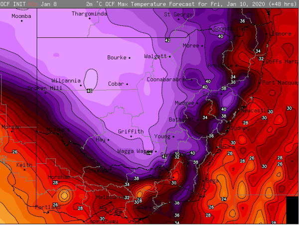
Image 1: OCF Forecast Maximum temperature for NSW and Victoria for Friday 8th January, 2020
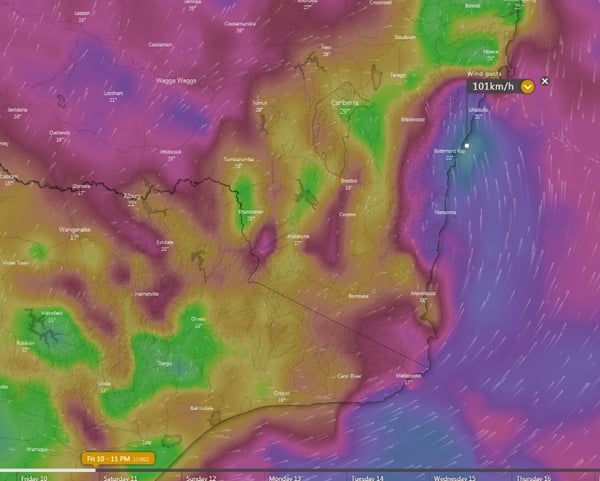
Image 2: Strong wind gusts associated with the southerly change during Friday 8th January, 2020 evening
Thunderstorms developed over central and northern inland parts of NSW yesterday, bringing much needed rain to the drought struck state, with some locations seeing their best falls in almost a decade.
As tropical activity has increased over the country, and the climate drivers behind the severe drought breaking down, moisture has been building over NSW in recent days.
A low pressure trough provided the forcing needed for thunderstorms yesterday, with weak wind shear causing thunderstorms to be slow-moving and generally not severe. .
However, due to the slow-moving nature of the storms, some areas got some very good falls, whilst other areas received only light totals (or missed out completely).
Guyra (Box Point) received 65mm in the 24 hours to 9am today, its heaviest fall since November 2011. Gowan Brae (east of Guyra) also recorded 65mm to 9am, however Guyra township only registered 6.4mm, showing the patchy nature of the falls.
Other notable totals included 36mm at Murrurundi (heaviest rain since March, and for January in four years), 29mm at Granite Heights and up to 38mm in the Elsmore area.
A line of thunderstorms also pushed through the Illawarra, Blue Mountains and Sydney last night near a weak southerly change, dropping a barrage of cloud to ground lightning strikes, although thankfully not sparking any major fires. Totals with this line were only light, with the highest falls 15mm at Wollongong, and 12mm at Wentworth Falls and Camden.
Thunderstorms are developing again today over the central and northern ranges, and are expected on Thursday as well over the state's central inland and north. Falls are likely again to be patchy, although totals aren't expected to be as high as yesterday.
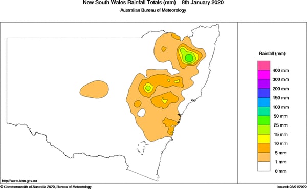
Image 1: Rain totals in the 24 hours to 9am today
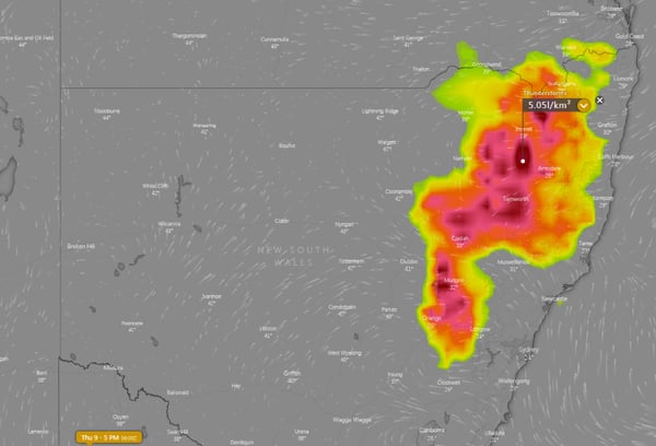
Image 2: Thunderstorm forecast for tomorrow across NSW from the ECMWF Model (Source: Windy)
A tropical cyclone off the Top End is becoming increasingly likely by the middle of this week, as a tropical low over the Arafura Sea continues to intensify.
The Tropical Low is currently located 195km north-northeast of Nhulunbuy and is slow-moving, and is likely to take on a more west-southwest path tonight.
The low will continue to intensify as it continues on this path, and may develop into a tropical cyclone by Wednesday night or early Thursday morning. The Bureau of Meteorology indicates the system has a high chance of being a tropical cyclone by Thursday or Friday, and will be named 'Claudia' if this happens, and the second tropical cyclone of the 2019/2020 season.
Current prognosis suggests the system may reach category 2 strength by late on Thursday, before making landfall (most likely somewhere between Croker Island and Elcho Island) around Friday and weakening. Very heavy rainfall leading to flooding, storm surge and very strong winds are possible near the system.
Tropical Cyclone tracks are difficult to predict, however models currently indicate a westward movement towards WA, possibly bringing heavy rain and strong winds to Darwin along the way, although its uncertain how strong the system will be if it passes near the city.
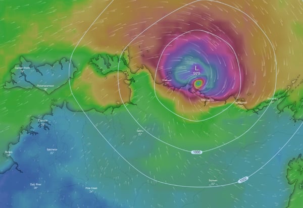
Image 1: Rain and synoptic of the tropical system on 4am Friday 10th January, 2020 (Source: Windy)
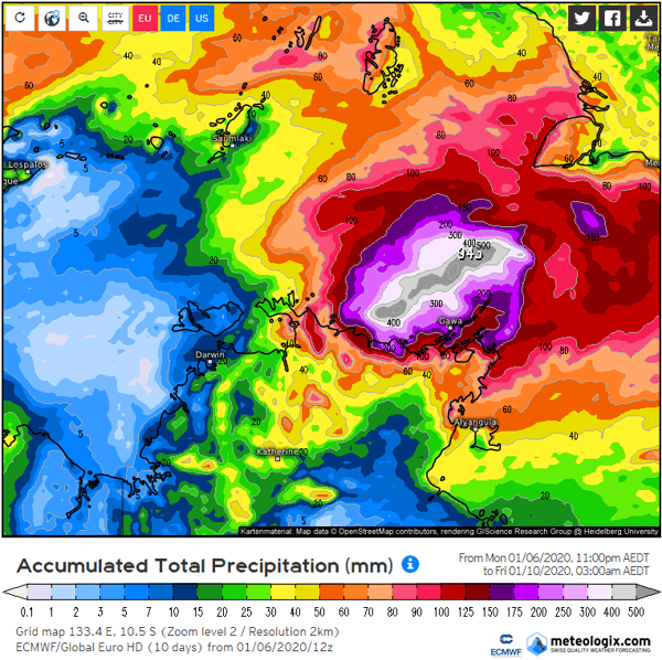
Image 2: Accumulated rainfall until 3am Friday 10th January, 2020 (Source: Meteologix.com)
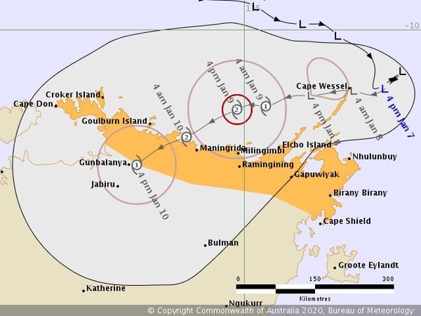
Image 3: Current forecast track of the tropical low/cyclone
It's good to see that over the last couple of days, patchy mainly light rainfall, more moisture, much cooler temperatures and weaker winds have eased fire dangers right back. This has allowed fire fighters much needed breathing space to make more progress in fighting the many bushfires burning in the region though there are still many fires which are uncontrolled.
However most of the rainfall totals over the last couple of days have been below 10 mm which is nowhere near enough to put out large fires and in certain situations such light falls can sometimes cause problems such as interfering with backburning that helps strengthen containment lines.
Looking ahead, most of the showers and patchy light rainfall caused by an upper trough should gradually contract east this evening to become confined to the NSW side of the border though some very patchy light shower activity may persist in parts of the Gippsland over the next few days.
Meanwhile fire affected parts of the NSW south coast should still see some shower activity continue for the next few days thanks to onshore moisture feeding into a trough lying to the west. The southern ranges including the Snowy Mountains area should also see some shower activity continue with some afternoon and evening storm activity during the next few days.
Unfortunately Friday is expected to see fire danger increase once again as hot gusty winds develop ahead of an approaching cold front though for the NSW side of the border they may not be quite as extreme as what we've seen a few days ago.
A band of showers and patchy rain with the front is then likely to move across East Gippsland but this rainfall is expected to be lighter and patchier for the NSW side of the border. The front will be followed by cooler temperatures again.
Image 1: Pictured here are the rainfall amounts that fell in the 48 hours up to 9 a.m. this morning.
As at 9:00am (WST) this morning, Category 1 Tropical Cyclone Blake has been named and is the first Tropical Cyclone to exist in Australian waters for 2020. Blake has developed over the waters to the north of Broome and is likely to produce gales along the northwestern Kimberley Coast today with a Warning Zone extending from Kuri Bay in the north to De Grey in the south including Broome.
TC Blake's exact location is estimated to be 240kms north of Broome and 270kms west of Kuri Bay with an eastward trend at an estimated 9km/h. Currently, the central pressure of the system is 993hPa and producing wind gusts over water to 100km/h.
The Tropical Cyclone is expected to further intensify into tomorrow with a predicted southwestern track towards the northern WA coastline due to a mid-level ridge, essentially steering the centre of the cyclone adjacent the Dampier Peninsula over the next 24 hours.
Further ahead into Wednesday, the centre of Tropical Cyclone Blake (potentially a Category 2 system) is expected to lie to the west of Broome during the morning before dipping south-southwestward to the northeast of Wallal Downs.
There is a risk that if TC Blake edges closer to the coastline than anticipated, that land interaction and friction may attribute to the brief suppression of intensity, however at this stage the centre of the system is expected to remain just offshore adjacent Broome (this is still subject to change). Some road closures are in effect early including the unsealed section of Broome Cape Leveque Road in the Shire of Broome.
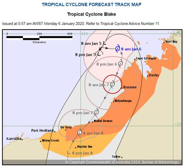
Image 1: Tropical Cyclone Blake Forecast Track Map as of 8:57am on Monday, 6th January 2020.
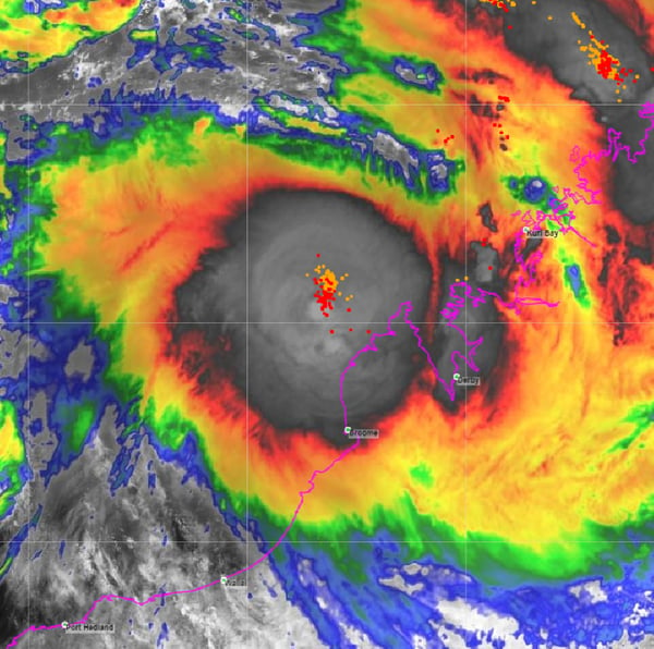
Image 2: Satelite imagery of Tropical Cyclone Blake adjacent the Kimberley Coast - Monday, 6th January 2020
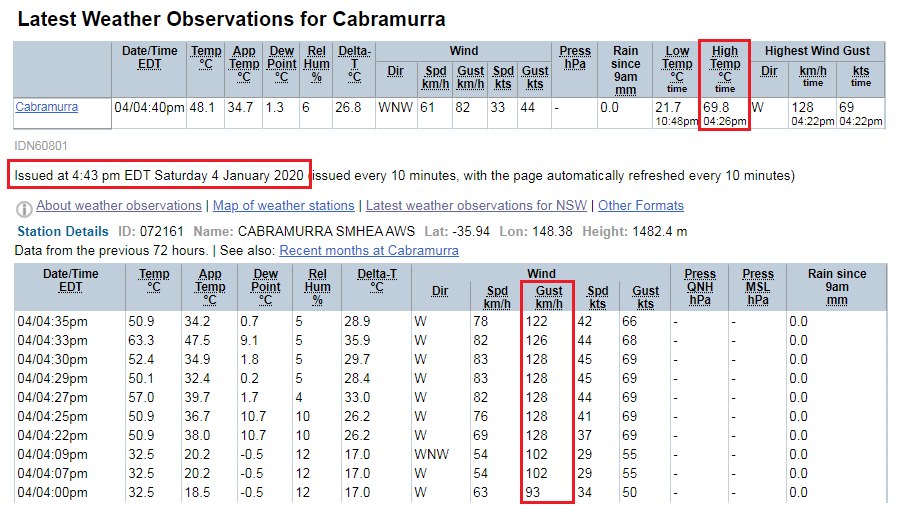
Image 1: BoM observations for Cabramurra, NSW.
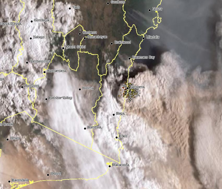
Image 2: EWN Satellite image, southern NSW and VIC
Record breaking heat struck parts of NSW on Saturday, as raging fire caused havoc across southern NSW and eastern Victoria.
Penrith, in western Sydney, recorded its highest temperature on record, reaching a staggering 48.9°C yesterday afternoon, smashing the old site record of 47.3°C. This made it the highest temperature every recorded in the Sydney basin, and the third-highest temperature ever recorded in NSW.
The heat wasn't localised to the Sydney region, with Canberra also recording its highest temperature on record. The mercury climbed to 43.6° in our nation's capital during the afternoon hours.
Sadly, this extreme heat, low humidity and gusty wind help to produce the perfect fire conditions across these regions, with 25 emergency warned fire and 21 watch and act fires flaring up during the late afternoon.
The Bureau of Meteorology in NSW and VIC issued severe thunderstorm warnings during the afternoon for fire-initiated thunderstorms. These firestorms were warned for damaging to locally destructive winds, with the potential to produce cloud to ground lightning and fire tornadoes.
Cabramurra, in the Snowy Mountains of NSW was a victim of these firestorms, with destructive wind gusts peaking at 128km/h around 4:30pm with a temperature of 69.8°C (fire driven temperature).
A southerly change moved up the NSW coast late yesterday, with cooler conditions expected during Sunday. A north-west cloud band should provide some patchy showers across the fire ravaged regions over the next day or two, with the potential for further showers, rain periods to develop late next week.
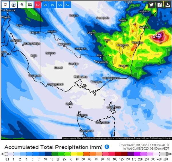
Image 1: EC Accumulated precipitation. Tropical Tidbits
Over the past 4 months, Australia has been in an all-out war against raging bushfires, with Western Australia, South Australia, Queensland, Tasmania, New South Wales and Victoria all experiencing emergency warned fires.
Since these horrific fires began in August 2019, an estimated 5,900,000 hectares (59,000 km2 or ~15,000,000 acres) have been burnt, over 2500 buildings (including 1300 homes) have been destroyed and at least 18 people have sadly lost their lives making this the most destructive bushfire season on record.
60,700 km2 of burnt land sounds, and is a lot. But let's put that into perspective. Sri Lanka is 65,610 km2 in size, with Tasmania 68,401 km2, Ireland 84,421 km2 and the North Island of NZ at 113,729 km2. This showcases the enormity that our country has been facing.
Sadly, these fire conditions culminated on Monday (30th December 2019) as devastating firestorms ripped through the East Gipplsland in Victoria and South Coast of NSW, with 17 people still unaccounted for.
During Friday and into Saturday, conditions are expected to deteriorate once again, with numerous severe to extreme fire dangers expected for WA, SA, VIC, NSW and TAS as another burst of very hot and dry air is dragged down from north-western Australia.
Temperatures will once again soar into the low to mid 40's across southern and central Australia, before a strong and blusterly southerly change sweeps up the eastern Victorian and NSW coastline late Saturday.
Soaring temperatures and gusty winds won't be the only fire threat during this period, with the potential for high based thunderstorm activity to develop, with dry lightning once again posing a serious threat. These conditions are likely to exacerbate the current fire crises across Victoria and NSW.
However, there is a glimmer of hope on the horizon. A low pressure trough is expected to deepen late into the weekend, with increasing moisture to its east, generating showers, isolated thunderstorms and patch rain with falls in the 5-20mm region likely. Whilst this rainfall won't be Drought breaking, or completely alleviate the fire danger, it will be a welcome relief for our emergency services.
There is also the potential for a tropical low, or Cyclone to develop off the Western Australian coastline early next week as the Indian Ocean Dipole (IOD) continues to steadily break down (IOD is currently at +0.56 and declining. Once this value reaches +0.4 it is considered as neutral). Should this happen, the potential for moisture to be dragged east increases, with the potential for follow-up rainfall.
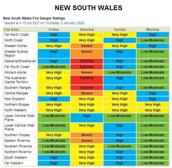
Image 2: NSW fire threat. Image via Bureau of Meteorology.
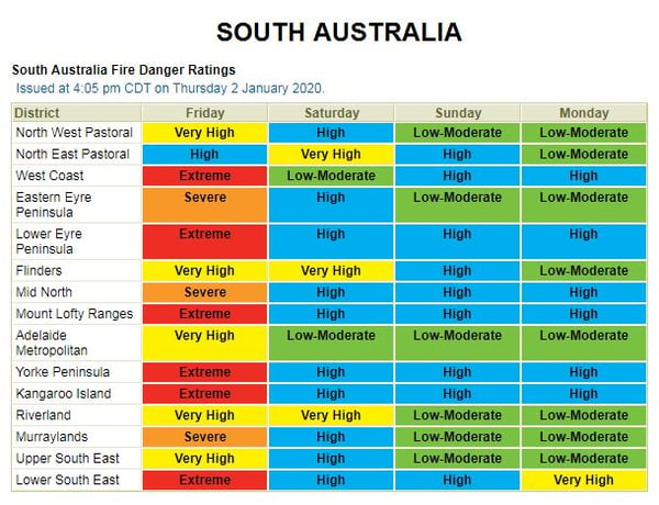
Image 3: SA fire threat. Image via Bureau of Meteorology.
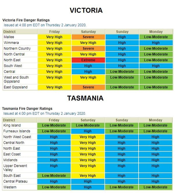
Image 4: VIC and TAS fire threat. Image via Bureau of Meteorology.
Image 1: Operational Consensus Forecast max air temperature for Saturday 28/11/2020. Image via...
While severe weather has hammered northern Australia over the past few months, the focus has...
It was a testing Thursday for emergency services across New South Wales as fires, dust and strong...