Welcome rainfall on the way for northern NSW and southern Queensland
After 20 consecutive days without rain, the longest period since a 21-day stretch over May into...
On Tuesday, the Bureau of Meteorology issued an El Niño alert, with a 70% chance of El Niño later in 2023. This is nearly three times the normal chances of an El Niño forming. However, the U.S Climate Prediction Center has issued an El Niño Advisory - meaning El Niño conditions are present and will continue to strengthen over the coming months.
After Australia registered its second driest May on record in 2023, below-average rainfall is predicted for the remainder of winter as an increasingly likely El Nino develops, which will maintain a drying trend across spring and summer.
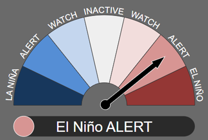
Bureau of Meteorology has put Australia on an El Niño alert. Image via BoM
So, what can Australia expect if this El Niño alert moves into an El Niño event?
Reduced risk of rainfall for eastern Australia
Drier than average conditions may put stress on dam storage for major cities and towns, increasing the importance for councils to make quality decisions on water restrictions.
Warmer daytime temperatures, with the risk of extreme heatwaves
Heatwaves present a significant threat to humans, animals, livestock, and the agricultural industry, as well as placing tremendous pressure on our already struggling electrical grid.
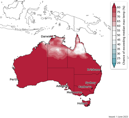
Chance of above medium maximum temperatures for July to September 2023. Image via Bureau of Meteorology.
The Early Warning Network’s Climatic database demonstrates a clear trend in heatwave frequency across southeastern Australia. Using Perisher Valley as a plotting region, the number of heatwave days has shown an increasing trend of frequency (significantly positive (p=0.0023) across the past few decades, including extreme heatwave events.
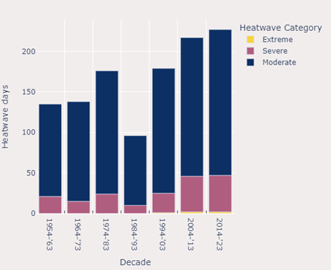
Early Warning Network’s Climatics database – Heatwave events steadily increasing in frequency over the past few decades.
A significant increase in the threat of bushfire danger in southeastern Australia, particularly moving into early spring and summer
Above normal fire potential will develop through winter for parts of NSW and the Northern Territory, with below normal fire potential across the Great Diving Range of NSW. Normal bushfire potential is expected elsewhere across the country.
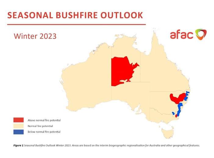
AFAC season bushfire outlook for winter 2023.
A decrease in snow depth across the ski fields of southern Australia
A decreasing snow depth would greatly impact the tourism industry across this region, with many Australian holiday makers to look at winter trips to New Zealand or further abroad. This would lead to a significant flow-on effect for Australia’s ski fields, associated businesses, and employees that rely so heavily on seasonal holiday makers.
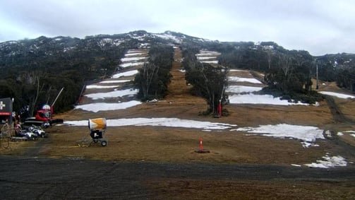
Still image from Thredbo ski resort - June 2023. Picture via ski.com.au
A reduced number of tropical cyclones as well as a later onset to the northern wet season
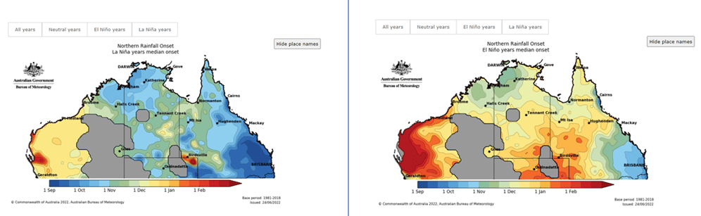
Northern Australia rainfall onset - El Niño years vs La Niño years. Image via Bureau of Meteorology.
Explore EWN's Climatics or contact us for more information about how our forecasting services can help your business.
After 20 consecutive days without rain, the longest period since a 21-day stretch over May into...
Regions across the Northern Territory and Western Australia are currently facing significant...
Thunderstorms are on the menu for southern Queensland and NSW this week. Kicking off late Thursday...