Severe thunderstorms lash South-East Queensland, with heavy rainfall and even a waterspout
Parts of South-East Queensland have been lashed by severe thunderstorms over the last 24 hours,...
The afternoon of Thursday 28 September will see thunderstorm activity return to South East Queensland, with any rainfall across the region a welcome relief.
A southeasterly change will work its way up the northern NSW coastline and into South East Queensland during the late morning hours. Normally, a southeasterly change moving through so early in the day would inhibit stronger storm activity, however, this will be a modified southeasterly change – meaning that the cooler, gusty conditions usually associated with a southeast change won’t occur until much later in the day. The exception will be along the extreme coastal fringe, with surface temperatures expected to drop several degrees with its passage – increasing a capping inversion across this region.
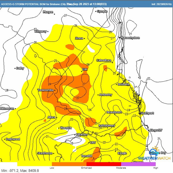 ACCESS G Storm Potential & Surface Temperatures (contours) for 1pm Thursday. Image via WeatherWatch MetCentre.
Western regions of SEQ will still be in the firing line during the afternoon hours, with warmer surface temperatures expected to continue late into the day. Warm surface temperatures, in conjunction with increasing moisture associated with the southerly change, will undercut an upper trough passing over the region, adding enhanced lift with very cold temperatures aloft.
Scattered storm activity will result, with storms likely to form across the higher terrain of northern NSW, extending into the Border Ranges region of SEQ. This activity will steadily progress north during the afternoon, with activity likely to favour elevated terrain and the western ranges of SEQ – extending into the Lockyer, Brisbane Valley, and southern Wide Bay and Burnett.
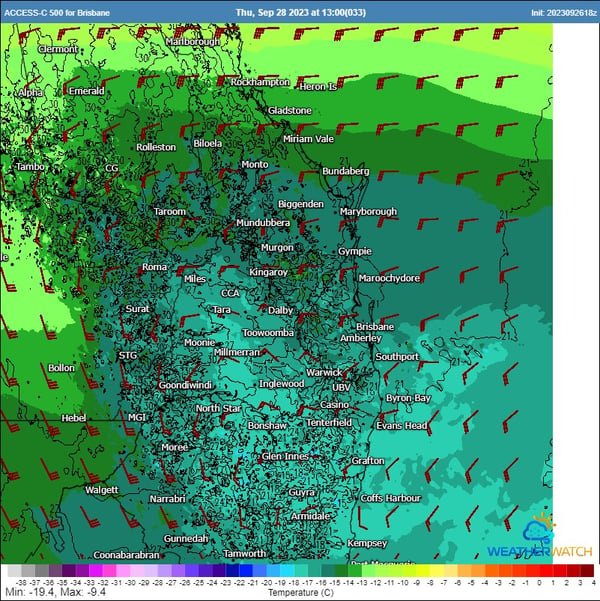 ACCESS C 500mb winds & temperatures for Thursday. Image via WeatherWatch MetCentre.
Although wind shear isn’t overly supportive of well-organised storm activity, turning in the low levels of the atmosphere along with orographic lifting, and a slab of cold air aloft may help enhance the threat for an isolated severe storm or two capable of producing localised large hail, locally damaging winds, and an isolated heavy rainfall threat with slow-moving storms.
Further west into the Darling Downs region, temperatures into the early 30s and slightly less moisture (being a little further west from the southerly change) will see higher-based storms develop. Drier air at the surface will help to promote the threat of damaging wind gusts in the form of microbursts, along with localised large hail. Pockets of isolated heavy falls may also develop with any clusters of slow-moving storms associated with weak wind shear.
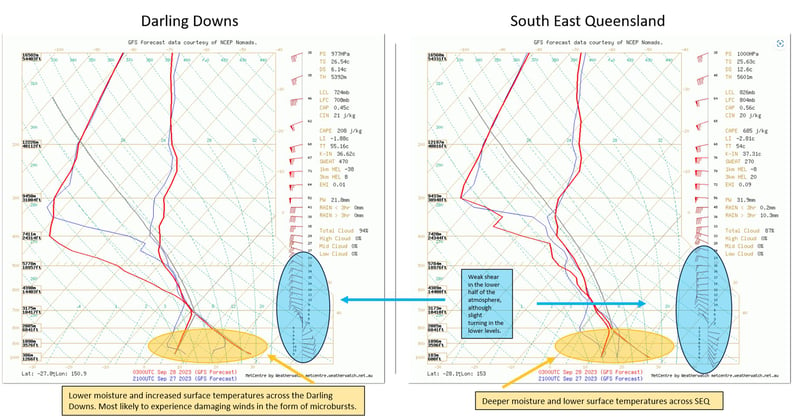 GFS soundings for Thursday afternoon across. Darling Downs vs South East Queensland. Image via WeatherWatch MetCentre.
Residents in the affected areas are advised to stay alert and be prepared for potential severe weather conditions. Early Warning Network offers a variety of forecasting and warning technologies to assist in mitigating the risk posed by severe weather events. Customised wind and thunderstorm alerts give you timely information about locations in the path of storms before they are impacted, and our hail defence services are the leading hail forecasting and alerting products in Australia, protecting assets and people from damaging hailstorms.
If you would like to talk with our team about how these and other products can help you prepare for severe weather and hazards, chat to our team today.
Parts of South-East Queensland have been lashed by severe thunderstorms over the last 24 hours,...
Severe thunderstorms containing damaging to locally destructive winds, giant to large hail and...
As the tropical low in the Coral Sea intensifies, it's crucial for residents in eastern Queensland...