Early Warning Network Partners with Bush Heritage Australia
The Early Warning Network is proud to announce a new Corporate Partnership with Bush Heritage...
As the tropical low in the Coral Sea intensifies, it's crucial for residents in eastern Queensland to stay informed and prepared. The system, expected to be named Cyclone Kirrily by the Bureau of Meteorology, is brewing into a significant weather event. Here's what you need to know:
 Issued at 11:15 am AEST Tuesday 23 January 2024 by BoM
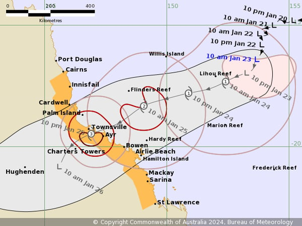
Initially a tropical low, this system is on track to become a tropical cyclone named Kirrily tonight. Forecasters predict it may intensify to a category three strength as it nears eastern Queensland. Should Kirrily reach category 3 intensity, it could unleash maximum mean winds ranging from 118 to 159 km/h and even stronger gusts reaching 165 to 224 km/h.
The current trajectory suggests Kirrily will make landfall along the Queensland coast between Thursday morning and Thursday night. The specific area at risk spans from Innisfail to Airlie Beach. It's vital for those living in or near these regions to closely monitor the cyclone's path as it evolves.
The approach of Cyclone Kirrily warrants significant concern, with the Bureau of Meteorology making it clear that there is a lot of rain associated with this event.
Anticipated impacts include heavy rainfall, destructive winds, and a dangerous storm tide leading to potential coastal flooding. A cyclone watch has been issued, covering the coast and inland areas from Ayr to St Lawrence, including Mackay. Residents should stay vigilant and follow the latest updates and advisories from local authorities.
Gales and Damaging Winds: Gales with damaging wind gusts up to 120 km/h are expected to develop around the Whitsunday Islands from Wednesday afternoon and may extend to mainland communities between Townsville and St Lawrence overnight into Thursday. These gales could further extend northward to coastal and island communities between Cairns and Townsville during Thursday.
Destructive Wind Gusts: Destructive wind gusts up to 155 km/h may occur in coastal and island communities between Cardwell and Proserpine, including Townsville and the Whitsunday Islands, during Thursday.
Heavy Rainfall and Flash Flooding: There is a high risk of heavy rainfall leading to flash flooding in coastal areas between Townsville and St Lawrence from late Wednesday. This risk extends north to Cairns during Thursday and into Friday. Intense rainfall near and south of the cyclone, especially during its coastal crossing, could lead to dangerous and life-threatening flash flooding. A flood watch is in effect for these areas.
Even after making landfall and weakening, Kirrily is expected to continue affecting a vast region. It could bring sustained heavy rains and winds across central, southern, and southeast Queensland, extending possibly into northern New South Wales. This aftermath raises concerns about widespread flooding across eastern Australia.
From Friday, the cyclone is expected to transform into an inland rain depression, potentially causing heavy rainfall across central and southern Queensland into the weekend as the system moves inland and south.
In response to the looming threat, officials are urging residents to prepare. This includes ensuring a sufficient supply of essentials, such as non-perishable food and water, for at least 72 hours, and keeping electronic devices charged. Police are advising against non-essential travel, emphasising the dangers of driving through floodwaters. Recent incidents underscore the seriousness of this advice and the legal consequences of ignoring safety measures.
It is crucial for everyone in the affected areas to stay informed and prepared. Adhering to official advice and taking proactive measures can significantly reduce the risks associated with this cyclone. At the Early Warning Network, we specialise in providing comprehensive severe weather forecasting and alert services. Our expertise includes severe thunderstorms, wind, lightning, and flood monitoring, ensuring you stay ahead of the curve in weather preparedness. Additionally, our Tropical Cyclone services offer crucial insights and updates, helping you and your community stay safe and informed.
For further information on how we can help your business & assets stay safe, contact our team today.
The Early Warning Network is proud to announce a new Corporate Partnership with Bush Heritage...
Twenty-six years ago, on the evening of April 14, 1999, Sydneysiders watched in awe as a seemingly...
As of tonight , Wednesday, May 21st, 2025, communities across the Mid-North Coast and Hunter...