Relentless humidity finally easing across Queensland and northeast New South Wales
The relentless humidity levels that have been plaguing parts of Queensland and northeast New South...
NRL Grand Final attendees won’t just be treated to a cracking game of football as two of the best Rugby League teams of 2023 go head-to-head.
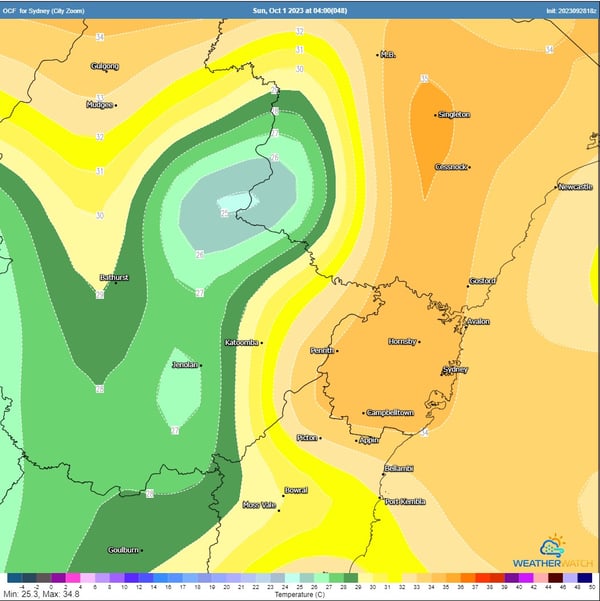 OCF forecast maximum temperatures Sunday afternoon. Image via WeatherWatch MetCentre.
Sweltering conditions will develop across NSW this weekend, with Sydney expected to hit a whopping 36°C on Sunday afternoon. Should this maximum be reached, it would be Sydney’s Observatory Hill’s hottest day since January 26th, 2021 when conditions reached 37.1°C.
Meanwhile at Sydney Olympic Park where the Grand Final will take place, 36°C is expected on Sunday. If this temperature eventuates, it make it the hottest Grand Final day in the NRL era (both Sydney Olympic Park and Sydney Observatory Hill), eclipsing the South Sydney Rabbitohs vs. Canterbury Bulldogs from 2014 which reached a high of 34.7°C. Thankfully, conditions should cool off dramatically by 7:30 pm AEDT with temperatures dropping back into the mid-20s. Spare a thought for the Women’s NRL Grand Final though - with kick-off scheduled for 3:55 pm AEDT, game time is at peak heat levels.
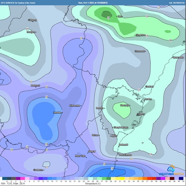 GFS surface temperatures approaching kick-off. Image via WeatherWatch MetCentre.
A cold front and trough will approach from the west during the day with increasing west-northwesterly winds, dragging hot air from the interior of Australia across the east coast. Widespread gusts of 40-60km/h can be expected, with gusts to 90km/h likely across southern parts of NSW and alpine regions.
Dry conditions will accompany hot and gusty winds with a significant fire threat likely to develop, particularly for the Hunter, Greater Sydney, Illawarra, and South Coast.
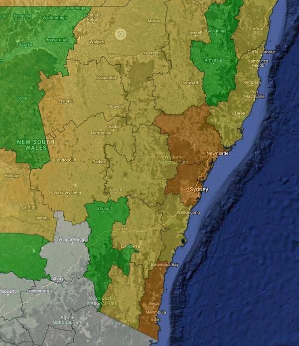 Extreme fire danger expected to develop for parts of NSW on Sunday - Greater Sydney and Hunter regions included.
Residents in the affected areas are advised to stay alert and be prepared for potential severe weather conditions. Early Warning Network offers a variety of forecasting and warning technologies to assist in mitigating the risk posed by severe weather events. Customised wind and thunderstorm alerts give you timely information about locations in the path of storms before they are impacted, and our hail defence services are the leading hail forecasting and alerting products in Australia, protecting assets and people from damaging hailstorms.
If you would like to talk with our team about how these and other products can help you prepare for severe weather and hazards, chat to our team today.
Subscribe to our blog to receive weather insights from the Early Warning Specialists
The relentless humidity levels that have been plaguing parts of Queensland and northeast New South...
After 20 consecutive days without rain, the longest period since a 21-day stretch over May into...
Much of NSW is seeing extreme temperatures across the state this week, with a catastrophic fire...