The relentless humidity levels that have been plaguing parts of Queensland and northeast New South Wales, and even extending into central NSW, are finally expected to ease in the coming days. This news brings a sigh of relief to many who have been enduring the stifling conditions.
Throughout January, the humidity has been at record-breaking levels, with dew points reaching the mid to high 20s. In certain areas of northeast NSW and the Gold Coast, the humidity has even reached 100 percent during the peak of the day, causing the unusual occurrence of fog in the midst of summer.
 Brisbane has suffered through weeks of record-breaking humidity (image by seb. on Unsplash)
Thankfully, there is relief on the horizon. As the remnants of Ex-Tropical Cyclone Kirrily gradually move away from the coastline and a burst of southeasterly winds arrive, humidity levels are projected to drop. A cold front is also expected to sweep across large parts of the country on Thursday, bringing a drier airmass. This change in weather patterns will provide some respite from the relentless humidity for those in Queensland and NSW.
However, unusually high levels of moisture have been persisting for some time, even before Kirrily formed. So why has humidity been so high, particularly in an El Nino year?
There are several factors believed to be responsible. Firstly, the sea surface temperatures around Australia have been abnormally high. This has resulted in the air holding more moisture due to the warmer conditions, and the persistent onshore winds blowing off these warm waters have contributed to the elevated humidity levels.
Secondly, there has been a lack of cold fronts crossing the country this summer, allowing these persistent onshore winds to continue and allow moisture levels to build up, without moisture being flushed out by these cold fronts. This is also what is causing the lack of hot days across the nation's southeast this summer, as strong cold fronts typically drag hot air from the interior ahead of them in northerly winds.
.png?width=600&height=508&name=image%20(13).png) Image shows the relative humidity anomaly to 30th Jan 2024 (image via Ken Kato, EWN)
Image shows the relative humidity anomaly to 30th Jan 2024 (image via Ken Kato, EWN)
These factors have been the driving force behind the prolonged period of stifling humidity, persisting even before the formation of Ex-Tropical Cyclone Kirrily. Although there is a temporary respite in sight as the remnants of the cyclone retreat and gentle southeasterly winds blow in, it is worth noting that the humidity could make a comeback early to mid next week. However, this surge of moisture is expected to be significantly shorter in duration compared to the relentless humidity that has plagued us throughout much of January.
Fortunately, the reprieve from the oppressive humidity is predicted to persist for several days. There are indications that it may resurface early to mid next week as the remnants of Ex-TC Kirrily once again drift south. Thankfully, this bout of humidity is anticipated to be considerably shorter in duration compared to the prolonged humidity experienced throughout much of January.
A weather balloon measured record high water vapour levels on Monday evening at Brisbane Airport, with precipitable water values measuring 74.2mm, breaking the previous record of 70.9mm back in March 2017. This contributed to torrential rainfall and flooding just north of the city that evening, with some areas seeing totals in excess of 300mm.
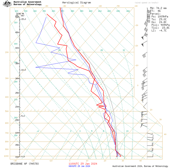
Image shows the relative humidity anomaly to 30th Jan 2024 (image via Ken Kato, EWN)
Meanwhile, on the 11 January, Sydney Observatory Hill registered a dew point of 26.7ºC, the highest since records began, although the extreme humidity has not been as persistent further south as compared to Queensland and northeast NSW overall.
The remnants of Ex-Tropical Cyclone Kirrily can explain the most recent extreme levels of humidity, as the system gradually moved into western QLD and weakened, whilst injecting moisture into a trough which caused the recent widespread heavy rain across the state. As these systems move away today (Ex-TC Kirrily will continue to move north), humidity levels will finally drop due to a burst of southeasterly winds, but even more notably from Thursday as a cold front brings a drier airmass across large parts of the country.
However, unusually high levels of moisture have been persisting for some time, even before Kirrily formed. So why has humidity been so high, particularly in an El Nino year?
A few factors are thought to have been behind this.
Firstly, sea surface temperatures around Australia have been unusually high. The warmer the air, the more moisture it can hold, so due to persistent onshore winds blowing off these warm waters, the humidity has been higher than normal.
Secondly, there has been a lack of cold fronts crossing the country this summer, allowing these persistent onshore winds to continue and allow moisture levels to build up, without moisture getting 'flushed' out by these cold fronts. This is also behind the lack of hot days across the nation's southeast this summer, as strong cold fronts typically drag hot air from the interior ahead of them in northerly winds.
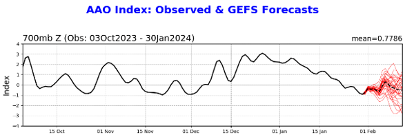
AAO Index from 3 October, showing positive values over summer
The scarcity of cold fronts can be attributed to an extended positive phase of the Southern Annular Mode (SAM), which refers to the north-south movement of robust westerly winds in the mid and high latitudes of the Southern Hemisphere. During a positive phase of the SAM, cold fronts tend to remain further south than usual. While this pattern is more commonly observed during La Nina years, it is quite atypical for El Nino years, which is the current climatic condition we are experiencing. Interestingly, there is a hypothesis suggesting that the eruption of Hunga Tonga-Hunga Ha'apai in 2022 injected a significant amount of water vapor into the stratosphere, resulting in a stronger polar vortex and a contraction of cold fronts towards the south, ultimately leading to the heightened positive SAM.
Although the relief from humidity is expected to persist for several days, there are indications that it may make a comeback early to mid next week as the remnants of Ex-TC Kirrily once again drift south. However, fortunately, this surge of humidity appears to be considerably shorter in duration compared to the prolonged period of humidity experienced throughout much of January.
Recent Articles
The Australian Tropical Cyclone season officially begins today
Australia’s Tropical Cyclone season has officially begun, running all the way through until April...
Understanding Cyclone Kirrily: What You Need to Know
As the tropical low in the Coral Sea intensifies, it's crucial for residents in eastern Queensland...