Thunderstorms return to South Eastern Queensland
The afternoon of Thursday 28 September will see thunderstorm activity return to South East...
Residents of northeast Victoria, southern and central NSW, including the ACT, should be prepared as storms may become severe on Tuesday. These storms may bring the risk of localised heavy rainfall, damaging winds, and hail, with sizes ranging from small to medium (2-4cm). However, the likelihood of experiencing a widespread severe storm outbreak is considered minimal.
An upper trough and a southeasterly change will trigger scattered showers and storms across northeast VIC, southern, and central NSW, including the ACT. Conditions are favourable for hail, which will mainly be small, but some localised storms could produce hail up to the size of golf balls if they intensify. Damaging wind gusts and locally heavy rainfall are also possible, especially along the eastern ranges where moisture levels are slightly higher.
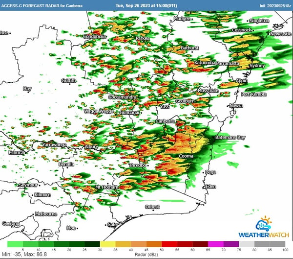 ACCESS C forecast radar for Tuesday afternoon. Image via WeatherWatch MetCentre.
On Wednesday, the upper trough is expected to move away, which will weaken the instability in the atmosphere. However, due to the presence of a trough and a southeasterly change, isolated thunderstorms are still likely to occur, focusing on the central and northeast NSW ranges. Some patchy thunderstorm activity is also possible over the central and northern inland parts of the state, although storms will be high based and are expected to contain little, if any, rain. Localised damaging winds are possible in storms, and one or two storms may contain hail on the NSW ranges.
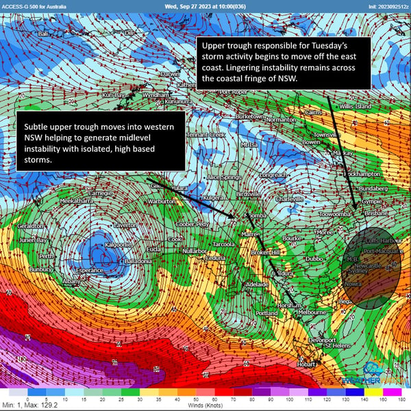 ACCESS G 500mb winds for Wednesday. Image via WeatherWatch MetCentre.
Residents in the affected areas are advised to stay alert and be prepared for potential severe weather conditions. Early Warning Network offers a variety of forecasting and warning technologies to assist in mitigating the risk posed by severe weather events. Customised wind and thunderstorm alerts give you timely information about locations in the path of storms before they are impacted, and our hail defence services are the leading hail forecasting and alerting products in Australia, protecting assets and people from damaging hailstorms.
If you would like to talk with our team about how these and other products can help you prepare for severe weather and hazards, chat to our team today.
The afternoon of Thursday 28 September will see thunderstorm activity return to South East...
Yesterday afternoon, severe thunderstorms moved across South-East Queensland, leaving widespread...