More Frosty Conditions to hit NSW, Queensland, Victoria and Tasmania
Much of southeast Australia is bracing for a significant cold outbreak as a polar blast sweeps...
Severe thunderstorms are affecting Victoria, the New South Wales (including the ACT) and Tasmania today causing damaging winds, heavy rainfall and localised large hail, with central NSW in the firing line tomorrow.
A trough and cold front as well as high levels of instability and strong wind shear are combining to generate prime conditions for severe thunderstorms across the region. Today, VIC and TAS are in the firing line with severe thunderstorms sweeping across the states from the late morning. Due to the linear nature of the wind shear, thunderstorms have predominantly been forming in lines and have been moving quickly with the severe weather being 'short and sharp'. However, the impacts have been felt across wide areas already including in and around Melbourne.
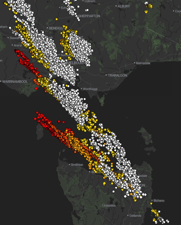
Over 65,000 lightning strikes were recorded across Victoria & Tasmania during a 4-hour period today (image via EWN)
Winds have battered Victoria, with gusts of up to 130km/h recorded at Mount Gellibrand and 122km/h at Avalon Airport near Geelong. Other notable gusts include 102km/h at Point Wilson, 98km/h at Mount William, and 85km/h at Sheoks. In addition, Melbourne Airport experienced gusts of 102km/h, Fawkener Beacon recorded gusts of 115km/h, and St Kilda had gusts of 106km/h.
 Storms approaching Pakenham today at 3.30pm (image by Steven English, via Severe Weather Victoria)
Hail has also been reported although generally localised, with hail to 2-2.5cm reported at Mordialloc and Mentone, and 2-3cm at Kilmore north of Melbourne. Heavy rainfall and small hail has been reported on the NSW central and southern ranges and around the ACT, and isolated patches of hail through northern Tasmania.
For the remainder of the afternoon, thunderstorms will continue tracking east, focusing on northeast TAS and eastern and northern VIC, and pushing into southern NSW later this afternoon and evening.
Tomorrow, the severe threat will shift to central NSW. Wind shear will weaken a little compared to today, however will still be strong enough to generate severe thunderstorms particularly due to the arrival of a southeasterly change pushing up the coas during the afternoon.
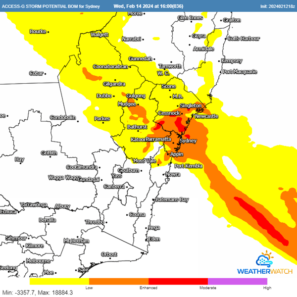
As the southeasterly change arrives, thunderstorms in the Sydney area may be limited to the western and northern parts, but the risk of severe weather will increase over the Central Tablelands and Hunter Valley. These thunderstorms bring with them the potential for damaging winds, large hail, and heavy rainfall.
On Thursday, instability will shift into northern inland NSW and western QLD. However, wind shear will weaken substantially, making severe thunderstorms unlikely. Although the risk of localised heavy rainfall remains, the likelihood of severe weather decreases significantly.
Many councils work directly with the Early Warning Network to keep their residents safe with timely, localised alerts and updates. If you want to know how our products can keep your assets and people safe, contact our team today.
Much of southeast Australia is bracing for a significant cold outbreak as a polar blast sweeps...
The afternoon of Thursday 28 September will see thunderstorm activity return to South East...
After knocking out power and damaging homes across Adelaide last night, a complex low pressure...