Friday May 26th 2023 produced an unusual late season hail event across the Hunter region of NSW, where large (3-5cm) to locally giant hail (5-6cm) was reported, making this some of the largest hail ever recorded in Australia during May.
Whilst most public forecasts weren't mentioning hail to this size on this day, hail (albeit small) was mentioned in Early Warning Network’s morning forecasts, in comparison to the Bureau of Meteorology’s forecast, which primarily mentioned the threat for offshore storms.
EWN morning forecast on Friday 26 May 2023 - risk of small hail was mentioned in the Hunter district
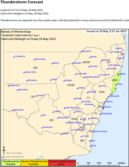 Bureau of Meteorology morning thunderstorm forecast on Friday 26 May 2023 -
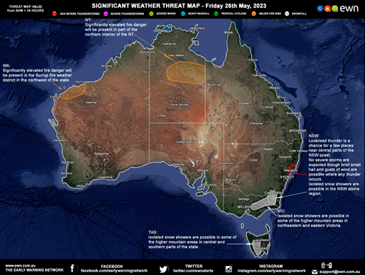
no mention of hail and thunderstorms in the areas most significantly affected, with the only mention of storms on land in the Mid North Coast
So, what caused these unexpected hailstorms?
The 6am Sydney Airport weather balloon sounding exhibited strong wind shear and significant atmospheric instability (associated with a passing upper trough), with very cool temperatures in the mid to upper levels of the atmosphere (-22 to -24°C). Despite this, a lack of moisture in the lowest 1-2km of the atmosphere was expected to keep storm initiation at bay.
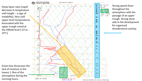 Bureau of Meteorology morning sounding for Sydney Airport
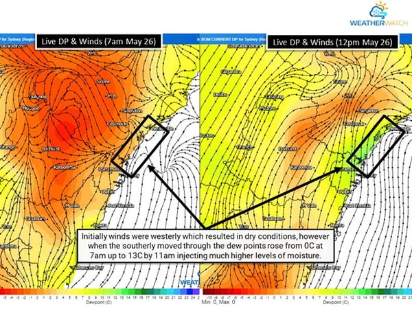
Despite this lack of low-level moisture, a southerly change was set to sweep up the NSW coastline during the day. During the warmer months, these are notorious for an injection of low-level moisture and low-level wind shear, commonly known as a triple point (three areas of wind that converge generating enhanced lift. In this case NE - NW – S winds).
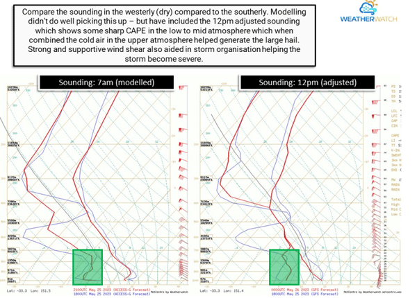 Morning 7am sounding compared to a modified 12pm sounding. Note the increase in low-level moisture from 7am to 12pm. Source Weatherwatch
 Source Weatherwatch
This rapid injection of moisture quickly saw thunderstorms develop along the coastal fringe of the Hunter region. With this moisture increase came an increase in instability, associated with very cold upper-level temperatures. The Dew Point (a measure of moisture in degrees Celsius) increased as the southerly changed moved through from 0C at 7am to 13C by 11am, which in turn helps to generate stronger instability, otherwise known as Convective Available Potential Energy (or CAPE and measured by joules per kilogram). This value increased from zero to more than 1000j/kg by 12pm in conjunction with the southerly and increased moisture.
At 11:09am, EWN sent off its first large hail alert to our customers warning them of the potential threat. 2.7cm sized hail was detected, which is considered large hail by the Bureau of Meteorology (over 2cm is considered as large and should be warned for), however the Bureau of Meteorology had not issued a warning.
By now, this storm was maturing and continued to intensify, with each hail alert seeing a steady increase in hail size. EWN continued to send off hail alerts, with alerts sent at 11:18am, 11:42am, 11:46am as reports of large hail began to filter in. It took until 11:51am for the Bureau of Meteorology to issue a severe thunderstorm warning for large hail - 42minutes after EWN detected and issued the first threat for large hail.
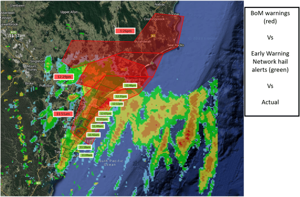
Comparison of issue time of BoM warnings and EWN hail alerts. Note the earlier issuance and more targeted spatial extent of the EWN hail alerts.
By 12:09pm, hail markers were showing 4.5-4.6cm hail within these severe thunderstorms, on the threshold of becoming giant hail (5cm and up is giant hail via Bureau of Meteorology’s severe thunderstorm warning criteria). As these images below show, the EWN hail markers accurately showcased this, with 3-5.5cm hail reported from these thunderstorms around the Jewells and Bennetts Green region of the Hunter.
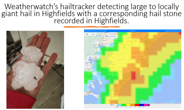
Weatherwatch's Hail Tracker (used by EWN to issue hail alerts) at 12:05pm. A 4cm hail marker is present in the Hunter, matching the reports of large hail observed.
Explore EWN's Hail Services or contact us for more information.
Recent Articles
Thunderstorms return to South Eastern Queensland
The afternoon of Thursday 28 September will see thunderstorm activity return to South East...
Australia’s Summer of Extremes: A Season of Severe Storms, Hail, and Cyclones
As summer comes to an end, we reflect on the major weather events that shaped Australia over the...