Thunderstorms return to South Eastern Queensland
The afternoon of Thursday 28 September will see thunderstorm activity return to South East...
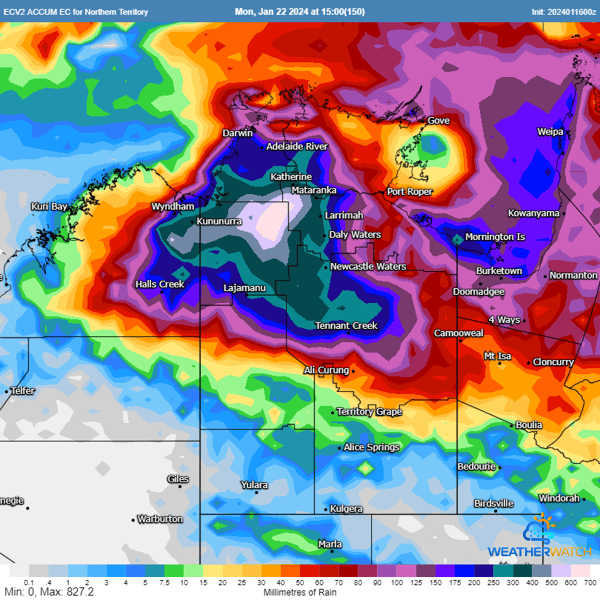
A slow-moving tropical low is producing significant amounts of rainfall over northern parts of the Northern Territory, with accumulated totals of 600-800mm, and localised higher falls possible in some areas. The risk of widespread major flooding and potential isolation of some communities is a serious concern.
In the past 24 hours, the low, which is currently hovering over the southern end of the Top End, has already caused heavy rainfall in several locations. Noonamah has received 113mm, Adelaide River 144mm, Daly River 116mm, and Bradshaw 125mm. Such instances highlight the unpredictability and intensity of these weather systems. Our real-time severe weather alerts and advanced forecasting tools can be indispensable in such situations, providing timely updates and allowing for necessary precautions to be taken.
While tropical lows are common during the wet season, the distinct slow-moving nature of this system makes it particularly noteworthy. It's expected to remain quasi-stationary until at least Saturday, leading to very heavy rain over the same area for multiple days.
24 hr Accumulated Rainfall via WeatherWatch
The Bureau of Meteorology has issued a severe weather warning for heavy rainfall that may lead to flash flooding, with scattered six-hourly rainfall totals between 100-160mm likely. Damaging wind gusts to 90km/h are also possible in these thunderstorms, as well as in monsoon squalls.
The system is expected to shift westward into the Western Australia Kimberley district from Sunday, bringing with it the risk of heavy rainfall and damaging winds. The system may continue to track west or southwest through next week, posing continued risks. Whether it stays over land or moves over open waters with the potential to develop into a tropical cyclone, our advanced forecasts, tracking and alert systems will keep you informed and prepared.
Our products are designed to give you detailed and accurate information, helping you to plan and respond effectively.
Stay safe and stay informed with our comprehensive weather-related services, designed to provide peace of mind and effective solutions during such unpredictable weather events.
The afternoon of Thursday 28 September will see thunderstorm activity return to South East...
Severe thunderstorms lashed Victoria and New South Wales yesterday in one of the most intense...
As the tropical low in the Coral Sea intensifies, it's crucial for residents in eastern Queensland...