Showers, storms and cooler weather is on the way for many parts of New South Wales and Queensland over the next few days, bringing relief after a prolonged spell of hot and humid weather across the states.
The start of summer has been a stinker, with temperatures up to four degrees above average across many parts of NSW and QLD. For Sydney, it was the hottest start to summer in more than 160 years of records.
Widespread rainfall throughout November has meant the hot weather hasn't resulted in widespread destructive bushfires as seen in October, however numerous bushfires are still burning, particularly over central and northern parts of NSW. A particularly large fire is currently burning in the Pilliga forest between Narrabri and Coonabarabran, which has burnt out more than 110000 hectares, the largest fire in the area since at least 1997.
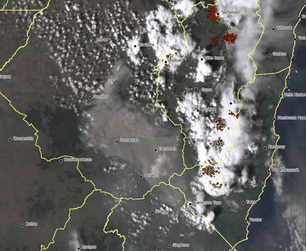
Thankfully, widespread rain and storms will sweep across NSW and southern and central QLD over the next few days bringing relief. The storms will be triggered by a low pressure trough, that is being fed by moisture from the remnants of Ex-Tropical Cyclone Jasper which has brought devastating floods to far north QLD. Rainfall totals will be nowhere near as high, with widespread falls of 25-50mm expected from central NSW to central QLD, particularly across the tablelands and slopes. Under heavier thunderstorms, falls of 100-150mm are possible, although these will be relatively localised/hit and miss.
-1.png?width=1000&height=337&name=image%20(10)-1.png)
Severe thunderstorms are also possible, particularly today over NSW (southern to northern parts of the state) when wind shear will be at its strongest. Damaging winds and heavy rainfall are the highest threats, however localised large hail is also possible in thunderstorms.
In the wake of the system, much cooler conditions are likely. For example, Sydney reached 35 degrees on Tuesday, but will reach only 23 degrees on Wednesday. Narrabri has seen temperatures in the mid to high 30s, even low 40s the last few days, but will cool to the mid 20s on Wednesday and Thursday.
Recent Articles
Low to bring cold weather to southeastern Australia; bushfire weather to NSW
A complex low pressure system will bring a burst of strong winds, heavy rainfall and thunderstorms...
Heavy rainfall and flooding likely for Sydney to the South Coast this weekend
It’s Groundhog Day for NSW.