Understanding Cyclone Kirrily: What You Need to Know
As the tropical low in the Coral Sea intensifies, it's crucial for residents in eastern Queensland...
It’s Groundhog Day for NSW.
Another bout of heavy rainfall is on the verge of impacting the region, with coastal areas again in the firing line. A coastal trough will deepen Saturday into Sunday in response to an upper low drifting across the state. It’s almost like we’ve heard this all before.
This pattern has been ongoing for several weeks, with a series of blocking highs situated to the south, shunting any frontal system well south of Australia. These persistent and continued blocking highs pump moisture-laden air onto the coastal fringe and well inland. All that’s left is a trigger to set it off.
Enter the upper low.
A similar scenario is about to unfold for the third time in four weeks.
 Current water vapour satellite image. An upper low generates a large cloud and rain band through the eastern interior of Australia.
Areas of heavy rainfall will develop Saturday, with a relatively focused region likely from Sydney down onto the South Coast forecast district. Over the next 48-72 hours, accumulated 100-200mm totals will fall for numerous towns, potentially higher for some locations. In light of recent events, soils across the region are wet and will respond quickly to heavy rainfall.
This afternoon, the Bureau of Meteorology issued a flood watch for the Hawkesbury, Lower Nepean, Upper Coxs River, Colo River, St Georges Basin, Clyde River, Moruya, and Deua Rivers. While this flood watch is only for minor flooding, further flooding cannot be ruled out, particularly in light of the recent rainfall upgrades from a couple of forecast models. Significant flash flooding will also be of concern, with creeks expected to respond rapidly to heavy rainfall.
A small low is forecast develop off the coast of Sydney by Sunday, which may play a brief but potentially significant role in increasing rainfall for parts of the Wollongong and South Coast. Fresh and gusty southeast to southwesterly winds will also strengthen as this low deepens late Sunday into Monday before rapidly moving off into the Tasman Sea.
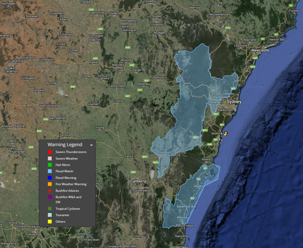
Flood watches were issued by the Bureau of Meteorology this afternoon.
Sydney is on an eleven-day run with rainfall exceeding at least 1mm. Sydney's all-time daily rainfall streak sits at sixteen. With at least another three days of rain set to fall and showers likely to continue into next week - could this run be broken?
This afternoon, a severe weather warning was issued for heavy rainfall, leading to flash flooding and riverine flooding.
As the tropical low in the Coral Sea intensifies, it's crucial for residents in eastern Queensland...
The New South Wales east coast is bracing for an extraordinary weather system this week, as...
Tropical Cyclone Alfred has now turned towards land, intensifying as it approaches the southeast...