Weather News Archive 2018 May
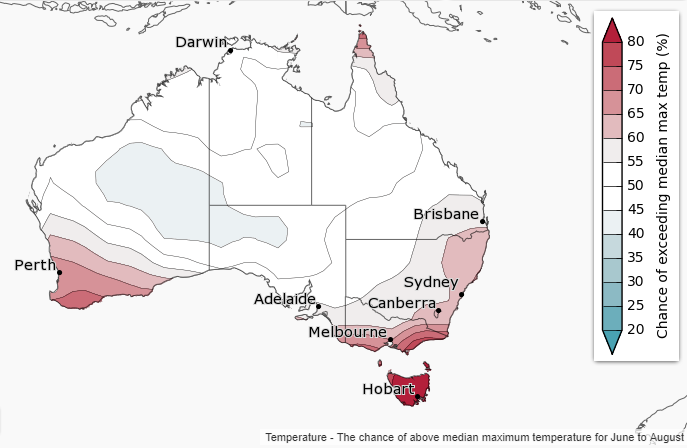
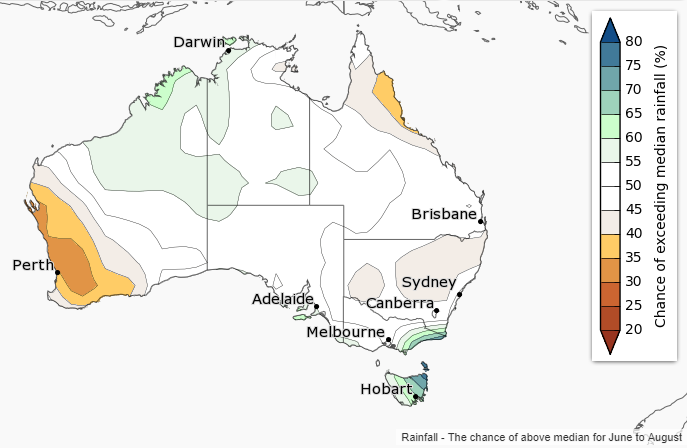
Images: (a) Temperature outlook for winter across Australia (Source: Bureau of Meteorology) (b)...
The Bureau of Meteorology released its winter weather outlook yesterday, revealing a mixed bag for the country during the next few months.
The nation's main climate drivers - the El Nino Southern Oscillation and Indian Ocean Dipole, are both currently neutral, meaning there is no strong indication towards a wetter or drier (or warmer or cooler) winter for most of the country.
However, warm temperatures over the Tasman Sea may lead to enhanced rainfall over eastern Victoria and eastern Tasmania, whilst rainfall is expected to be lower over southwest Western Australia due to weaker than average westerly winds.
Meanwhile, temperatures are expected to be warmer than average across southwest and southeastern Australia due to high pressure expected to lie further south than normal, leading to reduced frontal activity. However, cooler than average night time temperatures are more likely in northern Queensland.
With the background warming trend across the country, those in neutral areas are more likely to see temperatures warmer than average rather than cooler than average.
Images: Temperature and rainfall outlooks for the June-August Period (Australia Bureau of Meteorology)
Images: (a) Temperature outlook for winter across Australia (Source: Bureau of Meteorology) (b)...
On Tuesday, the Bureau of Meteorology issued an El Niño alert, with a 70% chance of El Niño later...
With the Japanese and the USA meteorological agencies recently declaring a La Nina event, Australia...