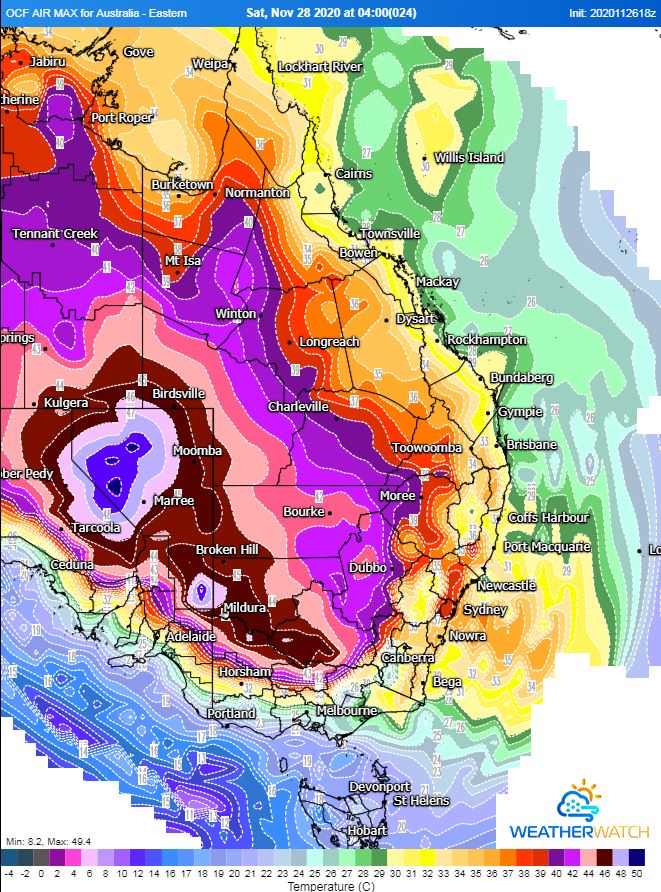
Image 1: Operational Consensus Forecast max air temperature for Saturday 28/11/2020. Image via WeatherWatch MetCentre.
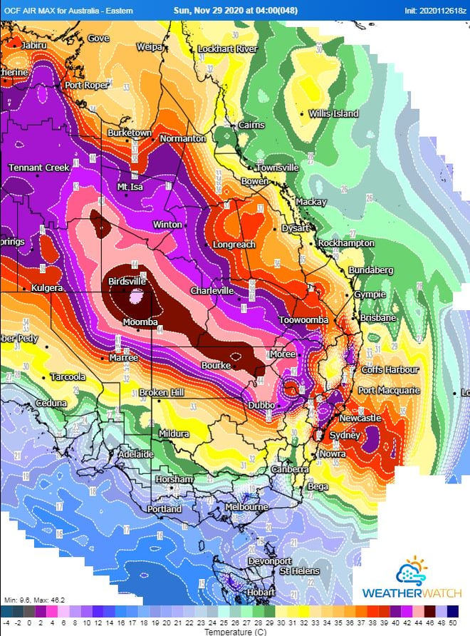
Image 2: Operational Consensus Forecast max air temperature for Sunday 29/11/2020. Image via WeatherWatch MetCentre.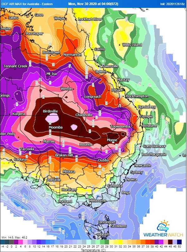
Image 3: Operational Consensus Forecast max air temperature for Monday 30/11/2020. Image via WeatherWatch MetCentre.
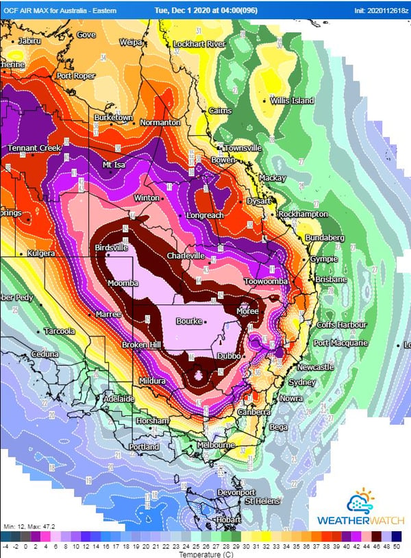
Image 4: Operational Consensus Forecast max air temperature for Tuesday 1/11/2020. Image via WeatherWatch MetCentre.
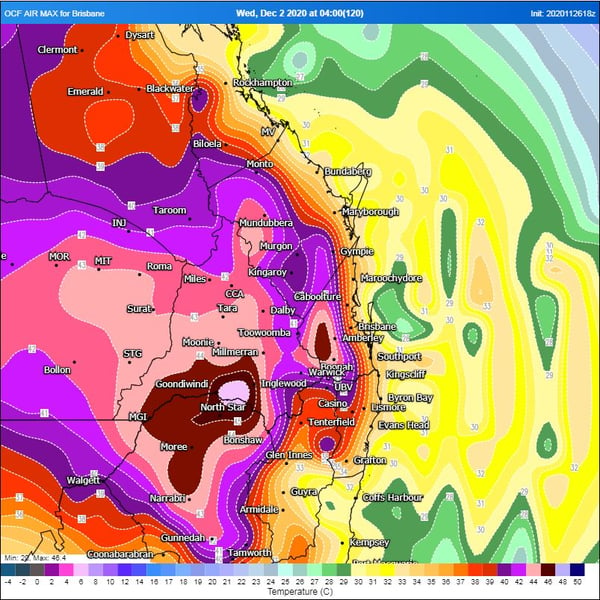
Image 5: Operational Consensus Forecast max air temperature for Wednesday 2/12/2020. Image via WeatherWatch MetCentre.
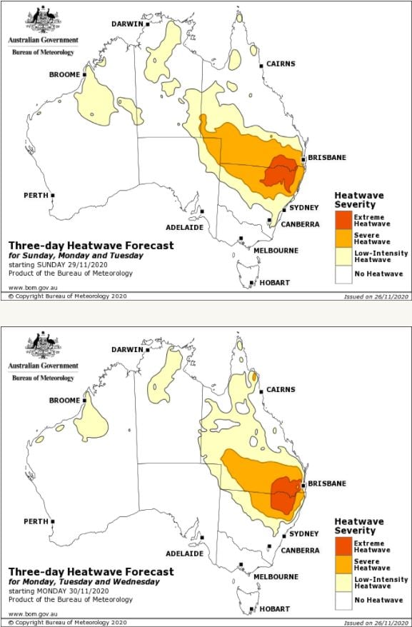
Image 6: Bureau of Meteorology Heatwave maps. Sunday-Tuesday, Monday-Wednesday.
Southern and Eastern Australia is set to sizzle!
Friday 27th November 2020
Near-record breaking temperatures are expected across a large portion of the country over the next several days as an intense heatwave develops for Southern and Eastern Australia.
For weeks, persistent upper ridging has allowed intense heat to build across the north of the country with dry conditions continuing for many locations.
A low pressure trough traversing the country will drag this heat south into central and eastern parts of the nation, with record to near-record November temperatures likely.
Many locations across inland South Australia, New South Wales, Queensland, Northern Victoria and parts of the Northern Territory will see temperature soar into the 40's. The Operational Consensus Forecast even has a small area of 50°C being reached in Central South Australia. Whilst this isn't likely, mid to high 40's is expected. Adelaide is expecting a top of 40°C today, 38°C on Saturday before a cool change move through the state.
Temperatures will soar across the capital cities, with Brisbane expecting 33°C Sunday, 32°C Monday, 33°C, Tuesday before a scorcher on Wednesday topping out at 37°C. Western parts of South East QLD may seen temperatures into the low 40's, with parts of the Darling Downs into the mid 40's.
Sydney will also feel the extreme heat this weekend. On Friday, a pleasant top of 26°C is expected, increasing to 36°C on Saturday increasing to 38°C on Sunday.
Relief is on the way, as a gusty southerly change sweeps up the coast on Monday for NSW before reaching southern QLD on Wednesday. This southerly change will drop temperatures by up to 13°C for some locations.
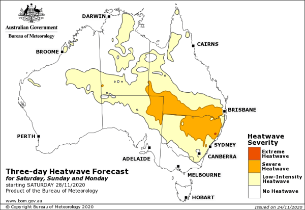
Image 1: Heatwave forecast from Saturday 28th November to Monday 30th November across Australia, sourced from Bureau of Meteorology
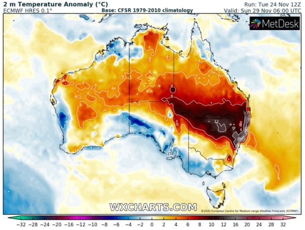
Image 2: Temperature anomaly for Sunday 29th November, 2020 (Source: wxcharts.com)
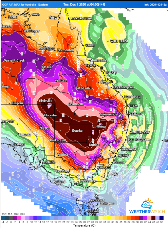
Image 3: OCF Forecast Maximum temperatures for Tuesday 1st December, 2020 (Source: Weatherwatch Metcentre)
Intense November heatwave spreading into NSW and QLD
Wednesday 25th November 2020
An intense November heatwave is beginning to spread into western parts of New South Wales and Queensland today, and is expected to persist into early December as a slow moving and very hot airmass pools over the region.
A very dry November across large parts of Australia (despite La Nina) due to persistent upper level ridging has allowed the very hot airmass to build across the nation over the last few weeks, originally developing over the nation's northwest.
A trough of low pressure is bringing this airmass to the east of the country now, where it is expected to linger for at least the next week. Temperatures are expected to be more typical of a mid summer heatwave rather than late spring, with the mercury expected to soar into the mid to high 40s across some inland areas over consecutive days, challenging the record 2009 November heatwave.
Western parts of NSW and QLD are expected to scorch, with towns such as Bourke, Thargomindah, Birdsville, Wilcannia, Walgett and White Cliffs likely to see at least five to six consecutive days of 40 degree plus temperatures, and some locations possibly longer. Bourke may reach up to 46 degrees on Sunday and Tuesday, whilst Birdsville is expected to see 46-47 degree heat between Friday 27th November and Tuesday 1st December. Whilst some may think these temperatures over inland areas are typical, for this time of year they are very unusual (and generally occur in January and February), with only November 2009 and November 2014 seeing similar heat for this time of year.
The slopes, ranges and eastern plains (Dubbo, Moree, Tamworth, Charleville, Inglewood etc) will feel the worst of the heat a little later, with the hottest airmass affecting these regions from the weekend and into early December, with temperatures reaching into the mid-high 30s and low-to mid 40s (depending on elevation).
Further east will be spared the worst heat, with weak southerly changes also preventing heat from persisting over too many consecutive days. Sydney will see its hottest days this weekend reaching into the mid 30s in the city, and up to 42 degrees in the west over both days, with a secondary burst of heat on the first day of December. Brisbane (and northeast NSW and southeast QLD) will see their hottest days between Sunday 29th and Wednesday 2nd, before a cooler change. Seabreezes will moderate temperatures on the coast (limiting to mid 30s), however inland areas (such as Ipswich) will see consecutive days in the high 30s or low 40s.
The hot airmass is expected to break down over the east of the country within the first week of December due to a cold front and an increase of moisture, showers and storms.
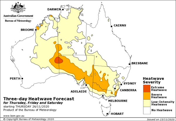
Image 1: Heatwave forecast from Thursday to Saturday across Australia, sourced from Bureau of Meteorology
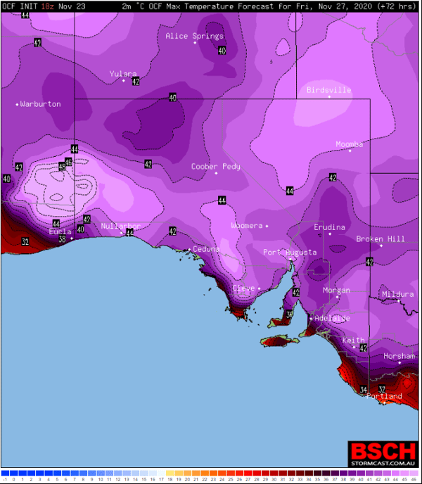
Image 2: OCF Forecast Maximum temperatures for Friday 27th November, 2020 (Source: BSCH Stormcast)
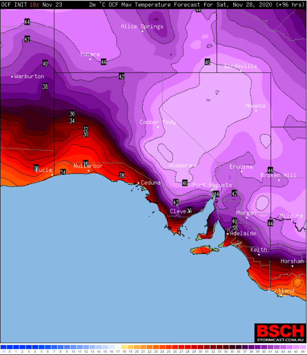
Image 3: OCF Forecast Maximum temperatures for Saturday 28th November, 2020 (Source: BSCH Stormcast)
Severe heatwave to grip South Australia
Tuesday 24th November 2020
An intense band of heat is set to grip southeastern Australia to finish off November, with South Australia likely to feel the brunt of it as temperatures soar into the mid 40s in some areas.
November has been unusually hot across large parts of the country as persistent upper level ridging keep the continent cloud free and cold fronts south of the mainland. This has allowed heat to build gradually over the last few weeks, with no cold fronts to 'flush it out' or cloud to reduce its intensity, with the airmass now becoming extremely hot.
The heatwave will begin tomorrow across the state, particularly over western areas where temperatures will rise into the mid to high 30s (Nullarbor 39 degrees, Ceduna 36 degrees, Port Augusta 36 degrees), with Adelaide reaching 33 degrees.
A weak southerly change will keep coastal areas cooler on Thursday (generally in the low to mid 30s), however it will get hotter over inland parts of the state (Coober Pedy 39 degrees, Oodnadatta & Port Augusta 39 degrees, Hawker 38 degrees).
The heatwave will reach its peak on Friday over western and coastal areas, and Saturday for the remainder of the state, when November records are expected to be challenged. Adelaide and other parts of the southeast (away from the coast) can expect to see both days in the 40s, with Friday expected to be a little hotter at this stage as a cooler change begins to push into western and coastal areas on Saturday (and the timing of this change will greatly affect how hot it will get).
Hawker can expect to reach 43 degrees on Saturday, Woomera 45-46 degrees and Port Augusta 46-47 degrees (challenging their November records), Coober Pedy 45 degrees and Oodnadatta 46 degrees. A hot night is also expected to separate both Friday and Saturday, with minimum temperatures staying in the mid to high 20s for many areas.
A cooler change will push through from the west and south on Saturday, and reach the northeast of the state on Sunday, although maximum temperatures will still remain in the mid to high 30s (and even low 40s) in these areas as the hot airmass lingers.
Fire danger is not expected to be extreme on most days due to light winds, however the cooler change on Saturday which may be associated with gusts to 80km/h is likely to increase fire danger. Fire danger may also remain elevated into Sunday despite a cooler airmass as southerly winds remain fresh to strong and gusty.
A stronger cool change will push through later on Monday or Tuesday, bringing much needed relief.
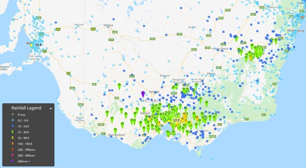
Image 1: Rainfall totals in the 24 hours to 9am today across Victoria and southern NSW, showing a peak across southern Victoria and the ACT
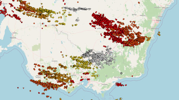
Image 2: Lightning recorded across southeast Australia between 8pm Sunday 22 November and 11am Monday 23 November, 2020
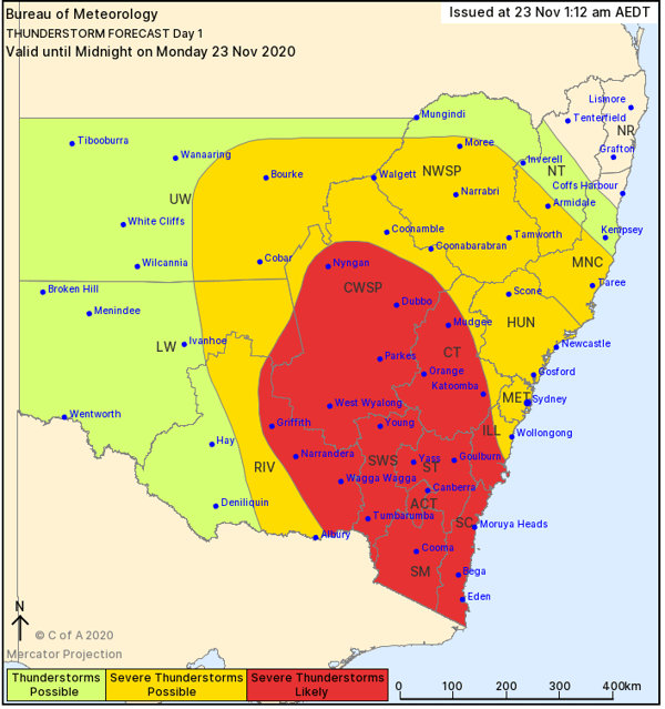
Image 3: NSW Thunderstorm threat map for Monday 23 November (Source: Bureau of Meteorology)
Heavy rain drenches Victoria and the ACT as widespread rain and storms hit southeast Australia
Monday 23rd November 2020
Rain and thunderstorms swept across southeastern Australia last night, producing widespread rain and a spectacular lightning show across Victoria, southern New South Wales and the ACT.
A broad trough fed off humid onshore winds as it moved into the east of the nation, causing widespread rain across the nation's southeast, with some of these containing heavy rain and strong winds.
Whilst not every part of Victoria saw heavy rain, it was still impressively widespread with almost all of the state recording at least some rainfall in the 24 hours to 9am today. The rain was heaviest in the south of the state, with the Melbourne area and Central district particularly wet where there were widespread falls of 20-40mm, and isolated heavier totals.
Moorabbin Airport (southeast of Melbourne city) had its wettest November day on record and wettest day since February 2011, registering 63.2mm to 9am today. Warburton (to the east of the city) had 64mm to 9am today, the wettest November day since 1978. The city itself had 30.2mm, which wasn't statistically significant, but was the city's first decent rain in a month.
Whilst the interior will remain unusually hot throughout the entire end of the month, notably hot days are likely to affect SA tomorrow (with significant fire danger), before an extremely hot airmass develops later this month over northern and central WA and moves into southeast WA and SA on the final days of the month, with potential for maximum temperatures in the mid to high 40s.
Thunderstorms over the ACT last night produced a spectacular lightning show and dropped heavy falls over Canberra and much of the territory (except the south). Falls of 20-40mm were again commonplace, including Canberra airport that recorded 30mm to 9am, and another 12.4mm since 9am as another band of storms moved through.
Thunderstorms continued this morning over Victoria's east and pushed into southern NSW and the ACT, causing further heavy rain (43mm at Basin Creek and 34mm at Mount Elizabeth) as well as strong winds in some places. Wind gusts reached 107km/h at Yarrawonga this morning, 87km/h at Albury, 95km/h at Cabramurra and 93km/h at Mount Ginini as the line moved through.
For the remainder of the day, the line of storms will progress east across the state, with most areas except the far west, northwest and northeast likely to see activity. Damaging winds and locally heavy falls remain the highest threat. Thunderstorms will contract into northeast NSW and southeast QLD tomorrow where the threat of isolated severe activity remains.
Image 1: Bureau of Meteorology fire danger ratings next 4 days.
Western Australia endures 20 straight Fire Weather Warning days, with no let up in sight
Sunday 22nd November 2020
In a stark contrast to Eastern Australia, Western Australia is in the middle of an unwanted hot streak, with today (Sunday the 22nd of November) the 20th consecutive day with severe fire danger or higher across the state.
During early Spring, a hot airmass steadily built up across Northern WA, with gusty easterly winds elevating fire dangers across the north. As frontal systems develop across the west, this hot air began to be dragged south across the Interior, Pilbara, Gascoyne and Eucla regions of WA.
Out of these 20 days, there has been 4 days with catastrophic conditions, and over half a dozen featuring extreme conditions with at least severe conditions on every day. Thankfully, this hasn?t translated to widespread destructive fires, as most regions are well away from populated locations with little to no vegetation to be burnt.
In mid-October, 15 consecutive fire weather warning days were issued for WA from the 7th to the 21st (inclusive). From October 1st to November 22nd, there have been 47 days with severe fire danger or higher out of a possible 53 days, with no let up in sight. This streak won?t end at 20, with severe fire danger to continue across the state over the coming days.
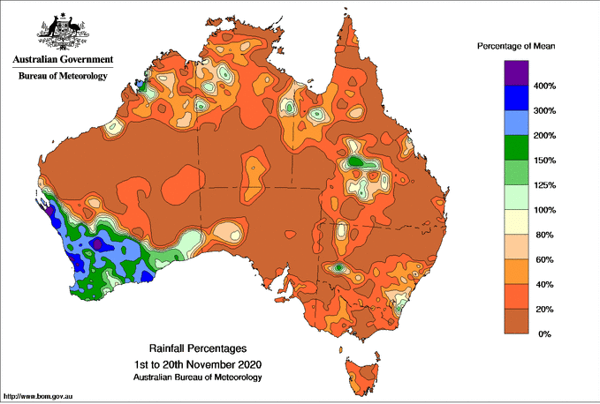
Image 1: Rainfall percentage for the month to date across Australia, showing the very dry conditions across most of the country (Source: Bureau of Meteorology)
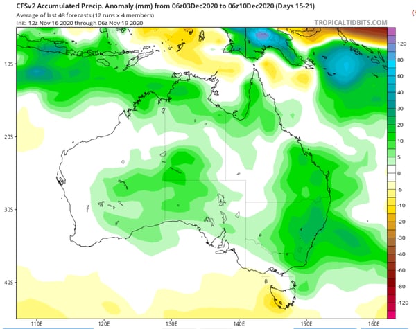
Image 2: CFS Weekly rainfall outlook, indicating a return to wetter than average conditions early to mid December (Source: Tropicaltidbits.com)
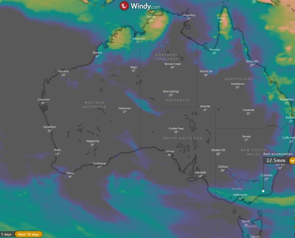
Image 3: Accumulated 10 day rainfall totals across Australia from the ECMWF model (Source: Windy.com)
Hot and dry end to November for most of Australia despite La Nina
Friday 20th November 2020
The last ten days of November are going to end on a hot and dry note for large parts of the country, with very dry and unusually hot conditions for many areas despite La Nina.
After a relatively cool first week of the month, temperatures have rapidly climbed and rain mostly vanished after a wet October for many areas. More than halfway through the month, most of the country hasn't even received 20% of its average monthly rainfall, excluding southwestern parts of Western Australia (where Perth is having its wettest November on record).
Temperatures have been well above average across most areas, particularly over the interior, Tasmania, parts of Victoria, South Australia, inland Queensland, inland New South Wales, the Northern Territory and northern and eastern Western Australia, with some locations including Alice Springs, Darwin and Hobart on track to record their warmest November on record.
Unfortunately, the remainder of the month is likely to see more of the same for many areas, with conditions remaining unusually hot and dry for November. The exception to this will be over parts of southeast Australia on Sunday and Monday (where 15-30mm could fall over parts of Victoria), mid to late next week over the east coast (mainly northeast NSW and eastern QLD), and the tropics where shower and storm activity is expected to increase.
Whilst the interior will remain unusually hot throughout the entire end of the month, notably hot days are likely to affect SA tomorrow (with significant fire danger), before an extremely hot airmass develops later this month over northern and central WA and moves into southeast WA and SA on the final days of the month, with potential for maximum temperatures in the mid to high 40s.
So why is it so hot and dry despite La Nina?? Whilst the La Nina continues to intensify and trade winds remain strong, this alone is not enough to produce rainfall. Persistant and strong upper level ridges over central and southeast Australia have been commonplace this month, causing all rainbearing systems to slip south. As a result, the moisture that has built up from the trade winds is not used as there is no 'trigger' to produce rain. However, these ridges haven't been affecting southwest Australia, which has seen very wet conditions for November due to frequent frontal systems in the first half of the month.
In all probability this 'ridgy' pattern will break down within a few weeks, with models suggesting a return to more typical La Nina conditions from early to mid December. This should also help reduce the amount of heat over the country as well.
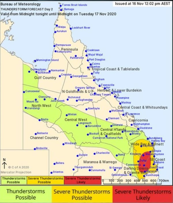
Image 1: Bureau of Meteorology storm forecast map. Valid Tuesday 17/11/2020.
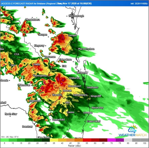
Image 2: High resolution ACCESS C forecast radar. Valid 4pm Tuesday 17/11/2020. Image via WeatherWatch MetCentre.
Thunderstorms to return to SE Queensland
Monday 16th November 2020
After a hot and muggy weekend, thunderstorms will return to South East Queensland on Tuesday afternoon before a cooler southerly change sweeps through the region during the late afternoon and evening.
An upper level disturbance will move through southern Queensland on Tuesday in combination with a surface trough. Whilst wind shear is considered marginal for organised storms, the injection of a modified southeasterly change moving up the coast will increase moisture and low-level wind shear to the region.
This increase in moisture and low-level shear (enhancing the overall bulk shear) will increase the threat for one or two organised storms to develop across SE QLD. Areas west of Brisbane are more likely to experience a severe storm on Tuesday afternoon, with a cooler, stable and capped airmass expected across coastal locations. Some areas along the coastal fringe may still experience localised shower and storm activity however these are not expected to be severe at this time.
Western regions of SE QLD and the eastern Darling Downs are expected to face the potential for a severe storm or two, with Boonah-Gatton-Esk-Kilcoy areas a higher risk. Damaging winds and large hail will be the primary threat with severe storms during the afternoon and evening however locally heavy falls cannot be ruled out.
The southerly change will drop temperatures by up to 5°C on Wednesday, with maximum temperatures in the late 20's to early 30's expected.
Image 1: EC predicted thunderstorm for QLD Friday afternoon. Image via windy.com
Image 2: EC predicted thunderstorm for NSW Friday afternoon. Image via windy.com

Image 3: EC predicted thunderstorm for NT Friday afternoon. Image via windy.com
A stormy Friday afternoon for eastern Australia
Friday 13th November 2020
Over the last 48 hours, thunderstorm activity has steadily progressed east with severe storms striking parts of South Australia, western Queensland, NSW, Victoria and the Northern Territory.
During Friday afternoon, a surface trough and upper trough will combine to produce widespread thunderstorms across eastern QLD and NSW, extending to the northwest into the Top End of the Northern Territory.
Severe thunderstorms are expected across central and eastern NSW later this afternoon, including the Sydney and Hunter regions with damaging winds, large hail and heavy rainfall that may lead to flash flooding. The first severe thunderstorm warning of the day was issued at 11:59am for parts of the Central Tablelands, North West Slopes and Plains, Central West Slopes and Plains and the Hunter region.
Further storm activity is expected across northern NSW, extending through southern, central and northern QLD throughout the afternoon with the potential for more severe storm activity. Damaging winds and heavy rain will be the primary threat across northern QLD and parts of the NT, with large hail also possible across southern QLD and northern NSW.
This activity will clear off the east coast this evening, with gusty westerly winds and warm-to-hot temperatures moving across QLD and NSW.
Storm activity will fire up across parts of the NT again on Saturday before increasing across central regions into Sunday. Locally damaging winds in the form of microbursts may develop, with the potential for locally heavy falls across inland parts of the Top End.
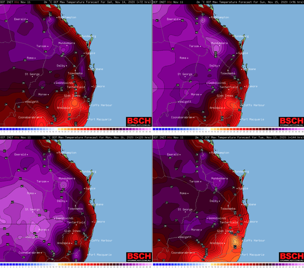
Image 1: OCF forecast maximum temperatures for Saturday (upper left panel),
Sunday (upper right panel), Monday (lower left panel) and Tuesday (lower right panel). Source: BSCH.com
Above average temperatures to spread across southern Queensland and New South Wales.
Wednesday 11th November 2020
In what's likely to be the first real multiday period of above average temperatures so far this Spring, a north to northwesterly flow will drag warm to hot air down over much of southern Queensland and northern New South Wales this weekend into early next week. Afternoon seabreezes are likely to moderate this heat along the coastal fringe but even there, an increase in temperatures is expected.
However widespread record breaking heat is currently not anticipated.
Maximum temperatures are expected to increase to the low 40s in parts of the southwestern and southern interior of Queensland as well as the northwestern and northern interior of New South Wales, the mid to high 30s at low inland elevations east of the Great Dividing Range and close to 30 degrees along the coastal fringe.
Warmer minimum temperatures are also expected during this time.
However there are some indications this heat may ease by the middle of next week as a cooler southeasterly wind change moves up the coast.
Warmer minimum temperatures are also expected during this time.
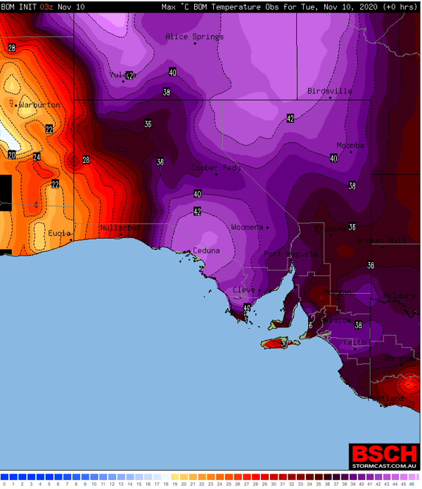
Image 1: Max temperature to 2:30pm Local Time 10th November 2020, showing the widespread heat across the state (Source: BSCH Stormcast)
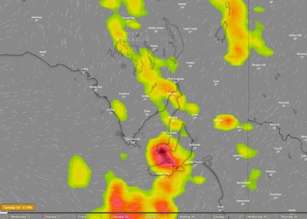
Image 2: Thunderstorm forecast at 11pm AEDT across SA, showing thunderstorms spreading across the state tonight and into tomorrow morning
South Australia bakes with thunderstorms set to hit the south
Tuesday 10th November 2020
Temperatures are soaring across South Australia today with large parts of the state pushing into the high 30s and 40s, with thunderstorms likely this afternoon and into Wednesday morning ahead of a cooler change.
After a very warm night with some places seeing minimum temperatures more than 16 degrees above average, the mercury has soared today with most parts seeing their hottest day so far this year. Most parts of the Adelaide region have reached the high 30s, whilst some northern and western parts of the state have pushed into the 40s (Ceduna 42.9 degrees, Tarcoola 42.1 degrees).
The heat combined with windy conditions are causing elevated fire danger, with Severe Fire Danger across the North West Pastoral, West Coast, Eastern Eyre Peninsula and Lower Eyre Peninsula, reaching Extreme over the Yorke Peninsula. After the recent rain, grass fires are the main threat.
Relief is on the way as a cooler southwesterly change spreads east, with western parts of the state already seeing sharp drops in temperature (Ceduna has fallen from 42.9 degrees at 1:39pm to 24.3 degrees by 2pm local time). Across southern parts of the state, thunderstorms have developed ahead of and with the change.
These thunderstorms are likely to contain little if any rainfall and be higher based, but may produce damaging wind gusts to 100km/h. Thunderstorms are likely to persist this afternoon and evening and into Wednesday morning (focusing on the state's southeast, including Adelaide), before spreading into Victoria and New South Wales by the early afternoon. Damaging winds will remain the main threat due to strong wind shear, however over the far southeast locally heavy rainfall also becomes a threat as the system encounters higher moisture levels.
Cooler conditions are likely in the wake of the change, before hotter conditions return over the weekend.
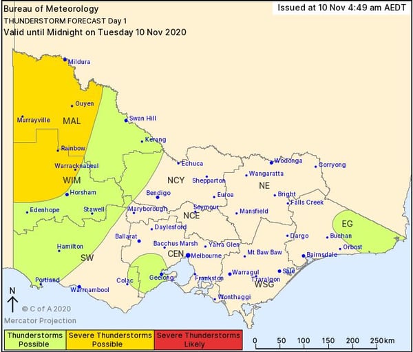
Image 1: Bureau of Meteorology day 1 thunderstorm outlook.
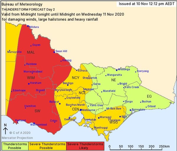
Image 2: Bureau of Meteorology day 2 thunderstorm outlook.
Severe storms on the way for Victoria
Tuesday 10th November 2020
After a lean start to the storm season, things are going to heat up over the next 48 hours across central and western Victoria as a strong low pressure system and cold front sweep across southeastern Australia.
During Tuesday afternoon, a few thunderstorms are expected to develop across far western parts of the state, with the threat of an isolated severe storm or two. High based thunderstorms are expected, with the potential for damaging winds in the form of microbursts.
On Wednesday, cloud and showery conditions are expected during the morning hours before substantial storm activity develops along the trailing cold front.
Numerous thunderstorms are expected to develop late Wednesday afternoon with strong wind shear favouring a few organised storms capable of producing damaging to locally destructive winds, large hail and the potential for heavy rain leading to flash flooding across western parts of Victoria.
This system will slowly move east into Thursday, with scattered showers expected to continue across central and southern parts of the state, as westerly winds wrap around the backside of the low pressure system over Tasmania.
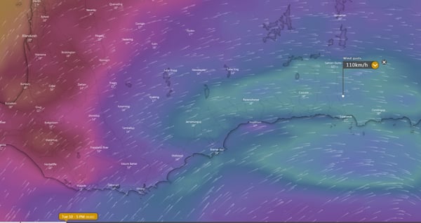
Image 1: Wind gust forecast for southern WA at 5pm AEDT (2pm local time), showing potential for wind gusts to reach 110km/h. (Source: Windy.com)
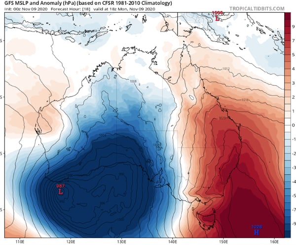
Image 2: Pressure anomaly demonstrating the unusually low pressure for this time of year across the region (Source: Tropicaltidbits.com)
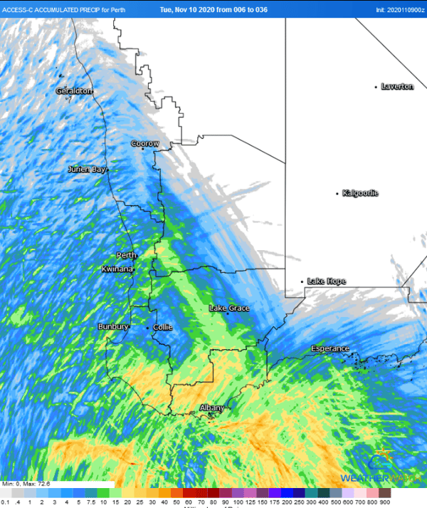
Image 3: Accumulated precipitation from the ACCESSC Model for the 30 hours from 2pm local time Monday 9th November
until 10pm local time Tuesday 10th November (Source: Weatherwatch Metcentre)
Low pressure system bringing showers, thunderstorms and strong winds to southern WA
Monday 9th November 2020
The effects of an unseasonably strong low pressure are being felt across the southwest of Western Australia today as showers, strong winds and thunderstorms hit the region, however for some areas the worst is yet to come as the low deepens and nears the southern coast tomorrow.
A band of showers swept onto the state's southwest this morning associated with a front (attached to the low), bringing some much needed rain to the region. Widespread totals of 5-15mm, however some areas saw isolated heavier falls in excess of 30mm. Jarrahwood recorded 32mm to 9am, its best rain since July and heaviest November fall since 1997.
A few isolated thunderstorms have also been observed with the system and remain a threat on the leading edge of the front today as it moves east. On the leading edge (in showers and thunderstorms), strong winds to 90km/h are possible, with a severe weather warning remaining in effect for people in South Coastal and parts of South West, South East Coastal and Great Southern districts.
This system is far more typical of winter than mid to late spring. The low is expected to deepen throughout the day and into Tuesday morning, before arcing north in response to a sharp high pressure ridge to the south of the low. This will cause a much stronger burst of winds along the southern WA coastline on Tuesday with the strongest gusts expected from Northcliffe to Israelite Bay, and possibly as far north as Salmon Gums. Widespread wind gusts of 70-90km/h are likely, however in some places (such as Ravensthorpe and Esperance) gusts may reach up to 100-110km/h. These winds have potential to cause damage to homes and property, bringing down trees and powerlines.
Along the coastal fringe (southwest of Israelite Bay) a few showers and brief thunderstorms are also possible, which bring potential for wind squalls independent of the low. An upper level cold airmass will also bring the risk of small hail in any showers or storms.
From Wednesday, the low will clear WA as it moves into South Australia, Victoria, New South Wales and Tasmania, where strong winds and severe thunderstorms are possible.
Image 1: 24 hour rainfall totals to 9am 8/11/2020. Image via EWN
Severe thunderstorms and heavy falls across central Queensland
Sunday 8th November 2020
Another bout of severe weather impacted Queensland on Saturday afternoon, with severe thunderstorms firing up across the Central Highlands and Coalfields and heavy falls exceeding 100mm developing across parts of the Central Coast and Whitsunday region.
Just after 4pm Saturday afternoon, a severe thunderstorm warning was issued, with several intense splitting supercells developing in and around the Emerald region. This warning was soon upgraded to included destructive winds, as a powerful right moving supercell headed in a southeasterly direction towards Comet.
There were reports of a roof torn off a house north of Emerald, with winds reported above the 100km/h range in Comet, along with hail in the 3-5cm range (golf balls sized).
Further northeast, the Mackay region and surrounds received heavy falls overnight as a southeasterly wind change continued to move north, with several locations scoring rainfall totals well in excess of 100mm in the 24 hours to 9am Sunday morning.
Sarina (Maguire Road) topped the rainfall totals with 164mm, with Sandy Creek Eton registering 153mm, Mount Jukes 140mm, Mt Vince East 126mm, Pleystowe Sugar Mill 122mm, Dumbelton Rocks 116mm, Homebush 120mm and Mackay 42mm.
An inland trough will retreat further west on Sunday, with the potential for another round of severe thunderstorms across central and western Queensland this afternoon and evening.
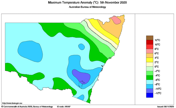
Image 1: Temperature anomalies over NSW on Thursday 5/11/2020, showing cooler temperatures over large parts of the state. Image via BoM.
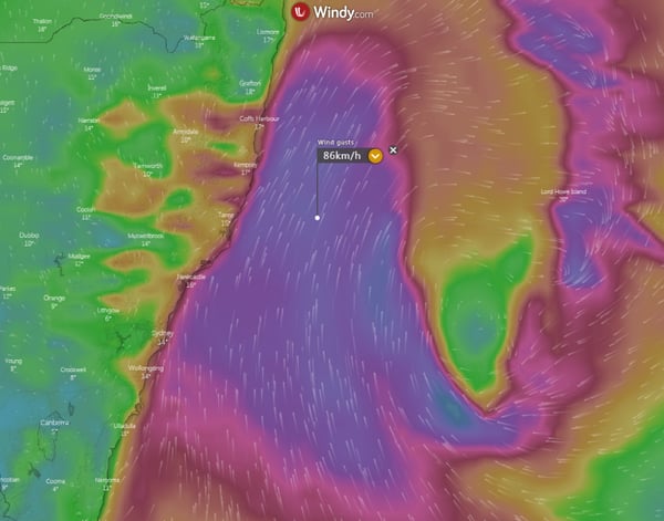
Image 2: The Tasman Low off the coast, driving the cool, wet and windy weather over the state's east (Source: Weatherwatch Metcentre)
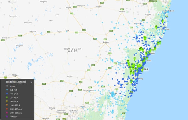
Image 3: 24 hour rain totals to 9am 6/11/2020 across eastern NSW
Tasman low brings rain, strong winds, large surf and chilliest November day in years to central and southern NSW
Friday 6th November 2020
Conditions more typical of winter than late spring affected central and southern New South Wales on Thursday, causing showers, snow over alpine areas and the coldest November day in years in some areas.
A deep southerly surge and Tasman low were behind the dreary conditions, aided by an upper level cold pool crossing over the state. This combination caused thick cloud and areas of rain over eastern NSW, stretching from the Mid North Coast through to the South Coast, with the heaviest falls over central areas.
Across the Sydney Basin widespread falls of 10-20mm were observed, with isolated heavier falls including 33mm at Little Bay, 29mm at Bondi and 30mm at West Pennant Hills. Over the Hunter and Mid North Coast, the highest falls included 42mm at Nelson bay, 45mm at Careys peak (Barrington Tops), 30mm at Williamtown and 27mm at Broke.
Thick cloud and rain greatly reduced temperatures, with some areas up to 13 degrees below average for November and some locations recording their coldest November day in decades. Sydney (Observatory Hill) struggled to just 15.6 degrees, its coldest November day since 1996, whilst Cooma Airport managed hit just 8.1 degrees, its coldest November day since the site opened in 1990. Many other places on the South Coast had their coldest November day since 2010, whilst snow fell in the Snowy Mountains on Thursday morning, bring several centimetres of fresh snow.
The low also caused strong winds and large surf along the coastline, with waves reaching 5 metres and wind gusts of 70-80km/h being recorded. Conditions will remain cool and windy with a few showers along the NSW coast into the weekend due to a high pressure ridge, before warmer conditions develop next week.
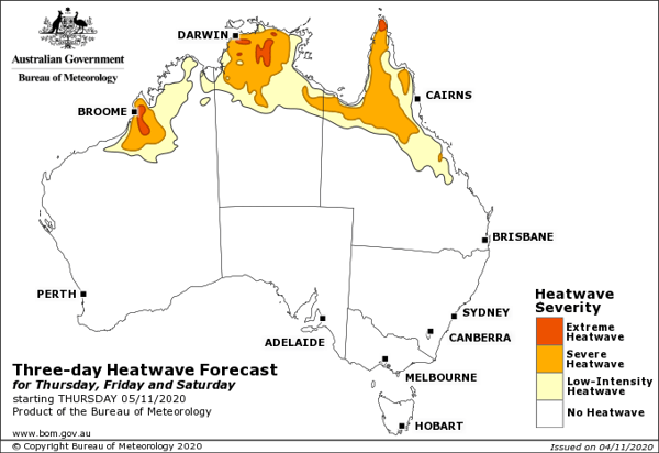
Image 1: Bureau of Meteorology heatwave forecast map for the next three days
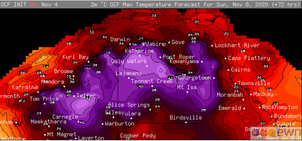
Image 2: OCF Forecast Maximum temperatures on Sunday 8th November, 2020
Heatwave conditions gripping northern Australia
Thursday 5th November 2020
Northern Australia is sweltering in unusually hot conditions for this time of the year as temperatures soar into the mid 40s in some areas, with the stifling conditions expected to continue for at least the next ten days.
A lack of rain and cloud cover has allowed heat to rapidly build across the past week, causing temperatures to soar with temperatures rising three to eight degrees above average. The Bureau of Meteorology's heatwave map indicates many parts of the nation's north will experience severe to extreme heatwave conditions.
Darwin is expected to see a string of 35 degree days (average 33 degrees) after an already hot start to the month, with the seabreeze taking the edge off maximum temperatures further inland. This may not seem like a huge difference from the mean, however significant variations from the average maximum are uncommon in the city with the record average maximum in Darwin for November 34.7 degrees. Those in the rural area will reach into the high 30s throughout the next week.
Tennant Creek is already running several degrees above the average this month (averaging close to 40 degrees), with the mercury expected to reach similar heights throughout the next week, and nights in the mid 20s.
Over northern Western Australia, the month started a little cooler however the heat is expected to grip many parts of the region today. Port Hedland will reach into the low to mid 40s today and low 40s tomorrow, before reaching the high 30s for the remainder of the next week. Marble Bar will average between 41 and 43 degrees throughout the next week (record for November 42.4 degrees).
The heat will begin to break down over the Top End towards mid November as moisture builds and showers and thunderstorms redevelop. However, the heat over Western Australia is likely to continue and even intensify.
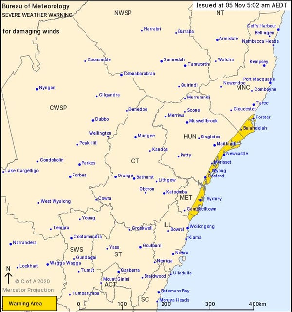
Image 1: Bureau of Meteorology severe weather warning for damaging winds. Image via BoM.
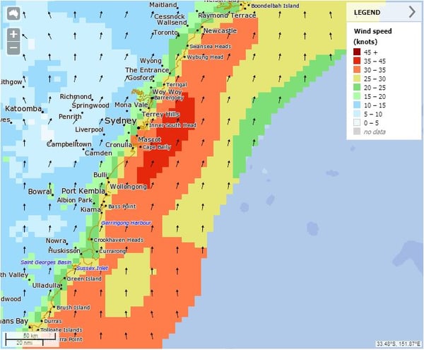
Image 2: BoM Meteye wind graphic. Valid 1700 5/11/2020
Southerly buster is moving through Sydney and central NSW
Thursday 5th November 2020
A strong southerly buster is sweeping through the greater Sydney, Hunter and Mid North Coast region of NSW during Thursday as a low pressure system deepens off the NSW coastline.
Wind gusts are expected to average 60-70km/h across the coastal fringe during Thursday, with locally damaging gusts to 90km/h possible, particularly for exposed coastal locations and elevated terrain.
A large southerly swell will also develop throughout the day, with waves in the 3-5m range expected just offshore.
Winds should gradually ease from the south overnight Thursday and into Friday as this low rapidly moves east towards New Zealand. A severe weather warning is in place for damaging winds.
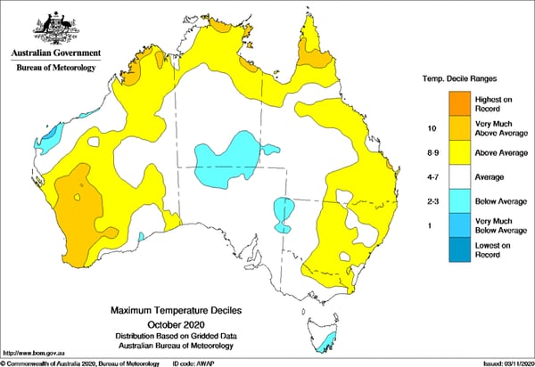
Image 1: Temperature deciles across Australia for October 2020 (Source: Bureau of Meteorology)
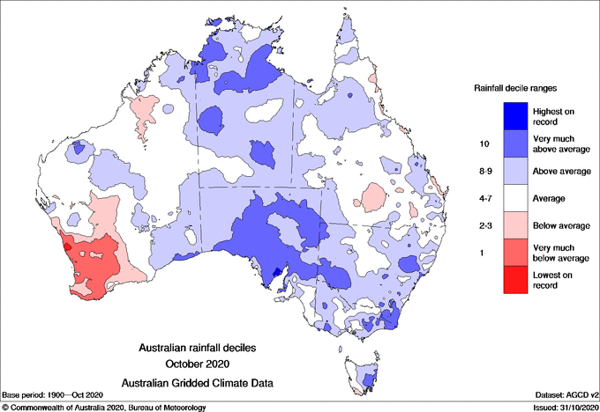
Image 2: Rainfall deciles across Australia for October 2020 (Source: Bureau of Meteorology)
Image 3: Rainfall outlook for November (Source: Bureau of Meteorology)
October 2020: Warm and wet across Australia, severe storms lash the east
Tuesday 3rd November 2020
October 2020 was a warm and wet month across Australia, with most states and territories seeing healthy falls throughout the month, before giant hail lashed the east at the end of the month.
After a La Nina was officially declared on the 29th September by the Bureau of Meteorology, this was the first month of the year under La Nina conditions, with rainfall patterns resembling a typical La Nina pattern.
Rainfall was 35% above average for the nation as a whole, with every state and territory except Western Australia recording above average rainfall. The high rainfall was particularly pronounced over South Australia, parts of the Northern Territory, southwest New South Wales, eastern Victoria, southeast New South Wales and eastern Tasmania where rainfall was very much above average. In a stark contrast, rainfall was very much below average for southwest Western Australia, where some places had their driest October on record.
Temperatures were warmer than average for the month, although significantly cooler than September which was the second warmest on record. The national mean temperature (maximum and minimum temperatures combined) for October was 1.05 degrees above average, with minimum temperatures particularly warmer than average due to enhanced cloud cover. For Victoria, minimum temperatures were the third highest on record (1.62 degrees above average).
The final week of the month saw widespread severe thunderstorms across eastern Australia. Large hail was the standout feature, with reports of hail reaching at least golf ball size on the 24th, 25th, 27th, 28th, 29th and 31st. The 31st was particularly destructive as thunderstorms hit more populated areas, with hail reaching up to 9cm in northeast NSW and up to 14cm in southeast QLD (on the 31st), amongst the largest hail on record in Australia.
November is expected to see similar conditions to October, with temperatures remaining above average and an increased chance of wetter than average conditions.
Recent Articles
Weather News Archive 2018 October
Image 1: 3-day Heatwave Forecast (Weds, Thurs, Friday) - October 31st, 2018
Weather News Archive 2018 July
Image 1. Access R forecast rainfall 8am Wednesday 1st August. Image 2. EC wind gusts 10am 1st...