Damaging Wind Gusts for SE Australia
A powerful cold front sweeping across southeastern Australia will generate damaging wind gusts for...
As of tonight , Wednesday, May 21st, 2025, communities across the Mid-North Coast and Hunter regions of New South Wales are enduring one of the most extreme flood events in living memory. Torrential rains have saturated river systems, shattered historic records, and left tens of thousands stranded while a vast emergency operation continues around the clock.
Ironically, and poignantly, today is also WOW Day (Wear Orange Wednesday), a national day of appreciation for the NSW State Emergency Service (SES) volunteers. Their tireless, life-saving work has never been more vital or more visible than it is this week.
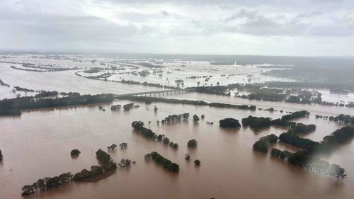
Flooding in the NSW Mid North Coast has seen over 50,000 people cut off. (NSW Rural Fire Service)
A stationary coastal trough and a persistent stream of moisture-laden winds from the Tasman Sea have caused widespread, heavy rainfall from Newcastle to Grafton, with particular intensity in towns such as Taree, Wingham, Glenthorne, Kempsey, and Coffs Harbour. Several of these towns have received up to 412mm of rain in just 48 hours, which is over one-third of their annual rainfall—and the deluge isn’t over yet.
The Manning River at Taree reached 6.4 metres, exceeding the previous 1929 record of 5.97 metres, classifying this as a 1-in-500-year flood event. More than 48,000 people have been isolated, hundreds rescued from rooftops, and thousands of homes and businesses inundated.
The NSW SES has carried out more than 400 flood rescues, supported by nine helicopters working across the region. Emergency-level alerts are now in place for more than 20 river systems, including the Nambucca, Macleay, Hastings, Gloucester, and Paterson Rivers. Roads and transport links are cut, entire communities are isolated, and the list of affected LGAs (16 and counting) continues to grow.
Another 100–200mm of rain is forecast across already saturated regions over the next 48 hours. Some areas, particularly around Kempsey, Coffs Harbour, and Port Macquarie, could see localised totals of up to 300mm. The risk of life-threatening flash flooding remains high as the rain spreads inland and down the NSW coast through Friday.
This weather event is expected to persist until a low-pressure system forms and begins moving southward on Friday, eventually clearing the region by Saturday. But with catchments saturated and river systems already overwhelmed, even moderate rainfall will exacerbate flood impacts.
EWN’s Climatics platform, which compiles historical severe weather data for risk analysis and forecasting, confirms the extreme rarity of this event. The Manning River’s new record peak is not just unusual, it's statistically extraordinary, falling below the 0.2% annual probability threshold.
Taree’s recent two-day rainfall total equals five months’ worth of typical rainfall for May, highlighting the extreme deviation from seasonal norms. Comparative data shows that even the destructive floods of 2021 pale in comparison to this event, which eclipses them by nearly two metres in river height at Taree.
These insights are critical for insurers, emergency services, and government agencies working to understand the scale of the disaster and plan their response.
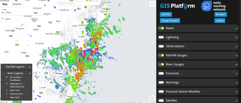
 Rain radar over NSW since Sunday
At Early Warning Network, we are actively supporting emergency services, government partners, and affected industries by:
Disseminating real-time flood alerts and severe weather warnings through our GIS and multi-channel alerting systems.
Providing pre-event forecasts and scenario planning to help businesses, councils and agencies prepare and position assets.
Offering Climatics-derived historical comparisons to support insurance claim validation, disaster declarations, and infrastructure recovery planning.
Delivering tailored alerting services to utilities, transport, mining, and logistics clients affected by road closures and infrastructure threats.
Our systems have been activated across all affected LGAs, and we are continuously updating data as conditions evolve to help communities and responders stay ahead of the danger.
Today also marks Wear Orange Wednesday (WOW Day), a day dedicated to recognising the brave and selfless work of SES volunteers. This year, WOW Day carries even greater significance as thousands of SES members are actively deployed across flood-hit regions, conducting rescues, coordinating evacuations, and ensuring communities receive critical support.

SES volunteers are helping around-the-clock in flood-affected areas of NSW (image via NSW SES)
From winching stranded residents from rooftops to manning evacuation centres in towns like Kempsey and Taree, SES volunteers exemplify courage and community spirit in action. On behalf of the entire EWN team we extend a heartfelt “thank you” to every volunteer making a difference during this crisis.
We urge all residents and organisations in the affected regions to:
Monitor official alerts from EWN, Bureau of Meteorology and NSW SES.
Avoid floodwaters at all costs—conditions remain dynamic and dangerous.
Have an evacuation plan ready, and act early if warnings are issued.
EWN will continue to provide updates and insights as the situation unfolds.
A powerful cold front sweeping across southeastern Australia will generate damaging wind gusts for...
Tropical Cyclone Alfred has now turned towards land, intensifying as it approaches the southeast...
The last few days has been extremely active weather wise acoss southeastern and southwestern...