Northern Queensland Floods: A Record-Breaking Crisis and the Road Ahead
The start of 2025 has brought unprecedented challenges to North Queensland, with Townsville and...
It’s been a long build-up to the monsoon for residents across northern Australia, with their faith wilting with time. However, that faith will be restored this week, with the first monsoon for the season about to kick off spectacularly.
Showers, storms, and rain periods have recently increased in coverage across the Northern Territory as a weak low hovers over the Darwin region. This will increase further this week and through the weekend as the first monsoon burst of the season arrives.
What is the Australian Monsoon?
Typically, east-southeasterly winds prevail across northern Australia, resulting in dry conditions and high fire danger. During the spring, the build-up begins with hot temperatures baking northern Australia. The vast land mass across northern Australia heats faster than the surrounding ocean, resulting in pressure differences or areas of lower pressure. This area of low pressure acts like a giant vacuum, dragging moisture-laden northwesterly winds from Indonesia to Australia, resulting in an increase in rainfall and cloud cover.
Northwest monsoon winds strengthen across northern Australia this week into next weekend. Video via Windy.com
This increase in rainfall and cloud cover also helps cool the previously unbearable temperatures that stifle the region in the months leading up to the onset of the monsoon.
This developing monsoon will strengthen further in response to the Madden-Julian Oscillation as it moves across northern Australia over the coming weeks.
The Madden-Julian Oscillation, or MJO, is an eastward moving zone of wind, clouds, and rainfall that circles the equator every 30-60 days. The progression of the MJO is split into eight different areas, with phases four, five, and six impacting Australia. The current phase of the MJO is phase three, which is the area northwest of Australia. The MJO is forecast to move into phases four, five, and six (areas north and east of Australia) over the next couple of weeks to strengthen this monsoon further.
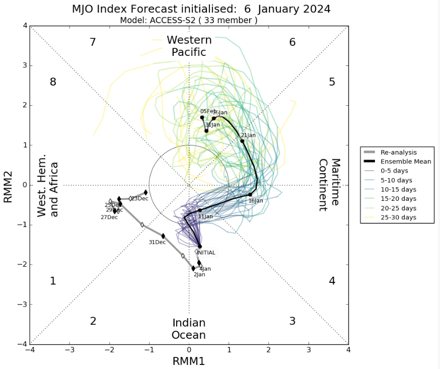
Madden-Julian Oscillation forecast. Image via Bureau of Meteorology.
During this period, the threat of tropical cyclone development also increases. The Bureau of Meteorology 7-day Tropical Cyclone forecast table forecasts a 25% chance, or moderate chance, of a Tropical Cyclone developing across northern Australia by next week. Due to the time frame and uncertainty around where this low may be a significant potential spread exists in the 5-7-day period.
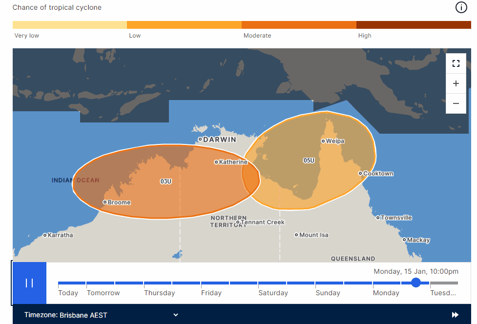
7-day Tropical Cyclone Chances. Gif via Bureau of Meteorology.
While a marked increase in shower and storm activity can be expected for the rest of the week, the real action looks to fire up across the weekend as a monsoon low develops. As mentioned, where this low develops is still uncertain, with forecast models chopping and changing between the Northern Territory and northern Western Australia. The setup of this low will significantly affect where the heaviest rain falls. Whether it develops over land or just off the coast will also play a significant role in the potential for Tropical Cyclone development.
As it stands, parts of the western Top End and northern Kimberley region of WA will likely see widespread accumulated rainfall totals of 100-300mm over the next 5-10 days, with higher falls to 500mm for some locations. Heavy rainfall will also increase across Queensland's Gulf and western Peninsula region as the westerly monsoon flow increases later this week.
Significant flash flooding and riverine flooding are expected in response across northern Australia, with a flood watch likely to be issued later this week from the Bureau of Meteorology.
The start of 2025 has brought unprecedented challenges to North Queensland, with Townsville and...
It’s rinse and repeat for inland Australia, with the third flood event of 2024 inundating western...
It was the most hotly-discussed weather content on the internet for the better part of a week, and...