

Heavy rainfall to develop through Central and Southern Queensland
Parts of central and southern Queensland will see an increase in rain and storms this weekend as a...
It’s rinse and repeat for inland Australia, with the third flood event of 2024 inundating western Queensland and the Northern Territory.
(Title Image: Birrindudu homestead surrounded by floodwater.(via ABC Listen, image taken by Grace Perry)
Another monsoon burst has delivered the fourth tropical cyclone crossing for the season, leading to extensive flooding across flood-ravaged regions of the Northern Territory, the Gulf Coast, the North Tropical Coast, and the western half of Queensland.
For the third time in as many months, a tropical low or tropical cyclone has travelled through the Northern Territory, dumping hundreds of millimetres of rain.

Four tropical cyclones have made coastal crossing during the 2023/24 season. Image via Australia Severe Weather
During mid-January, a tropical low within a strengthening monsoon trough drifted over Darwin and its surrounds before moving across inland parts of the Northern Territory and eventually drifting into Western Australia. This low was not just any low; it was a record-breaker. It shattered numerous January rainfall records across the NT. Port Keats Airport, for instance, received an astonishing 334.8mm of rain on January 15, surpassing its previous highest daily rainfall total for January of 230.6mm from January 4, 2008. This was one of many records broken. Port Keats also registered its highest January rainfall total in history, reaching a staggering 1051.2mm for the month, surpassing the previous best of 820mm in 2015.
This unprecedented rainfall led to extensive minor to major flooding across the region, causing significant disruptions. Communities were cut off, and trucks carrying vital supplies were stranded for days, exacerbating the already challenging situation.
By the time mid-February rolled around, another pulse of the MJO (Madden -Julian Oscillation) saw an increase in tropical activity across northern Australia. This led to the development of tropical cyclone Lincoln in the Gulf of Carpentaria. Once Lincoln crossed the coast, it didn't just disappear. It continued its journey, drifting in a southwesterly direction across central parts of the Northern Territory and renewing flooding for many riverine systems.
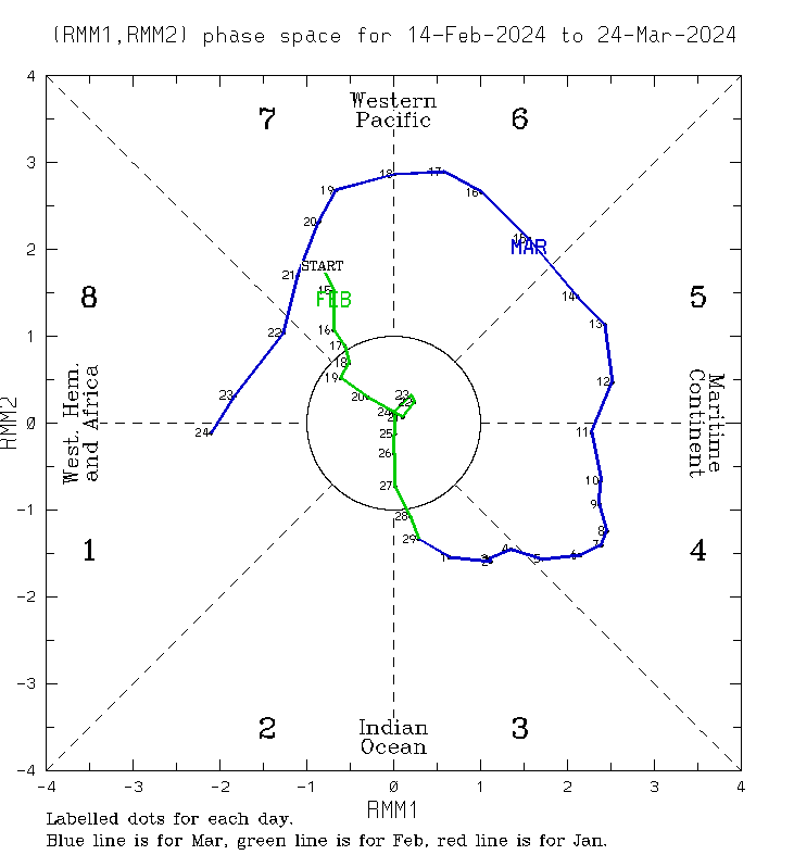
Madden-Julian Oscillation for the past 40 days. Image via BoM
Once again, a large flood watch was issued across the NT, with rivers expected to respond rapidly to heavy rainfall. Rainfall records were set for February, this time across the Carpentaria and Arnhem region, with Bing Bong Port, Warramunga, Central Arnhem Plateau, Foelsche Headland, and Groote Eylandt AP registering their highest daily February rainfall totals in history. Bing Bong Port recorded 803.8mm for the month, breaking the previous record of 728.4mm set back in 2017.
The rain ha transformed the outback over the course of one of the wettest seasons on record.
Numerous river systems across the Northern Territory and Queensland have been under a flood watch over the past 10 days. Image via EWN
Lincoln also produced heavy rainfall across the Gulf and North West region of Queensland. Several sites saw their highest daily rainfall totals for February. These included Sweers Island, picking up 227mm on the 16th (previous 216mm back in 2017, and Burketown Airport, which saw 154.6mm, beating 135.6mm from 2017.
Westmoreland Station, situated in western Queensland, near the Northern Territory border, racked up an incredible 934.2mm for February, absolutely obliterating its previous February rainfall record of 806mm that fell back in 2001. Westmoreland Station’s average rainfall for February is just 247.9mm.
Fast-forward four weeks to mid-March, and severe tropical cyclone Megan also crossed the Carpentaria Coast of the Northern Territory, almost in an identical spot to Lincoln. Megan, too, drifted southwest into central parts of the NT.
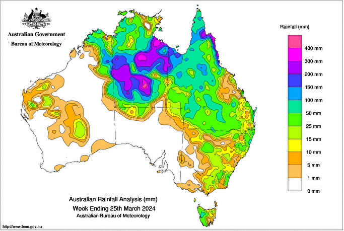
Rainfall totals across Australia for the week ending 25th March. Image via BoM.
Groote Eylandt Airport registered 680.4mm over 48 hours, with a whopping 431mm of that falling during the 24 hours to 9am of the 17th. This was a new daily rainfall record for this site in March, smashing the 313mm that fell in 2004! Borroloola Airport joined the party with 114mm falling on the 18th and a new daily March record of 256.6mm on the 19th. This beat the previous March daily total of 153.2mm in 2006 and is also this site's highest daily total across any month.
Heavy showers and storms will continue through the Territory and Queensland over the coming days, with pockets of heavy rainfall likely to linger.
Further falls will aggravate existing flood problems for many across the region. However, with such extensive rainfall falling across western and northern Queensland over the past few months, runoff has finally found its way into Lake Eyre in South Australia.
Lake Eyre will slowly fill over the coming months as flood waters trickle south from overflowing river systems across western Queensland.
Parts of central and southern Queensland will see an increase in rain and storms this weekend as a...
Over the past 24 hours, central and southern parts of Queensland have experienced widespread,...
Communities across New South Wales and South East Queensland are bracing for even more wet weather,...