It’s no dry July for Queensland
There will be no dry July for Queensland as record-breaking rainfall swept across the state this...
Rain and thunderstorms have drenched parts of Australia since Monday, with some areas seeing their best falls in almost two years, with more coming over the next week.
In a very atypical weather pattern for an El Nino event, a slow-moving high over the Tasman Sea is pumping moisture (due to persistent onshore winds) into a trough lying across the nation's eastern interior, producing widespread areas of rain and thunderstorms which are expected to persist into next week.
Many parts of central and southern Queensland, northern and southern New South Wales (including the ACT) as well as northeast Victoria have received moderate to heavy falls, which have been widespread in QLD and northern NSW, but more patchy elsewhere.
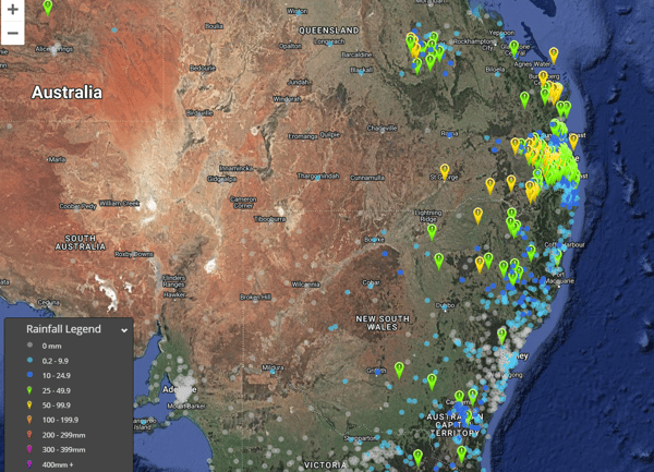 48hr rainfall totals in the 48 hrs to 4pm yesterday (Image via EWN GIS platform).
The drought-stricken QLD Wide Bay has seen their best falls in at least a year, with widespread falls of 40-70mm, whilst over the central QLD interior has seen falls of 20-70mm. In southern QLD, widespread totals of 30-80mm have occurred, with localised totals above 100mm. At Gatton, 83mm fell in the 24 hours to 9am today, the heaviest fall since the February 2022 floods.
Over the bushfire hit Darling Downs and Granite Belt as well as the Maranoa and Warrego, many areas saw their best falls in 6-18 months, with notable falls including Stanthorpe (67mm), Inglewood (65mm), Goondiwindi (53mm) and St George (77mm). A moderate flood warning is current for the Moonie River, an area that was hit by devastating bushfires just a few weeks ago.
Rain and thunderstorms are set to continue for at least the next week over eastern Australia as the trough continues to be fed by a deep onshore flow. The focus of these will be mainly on and west of the ranges, before activity begins to shift closer to the coast on Friday and over the weekend, as well south into eastern SA, VIC and TAS. Some of these storms have potential to be severe at times, bringing the risk of damaging winds, large hail and very heavy rainfall leading to flash flooding.
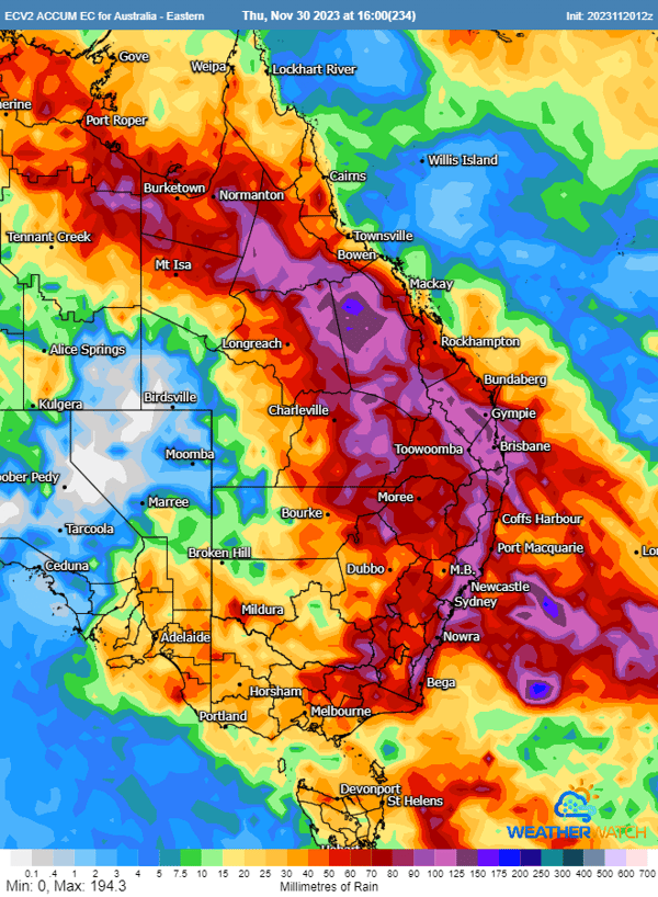 Accumulated precipitation across the next 10 days from the ECMWF model (Via Weatherwatch
The dynamics of this system will likely become more complex over the weekend and into early next week as well, due to upper level cold pools approaching from the west. This aided upper level support may cause low pressure systems to form over the weekend, firstly over VIC and TAS, and then again possibly over southeast QLD and northeast NSW early next week. Heavy rainfall is possible near these lows, particularly over northeast NSW/southeast QLD where there will be more moisture.
Whilst there is some uncertainly later in the week and early next week, widespread rain is still likely across the eastern half of the country. Rainfall totals will vary considerably from location to location, however most areas will see at least 20-60mm from these systems (including into southeast SA). Those over eastern QLD and NSW may see even greater totals of 100-200mm. Minor to moderate riverine flooding is likely in some areas, as well as localised flash flooding.
There will be no dry July for Queensland as record-breaking rainfall swept across the state this...
South East Queensland is on flood alert with a significant rain event developing.
A strong upper...
The last few days has been extremely active weather wise acoss southeastern and southwestern...