La Nina is over - so what is ahead for Australia?
La Nina was officially declared over yesterday by the Bureau of Meteorology as sea surface...
Tropical Cyclone Jasper barrelled across the western Coral Sea late last week, through the weekend as a powerful category 4 system, before running into an invisible brick wall (called wind shear and dry air) - resulting in a rapid weakening of Jasper, which left the system looking anaemic on Monday.
What is wind shear, and how does it affect a tropical cyclone?
Wind shear is a change of wind direction and speed with height throughout the atmosphere, and there are two types of wind shear: horizontal and vertical.
Vertical wind shear changes direction and speed with height and is the most influential for tropical cyclones. In contrast, horizontal wind shear is a change in speed and direction at the same level.
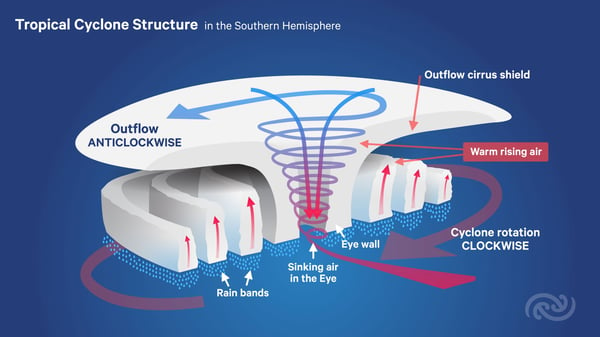
Tropical Cyclone structure. Image via Science Media Centre
Strong vertical wind shear is required for severe thunderstorm development and significantly contributes to supercell thunderstorms and tornado development. When strong vertical wind shear is present around a tropical cyclone, the system becomes tilted, unravels, and ingests dry air into the circulation, weakening the system – as we have seen with Jasper over the last 48 hours.
Conversely, low vertical wind shear enables a tropical cyclone structure to become vertically stacked, which helps maintain intensity and grow the system. This was highlighted late last week as Jasper rapidly strengthened into a severe category 4 system.
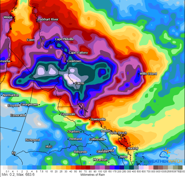
ICON accumulated precipitation next 120-hours. Image via WeatherWatch
On Sunday and Monday, Jasper encountered a strengthening of this vertical wind shear, ripping the system apart, which saw it weaken rapidly, leaving it a washed-out version of its former self. Overnight Monday and into Tuesday morning, things changed again.
Vertical shear decreased, and powerful convection began to develop around the circulation again, with an intensification process well underway. Jasper is still a category 1 system with wind gusts up to 120km/h near its center. With another 24-36 hours in open water, there is plenty of time for Jasper to strengthen into a Category 2 system, with an outside chance of becoming a severe Category 3 system as it approaches the coast late tomorrow. However, this is highly dependent on Jasper’s speed towards the coast.
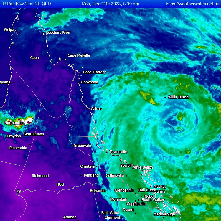
IR 24-hour satellite loop of Tropical Cyclone Jasper showcasing overnight intensification. Gif via WeatherWatch
A category 2 system would produce destructive wind gusts of up to 150km/h, heavy rainfall, and a tidal surge, with Jasper expected to land on high tide Wednesday.
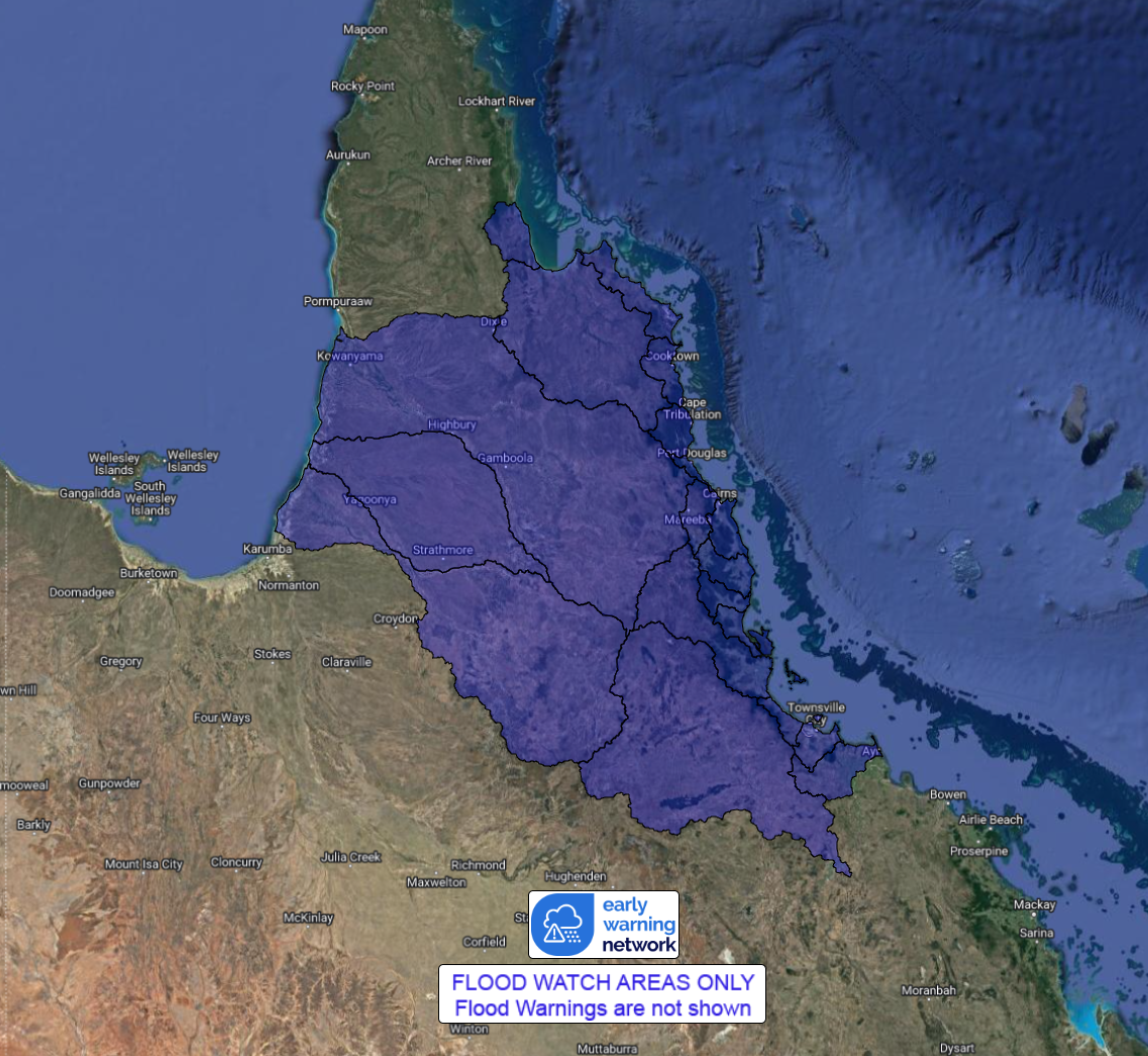
Flood watch catchment areas across North Queensland. Image via EWN
Heavy falls of 200-400mm will develop as this system impacts North Queensland, leading to life-threatening flash flooding and riverine flooding, some of which may be major flooding. A flood watch remains current for this region. Parts of the Mackay and Whitsunday region have already seen heavy rainfall totals in the 24 hours to 9 am this morning, with Clarke Range (inland of Mackay) registering 270mm.
Other notable totals include;
- Eungella 129mm
- Upper Finch Hatton 147mm
- Sarina 111mm
- Preston 111mm
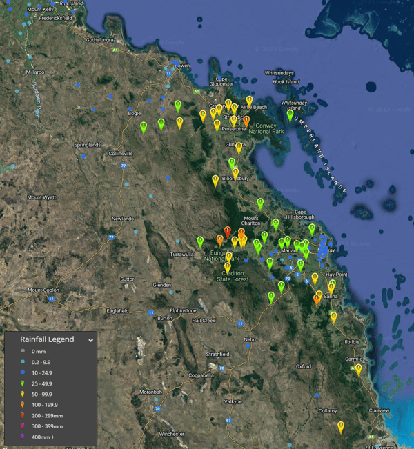
24-hour rainfall totals to 9am 12/12/2023. Image via EWN
Isolated damaging wind gusts have also impacted parts of the Whitsunday Islands, with Hamilton Island Airport registering a gust of 93km/h on Monday evening.
A tropical cyclone warning remains current for coastal communities from Cape Flattery to Townsville, including Cairns, with a tropical cyclone watch extending from Cape Melville to Cape Flattery, extending inland to include Palmerville.
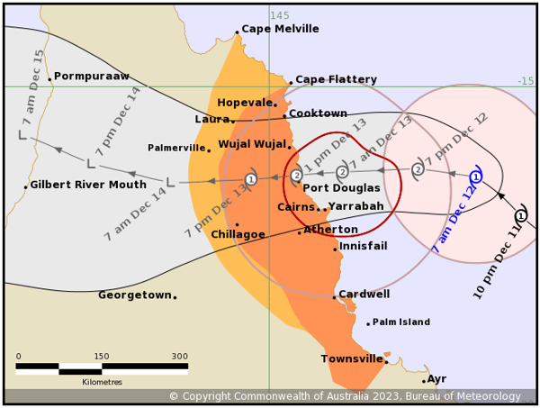
Tropical Cyclone Jasper track map. Image via Bureau of Meteorology
Jasper currently sits around 265km east-northeast of Cairns and is moving northwest at 14 kilometers per hour.
La Nina was officially declared over yesterday by the Bureau of Meteorology as sea surface...
This is not a drill; Rainfall will increase across parts of Queensland and NSW over the next week....
Australia has been put on a La Nina Alert, according to the latest ENSO (El Nino Southern...