Jasper the ghost no more: Re-intensification underway and eyeing off the North Queensland coastline
Tropical Cyclone Jasper barrelled across the western Coral Sea late last week, through the weekend...
La Nina was officially declared over yesterday by the Bureau of Meteorology as sea surface temperatures in the tropical Pacific Ocean returned close to normal, so what is the outlook ahead for Australia over the coming months?
The La Nina event, which started in September 2020 has helped bring above average rainfall for large parts of the country over the last six months (with the exception of November), as well as contributing significantly towards the nation's coolest summer in nine years.
El Nino Southern Oscillation (ENSO) events tend to break down later in summer and autumn, as we have seen so far this year. So with a return to neutral conditions, what weather can Australia expect to see for the remainder of autumn and into winter?
Most model outputs suggest that a neutral ENSO state is likely for the remainder of autumn and winter. This means ENSO is likely to have little impact on the nation's weather for the coming months, with the Madden-Julian Oscillation (MJO), Southern Annular Model (SAM) and Indian Ocean Dipole (IOD) likely to influence the weather more.
While the IOD and SAM are currently neutral, a moderate MJO pulse will play the biggest role in the nation's weather in the coming weeks, with a pulse expected to bring increased rainfall across the north and potentially east of the country over the next couple of weeks. However, over the next two to three months, there are no clear indications of wetter or drier conditions due to neutral climate drivers.
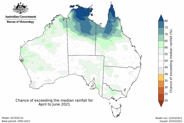
Image 1: Rainfall outlook from April to June (Source: Bureau of Meteorology)
Looking even further ahead there are some indications from around mid-winter a negative IOD event may develop. Negative IOD events tend to bring wetter conditions to large parts of Australia during winter and spring, with the last significant negative IOD event in 2016. ENSO is expected to stay neutral until at least early spring, although some models are indicating a shift towards La Nina conditions once again mid to late spring. With this a number of months away it is hard to lock anything in, but it looks unlikely we will shift back into El Nino conditions this year.
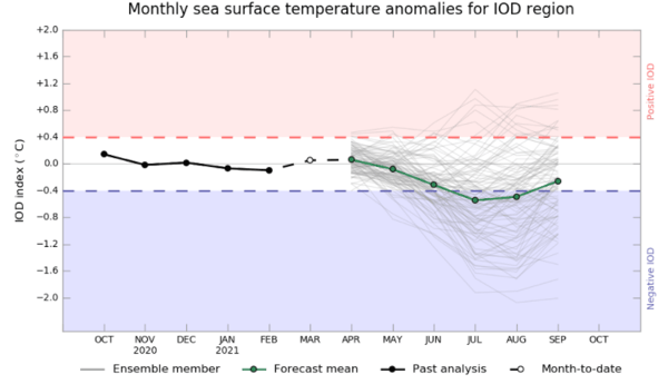
Image 2: Indian Ocean Dipole Outlook (Source Bureau of Meteorology)
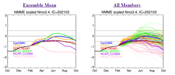
Image 3: Nino3.4 (ENSO) outlook from NOAA (Source: CPC)
Tropical Cyclone Jasper barrelled across the western Coral Sea late last week, through the weekend...
Climate risk and other natural hazards are a recurring nightmare for governments, as they can...
Australia’s Tropical Cyclone season has officially begun, running all the way through until April...