Severe thunderstorms and heavy falls across central Queensland
Another bout of severe weather impacted Queensland on Saturday afternoon, with severe thunderstorms...
Severe thunderstorms erupted across Eastern Queensland on Wednesday afternoon with severe flash flooding and locally damaging winds developing during the late afternoon and evening hours.
An outflow boundary marched east during the afternoon, intersecting with a southerly change surging up the Northern NSW coast. These two in combination produced a large complex of slow-moving, intense storms across the Eastern Darling Downs and Western SE QLD Coast.
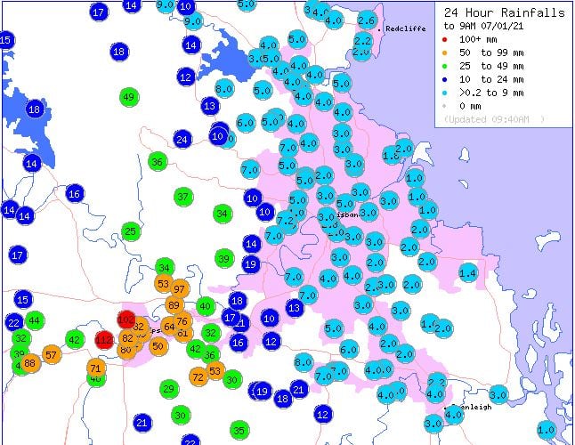
Beaudesert, in the Scenic Rim picked up 83mm in an hour prompting a Very Dangerous Thunderstorm warning for life-threatening flash flooding. This was just the beginning with several storms developing further northwest in a line, also becoming VDS thunderstorms with Woodlands Road (West of Laidley) recording 57mm in one hour, and Highfields (North of Toowoomba) recording 68mm in an hour.
Into the early evening, the Standard Emergency Warning Signal was activated with Amberley copping a deluge as 86mm fell with the space of an hour, before eventually registering a total of 112mm in the 24 hours to 9am 7/01/2021. The 112mm to 9am this morning made it Amberley's wettest January day in 8 years (2013).
Other notable totals include Brassall 102mm, Karalee 89mm, Rosewood 88mm and Spring Mountain 72mm. Further east across coastal regions, only light falls were recorded, with totals generally remains below 20mm, with the Brisbane CBD only recording 3mm.
Image 1: 24 hour rainfall totals to 90a 7/01/2021. Image via BoM.
Another bout of severe weather impacted Queensland on Saturday afternoon, with severe thunderstorms...
Over the past 24 hours, central and southern parts of Queensland have experienced widespread,...
Severe thunderstorms returned once again to parts of southeastern inland and coastal QLD yesterday...