Heavy rainfall to develop through Central and Southern Queensland
Parts of central and southern Queensland will see an increase in rain and storms this weekend as a...
Over the past 24 hours, central and southern parts of Queensland have experienced widespread, substantial rainfall, resulting in flooding reminiscent of the devastating 2022 floods. Additionally, record-breaking levels of rainfall have been observed in certain localised areas.
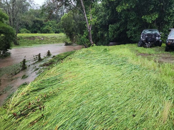 Image of flooding levels seen in the Samford Valley area, from EWN's Cameron Hayes
Ex-Tropical Cyclone Kirrily has fed a very humid airmass into a trough across the state, triggering widespread areas of rain as well as localised thunderstorms resulting in intense rainfall for some areas.
For many inland areas, the rain has been welcomed, with widespread falls of 30-80mm across interior parts of southern and central QLD. As a result of localised thunderstorms, heavy rainfall and flash flooding have occurred in certain areas. St George has experienced a significant downpour of 113mm up until 9am today, marking its heaviest rainfall since May 2022 , and largest January rainfall since 2004.Additionally, a wind gust of 102km/h was recorded. Lesie Dam has also seen substantial rainfall, measuring 100mm up until 9am, making it the wettest day since February 1995, whilst the areas north of Dalby receiving falls of 100-150mm, and Marnhull witnessing its wettest day since records began in 1900, with a total of 159mm.
Moving east, areas of Wide Bay & Burnett experienced substantial rainfall of 50-120mm, with Woodgate receiving a remarkable 114mm. The Scenic Rim also witnessed a drenching with widespread totals of 50-120mm, adding to the heavy falls over the weekend caused by powerful thunderstorms. Unfortunately, this led to major flooding in certain areas, including the town of Laidley, where floodwaters inundated the town centre and its surroundings.
.jpeg?width=605&height=454&name=1706562099564%20(1).jpeg) Image of flooding levels seen in the Samford Valley area, from EWN's Cameron Hayes
Image of flooding levels seen in the Samford Valley area, from EWN's Cameron Hayes
In the region just north of Brisbane, including the Morayfield, Caboolture, and Samford areas, the most significant rainfall totals were recorded. These impressive amounts, ranging from 100-300mm and even reaching as high as 351mm in Samford, were a result of intense thunderstorms caused by converging weather systems. The heavy downpour led to severe flash flooding reminiscent of the devastating floods experienced in 2022.
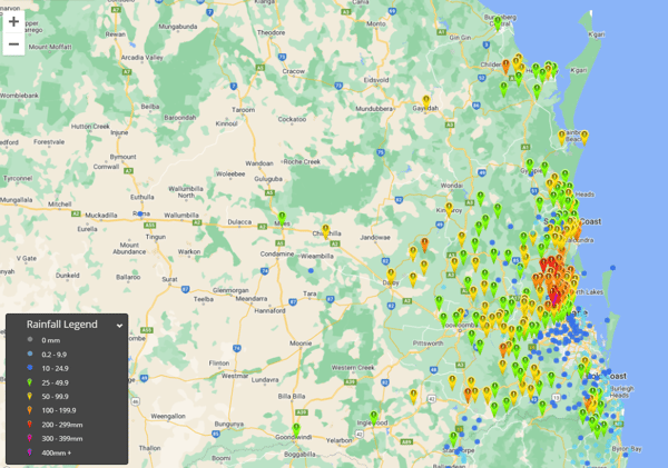 Accumulated rainfall totals in the 24hrs to 9am, 30 Jan 2024. Image via EWN
Continuing throughout the day, this weather system will unleash torrential rainfall in select areas, particularly in the northern regions of the southeast coast and Wide Bay. Keep an eye out for a small sub-tropical low that is anticipated to form off the southern coast of Queensland. This low-pressure system not only brings a sudden burst of southeasterly winds but also carries the potential for substantial rainfall in the Sunshine Coast and Wide Bay areas. We could see further rainfall amounts ranging from 100-250mm, with the possibility of isolated higher falls. This raises the risk of flash flooding and potentially moderate to major riverine flooding.
In regions away from the low situated over the Capricornia and Central Highfields and Coalfields, thunderstorms are expected to bring intense rainfall due to the exceptionally high moisture levels. These storms will be isolated in nature, resulting in some areas experiencing heavy falls of 100-200mm, while others may see little to no rainfall.
Looking ahead to Thursday, the rain and storms will gradually diminish as they move towards the northern tropics, allowing for a drier southeasterly flow to sweep across the state.
At EWN, our teams are continuing to work with local businesses and councils to deliver real-time flood alerts and severe weather warnings directly to residents, and provide council teams in-depth analyses of impending weather events. This proactive approach enables councils to make informed decisions, safeguarding their communities and mitigating the impact of such intense weather patterns. If you would like to talk to our team about how we can help your business prepare, please contact our team today.
Parts of central and southern Queensland will see an increase in rain and storms this weekend as a...
Western Australia’s South West Land Division has been peppered with showers, severe storms, and...
As the tropical low in the Coral Sea intensifies, it's crucial for residents in eastern Queensland...