A meandering cut-off low to cause havoc for southern Queensland and NSW – with an East Coast Low likely
While severe weather has hammered northern Australia over the past few months, the focus has...
Parts of central and southern Queensland will see an increase in rain and storms this weekend as a cut-off low moves into the state, helping to deepen a trough or low to its east.
Subtle upper-level disturbances will cross eastern Australia this week, helping to increase instability. This could lead to thunderstorms in parts of eastern NSW and southern Queensland, which could see further severe activity.
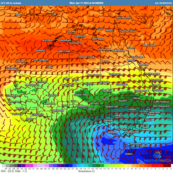
Upper systems traversing southern Australia, with an impressive lobe of cold air aloft (cut-off low) drifting through
NSW and Qld. 500MB temps & winds via WeatherWatch MetCentre.
However, all eyes will quickly shift to an amplifying upper-level trough moving north through NSW into southern Queensland late Friday before developing into a cut-off low. This low will bring a lobe of frigid air aloft into the western Darling Downs and North West Slopes and Plains of NSW, helping to increase instability. Showers and storms will develop through this region, with hail a high probability. Although large quantities of accumulated hail are likely, large hail cannot be ruled out, with 2-3cm hail possible through this region.
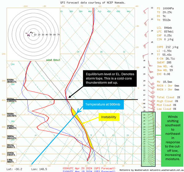
Thunderstorm sounding taken in northern NSW Saturday. Image via WeatherWatch MetCentre
Significant hail accumulations can cause enormous stress on roofs of houses, particularly shopping centres, with collapses possible should enough hail fall. With such cold temperatures aloft, lots of smaller hail (below the severe threshold of >2cm) can damage cars and crops and severely impact animals and people caught outside.
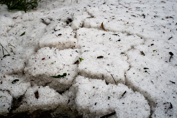
Large small hail accumulation can lead to collapsed roofs. Image via EWN's James Harris.
As mentioned in a previous post (highlight the previous post with a link to the last story about a cut-off low / NSW event), cut-off lows act as a giant vacuum, sucking or lifting the air ahead of it. This lift mechanism, in combination with an extensive high-pressure system through southern Australia, will pump moisture-laden easterly winds onto the coastline, helping develop a surface trough or surface low to the east of the cut-off low.
This will increase showers, rain periods, and thunderstorms for parts of the Capricornia Coast, Wide Bay and Burnett, Southeast Queensland Coast, Darling Downs, Central Highlands and Coalfields, and potentially Northern Rivers and Northern Tablelands of NSW.
These systems are notoriously hard to predict due to their meandering nature. However, confidence is firming for widespread showers, storms, and rain periods. Falls of 20-50mm over the next 5 to 7 days are expected at minimum.
EC 10-day rainfall accumulation: Image via Windy.com
Rainfall for the Capricornia Coast, Central Highlands and Coalfields will be welcomed, as drier than average conditions have continued to hamper the region. Despite Rockhampton already seeing an impressive 88.6mm since April 1 (just over double the April average of 42.4mm), three-month rainfall deficiencies were below average to the end of March. Rockhampton registered just 186.6mm from January 1 to March 31, well below the three-month average from the same period, which sits at 372.8mm.
.png?width=600&height=544&name=image%20(1).png)
Queensland rainfall deficiencies 1st January - 31st March 2024. Image via BoM
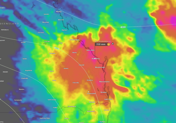
Although widespread major flooding is not expected, accumulated rainfall totals of 100-200mm are likely, with higher falls of 200-400mm for coastal regions of Queensland under convergence zones or rain trains.
Any areas under this type of rainfall will see significant flash flooding and some riverine flooding. Flood watches are expected to be issued during the coming days.
.png?width=600&height=601&name=image%20(2).png)
OFC Accumulated precipitation next 7 days. Image via WeatherWatch MetCentre
The EWN team provides a comprehensive suite of flood-related services designed to enhance safety and preparedness for flood events across the country. These services include:
Flood Forecasting and Alerts:
24/7 flood alerting which utilises data from local rainfall systems and the Bureau of Meteorology. These services are customised to the specific rain and flood level trigger points of different areas, ensuring timely and relevant alerts.
Customised Alerting System:
We provide options for both automatic and manually filtered alert systems. The automatic system sends alerts immediately when predetermined thresholds are reached, while the manually filtered system involves checks by our expert team to avoid false alarms. Alerts can be distributed via SMS, email, voice call, or push notification.
Real-Time Monitoring and Alerts for Various Weather Events:
Beyond floods, EWN also monitors and alerts for other severe weather events like thunderstorms, cyclones, and bushfires. This broad scope helps users stay informed about multiple potential hazards.
While severe weather has hammered northern Australia over the past few months, the focus has...
Just two weeks after moderate to major flooding affected parts of South Eastern Queensland and...
A major rain event is poised to spread across the central interior of Australia next week ahead...