Even more widespread rain and storms for NSW and QLD
Showers, storms and cooler weather is on the way for many parts of New South Wales and Queensland...
The oppressive heat hammering parts of South Australia will go out with a bang on Friday ahead of cooler conditions and heavy rain into the weekend.
A low-pressure trough will lie across central parts of the state on Friday, separating two air masses. To the south of this trough, cooler conditions will prevail with fresh southerly winds. Stenhouse Bay will see a maximum temperature of just 23°C on Friday, with Ceduna topping at 29°C, Port Lincoln 26°C, Edithburgh 29°C and Robe 23°C.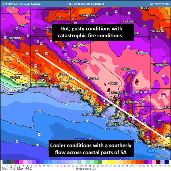
GFS forecast temperatures for Friday. Image via WeatherWatch
These maximum temperatures starkly contrast towns north of this low-pressure trough, with temperatures up to 20°C warmer.
Woomera is expecting a maximum temperature of 47°C on Friday, with Port Augusta to hit 45°C, Roxby Downs 48°C (would be a new site record for December if reached), Snowtown 43°C, Jamestown 41°C, with Adelaide expecting 36°C. Hitting 50°C is not out of the question; however, the likelihood of this impacting an official automated weather station is slim.
The Bad News
Not only will the temperatures cause issues for many tomorrow, but severe wind gusts are also expected across the state on Friday, with gusts to 100km/h possible. Scorching temperatures and damaging winds will lead to catastrophic fire danger on Friday for parts of the Eastern Eyre Peninsula, Flinders, Mid North, Yorke Peninsula, and Riverland fire weather districts. Numerous high-based thunderstorms will also develop during the afternoon, threatening further damaging winds in the form of dry microbursts and dry lightning strikes.
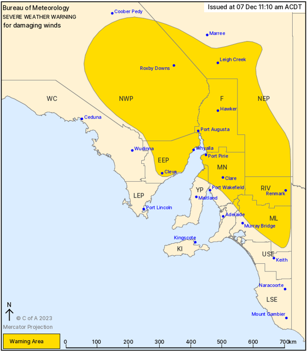
Severe Weather Warning for damaging wind gusts. Image via BoM
These factors above may lead to the most intense fire weather threat for the season in South Australia – meaning containing any fires that materialise nearly impossible.
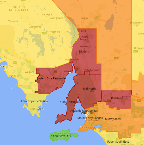
Catastrophic fire danger forecast for Friday 8th December. Image via EWN
The Good News
Relief is on the way, with a much cooler south-southeasterly flow filtering across the state, undercutting a thickening cloud and rain band set to develop - contracting all that heat into northeastern South Australia, Queensland, and NSW.
Maximum temperatures will crash, with a staggering contrast in temperatures on Saturday compared to Friday. Roxby Downs will drop from 48 °C to 26 °C Saturday, Woomera 47°C to 24°C, Snowtown 43°C to 20°C, with Adelaide expecting a maximum of just 21°C.
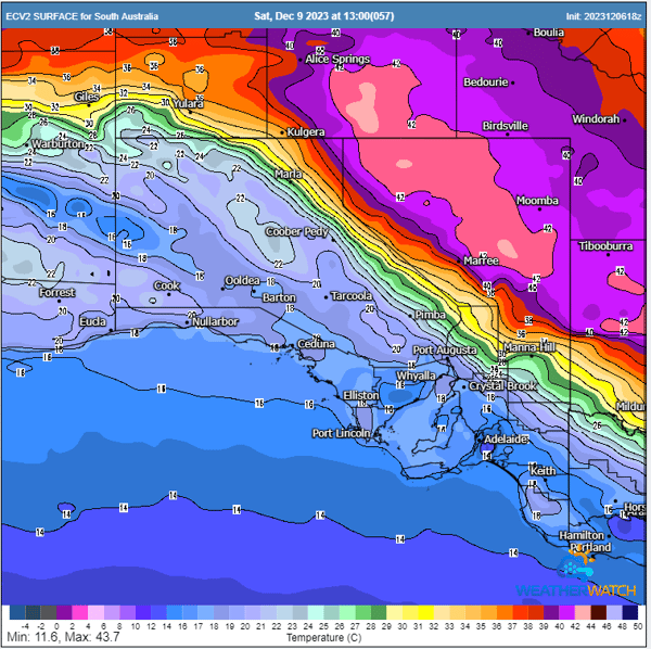
EC forecast temperatures for Saturday. Image via WeatherWatch
A potent upper trough will move into the region from the southwest on Friday, helping to draw moisture south from northern Australia during Friday and Saturday, generating shower and storm activity across northern and central parts of South Australia. This upper system will then be ‘cut off’ from the belt of westerly winds aloft, forming a closed upper low. This cut-off low will then stall and retrograde in a westerly direction late Sunday through early Tuesday.
GFS 500mb flow - showcasing the upper trough into a cut-off low. Gif via WeatherWatch
The Ugly News
A moisture plume will wrap around this system, generating areas of heavy rainfall through parts of Flinders, Mid North, Eastern, and Lower Eyre Peninsula, North West Pastoral, West Coast District, Mount Lofty, and Adelaide regions.
This cut-off low will help induce a surface low to its east, which will be dragged west under the influence of this cut-off low, strengthening significantly during Sunday and Monday. Damaging wind gusts will wrap around this low's western and southern periphery, with heavy rainfall forecasted to fall across the region. Widespread falls of 30-80mm are likely, with intense falls of 100-170mm possible.
GFS Mean Sea Level Pressure and Precipitation next 160 hours Gif via WeatherWatch
The heaviest rain will fall on Sunday through central parts of the state, with a significant rain and cloud band extending from near Kangaroo Island north to Ondadatta.
Rainfall of this nature would see numerous towns score three or four times their December average, with many locations averaging just 20-30mm for the month. December daily rainfall records would also come under serious threat from heavy falls.
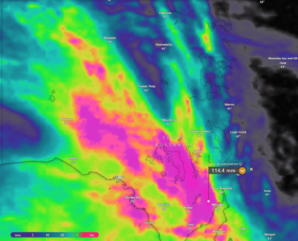
EC accumulated rainfall next 10-days. Image via Windy.com
A small tidal surge may also impact low-lying coastal islands and communities across central areas of South Australia, along with large waves and powerful surf conditions once this surface low shifts westward overnight Sunday into Monday.
Showers, storms and cooler weather is on the way for many parts of New South Wales and Queensland...
A stunning contrast in temperatures exists over NSW this afternoon, with an extremely hot airmass...
While it may be hard to believe after this week's severe storms and flooding that have ravaged much...