Increasing rainfall looms for parched areas of Queensland and NSW over the next 10 days
This is not a drill; Rainfall will increase across parts of Queensland and NSW over the next week....
While severe weather has hammered northern Australia over the past few months, the focus has shifted to southern and eastern Australia.
Parts of South Australia, New South Wales, Victoria, and Tasmania are about to experience a bout of severe weather today into Tuesday. A strengthening low and front will traverse southeastern Australia, helping to generate a large band of showers, rain periods, and embedded thunderstorms.
This activity will likely see widespread 20-50mm falls through central Victoria, far southern NSW, and northern Tasmania, with isolated heavier falls to 80mm possible. Flash flooding can be expected, with the threat of riverine flooding developing, chiefly for Victoria. Damaging wind gusts to 90km/h will also impact alpine regions and high terrain across eastern Victoria and southern NSW.
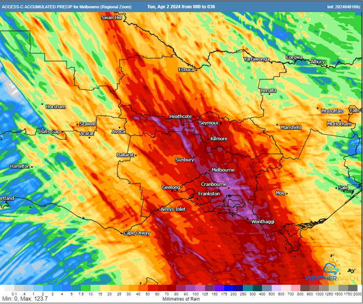
ACCESS C accumulated rainfall next 36 hours. Image via WeatherWatch MetCentre
Despite this, any significant weather threats will have passed this region by Tuesday afternoon. However, the focus will shift to eastern NSW and southern Queensland, with the potential for a significant East Coast Low to develop over the weekend.
On Wednesday, a southerly change will move into northeastern NSW and stall. During the afternoon and evening, scattered showers and isolated storms will develop. This storm activity will extend to the northwest along a trough line into central Queensland.
During Thursday, a slow-moving high in the Tasman Sea and a secondary high near the North Island of NZ will combine to drive moisture-laden easterly winds onto the Queensland and NSW coast, penetrating inland and providing further fuel for rain and storms.
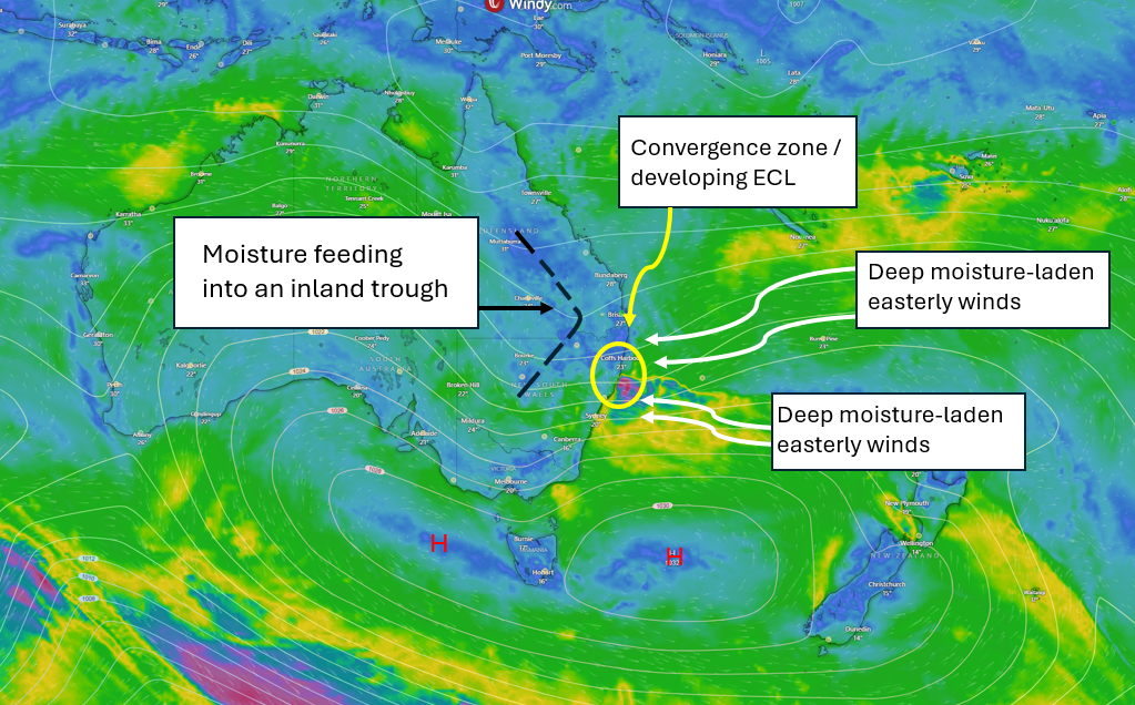
Surface chart via Windy,com
This moisture-laden air will undercut a developing cut-off low forecast to shift into northern NSW and southern Queensland late Thursday into Friday and strengthen. This will increase instability across the region as a large slab of cold air in the upper atmosphere passes.
As this cut-off low drifts closer to the coastal plain, it will help drag a deep northeasterly wind feed through southern Queensland and NSW. In response, a small coastal trough is expected to develop on Friday with a convergence zone along the coastal fringe. This area of two converging winds may produce heavy to locally intense rainfall. Friday night, this trough will likely become a small East Coast Low off the Mid North Coast or Hunter Coast of NSW.
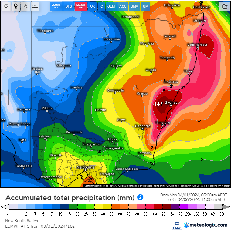
ECMWF AIFS forecast precipitation to 11pm Saturday 6/04/2024. Image via Meteologix
What is a cut-off low?
A cut-off low is a low-pressure system that has been pinched off or cut off from the main belt of westerly winds aloft. These systems have a strong cold pool of air associated with them in the mid-to-upper level of the atmosphere (5 to 6 kilometers high) and can be notoriously hard to forecast.
Cut-off lows also aid in the development of East Coast Lows. As this low and associated cold pool drifts over eastern Australia, it lifts the air ahead of it and interacts with warm ocean temperatures off the East Coast of Australia (East Australia Current). As these two systems interact, the East Coast Low begins to deepen, producing damaging to destructive winds, heavy rainfall, and large waves that batter coastal areas.
What is an East Coast Low and Cut-Off Low. Video via BoM
Cut-off lows and East Coast Lows can occur at any time of year, but they are most prevalent during the autumn and winter months.
Cut-off lows can help to produce devastating rainfall events due to their slow-moving nature. I.E., The Southeast Queensland flood event of 2022
Cut-off low meanders across NSW late Friday into Saturday creating widespread severe weather. Gif via WeatherWatch MetCentre.
As this low develops, rainfall across northern NSW will gradually ease as drier southwest to northwest winds develop. However, the focus for very heavy rain will shift to regions south of this developing ECL.
While this potential system is still a way off, and variations will likely occur between when this story was written and impact over the weekend, some areas of the central and southern NSW coastline will likely see heavy rainfall develop in response, with flash flooding expected.
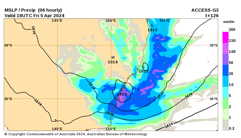
ACCESS G3 Mean Sea Level Pressure (MSLP) & forecast precipitation Saturday morning. Image via BoM
Damaging wind gusts to 110km/h will likely impact coastal regions and adjacent higher elevations from Forster south into the weekend, with large and powerful waves also expected to cause havoc across the coastal fringe.
Boat-goers and rock fishing enthusiasts will be advised to stay clear of dangerous conditions developing should this potential ECL drift down the NSW coastline.
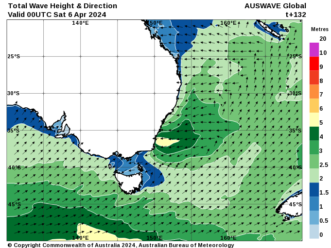
Total wave height and direction for 11am Saturday Image via BoM.
This is not a drill; Rainfall will increase across parts of Queensland and NSW over the next week....
Parts of central and southern Queensland will see an increase in rain and storms this weekend as a...
The oppressive heat hammering parts of South Australia will go out with a bang on Friday ahead of...