Widespread severe weather outbreak to hammer several states
While we saw extreme heat across the country over the weekend, this week will see the return of...
During the last two weeks, there have been dangerous thunderstorm events in both NSW and Queensland that have resulted in severe damage and even loss of life - but what was particularly dangerous about these storms?
In New South Wales last Saturday, intense and sudden storms hit the Long Jetty and Toowoon Bay areas late in the afternoon, with strong winds causing extensive damage. Trees were uprooted, vehicles crushed, roofs ripped off and buildings damaged. Power was out for up to 8 hours in some areas of Long Jetty, with over 3000 addresses affected.
Just a week later, more storms formed in Southeast Queensland, which caused even greater damage from severe microbursts of wind. Much of the storm activity occurred over Archerfield where multiple small planes broke free from ties and were blown around the airfield, causing millions of dollars of damage. Media outlets showed trees being flung across traffic, causing incredibly dangerous conditions for people on the road.
What is a Microburst?
A microburst is a sudden, powerful, column of sinking air called a downdraft which particularly occur during severe thunderstorms. As a thunderstorm matures, it can release a burst of air downward at high speeds. This occurs because the rain-cooled air within the storm is much denser than the warm air outside it. The heavier, cooler air plunges towards the ground, hits the ground, and spreads out in all directions. This can create wind speeds of up to 270km/hr - as strong as an F1 tornado, in a condensed area, typically less than 4 kilometers in diameter. Microbursts develop in thunderstorms so are more likely to occur during the warmer months when thunderstorm activity is higher.
It is an intense phenomenon that can produce damaging to destructive straight-line winds that span up to 4 kilometres horizontally. This powerful weather phenomenon is driven by evaporative cooling (when precipitation evaporates into the surrounding dry air near the surface), typically weakening as it propagates outwards towards the surface.
Why are Microbursts So Dangerous?
Unlike some weather events that allow time for preparation, microbursts can occur with little warning, making them particularly hazardous for unprepared businesses and communities. The wind speeds in a microburst can rival those of strong tornadoes, and can cause significant damage to buildings, tear trees from the ground, and even have devastating impacts on aviation.
Because microbursts are less well-known than other weather phenomena, there is often a lack of preparedness that can lead to greater damage and disruption.
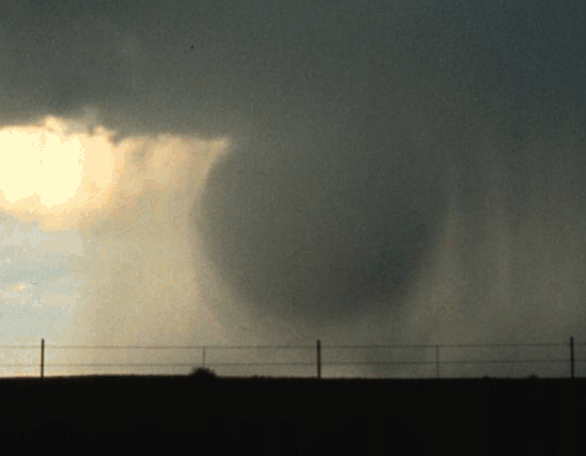 A Microburst being released (Image via Weather.Gov)
What are the implications for businesses?
Understanding microbursts is crucial, especially for industries such as aviation, construction, and agriculture.
For instance, in aviation, microbursts can create wind shear, which has been responsible for several airplane accidents. As seen in Archerfield last week, 9 small aircraft were damaged in the microbursts, causing millions of dollars of damage and putting them out of action.
In construction and outdoor event planning, the sudden winds can cause structural damage, throw materials such as timber, insulation and roofing iron around worksites which pose safety risks to employees and others in the area.
Large freight trucks were knocked over last week as well, causing damage to the trucks and their load, and creating traffic hazards which could have easily seen more vehicles involved. Having freight vehicles out of action while being repaired interrupts delivery timeframes, adding additional costs to companies who would have been relying on a full fleet for their busiest time of year.
Staying Prepared
So, what can businesses do? Awareness and education are key. By incorporating weather monitoring systems, educating employees about emergency protocols, and planning for sudden weather changes, businesses can mitigate the risks posed by these powerful natural events.
EWN’s severe weather alerting services include thunderstorm alerts, and lightning alerts, which are customised for business’s locations and assets for maximum safety across operations. By receiving advanced warning of incoming storms, staff can implement risk mitigation strategies to minimise potential damage and ensure that operations can continue uninterrupted once the threat has passed.
Our clients in the areas around the recent severe storms in SE Queensland and NE NSW received these alerts, allowing them to ensure staff were safely inside, and assets were moved from the dangerous storm activity.
If you want to save your business from damaging storms and severe weather, our team can help. Head to our Contact Page to chat to our team and find out what EWN services will benefit your business.
While we saw extreme heat across the country over the weekend, this week will see the return of...
The blocking pattern, which has been responsible for the essentially unchanging weather across most...
On Sunday, Victoria experienced a severe weather event that was highly unusual for the final week...