Very hot temperatures for today and into this weekend for NSW and the ACT
A series of fronts are helping drag down a very hot air mass sourced from the nation's west, with...
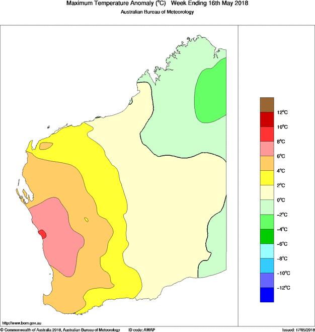
Whilst the east of the nation has finally cooled to near-average May temperatures, the west of the nation is basking in record warmth this late in autumn.
Perth will record its ninth consecutive day of 24 degrees and above today, a record for this late in autumn. And the end of this spell not in sight until at least next Wednesday or Thursday, making the spell likely to last at least 15 or 16 days.
This spell included 32.7 degrees last Saturday, record heat for this late in May.
The warmth is being caused by a prolonged period of high pressure, leading to a lack of any frontal activity. Generally at this time of the year, cold fronts become more active in the southwest, keeping warmth in the north of the state.
Whilst beach goers won?t be complaining, this lack of frontal activity also means the city is enduring very dry conditions, with only 6.2mm recorded so far, amongst the driest on record.
Models indicate a cold front will push through from next Thursday, bringing cooler conditions and hopefully some decent rain.
Image: Maximum temperature anomalies for Western Australia across the last seven days
A series of fronts are helping drag down a very hot air mass sourced from the nation's west, with...
Some of the coldest March weather in decades has gripped southern Australia across the past five...
There has been growing optimism over the last few days about widespread rain across eastern...