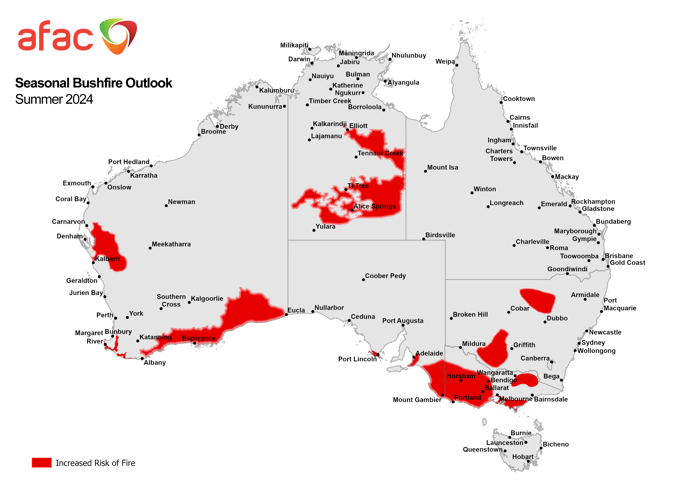
The Seasonal Bushfire Outlook for Summer 2024, released by AFAC today, highlights increased bushfire risk across large areas of Australia. As temperatures remain well above average and many southern regions experience prolonged dryness, the need for proactive fire management and preparedness is paramount.
AFAC’s report emphasises there are heightened bushfire risks in:
- Western Australia: Elevated danger in the southeastern coastline, lower Eyre Peninsula, and Nullarbor due to significant vegetation die-off and curing.
- Victoria and South Australia: Dry forests and grasslands across western Victoria, the Mornington Peninsula, and South Australia’s coastal southeast signal a challenging fire season.
- Northern Territories and Queensland: Long-unburnt areas in the southern NT and grass-rich northern Queensland remain at high risk despite the onset of monsoon conditions in some areas.
Above-average summer temperatures are forecast across most jurisdictions, paired with variable rainfall expectations. While the eastern states might see some rainfall relief, the likelihood of dangerous fire conditions persists.

EWN’s Role in Enhancing Preparedness
At EWN, we aim to equip communities, industries, and emergency services with timely, accurate, and actionable data to mitigate bushfire impacts. With our integrated solutions, we ensure readiness at every stage of the bushfire season.
Real-Time Alerts and Notifications
EWN’s tailored bushfire alerting services keep stakeholders informed of evolving risks and include proactive notifications for critical weather thresholds, fire risks, and changes in conditions. With multi-channel alerts delivered via SMS, email, and web portals, we ensure rapid dissemination for recipients.
GIS Platform for Enhanced Monitoring
Our advanced Geographic Information System (GIS) offers real-time visualisation of fire risks overlayed with critical asset data.
- Custom thresholds for fire weather, enabling industries to act promptly.
- Granular insights into evolving fire dynamics, supporting effective planning and response.
 Image: EWN's GIS platform showcasing real-time bushfire risk zones. The interface highlights customisable thresholds, precise geolocation services, and intuitive visualisation tools to support proactive decision-making and risk mitigation during bushfire season.
Tomorrow.io Bushfire Services
Through our partnership with Tomorrow.io, we deliver cutting-edge bushfire forecasting:
- High-resolution modelling to predict fire spread based on weather, topography, and fuel availability.
- AI-driven analytics to enhance decision-making for emergency services and land managers.
- Continuous updates to ensure adaptability in dynamic conditions.
As AFAC CEO Rob Webb reminds us, “No matter where you live or travel this season, everyone can play an important role in bushfire safety.” For individuals, businesses, and communities, this means staying informed and having actionable plans in place.
EWN is committed to supporting Australia through the challenges of bushfires. Whether you’re managing critical infrastructure, protecting natural resources, or ensuring community safety, our solutions provide the intelligence needed to stay ahead.
Talk to Our Team
Discover how EWN can support your bushfire readiness. Contact us today to learn more about our services.