Heavy falls cause flash flooding across parts of Mackay
Heavy rainfall has lead to flash flooding across parts of Mackay overnight.
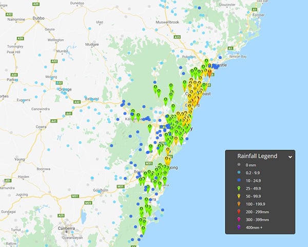
Heavy rainfall has lashed coastal parts of NSW overnight, with falls in excess of 100mm recorded at multiple locations in the 24 hours to 9am this morning.
The coastal trough responsible for the downpour, developed across coastal NSW in response to an upper cold pool of air that has been drifting across the state. This system is expected to linger over the next 24-48 hours with further moderate to heavy falls likely.
Gosford in the Hunter region, recorded the highest total to 9am this morning with 114mm, making it the wettest August day since 2007. Avoca Reservoir received 105mm, Ettalong Public School 107mm, Blacksmiths 109mm and Norah Head picking up 54mm.
In the Illawarra region, Bellambi AWS region picked up 75mm, whilst Sydney (Observatory Hill) scored 43mm to 9am this morning. Sadly, the heavy falls haven't extended far from coastal regions, with Bathurst registering just 5mm, Parkes AP 1.4mm and Scone 1mm.
Further totals of 30-50mm are likely across coastal parts of NSW from the Mid North coast to Illawarra region today, which may lead to localised flash flooding throughout Friday. This activity should slowly contract north during the afternoon hours.
Image 1, current BoM radar at 12:05pm
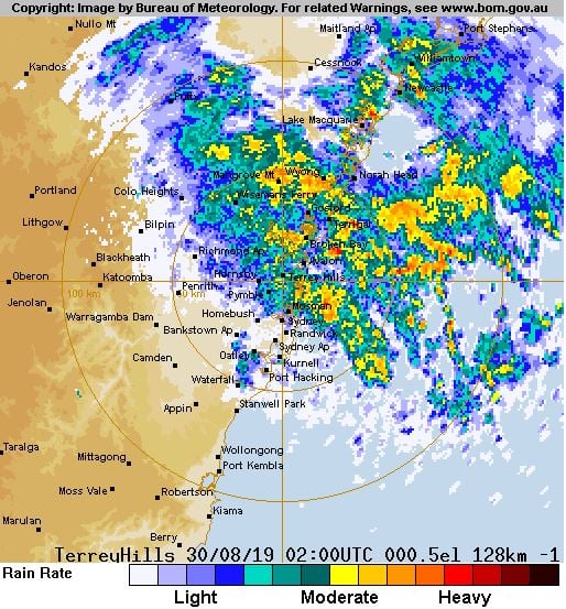
Image 2, EWN rainfall totals 24 hours to 9am 30th August, 2019
Heavy rainfall has lead to flash flooding across parts of Mackay overnight.
A rare dry season rainfall event is set to unfold across parts of the Central QLD coast over the...
Widespread rainfall is beginning to spread across eastern Australia from today, with many parts set...