Australia’s Summer of Extremes: A Season of Severe Storms, Hail, and Cyclones
As summer comes to an end, we reflect on the major weather events that shaped Australia over the...
As we transition into the cooler half of the year, the Bureau of Meteorology (BoM) has released its long-range forecast for May to July 2025, providing a clear picture of the climate conditions Australia can expect over the next three months. Here’s a breakdown of the key insights and what they may mean for operational planning, risk mitigation, and safety.
Australia is facing a very likely warmer-than-average period for both daytime and nighttime temperatures across most of the country.
Above-average daytime maximum temperatures are predicted for almost all of Australia, with greater than 80% probability in many areas.
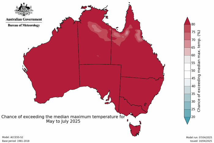
The likelihood of unusually high daytime temperatures is particularly elevated in Southern Western Australia (WA), Eastern New South Wales (NSW), Southeastern Australia, including Tasmania.
Above-average nighttime minimum temperatures are also likely, with chances ranging from 60% to over 80%.
The western half of WA, southern Victoria, and Tasmania are especially likely to experience unusually high overnight temperatures.
The widespread warmth may result in increased energy demand, heightened bushfire risk in drier areas, and implications for agriculture, especially for temperature-sensitive crops and livestock welfare.
While rainfall across the May to July period is expected to sit within typical ranges for much of the country, there are notable regional deviations and month-by-month variations worth highlighting.
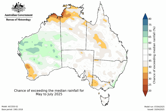
A drier month is expected for much of the country, with below-average rainfall likely west of the Great Dividing Range.
The 60% to 80% probability of below-average rain extends across WA, SA, inland NSW, and QLD.
Continued dryness is forecast for:
Southeast SA
Much of Victoria
Southern and central NSW
Conversely, northern WA may see above-average rainfall, but this comes with the caveat that the region typically receives very low rainfall totals in winter, so even small amounts may exceed the average.
The 3-month cumulative outlook shows:
Below-average rainfall is likely for parts of southwest WA, southeast SA, and Victoria.
Above-average rainfall is possible in the Pilbara and Gascoyne regions of WA.
Elsewhere, rainfall is expected to remain within normal seasonal ranges.
While the dry outlook may reduce flood risks in key areas, water availability, agricultural outputs, and fire weather potential may be affected, especially when combined with elevated temperatures.
With warmer temperatures dominating the seasonal forecast and patchy rainfall predicted, notably drier conditions in May and June, businesses and governments reliant on accurate weather intelligence should prepare for a season of elevated climate variability.
At Early Warning Network, we will continue to monitor these evolving trends to provide:
Tailored alerts for heat spikes, cold snaps, and rainfall deviations
Advanced forecasting to support energy, agriculture, and infrastructure planning
Real-time updates through our alerts and GIS Platform
Now is the time to review weather-sensitive operations, update contingency plans, and stay connected with EWN for proactive alerts and actionable forecasts.
Need help preparing for a warmer, drier winter? Contact our team to learn how EWN’s advanced weather intelligence solutions can support your operational resilience.
As summer comes to an end, we reflect on the major weather events that shaped Australia over the...
At EWN, we’re proud to announce the renewal of our Memorandum of Understanding with Bush Heritage...
Regions across the Northern Territory and Western Australia are currently facing significant...