Severe Weather Headed for WA's South-West
Residents of Western Australia's southwest are being urged to prepare for severe weather as a...
An upper trough and surface trough across inland Australia will shift east today generating scattered showers, storms and rain periods to its east. Overnight Monday into Tuesday, a small low will develop off the southern Queensland coast, with a convergence zone set to develop in the process, primarily between Brisbane and Byron Bay. Along the extreme coastal fringe of southern Queensland and northern NSW, heavy falls are expected to develop, with 50-100mm over the next 12-24 hours. Storm activity will enhance heavier falls, leading to flash flooding across low-lying coastal locations.
Whilst this type of rainfall isn’t uncommon, Autumn 3-monthly historical data dating from 1991 to present shows a gradual decline of seasonal rainfall compared to the 30-year average (1961-1990).
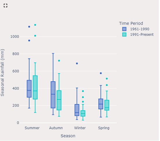
Dataset from EWN's Climatics product, showing a decline in Autumn rainfall
Gale force winds may also develop across coastal locations and offshore waters on Tuesday, with hazardous surfing and marine conditions also expected. Commercial boating and fishing industries may be hampered by this system, particularly across the Gold Coast when trying to enter and exit the Gold Coast seaway. Although this is considered a lower threat, the potential will exist for flights to be disrupted at the Gold Coast Airport during Tuesday morning as this small low deepens just off the coast, with increasing south to southeasterly winds likely across the southern flank of this low. These type of setups can also yield the development of waterspouts along the coast and just offshore.
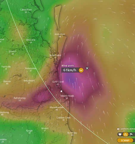
Wind gust forecast for 12pm Tuesday 16 May 2023 from the ECMWF model. Image courtesy of Windy.com
Further inland, rainfall is also expected to increase across agricultural regions of southern Queensland and northern NSW with a few moderate to heavy falls also possible, mainly during Tuesday morning. With a return of neutral El Nino Southern Oscillation conditions, and an expected return of El Nino conditions later this year, late autumn rainfall leading into the winter months will be greatly appreciated for many.
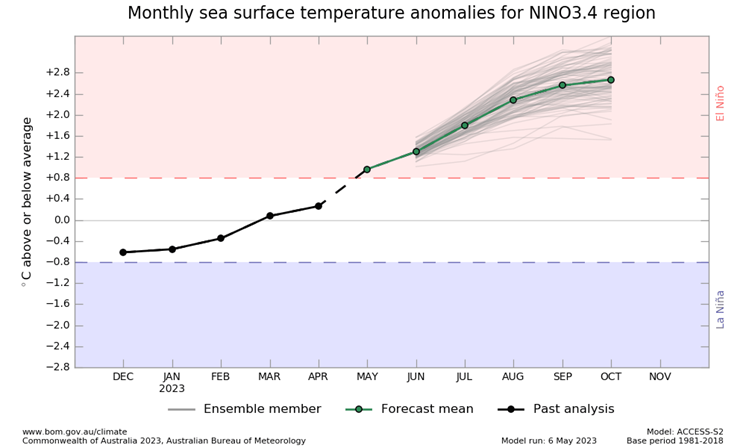
Current El Nino Southern Oscillation outlook. Image courtesy of Bureau of Meteorology
This low will rapidly move away from coastal locations later Tuesday and into Wednesday with a rapid easing of conditions.
If you are in the Marine or Aviation sectors, our Forecasting services can save you money.
Residents of Western Australia's southwest are being urged to prepare for severe weather as a...
A stunning contrast in temperatures exists over NSW this afternoon, with an extremely hot airmass...
The last few days has been extremely active weather wise acoss southeastern and southwestern...