Rare Ex-Tropical Cyclone to cross Sydney overnight Monday into Tuesday; Ex-Tropical Cyclone Kirrily incoming
After tormenting eastern Australia for the better part of two weeks, we are finally about to see...
Parts of the nation's west and the tropics are continuing to experience significant rain and flooding as another burst of the monsoon hits and a dual tropical cyclone threat develops later this week.
.png?width=600&height=468&name=image%20(15).png)
While much of the area is remote, record rainfall has affected many parts of eastern WA over the last few days. A near-stationary trough, due to a blocking high over the eastern states, has been fed by moisture streaming down from the tropics, producing a persistent train of rain. As rain gauges are sporadic in the area with many kilometres between sites, it has been hard to get the entire story of how much rain has occurred; however, we do have numbers for the gauges there are in the area. Eyre has smashed its previous rainfall records, with 141.2mm falling in the 24 hours to 9 am on Sunday - its heaviest fall in 136 years of records. This was then backed up with a further 129.4mm to 9am on Tuesday, and an event total so far of 340.4mm - far exceeding the site's entire annual average (326.7mm).
The terrain is exceptionally flat, so water is struggling to drain, leading to severe flooding. The main transportation arteries into Western Australia have been severed by flooding, as the rains break the long-standing drought over the Nullarbor. The Eyre Highway, a crucial road connecting Perth from the east, has been forced to shut down and the Trans-Australian rail line cut, severely disrupting supply chains and cutting off mine sites. Furthermore, the closures are exacerbated by additional flooding in the northern part of the state, resulting in the closure of the Great Northern Highway between Halls Creek and Fitzroy Crossing. Rawlinna Station, Australia's largest sheep station, is now submerged in water. The situation is dire, with seven individuals missing due to the floodwaters.
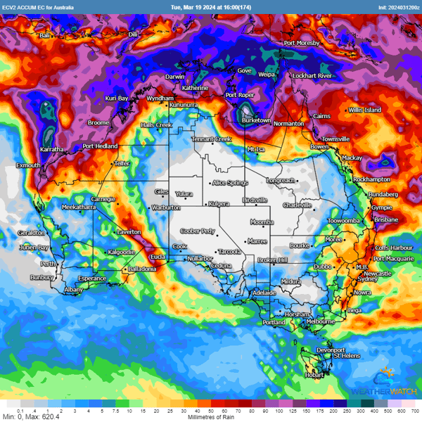
Meanwhile, the monsoon is unleashing heavy rainfall across the tropics, particularly in the WA Kimberley, NT Top End, and QLD Peninsula. Flood watches are in effect for these regions in the coming days, with numerous roads expected to be cut off and communities isolated. The situation could worsen as the risk of tropical cyclone formation looms large throughout the week, with one system expected off WA and another possibly in far north QLD.
The first of these lows (Tropical Low 08U) currently lies south of Christmas Island and is moving towards the east-southeast. According to the Bureau of Meteorology, the system will continue tracking a similar direction at this stage before turning more southerly in a few days and possibly intensifying into a Category 1 system by Friday. There are indications that this system could potentially impact the Pilbara coast later on the weekend or early next week, bringing significant weather changes.
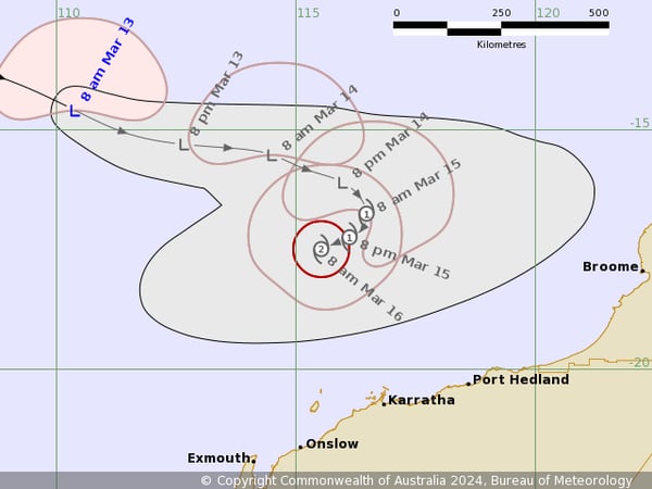
TROPICAL CYCLONE FORECAST TRACK MAP (image via BoM)
Another low is expected to develop in the Timor Sea on Wednesday or Thursday before moving east across the Top End and then possibly into the Gulf of Carpentaria. If this system moves over the warm waters of the Gulf, there is an increased chance of tropical cyclone formation. Where this system may then track is uncertain, although there are indications it may track westwards again into the Northern Territory.
It is certainly shaping up to be a wet week for the aforementioned areas. Southeast WA could still see a further 50-100mm across the next 24 hours, whilst widespread falls of 100-200mm are likely across the northern tropics during the week, with some areas possibly seeing in excess of 400-500mm especially near any tropical lows or cyclones. This significant rainfall potential underscores the need to prepare for possible flooding or cyclones.
As we continue to monitor the developments of the severe weather in Western Australia, our focus remains on delivering real-time, accurate weather information to our clients in the area. By implementing our services, including tropical cyclone forecasting, flood threat maps, and severe weather alerts, we are helping our customers prepare and protect their operations as much as possible.
We hope that all in WA are remaining safe, and remind that dangers of driving in floodwaters. Even shallow, slow-moving water can present significant risks, potentially stalling vehicles or leading to loss of control. It's crucial to stay updated with local weather alerts and road conditions, and avoid flood-prone routes during severe weather events. Always prioritise safety and make informed decisions based on the latest local information.
After tormenting eastern Australia for the better part of two weeks, we are finally about to see...
Australia’s Tropical Cyclone season has officially begun, running all the way through until April...
A silent whisper of the name Jasper has been the talking point in Queensland over the past few...