After tormenting eastern Australia for the better part of two weeks, we are finally about to see the last of what was Tropical Cyclone Kirrily.
Over the next 24 hours, the remnants of the now Ex-Tropical Cyclone Kirrily will swiftly move across NSW and exit off the east coast of Australia, after drenching NSW along the way.
Currently situated across far northwestern NSW and southwestern Queensland, it will swiftly move in a southeasterly direction today as a result of an upper trough. Ex-Tropical Cyclone Kirrily will interact with the upper and surface trough, resulting in the associated cloud and rain extending across NSW from the interior to the southeast.

24-hour satellite image as Ex-Tropical Cyclone Kirrily barrels to the southeast. Gif via WeatherWatch
It will continue to generate areas of heavy rainfall and damaging wind gusts. Gusts to 90km/h will be possible for parts of the Upper West of NSW, Channel Country, and Maranoa and Warrego region of Qld. The threat of severe winds will gradually ease during the afternoon hours, with the threat of heavy rainfall contracting into NSW.
That rainfall will gradually spread into central NSW this afternoon and continue to the coastal region during the early hours of Tuesday morning - including the Greater Metropolitan region. The threat of a few storms will also linger into the overnight hours, enhancing localised falls.
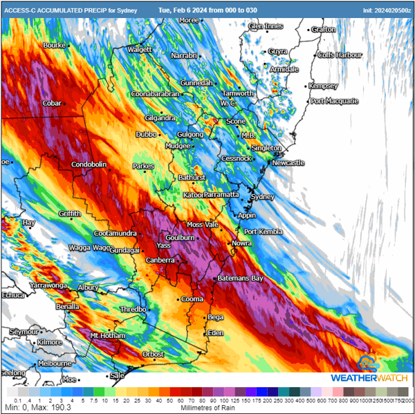
ACCESS C accumulated rainfall totals next 30-hours. Image via WeatherWatch.
The heaviest falls will be to the south and west of Sydney, where accumulated rainfall totals of 50-90mm are expected, with isolated heavier falls approaching 150mm possible. However, the central circulation of Kirrily's remains will likely move across the Sydney to Gosford region during the early hours of Tuesday morning, with a southerly change surging north in its wake.

Hearing the term cyclone and Sydney in the same sentence may seem daunting and unusual. It is uncommon but not unprecedented.
Sydney's weather history is sprinkled with cyclone events like East Coast Lows or Ex-Tropical Cyclones. However, ones that have taken a trajectory, such as Ex-Tropical Cyclone Kirrily from northern Qld into NSW, are a little less common. However, some notable events are Ex-Tropical Cyclone Oswald from 2013 and Tropical Cyclone 119 (TC119) from 1951.
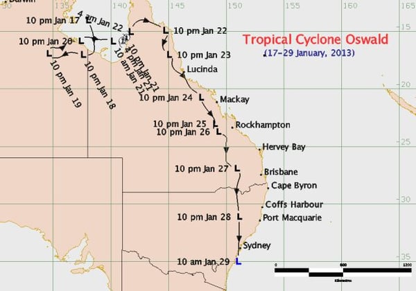
Bureau of Meteorology track for Tropical Cyclone Oswald
A flood watch remains current for parts of NSW, with rivers through the central interior of the state added to the growing list for riverine flooding.
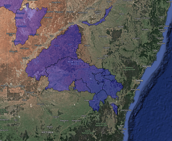
River systems under a flood watch across NSW. Image via EWN.
Recent Articles
Tropical Cyclone Jasper eyes off the Queensland coastline
A silent whisper of the name Jasper has been the talking point in Queensland over the past few...
The Australian Tropical Cyclone season officially begins today
Australia’s Tropical Cyclone season has officially begun, running all the way through until April...