Southeast Australia in the grips of extreme heatwave
Temperatures are soaring into the mid to high 40s across southeastern Australia as a extreme...
It has been a refreshingly cool summer across southeastern Australia so far as persistent rain thanks to La Nina has kept a lid on temperatures, however a prolonged hot spell is beginning to take hold and is set to persist into next week.
An easing of tropical activity has allowed heat to build up over the northwest of the country, and as a tropical low (which is likely to become a cyclone) approaches northwest WA this will push this heat over the nation's southeast for several days, causing the hottest conditions seen so far this summer for many areas.
Temperatures are already soaring today across South Australia, northern Victoria and western New South Wales, with the mercury reaching into the high 30s and low 40s. A fire weather warning for severe fire danger is current in SA, for the West Coast, Eastern Eyre Peninsula, Mid North, Mount Lofty Ranges, Yorke Peninsula and Lower South East.
On Friday, temperatures will start reaching the mid 40s over northern SA, before these temperatures begin affecting more southern parts of the state on Sunday, as well as northern VIC and southern inland and western NSW. Saturday and Sunday will be Adelaide's hottest days of the spell (with seabreezes keeping other days cooler) and is forecast to reach 39 degrees on Saturday and 41 degrees on Sunday. Renmark is forecast to hit 40 degrees on Saturday and 44 degrees on Sunday, whilst Mildura reaches 40 degrees on Saturday and 44 degrees on Sunday.
A cooler change will begin to shift the heat east from Monday, however northerly winds ahead of the change will also help spread heat to coastal areas. On Monday, large parts of NSW (mainly southern and central areas) and Victoria (including coastal areas, especially in central and eastern parts of the state, including Melbourne) are likely to reach into the high 30s or low 40s, with strong winds ahead of the change likely to make this one of the worst fire days of the summer. Grass fires are the highest risk this year due to enhanced growth due to rain.
Tuesday will be hot for many areas but not quite as hot as increased moisture over NSW takes the sting out of the heat, but temperatures will still reach close to 40 degrees in some areas, including western Sydney. From Wednesday, the heat is likely to shift into northern inland NSW and inland Queensland as cooler southerly winds affect the southeast of the country.
Image 1: OCF Forecast Maximum temperatures for Monday 25 January, 2021
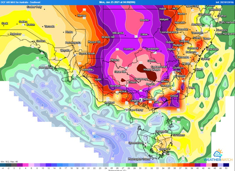
Image 2: Bureau of Meteorology heatwave forecast map from Friday 22nd January to Sunday 24th January, 2021
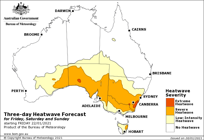
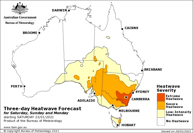
Image 3: Bureau of Meteorology heatwave forecast map from Saturday 23rd January to Monday 25th January, 2021
Temperatures are soaring into the mid to high 40s across southeastern Australia as a extreme...
Temperatures are soaring across South Australia today with large parts of the state pushing into...
An intense band of heat is set to grip southeastern Australia to finish off November, with South...