Damaging winds lash Tasmania
Vigorous westerly winds battered Tasmania overnight, bringing wind gusts in excess of 150km/h that...
A vigorous cold front swept through Tasmania last night and this morning, causing significant damage as wind gusts clocked close to 150km/h.
The southeast of the state was hardest hit, with Hobart recording wind gusts of up to 113km/h (its strongest in almost two years), whilst Mt Wellington was buffeted by wind gusts of 148km/h around 10am this morning.
The winds led to significant damage, with boats breaking their moorings, rooves blown off, windows shattered and trees and powerlines being felled. Power was cut to more than 2500 homes.
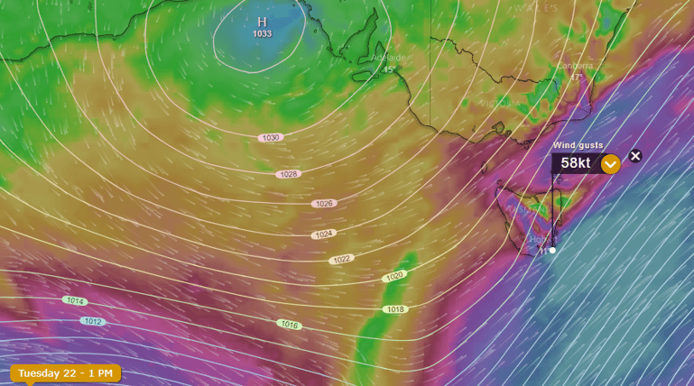
A tight pressure gradient between a high over the Bight and the front contributed to the destructive winds experienced.
It has been a month of severe weather for some parts of Tasmania, with record May rainfall falling in several areas, including Hobart, just a week and a half ago. This has been very different to the remainder of Australia, that has been dominated by persistent dry weather.
Another front will cross the state tomorrow, producing potential for wind gusts of up to 90-120km/h in exposed coastal and elevated areas in the state's south, however the wind gusts are unlikely to be as widespread or sustained, meaning damage potential will be much lower.
Images: Wind gusts and pressure gradient chart for southern Australia (Source: Windy.com)
Vigorous westerly winds battered Tasmania overnight, bringing wind gusts in excess of 150km/h that...
A cold front will sweep across WA's southwest tomorrow, bringing wind gusts to 100km/h but also...
A large cloud band responsible for scattered showers and patchy rain last night is steadily moving...